

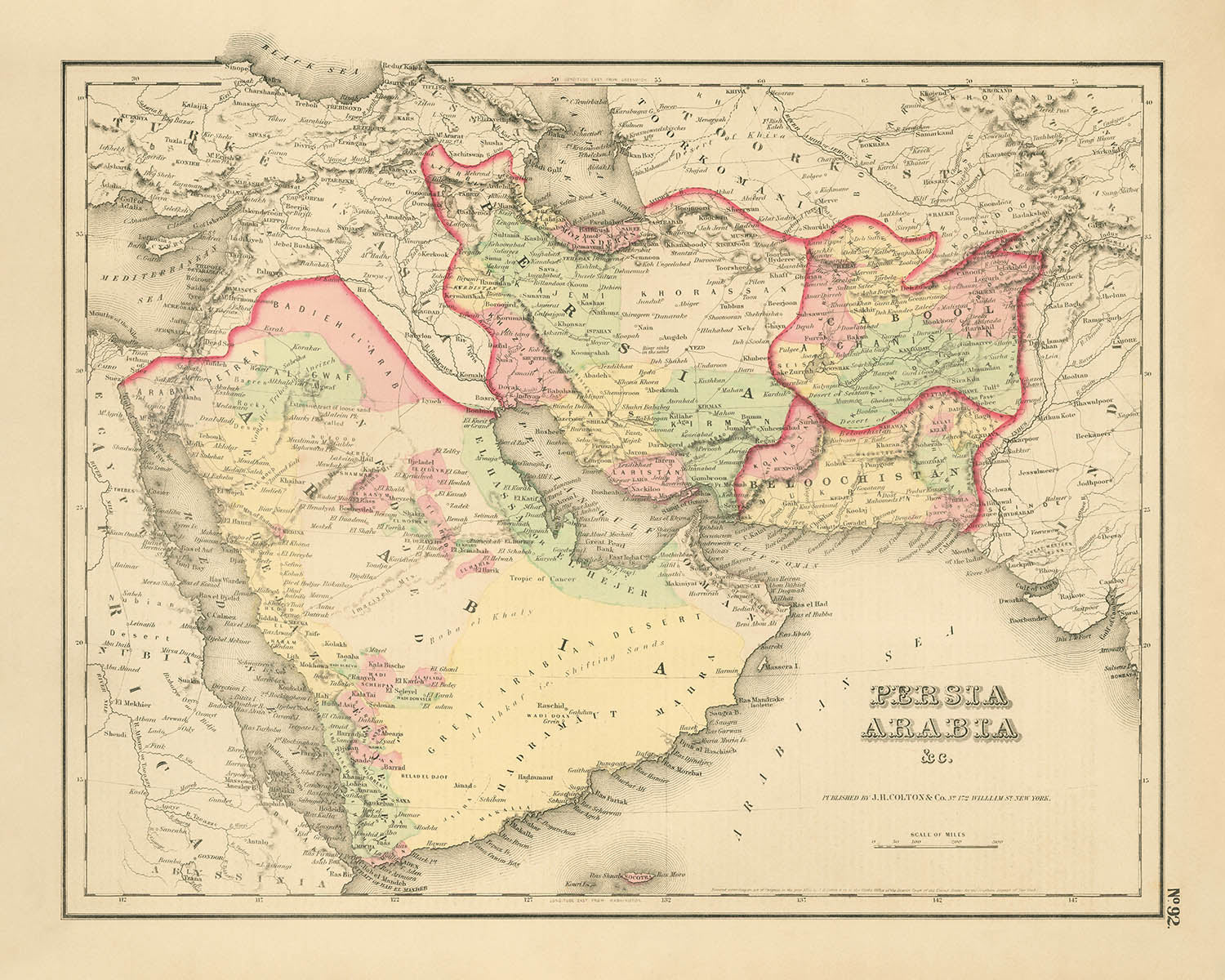


Alte Karte von Persien und Arabien von Colton, 1857: Naher Osten, Persischer Golf, Zagrosgebirge

-
![]() Handmade in the UK (we're based in London)
Handmade in the UK (we're based in London)
-
FREE worldwide delivery in 2-3 days ⓘ
Free Christmas delivery in 2-3 days
Your map should be delivered in 2-3 working days with free delivery, worldwide.
We make maps by hand locally in 23 countries. If you're buying a gift for someone in another country, we will make the map locally to them.
You will never pay import tax or customs duty.
Check the Christmas delivery guide for order deadlines.
Express delivery is available at checkout which can reduce the delivery time to 1-2 days.
Please note that personalised maps, and larger framed maps, can take longer to produce and deliver.
If you need your order to arrive by a certain date, contact me and we can discuss your options.
-
90 day money back guarantee
ⓘ
90 Tage für Rückgabe und Rückerstattung
Produkte können innerhalb von 90 Tagen für eine vollständige Rückerstattung oder einen Umtausch gegen ein anderes Produkt zurückgegeben werden.
Für personalisierte oder maßgefertigte Artikel können wir Ihnen möglicherweise Guthaben im Geschäft oder eine nicht ablaufende Geschenkkarte anbieten, da wir personalisierte Bestellungen nicht wiederverkaufen können.
Wenn Sie Fragen haben, nehmen Sie Kontakt auf. Für weitere Informationen siehe unsere vollständige Rückgabe- und Umtauschrichtlinie.

My maps are rare, museum-grade, restored old maps sourced from libraries, auction houses and private collections across the globe.
Framing & free personalisation available
1. Select your size
2. Frame & personalise your map
Make your map unique with framing, hand-drawn customisation, vintage ageing, pop art text, unique 3D styling and moreGeschenkmitteilung & individuelle Ausführung

Wenn Sie eine Geschenkmitteilung oder eine Ausführung (Puzzle, Aluminiumplatte usw.) hinzufügen möchten, die hier nicht verfügbar ist, geben Sie dies bitte in der "Bestellnotiz" beim Checkout an.
Jede Bestellung wird individuell angefertigt. Wenn Sie die Größe leicht anpassen oder auf einem ungewöhnlichen Material drucken lassen möchten, lassen Sie es uns einfach wissen. Wir haben im Laufe der Jahre Tausende von individuellen Bestellungen bearbeitet, daher gibt es (fast) nichts, was wir nicht bewältigen können.
Sie können uns auch kontaktieren, bevor Sie bestellen, wenn Sie möchten!
Order by 10am tomorrow for free Christmas delivery

- Handmade locally. No import duty or tax
- FREE Delivery. Arrives in 2-3 days
- Love it or your money back
- Questions? WhatsApp me any time
Own a piece of history
5,000+ 5 star reviews


Betreten Sie die komplexe Welt der Kartographie des 19. Jahrhunderts mit "Persien Arabien &c.", einem Meisterwerk, das 1857 vom renommierten Joseph Hutchins Colton veröffentlicht wurde. Diese exquisite Karte, die in New York zur Blütezeit von Coltons Karriere hergestellt wurde, fängt die weiten und geheimnisvollen Landschaften des Nahen Ostens ein, die vom Herzen Persiens bis zu den weitläufigen Wüsten Arabien und den geschichtsträchtigen Küsten des Persischen Golfs reichen. Coltons charakteristischer dekorativer Rand und die zarten Pastellfarben rahmen eine Region im Wandel und bieten einen seltenen Einblick in eine Zeit vor den seismischen geopolitischen Veränderungen, die diese Länder in den folgenden Jahrzehnten neu definieren würden.
Joseph Hutchins Colton wurde für seine akribische Detailgenauigkeit und Kunstfertigkeit gefeiert, und diese Karte ist ein Zeugnis seines Erbes. Seine Karten waren nicht nur Navigationshilfen, sondern auch kulturelle Artefakte, die dazu entworfen wurden, zu informieren und zu inspirieren. Hier stellt Colton die Gebiete des Osmanischen Reiches, Persiens, Afghanistans und Belutschistans mit bemerkenswerter Klarheit dar und zeichnet sowohl politische Grenzen als auch physische Merkmale nach. Die Beschriftung der Regionen wie El Ahsa und El Hejer entlang der Südküste des Golfs spiegelt die Nomenklatur und administrativen Realitäten der Epoche wider, kurz bevor die Osmanen in das östliche Arabien expandierten.
Die geografischen Details der Karte sind ebenso fesselnd wie ihr historischer Kontext. Gebirgszüge wie die rauen Zagros und Elburz sind über Persien eingraviert, während die weiten Wüsten und Küstenebenen Arabien mit Präzision kartiert sind. Die schimmernden Gewässer des Persischen Golfs, des Golfs von Oman und des Arabischen Meeres definieren die maritimen Grenzen der Region, gespickt mit eindrucksvollen Merkmalen wie dem Großen Perlenbank, Goodwins Insel und der Dahnyi-Insel. Diese natürlichen Phänomene hatten immense wirtschaftliche und kulturelle Bedeutung, besonders als die Perlenindustrie des Golfs im 19. Jahrhundert florierte.
Städte und Dörfer sind akribisch eingezeichnet, viele tragen Namen, die durch die Geschichte hallen und in der modernen Welt Resonanz finden. Von der pulsierenden Metropole Teheran und den geschichtsträchtigen Straßen Bagdads bis hin zu den aufstrebenden Siedlungen Dibbah (Dubai), Abothubbee (Abu Dhabi) und Sharjas Tower (Sharjah) kartiert die Karte den Aufstieg urbaner Zentren, die später zu globalen Knotenpunkten werden sollten. Im Golf werden Orte wie Zabarah, El Katif und Bahrein hervorgehoben, während alte Handelsstädte wie Maskat, Sana und Mocha die südlichen Ausläufer der Arabischen Halbinsel verankern.
Was diese Karte auszeichnet, ist ihre Fähigkeit, einen entscheidenden Moment in der Geschichte der Region festzuhalten - einen Kreuzungspunkt von Imperium, Handel und Kultur. Sie bewahrt die Erinnerung an eine Landschaft vor dem modernen Nationalstaat, in der die Grenzen durchlässig waren und Identitäten ebenso sehr durch Geographie wie durch Politik geprägt wurden. Für Sammler und Kenner ist "Persien Arabien &c." nicht nur ein visuell beeindruckendes Artefakt, sondern auch ein Fenster in das dynamische Zusammenspiel von Land, Meer und Gesellschaft, das den Nahen Osten seit Jahrhunderten prägt.
Städte und Dörfer auf dieser Karte
- Vereinigte Arabische Emirate (heutige):
- Dibbah (Dubai)
- Abothubbee (Abu Dhabi)
- Sharjas Tower (Sharjah)
- Ras al Khyme (Ras Al Khaimah)
- Saudi-Arabien (heutige):
- El Katif (Al Qatif)
- El Ahsa (Al-Hasa/Al-Ahsa)
- Duat (wahrscheinlich Dawhat, nahe Katar)
- El Hejer (Al-Hijr/Mada'in Salih)
- Katar (heutige):
- Zabarah (Al Zubarah)
- Ras Aufir (wahrscheinlich Ras Laffan oder ähnlich)
- Bahrain (heutige):
- Bahrein (Bahrain)
- Iran (Persien):
- Teheran (Tehran)
- Ispahan (Isfahan)
- Schiraz
- Tabriz
- Mashad (Mashhad)
- Yezd (Yazd)
- Kerman
- Buschire (Bushehr)
- Resht (Rasht)
- Hamadan
- Irak (Osmanisches Reich zu dieser Zeit):
- Bagdad (Baghdad)
- Bassora (Basra)
- Mosul
- Kerbela (Karbala)
- Hillah
- Afghanistan:
- Herat
- Kandahar
- Kabul
- Balkh
- Pakistan (Belutschistan):
- Kelat (Kalat)
- Quetta
- Oman:
- Maskat
- Jemen:
- Sana (Sana'a)
- Mocha
Bemerkenswerte Merkmale & Sehenswürdigkeiten
- Persischer Golf (so beschriftet)
- Golf von Oman
- Arabisches Meer
- Rotes Meer
- Kaspisches Meer (teilweise oben sichtbar)
- Umrisse großer Reiche und Regionen: Osmanisches Reich, Persien, Afghanistan, Belutschistan
- Provinz- und Regionsgrenzen innerhalb dieser größeren Einheiten
- Zagrosgebirge (in Persien/Iran)
- Elburzgebirge (nördlich von Persien/Iran)
- Andere Gebirgszüge in Afghanistan und entlang der Arabischen Halbinsel
- Bahrain (Bahrein)
- Goodwin-Insel
- Dahnyi-Insel
- Die Große Perlenbank (im Golf nahe Bahrain/Qatar beschriftet)
- Dekorativer Rand, typisch für Coltons Stil
Historischer und gestalterischer Kontext
- Name der Karte: Persien Arabien &c.
- Kartenmacher/Herausgeber: Joseph Hutchins Colton, ein prominenter amerikanischer Kartenmacher des 19. Jahrhunderts, bekannt für seine detaillierten und dekorativen Karten, veröffentlicht in New York.
- Erstellungsdatum: 1857.
- Die Karte konzentriert sich auf die Arabische Halbinsel und den Persischen Golf und umfasst auch das Osmanische Reich, Persien (das heutige Iran), Afghanistan, Belutschistan (Balochistan) und angrenzende Regionen.
- Die Karte ist sowohl eine politische als auch eine physische Karte, die Grenzen, Provinzen und physische Merkmale wie Gebirgszüge und Gewässer zeigt.
- Die Karte entstand vor der Al-Hasa-Expedition von 1871, die dazu führte, dass das Osmanische Reich seinen Einfluss auf die östliche Arabische Halbinsel (El Ahsa/El Hejer-Region) ausdehnte.
- Die Südküste des Golfs ist als El Ahsa oder El Hejer beschriftet, was die damalige Nomenklatur vor den administrativen Änderungen des Osmanischen Reiches widerspiegelt.
- Frühe Formen von Namen für die heutigen Emirate der VAE, wie Sharjas Tower (Sharjah), Dibbah (Dubai), Abothubbee (Abu Dhabi) und Ras al Khyme (Ras Al Khaimah), sind dargestellt.
- In der Nähe von Katar und Bahrain sind Merkmale wie Ras Aufir, Zabarah, El Katif, Duat, die Große Perlenbank, Goodwin-Insel und Dahnyi-Insel dargestellt.
- Die Karte bietet einen Einblick in das politische und geografische Wissen der Region im mittleren 19. Jahrhundert, vor großen geopolitischen Veränderungen wie der Expansion des Osmanischen Reiches in das östliche Arabien.
Bitte überprüfen Sie die Bilder, um sicherzustellen, dass eine bestimmte Stadt oder ein Ort auf dieser Karte angezeigt wird. Sie können uns auch kontaktieren und bitten, die Karte für Sie zu überprüfen.
Diese Karte sieht in jeder Größe großartig aus, aber ich empfehle immer, eine größere Größe zu wählen, wenn Sie Platz haben. So können Sie alle Details leicht erkennen.
Diese Karte sieht in Größen bis zu 70 Zoll (180 cm) erstaunlich aus. Wenn Sie nach einer größeren Karte suchen, bitte kontaktieren Sie uns.
Das Modell in den Bildanzeigen hält die 16x20 Zoll (40x50 cm) Version dieser Karte.
Das fünfte Abbildungsbild zeigt ein Beispiel für meinen Kartenpersonalisierungsservice.
Wenn Sie nach etwas etwas anderem suchen, schauen Sie sich meine Sammlung der besten alten Karten an, um zu sehen, ob etwas anderes Ihr Interesse weckt.
Bitte kontaktieren Sie mich, um zu überprüfen, ob ein bestimmter Ort, ein Wahrzeichen oder ein Merkmal auf dieser Karte angezeigt wird.
Das wäre ein wunderbares Geburtstags-, Weihnachts-, Vatertags-, Abschiedsgeschenk, Jubiläum oder Einweihungsgeschenk für jemanden aus den Gebieten, die von dieser Karte abgedeckt werden.
Diese Karte ist als Giclée-Druck auf säurefreiem, archiviertem mattem Papier erhältlich, oder Sie können sie gerahmt kaufen. Der Rahmen ist ein schöner, einfacher schwarzer Rahmen, der zu den meisten Ästhetiken passt. Bitte kontaktieren Sie mich, wenn Sie eine andere Rahmenfarbe oder -material wünschen. Meine Rahmen sind mit superklarem museumsglänzendem Acryl (Plexiglas/Acrylt) verglast, das deutlich weniger reflektierend als Glas ist, sicherer und immer in einwandfreiem Zustand ankommt.
This map is also available as a float framed canvas, sometimes known as a shadow gap framed canvas or canvas floater. The map is printed on artist's cotton canvas and then stretched over a handmade box frame. We then "float" the canvas inside a wooden frame, which is available in a range of colours (black, dark brown, oak, antique gold and white). This is a wonderful way to present a map without glazing in front. See some examples of float framed canvas maps and explore the differences between my different finishes.
For something truly unique, this map is also available in "Unique 3D", our trademarked process that dramatically transforms the map so that it has a wonderful sense of depth. We combine the original map with detailed topography and elevation data, so that mountains and the terrain really "pop". For more info and examples of 3D maps, check my Unique 3D page.
Für die meisten Bestellungen beträgt die Lieferzeit etwa 3 Werktage. Personalisierte und maßgeschneiderte Produkte benötigen länger, da ich die Personalisierung durchführen und sie Ihnen zur Genehmigung zusenden muss, was normalerweise 1 oder 2 Tage dauert.
Bitte beachten Sie, dass sehr große gerahmte Bestellungen in der Regel länger für die Herstellung und Lieferung benötigen.
Wenn Sie möchten, dass Ihre Bestellung bis zu einem bestimmten Datum ankommt, bitte kontaktieren Sie mich, bevor Sie bestellen, damit wir den besten Weg finden können, um sicherzustellen, dass Sie Ihre Bestellung rechtzeitig erhalten.
Ich drucke und rahme Karten und Kunstwerke in 23 Ländern weltweit. Das bedeutet, dass Ihre Bestellung lokal gefertigt wird, was die Lieferzeit verkürzt und sicherstellt, dass sie während der Lieferung nicht beschädigt wird. Sie zahlen nie Zoll oder Einfuhrgebühren, und wir stoßen weniger CO2 in die Luft aus.
Alle meine Karten und Kunstdrucke sind gut verpackt und werden in einem robusten Rohr versendet, wenn sie ungerahmt sind, oder von Schaum umgeben, wenn sie gerahmt sind.
Ich versuche, alle Bestellungen innerhalb von 1 oder 2 Tagen nach Erhalt Ihrer Bestellung zu versenden, obwohl einige Produkte (wie Gesichtsmasken, Tassen und Tragetaschen) länger zur Herstellung benötigen können.
Wenn Sie Express-Lieferung an der Kasse auswählen, priorisieren wir Ihre Bestellung und versenden sie per 1-Tages-Kurier (Fedex, DHL, UPS, Parcelforce).
Nächster Tag Lieferung ist auch in einigen Ländern verfügbar (USA, UK, Singapur, VAE), aber bitte versuchen Sie, früh am Tag zu bestellen, damit wir es rechtzeitig versenden können.
Lesen Sie meinen vollständigen Leitfaden zur Lieferung und lokalen Produktion
Mein Standardrahmen ist ein Galerie-Stil-Rahmen aus schwarzem Eschenholz. Er ist einfach und sieht ziemlich modern aus. Mein Standardrahmen ist etwa 20 mm (0,8 Zoll) breit.
Ich verwende super-klares Acryl (Plexiglas/Acrylt) für das Glas des Rahmens. Es ist leichter und sicherer als Glas – und es sieht besser aus, da die Reflexion geringer ist.
Sechs Standardrahmenfarben sind kostenlos erhältlich (schwarz, dunkelbraun, dunkelgrau, Eiche, weiß und antikgold).
Die meisten Karten, Kunstwerke und Illustrationen sind auch als gerahmte Leinwand erhältlich. Wir verwenden matte (nicht glänzende) Baumwollleinwand, spannen sie über einen nachhaltig beschafften Buchenrahmen und 'schweben' dann das Stück innerhalb eines Holzrahmens. Das Endergebnis ist ziemlich schön, und es gibt keine Verglasung, die im Weg ist.
Alle Rahmen werden "bereit zum Aufhängen" geliefert, entweder mit einer Schnur oder Halterungen auf der Rückseite. Sehr große Rahmen haben schwere Aufhängeplatten und/oder eine Montageschiene. Wenn Sie Fragen haben, können Sie bitte Kontakt aufnehmen.
Sehen Sie sich einige Beispiele meiner gerahmten Karten und gerahmten Leinwandkarten an.
Alternativ kann ich auch alte Karten und Kunstwerke auf Leinwand, Schaumstoffplatten, Baumwollrag und andere Materialien liefern.
Wenn Sie Ihre Karte oder Ihr Kunstwerk selbst rahmen möchten, lesen Sie bitte zuerst meinen Größenleitfaden.
Einige meiner alten Karten sind jetzt als gerahmte Leinwände erhältlich. Bitte kontaktiere mich, wenn du eine Größe bestellen möchtest, die in meinem Shop nicht verfügbar ist.
Leinwand alte Karten sind eine interessante Alternative zu konventionell gerahmten Karten. Je nach deinem persönlichen Geschmack und der Raumdekoration können Leinwandkarten etwas mehr „herausstechen“ als eine gerahmte Karte.
Meine Karten sind äußerst hochwertige Reproduktionen von Originalkarten.
Ich beziehe originale, seltene Karten aus Bibliotheken, Auktionshäusern und Privatsammlungen auf der ganzen Welt, restauriere sie in meiner Londoner Werkstatt und erstelle dann mit speziellen Giclée-Tinten und -Druckern wunderschöne Karten, die sogar noch besser aussehen als das Original.
Meine Karten werden auf säurefreiem, mattem Archivpapier (nicht glänzend) gedruckt, das sich sehr hochwertig anfühlt und fast wie Karton aussieht. Technisch gesehen beträgt das Papiergewicht/die Papierdicke 10mil/200g/m². Es eignet sich perfekt zum Einrahmen.
Ich drucke mit UV-lichtbeständigen Ultrachrome-Giclée-Pigmenttinten von Epson – einige der besten Tinten, die Sie finden können.
Ich kann auch machen Karten auf Leinwand, Baumwolllappen und andere exotische Materialien.
Erfahren Sie mehr über The Unique Maps Co.
Kartenpersonalisierung
Wenn Sie nach dem perfekten Geschenk zum Jahrestag oder zur Einweihung suchen, kann ich Ihre Karte personalisieren, um sie wirklich einzigartig zu machen. Ich kann beispielsweise eine kurze Nachricht hinzufügen, einen wichtigen Ort hervorheben oder das Wappen Ihrer Familie hinzufügen.
Die Möglichkeiten sind nahezu unbegrenzt. Bitte sehen Sie sich meine Kartenpersonalisierungsseite für einige wunderbare Beispiele dessen, was möglich ist.
Um eine personalisierte Karte zu bestellen, wählen Sie „Personalisieren Sie Ihre Karte“, bevor Sie sie in den Warenkorb legen.
In Kontakt kommen wenn Sie nach komplexeren Anpassungen und Personalisierungen suchen.
Kartenalterung
Im Laufe der Jahre wurde ich von Kunden hunderte Male gefragt, ob sie eine Karte kaufen könnten, die noch älter.
Nun, jetzt können Sie das, indem Sie „Alter“ auswählen, bevor Sie eine Karte in Ihren Warenkorb legen.
Alle Produktfotos, die Sie auf dieser Seite sehen, zeigen die Karte in ihrer Originalform. So sieht die Karte heute aus.
Wenn Sie „Gealtert“ auswählen, werde ich Ihre Karte von Hand altern lassen. Dazu verwende ich ein spezielles und einzigartiges Verfahren, das ich durch jahrelanges Studium alter Karten und Gespräche mit Forschern zum Verständnis der Chemie alternder Papiere entwickelt habe, und natürlich ... viel Übung!
Wenn Sie sich nicht sicher sind, bleiben Sie bei der Originalfarbe der Karte. Wenn Sie etwas Dunkleres und älter Wenn Sie auf der Suche sind, entscheiden Sie sich für „Aged“.
Sehen Sie einige erstaunliche Beispiele für gealterte Karten.
Wenn Sie aus irgendeinem Grund mit Ihrer Bestellung nicht zufrieden sind, kontaktieren Sie mich für eine unkomplizierte Rückerstattung. Bitte sehen Sie sich unsere Rückgabe- und Rückerstattungsrichtlinien für weitere Informationen an.
Ich bin sehr zuversichtlich, dass Ihnen Ihre restaurierte Karte oder Kunstdruck gefallen wird. Ich mache das seit 1984. Ich bin ein 5-Sterne Etsy-Verkäufer. Ich habe Zehntausende von Karten und Kunstdrucken verkauft und habe über 5.000 echte 5-Sterne-Bewertungen.
Ich verwende einen einzigartigen Prozess, um Karten und Kunstwerke zu restaurieren, der extrem zeitaufwendig und arbeitsintensiv ist. Die Suche nach den Originalkarten und Illustrationen kann Monate dauern. Ich benutze modernste und unglaublich teure Technologie, um sie zu scannen und wiederherzustellen. Daher garantiere ich, dass meine Karten und Kunstdrucke eine Klasse für sich sind - deshalb kann ich eine unkomplizierte Rückerstattung anbieten.
Fast alle meine Karten und Kunstdrucke sehen in großen Größen (200 cm, 6,5 Fuß+) erstaunlich aus und ich kann sie Ihnen auch gerahmt und über einen speziellen Übergrößen-Kurier liefern. Kontaktieren Sie mich, um Ihre speziellen Bedürfnisse zu besprechen.
Or try searching for something!


