


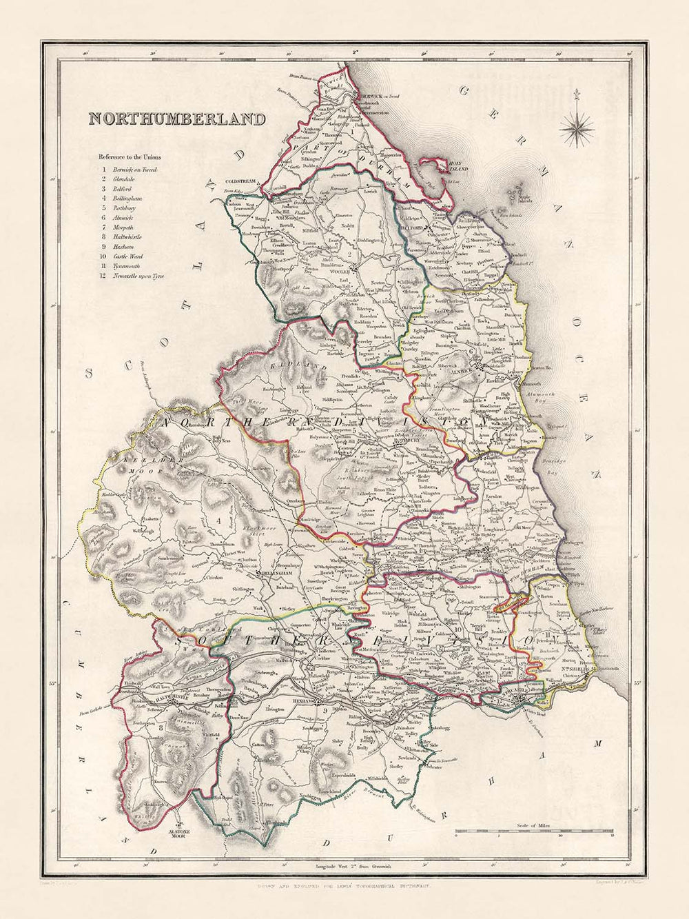


Alte Karte von Northumberland von Samuel Lewis, 1844: Newcastle upon Tyne, Blyth, Cramlington, Ashington und Bedlington
20% Rabatt auf 2 — 33% Rabatt auf 3
Fügen Sie beliebige zwei berechtigte Artikel zu Ihrem Warenkorb hinzu, um 20% Rabatt zu erhalten. Fügen Sie einen dritten hinzu und er ist kostenlos (entspricht 33% Rabatt, wenn Sie drei kaufen).
Kein Code erforderlich — das Angebot wird automatisch an der Kasse angewendet.
Gültig für alle Standardkarten und Kunstdrucke. Sie können beliebige Designs kombinieren.
Wenn Sie Artikel an mehrere Adressen versenden möchten, kontaktieren Sie uns bitte, bevor Sie Ihre Bestellung aufgeben.
Maßanfertigungen und individuelle Aufträge sind ausgeschlossen.
Kontaktieren Sie uns wenn Sie Fragen haben
-
![]() Handmade in the UK (we're based in London)
Handmade in the UK (we're based in London)

-
FREE worldwide delivery in 2-3 days ⓘ
Free delivery in 2-3 days
Your map should be delivered in 2-3 working days with free delivery, worldwide.
We make maps by hand locally in 23 countries. If you're buying a gift for someone in another country, we will make the map locally to them.
You will never pay import tax or customs duty.
Express delivery is available at checkout which can reduce the delivery time to 1-2 days.
Please note that personalised maps, and larger framed maps, can take longer to produce and deliver.
If you need your order to arrive by a certain date, contact me and we can discuss your options.
-
Complimentary gifting & design advice
ⓘ
Complimentary gifting & design advice
Available almost 24/7 on WhatsApp and email — we usually reply within minutes. We can help you:
- Choose a perfectly personalised gift
- Send a digital gift preview to the recipient
- Pick the ideal size for your wall
- Select the right finish and frame
Quick, friendly advice so you can order with confidence.
For last minute gifts, consider buying a digital gift card. We have over 5,000 maps and art prints to choose from.
-
90-day returns & 5-year guarantee
ⓘ
90 Tage für Rückgabe und Rückerstattung
Produkte können innerhalb von 90 Tagen für eine vollständige Rückerstattung oder einen Umtausch gegen ein anderes Produkt zurückgegeben werden.
Für personalisierte und maßgefertigte Artikel können wir Ihnen möglicherweise einen Gutschein oder eine nicht ablaufende Geschenkkarte anbieten, da wir personalisierte Bestellungen nicht weiterverkaufen können.
Wenn Sie Fragen haben, kontaktieren Sie uns. Für weitere Informationen siehe unsere vollständige Rückgabe- und Umtauschrichtlinie.

This is a museum-grade archival print from the original 1844 map — restored in our workshop and made to order on 220gsm archival matte paper or 400gsm artist's cotton canvas with pigment inks.
Professional framing & free personalisation available.
1. Choose a size
2. Frame & personalise your map
Make your map unique with framing, hand-drawn customisation, vintage ageing, pop art text, unique 3D styling and more.


Geschenkmitteilung & individuelle Ausführung

Wenn Sie eine Geschenkmitteilung oder eine Ausführung (Puzzle, Aluminiumplatte usw.) hinzufügen möchten, die hier nicht verfügbar ist, geben Sie dies bitte in der "Bestellnotiz" beim Checkout an.
Jede Bestellung wird individuell angefertigt. Wenn Sie die Größe leicht anpassen oder auf einem ungewöhnlichen Material drucken lassen möchten, lassen Sie es uns einfach wissen. Wir haben im Laufe der Jahre Tausende von individuellen Bestellungen bearbeitet, daher gibt es (fast) nichts, was wir nicht bewältigen können.
Sie können uns auch kontaktieren, bevor Sie bestellen, wenn Sie möchten!

- Handmade locally. No import duty or tax
- FREE worldwide delivery
- 90-day returns & 5-year product guarantee
- Questions? WhatsApp me any time
Own a piece of history
7,000+ 5 star reviews


Tauchen Sie ein in die Vergangenheit mit dieser antiken Karte von Northumberland, die 1844 von Samuel Lewis sorgfältig erstellt wurde. Voller Geschichte bietet dieses Stück einen unvergleichlichen Blick auf das Grafschaft zu einer Zeit bedeutender sozialer, wirtschaftlicher und geografischer Veränderungen. Die Karte verkörpert sowohl den Geist ihrer Zeit als auch die zeitlose Schönheit der Kartographie und steht als Zeugnis für die reiche Geschichte von Northumberland, einer Region, die von Siedlungen geprägt ist, die bis in die römische Ära zurückreichen.
Angesichts ihres Alters zeigt die Karte einige Siedlungen unter früheren Namen, was für den geschichtsinteressierten Betrachter eine zusätzliche Spannung hinzufügt. Einige moderne Städte sind möglicherweise nicht vorhanden, was die sich entwickelnde Landschaft und das dynamische Wachstum der Region im Laufe der Zeit widerspiegelt. Mit ihren klaren Linien und komplizierten Details ist diese Karte von 1844 nicht nur ein Schnappschuss der Vergangenheit – sie ist ein Kunstwerk und ein historisches Dokument in einem.
Bemerkenswerte Siedlungen:
- Newcastle upon Tyne (1080): Gegründet als Festung und Brücke von den Römern und später von den Normannen zu einer wichtigen Siedlung ausgebaut, ist es heute die bevölkerungsreichste Stadt Northumberlands.
- Blyth (12. Jahrhundert): Ursprünglich als Hafenstadt entstanden, hat sich Blyth zu einem bedeutenden Handelszentrum entwickelt, das für seinen lebhaften Hafen bekannt ist.
- Cramlington (1135): Ursprünglich ein kleines Dorf mit einer landwirtschaftlichen Wirtschaft, ist Cramlington heute eine geschäftige Stadt, die für ihre Industrien bekannt ist.
- Ashington (1847): Bekannt für sein Erbe im Kohlenbergbau, wurde Ashington als "das größte Kohlenbergbaudorf der Welt" bezeichnet.
- Bedlington (frühes 12. Jahrhundert): Bekannt für seine Eisenwerke und die Nagelherstellung im 19. Jahrhundert, war es eine bedeutende Industriestadt.
- Berwick-upon-Tweed (ca. 1018): Die nördlichste Stadt in England, bekannt für ihre turbulente Geschichte mit wechselnder schottischer und englischer Herrschaft.
- Hexham (674 n. Chr.): Berühmt für die Hexham Abbey, ist es eine der ältesten erhaltenen christlichen Stiftungen in Großbritannien.
- Prudhoe (1150): Bekannt für das Prudhoe Castle, ein schönes Beispiel für eine normannische Festung.
- Morpeth (1199): Eine historische Marktstadt, bekannt für ihre einzigartige Mischung aus Erbe und Schönheit.
- Amble (1200er Jahre): Einst ein bedeutender Seehafen, ist Amble heute eine beliebte Urlaubsstadt, die für ihren Yachthafen und ihre schönen Strände bekannt ist.
- Alnwick (ca. 600 n. Chr.): Berühmt für das Alnwick Castle, einen Drehort der Harry-Potter-Serie.
- Ponteland (13. Jahrhundert): Bekannt für seine schönen ländlichen Landschaften und das Ponteland Castle.
- Haltwhistle (1200er Jahre): Behauptet, das geografische Zentrum von Großbritannien zu sein und in der Nähe des römischen Hadrianswalls zu liegen.
- Bellingham (frühes 13. Jahrhundert): Tor zum Northumberland Nationalpark, bekannt für seine natürliche Schönheit.
- Wylam (12. Jahrhundert): Geburtsort von George Stephenson, einem Pionier der Eisenbahntechnik.
- Corbridge (786 n. Chr.): Bekannt für seine römische archäologische Stätte, die Corbridge Roman Town.
- Allendale Town (1700er Jahre): Berühmt für das Allendale Tar Bar'l, eine einzigartige Silvestertradition.
- Seaton Delaval (11. Jahrhundert): Heimat des architektonisch beeindruckenden Seaton Delaval Hall.
- Alnmouth (1150): Bekannt für seine schönen Sandstrände und die lebhafte Hafenszene.
- Warkworth (8. Jahrhundert): Ein charmantes Dorf, das von der mittelalterlichen Warkworth Castle dominiert wird.
- Rothbury (8. Jahrhundert): Bekannt für seine schönen Landschaften und als Tor zum Northumberland Nationalpark.
- Bamburgh (ca. 420): Bekannt für das imposante Bamburgh Castle und die schönen Strände.
- Wooler (1100er Jahre): Eine malerische Marktstadt, die das Tor zu den Cheviot Hills ist.
- Felton (12. Jahrhundert): Heimat einer blühenden Kunst- und Handwerkszene, gelegen in der Nähe der atemberaubenden Northumberland Coast Area of Outstanding Natural Beauty.
- Otterburn (1086): Bekannt für die Schlacht von Otterburn, die 1388 stattfand.
- Longhoughton (1100er Jahre): Bietet wunderschöne Küstenlinien und Zugang zu einigen der besten Strände in Northumberland.
- Elsdon (12. Jahrhundert): Heimat eines erhaltenen mittelalterlichen befestigten Pfarrhauses und einer Motte-and-Bailey-Burg aus dem 11. Jahrhundert.
- Bardon Mill (1820er Jahre): Liegt in der Nähe von Vindolanda, einer der wichtigsten römischen archäologischen Stätten in Europa.
- Heddon-on-the-Wall (frühes 13. Jahrhundert): Bekannt für seinen Abschnitt der römischen Hadriansmauer.
- Lynemouth (1800er Jahre): Einst ein Kohlenbergbaudorf, ist es jetzt bekannt für sein Kraftwerk.
Natürliche Attraktionen:
- Northumberland Nationalpark: Bietet einige der reinsten Landschaften im Vereinigten Königreich.
- Cheviot Hills: Sanfte Hügel, die die Grenze zwischen England und Schottland markieren.
- Hadriansmauer: Ein UNESCO-Weltkulturerbe, es ist eines der bedeutendsten Überbleibsel der römischen Zeit in Großbritannien.
- Northumberland Coast AONB: Bekannt für seine herausragende natürliche Schönheit, mit Dünen, Klippen und Sandstränden.
Historische Ereignisse (1800-1850):
- 1804-1806: Der Bau der Union Chain Bridge, der ersten fahrzeugtragenden Hängebrücke der Welt.
- 1825: Die Eröffnung der Stanhope and Tyne Railroad, die das Kohletransportsystem verbessert.
- 1838: Die Gründung der Newcastle and Carlisle Railway, die Handel und Reisen fördert.
- 1844: Das Jahr, in dem diese Karte erstellt wurde und das eine Phase bedeutender geografischer Veränderungen und Entwicklungen in Northumberland markiert.
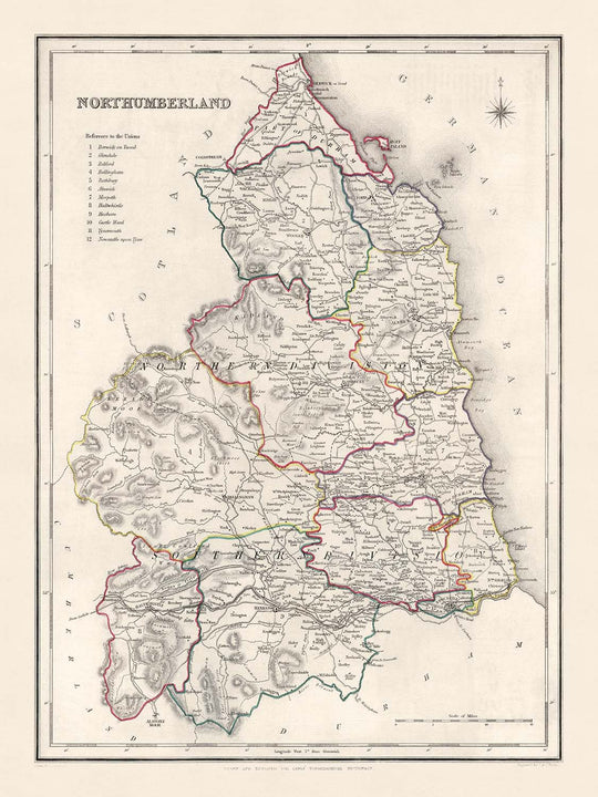
Bitte überprüfen Sie die Bilder, um sicherzustellen, dass eine bestimmte Stadt oder ein Ort auf dieser Karte dargestellt ist. Sie können uns auch kontaktieren und fragen, ob wir die Karte für Sie überprüfen können.
Diese Karte sieht in allen Größen großartig aus: 8x10in (20,5x25,5cm), 12x16in (30,5x41cm), 18x24in (45,5x61cm), 16x20in (40,5x51cm), 24x36in (61x91,5cm), 30x40in (76x101,5cm) und 37x50in (94x127cm), aber sie sieht noch besser aus, wenn sie groß gedruckt wird.
Ich kann schöne, große Drucke dieser Karte bis zu 50in (127cm) erstellen. Bitte kontaktieren Sie mich, wenn Sie nach größeren, maßgeschneiderten oder anderen Rahmenoptionen suchen.
Das Modell in den Angebotsbildern hält die 18x24in (45,5x61cm) Version dieser Karte.
Das fünfte Angebotsbild zeigt ein Beispiel für meinen Personalisierungsservice für Karten.
Wenn Sie nach etwas etwas anderem suchen, schauen Sie sich meine Haupt-Sammlung von Karten des Vereinigten Königreichs und Irlands an.
Bitte kontaktieren Sie mich, um zu überprüfen, ob ein bestimmter Ort, ein Wahrzeichen oder ein Merkmal auf dieser Karte dargestellt ist.
Dies wäre ein wunderbares Geschenk zum Geburtstag, zu Weihnachten, zum Vatertag, zum Abschied von der Arbeit, zum Jubiläum oder zur Einweihung für jemanden aus den Gebieten, die von dieser Karte abgedeckt werden.
Diese Karte ist als Giclée-Druck auf säurefreiem, archivfestem mattem Papier erhältlich, oder Sie können sie gerahmt kaufen. Der Rahmen ist ein schöner, einfacher schwarzer Rahmen, der zu den meisten Ästhetiken passt. Bitte kontaktieren Sie mich, wenn Sie eine andere Rahmenfarbe oder -material wünschen. Meine Rahmen sind mit superklarem, museumsglanzendem Acryl (Plexiglas/Acryllit) verglast, das deutlich weniger reflektierend als Glas ist, sicherer und immer in perfektem Zustand ankommt.
This map is also available as a float framed canvas, sometimes known as a shadow gap framed canvas or canvas floater. The map is printed on artist's cotton canvas and then stretched over a handmade box frame. We then "float" the canvas inside a wooden frame, which is available in a range of colours (black, dark brown, oak, antique gold and white). This is a wonderful way to present a map without glazing in front. See some examples of float framed canvas maps and explore the differences between my different finishes.
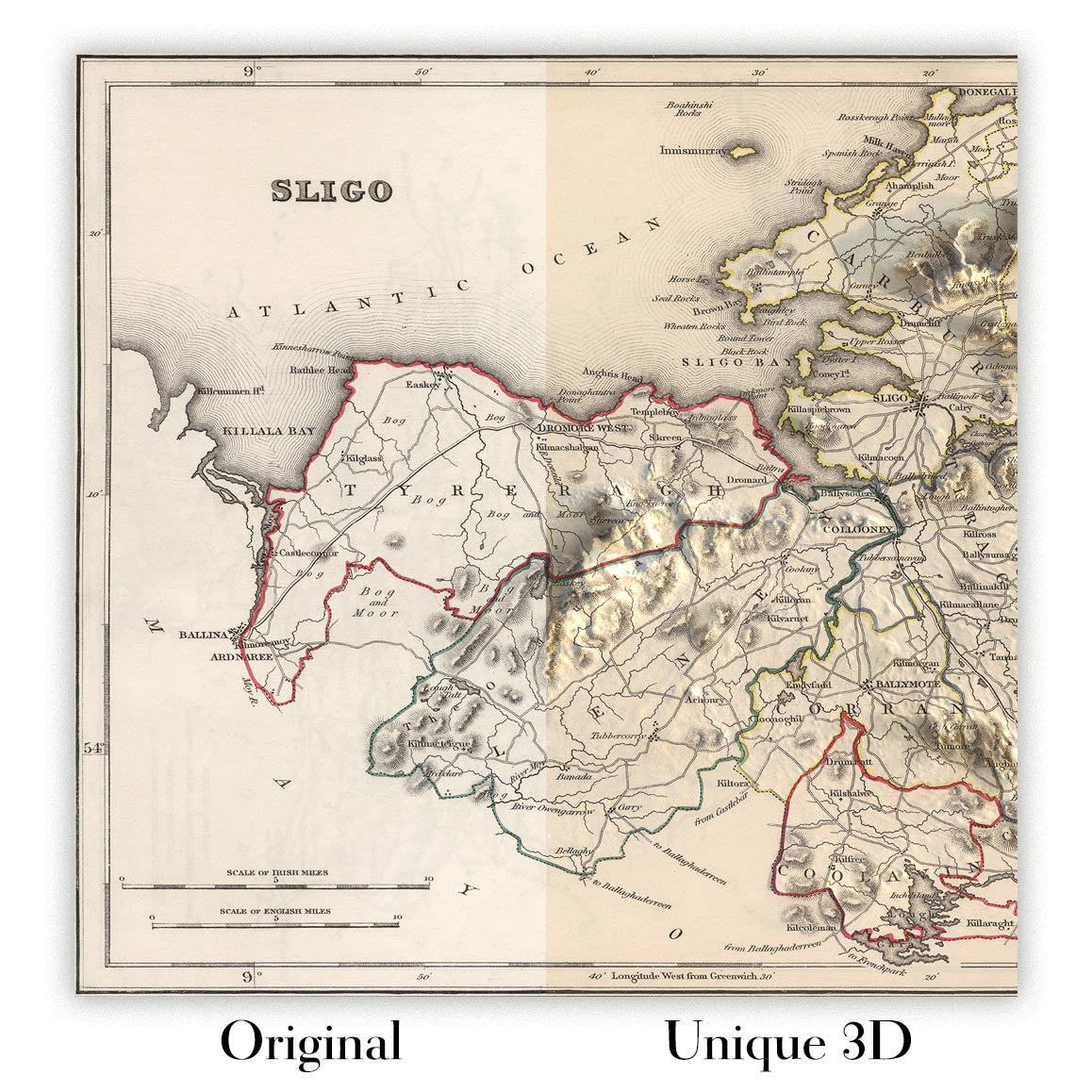
For something truly unique, this map is also available in "Unique 3D", our trademarked process that dramatically transforms the map so that it has a wonderful sense of depth. We combine the original map with detailed topography and elevation data, so that mountains and the terrain really "pop". For more info and examples of 3D maps, check my Unique 3D page.
Für die meisten Bestellungen beträgt die Lieferzeit etwa 3 Werktage. Personalisierte und maßgeschneiderte Produkte benötigen länger, da ich die Personalisierung durchführen und sie Ihnen zur Genehmigung zusenden muss, was normalerweise 1 oder 2 Tage dauert.
Bitte beachten Sie, dass sehr große gerahmte Bestellungen in der Regel länger für die Herstellung und Lieferung benötigen.
Wenn Sie möchten, dass Ihre Bestellung bis zu einem bestimmten Datum ankommt, bitte kontaktieren Sie mich, bevor Sie bestellen, damit wir den besten Weg finden können, um sicherzustellen, dass Sie Ihre Bestellung rechtzeitig erhalten.
Ich drucke und rahme Karten und Kunstwerke in 23 Ländern weltweit. Das bedeutet, dass Ihre Bestellung lokal gefertigt wird, was die Lieferzeit verkürzt und sicherstellt, dass sie während der Lieferung nicht beschädigt wird. Sie zahlen nie Zoll oder Einfuhrgebühren, und wir stoßen weniger CO2 in die Luft aus.
Alle meine Karten und Kunstdrucke sind gut verpackt und werden in einem robusten Rohr versendet, wenn sie ungerahmt sind, oder von Schaum umgeben, wenn sie gerahmt sind.
Ich versuche, alle Bestellungen innerhalb von 1 oder 2 Tagen nach Erhalt Ihrer Bestellung zu versenden, obwohl einige Produkte (wie Gesichtsmasken, Tassen und Tragetaschen) länger zur Herstellung benötigen können.
Wenn Sie Express-Lieferung an der Kasse auswählen, priorisieren wir Ihre Bestellung und versenden sie per 1-Tages-Kurier (Fedex, DHL, UPS, Parcelforce).
Nächster Tag Lieferung ist auch in einigen Ländern verfügbar (USA, UK, Singapur, VAE), aber bitte versuchen Sie, früh am Tag zu bestellen, damit wir es rechtzeitig versenden können.
Lesen Sie meinen vollständigen Leitfaden zur Lieferung und lokalen Produktion
Mein Standardrahmen ist ein Galerie-Stil-Rahmen aus schwarzem Eschenholz. Er ist einfach und sieht ziemlich modern aus. Mein Standardrahmen ist etwa 20 mm (0,8 Zoll) breit.
Ich verwende super-klares Acryl (Plexiglas/Acrylt) für das Glas des Rahmens. Es ist leichter und sicherer als Glas – und es sieht besser aus, da die Reflexion geringer ist.
Sechs Standardrahmenfarben sind kostenlos erhältlich (schwarz, dunkelbraun, dunkelgrau, Eiche, weiß und antikgold).
Die meisten Karten, Kunstwerke und Illustrationen sind auch als gerahmte Leinwand erhältlich. Wir verwenden matte (nicht glänzende) Baumwollleinwand, spannen sie über einen nachhaltig beschafften Buchenrahmen und 'schweben' dann das Stück innerhalb eines Holzrahmens. Das Endergebnis ist ziemlich schön, und es gibt keine Verglasung, die im Weg ist.
Alle Rahmen werden "bereit zum Aufhängen" geliefert, entweder mit einer Schnur oder Halterungen auf der Rückseite. Sehr große Rahmen haben schwere Aufhängeplatten und/oder eine Montageschiene. Wenn Sie Fragen haben, können Sie bitte Kontakt aufnehmen.
Sehen Sie sich einige Beispiele meiner gerahmten Karten und gerahmten Leinwandkarten an.
Alternativ kann ich auch alte Karten und Kunstwerke auf Leinwand, Schaumstoffplatten, Baumwollrag und andere Materialien liefern.
Wenn Sie Ihre Karte oder Ihr Kunstwerk selbst rahmen möchten, lesen Sie bitte zuerst meinen Größenleitfaden.
Einige meiner alten Karten sind jetzt als gerahmte Leinwände erhältlich. Bitte kontaktiere mich, wenn du eine Größe bestellen möchtest, die in meinem Shop nicht verfügbar ist.
Leinwand alte Karten sind eine interessante Alternative zu konventionell gerahmten Karten. Je nach deinem persönlichen Geschmack und der Raumdekoration können Leinwandkarten etwas mehr „herausstechen“ als eine gerahmte Karte.
Meine Karten sind äußerst hochwertige Reproduktionen von Originalkarten.
Ich beziehe originale, seltene Karten aus Bibliotheken, Auktionshäusern und Privatsammlungen auf der ganzen Welt, restauriere sie in meiner Londoner Werkstatt und erstelle dann mit speziellen Giclée-Tinten und -Druckern wunderschöne Karten, die sogar noch besser aussehen als das Original.
Meine Karten werden auf säurefreiem, mattem Archivpapier (nicht glänzend) gedruckt, das sich sehr hochwertig anfühlt und fast wie Karton aussieht. Technisch gesehen beträgt das Papiergewicht/die Papierdicke 10mil/200g/m². Es eignet sich perfekt zum Einrahmen.
Ich drucke mit UV-lichtbeständigen Ultrachrome-Giclée-Pigmenttinten von Epson – einige der besten Tinten, die Sie finden können.
Ich kann auch machen Karten auf Leinwand, Baumwolllappen und andere exotische Materialien.
Erfahren Sie mehr über The Unique Maps Co.
Kartenpersonalisierung
Wenn Sie nach dem perfekten Geschenk zum Jahrestag oder zur Einweihung suchen, kann ich Ihre Karte personalisieren, um sie wirklich einzigartig zu machen. Ich kann beispielsweise eine kurze Nachricht hinzufügen, einen wichtigen Ort hervorheben oder das Wappen Ihrer Familie hinzufügen.
Die Möglichkeiten sind nahezu unbegrenzt. Bitte sehen Sie sich meine Kartenpersonalisierungsseite für einige wunderbare Beispiele dessen, was möglich ist.
Um eine personalisierte Karte zu bestellen, wählen Sie „Personalisieren Sie Ihre Karte“, bevor Sie sie in den Warenkorb legen.
In Kontakt kommen wenn Sie nach komplexeren Anpassungen und Personalisierungen suchen.
Kartenalterung
Im Laufe der Jahre wurde ich von Kunden hunderte Male gefragt, ob sie eine Karte kaufen könnten, die noch älter.
Nun, jetzt können Sie das, indem Sie „Alter“ auswählen, bevor Sie eine Karte in Ihren Warenkorb legen.
Alle Produktfotos, die Sie auf dieser Seite sehen, zeigen die Karte in ihrer Originalform. So sieht die Karte heute aus.
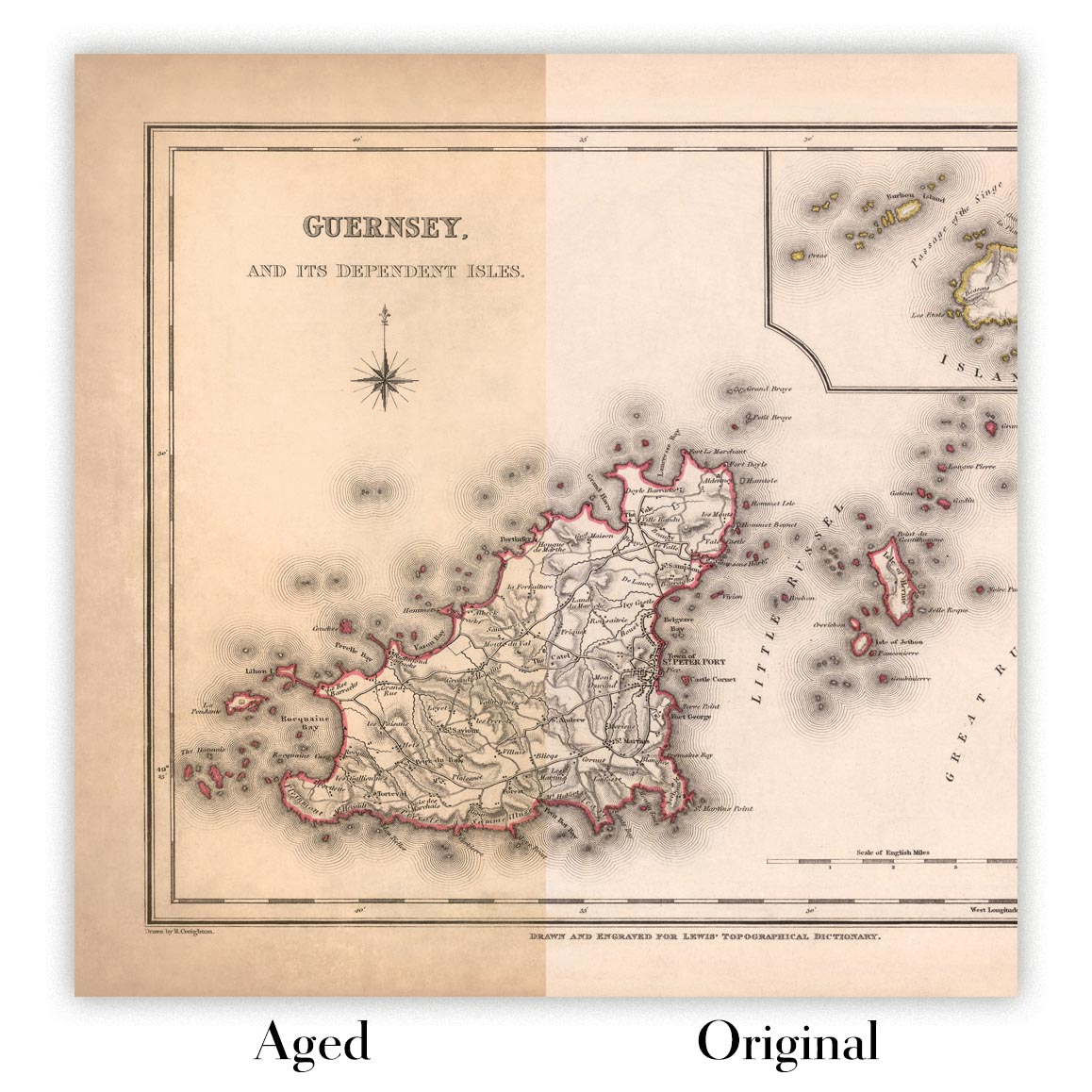
Wenn Sie „Gealtert“ auswählen, werde ich Ihre Karte von Hand altern lassen. Dazu verwende ich ein spezielles und einzigartiges Verfahren, das ich durch jahrelanges Studium alter Karten und Gespräche mit Forschern zum Verständnis der Chemie alternder Papiere entwickelt habe, und natürlich ... viel Übung!
Wenn Sie sich nicht sicher sind, bleiben Sie bei der Originalfarbe der Karte. Wenn Sie etwas Dunkleres und älter Wenn Sie auf der Suche sind, entscheiden Sie sich für „Aged“.
Sehen Sie einige erstaunliche Beispiele für gealterte Karten.
Wenn Sie aus irgendeinem Grund mit Ihrer Bestellung nicht zufrieden sind, kontaktieren Sie mich für eine unkomplizierte Rückerstattung. Bitte sehen Sie sich unsere Rückgabe- und Rückerstattungsrichtlinien für weitere Informationen an.
Ich bin sehr zuversichtlich, dass Ihnen Ihre restaurierte Karte oder Kunstdruck gefallen wird. Ich mache das seit 1984. Ich bin ein 5-Sterne Etsy-Verkäufer. Ich habe Zehntausende von Karten und Kunstdrucken verkauft und habe über 5.000 echte 5-Sterne-Bewertungen.
Ich verwende einen einzigartigen Prozess, um Karten und Kunstwerke zu restaurieren, der extrem zeitaufwendig und arbeitsintensiv ist. Die Suche nach den Originalkarten und Illustrationen kann Monate dauern. Ich benutze modernste und unglaublich teure Technologie, um sie zu scannen und wiederherzustellen. Daher garantiere ich, dass meine Karten und Kunstdrucke eine Klasse für sich sind - deshalb kann ich eine unkomplizierte Rückerstattung anbieten.
Fast alle meine Karten und Kunstdrucke sehen in großen Größen (200 cm, 6,5 Fuß+) erstaunlich aus und ich kann sie Ihnen auch gerahmt und über einen speziellen Übergrößen-Kurier liefern. Kontaktieren Sie mich, um Ihre speziellen Bedürfnisse zu besprechen.
Or try searching for something!


