


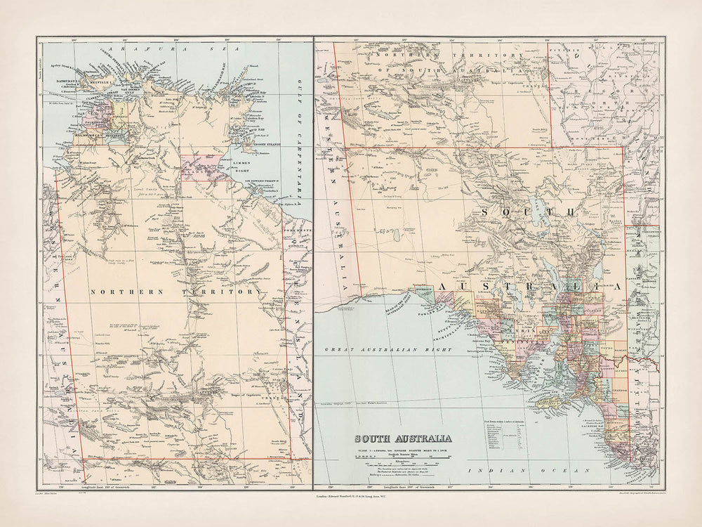


Alte Landkarte von Südaustralien von Stanford, 1904: Adelaide, Murray River, Lake Eyre, Flinders Ranges, Eisenbahnen
Kaufe 2, Erhalte 1 Kostenlos
Wenn Sie 2 Artikel in Ihren Warenkorb legen, können Sie ein drittes Produkt kostenlos hinzufügen.
Dies gilt für alle Karten und Kunstwerke, einschließlich individuell gestalteter und personalisierter Stücke. Sie können 3 von derselben Sache oder 3 verschiedene Dinge bestellen.
Das entspricht einem Rabatt von 33 %, der in diesem Jahr der größte Rabatt in meinem Shop sein wird.
Bitte nutzen Sie das Angebot und dekorieren Sie Ihre Wände mit schönen Karten und Kunst!
Kontaktieren Sie mich, wenn Sie Fragen haben.

-
![]() Handmade in the UK (we're based in London)
Handmade in the UK (we're based in London)
-
FREE worldwide delivery in 2-3 days ⓘ
Free delivery in 2-3 days
Your map should be delivered in 2-3 working days with free delivery, worldwide.
Deliveries over the Christmas and New Year period may be slightly delayed, as couriers and postal services catch up with a huge backlog of packages.
We make maps by hand locally in 23 countries. If you're buying a gift for someone in another country, we will make the map locally to them.
You will never pay import tax or customs duty.
Express delivery is available at checkout which can reduce the delivery time to 1-2 days.
Please note that personalised maps, and larger framed maps, can take longer to produce and deliver.
If you need your order to arrive by a certain date, contact me and we can discuss your options.
-
FREE gift preview
ⓘ
Digital gift preview
After you complete your order, you can send a beautiful digital preview to the gift recipient. Just provide their email address and we'll do the rest. (Their email address will not be stored or used for any other purpose.)
This is perfect if you're concerned that your order might not arrive in time.
You can also buy a real non-expiring gift card, and email it directly to the recipient, so they can buy their own map or artwork.
-
90 day money back guarantee
ⓘ
90 Tage für Rückgabe und Rückerstattung
Produkte können innerhalb von 90 Tagen für eine vollständige Rückerstattung oder einen Umtausch gegen ein anderes Produkt zurückgegeben werden.
Für personalisierte und maßgefertigte Artikel können wir Ihnen möglicherweise einen Gutschein oder eine nicht ablaufende Geschenkkarte anbieten, da wir personalisierte Bestellungen nicht weiterverkaufen können.
Wenn Sie Fragen haben, kontaktieren Sie uns. Für weitere Informationen siehe unsere vollständige Rückgabe- und Umtauschrichtlinie.

My maps are rare, museum-grade, restored old maps sourced from libraries, auction houses and private collections across the globe.
Framing & free personalisation available
1. Select your size
Click here to order a custom size.
2. Frame & personalise your map
Make your map unique with framing, hand-drawn customisation, vintage ageing, pop art text, unique 3D styling and more.


Geschenkmitteilung & individuelle Ausführung

Wenn Sie eine Geschenkmitteilung oder eine Ausführung (Puzzle, Aluminiumplatte usw.) hinzufügen möchten, die hier nicht verfügbar ist, geben Sie dies bitte in der "Bestellnotiz" beim Checkout an.
Jede Bestellung wird individuell angefertigt. Wenn Sie die Größe leicht anpassen oder auf einem ungewöhnlichen Material drucken lassen möchten, lassen Sie es uns einfach wissen. Wir haben im Laufe der Jahre Tausende von individuellen Bestellungen bearbeitet, daher gibt es (fast) nichts, was wir nicht bewältigen können.
Sie können uns auch kontaktieren, bevor Sie bestellen, wenn Sie möchten!

- Handmade locally. No import duty or tax
- FREE worldwide delivery
- Love it or your money back (90 days)
- Questions? WhatsApp me any time
Own a piece of history
5,000+ 5 star reviews


Betreten Sie die lebendige Welt von Edward Stanfords kartografischem Meisterwerk mit der Karte von 1904 mit dem Titel „South Australia.“ Dieses außergewöhnliche Stück ist mehr als ein geografisches Dokument – es ist ein Fenster in die koloniale Landschaft des frühen 20. Jahrhunderts, wo die Ambitionen von Entdeckern, Siedlern und Verwaltungsbeamten auf dem weiten australischen Kontinent zusammenkamen. Stanfords Karte, mit ihrem ursprünglichen, eindrucksvollen Titel, fängt das Wesen von Südaustralien in einem entscheidenden Moment ein, nur wenige Jahre nach der Föderation. Sie ist ein Zeugnis für die Präzision und Kunstfertigkeit britischer Kartographie, entworfen, um zu leiten, zu informieren und zu inspirieren, diejenigen, die die sich entwickelnde Identität der Region verstehen möchten.
Edward Stanford, ein Titan der viktorianischen und edwardianischen Kartographie, erbte und hob das Erbe von John Arrowsmith hervor, dessen Platten er nach Arrowsmiths Tod erwarb. Stanfords Londoner Atlas, aus dem diese Karte stammt, wurde zum Goldstandard für geografische Referenzen in der englischsprachigen Welt. Durch akribische Farblithografie verlieh Stanford jedem Landkreis lebendige Farben, während er Hachuren und Höhenpunkte einsetzte, um das Terrain mit bemerkenswerter Klarheit darzustellen. Seine Karten werden nicht nur für ihre technische Genauigkeit, sondern auch für ihre Eleganz und Lesbarkeit gefeiert, Eigenschaften, die sie zu beständigen Objekten der Faszination und des Studiums gemacht haben.
Das Design der Karte ist eine harmonische Mischung aus politischen und physischen Details. Landkreise sind kühn abgegrenzt, ihre Grenzen in auffälligen Farben dargestellt, die jede Jurisdiktion unterscheiden. Große Flüsse, wie der mächtige Murray, schlängeln sich durch die Landschaft, während weite Salzwasserseen – Lake Eyre und Lake Torrens – das trockene Innere punctuieren. Die Flinders Ranges erheben sich aus den Ebenen, ihre rauen Konturen mit zarten Hachuren dargestellt, und die beiden Arme des Spencer Gulf und des Gulf St Vincent umarmen das fruchtbare Küstenland. Küstenmerkmale wie Kangaroo Island und die dramatischen Umrisse der Yorke- und Eyre-Halbinseln vervollständigen ein Porträt eines Landes, das sowohl ungezähmt als auch zunehmend miteinander verbunden ist.
Stanfords Karte von 1904 ist ein Chronik der aufstrebenden Infrastruktur Südaustraliens. Sie verfolgt das Netz von Telegraphenleitungen und Eisenbahnen, das entfernte Siedlungen in ein aufkeimendes Netzwerk von Handel und Kommunikation einfügte. Straßen schlängeln sich zwischen Städten wie Adelaide, Mount Gambier und Port Augusta, während das große Inset der Nordterritoriums auf der Karte uns an die administrativen Bindungen erinnert, die einst diese weiten Regionen miteinander verbanden. Das Gitter von Breiten- und Längengrad, zusammen mit klar gekennzeichneten Grenzen zu New South Wales, Victoria und Western Australia, situieren Südaustralien innerhalb des breiteren Gewebes eines sich wandelnden Kontinents.
Über ihre unmittelbare Nützlichkeit hinaus steht diese Karte als historisches Artefakt von tiefgreifender Bedeutung. Sie fängt den Optimismus und die Komplexität einer Gesellschaft am Rande der Moderne ein, die die Anforderungen von Erkundung, Siedlung und Regierungsführung ausbalanciert. Während Nationalparks und Schutzgebiete noch nicht formell kartiert waren, ist die natürliche Pracht der Landschaft unübersehbar. Für Sammler, Historiker und Liebhaber kartografischer Kunst ist Edward Stanfords „South Australia“ eine Einladung, durch die Zeit zu reisen und die Konturen eines Landes nachzuvollziehen, dessen Geschichte sich noch entfaltet.
Städte und Orte auf dieser Karte
- Adelaide
- Mount Gambier
- Whyalla
- Port Augusta
- Port Pirie
- Murray Bridge
- Gawler
- Port Lincoln
- Victor Harbor
- Kadina
- Moonta
- Wallaroo
- Peterborough
- Clare
- Burra
- Kapunda
- Naracoorte
- Millicent
- Robe
- Penola
- Bordertown
- Kingston SE
- Cowell
- Tumby Bay
- Orroroo
- Jamestown
- Quorn
- Crystal Brook
- Snowtown
- Melrose
- Wilmington
- Riverton
- Balaklava
- Gladstone
- Laura
- Port Wakefield
- Eudunda
- Minlaton
- Yorketown
- Streaky Bay
- Elliston
- Kimba
- Ceduna
- Pinnaroo
- Lameroo
- Tailem Bend
- Mannum
- Morgan
- Renmark
- Berri
- Loxton
- Waikerie
- Barmera
- Tarcoola
- Darwin (kann als Palmerston oder Port Darwin bezeichnet werden)
- Katherine
- Tennant Creek
- Alice Springs (kann fehlen oder als Stuart bezeichnet werden)
- Borroloola
Bemerkenswerte Merkmale & Wahrzeichen
- Deutlich definierte Landkreisgrenzen in ganz Südaustralien, jeweils lebhaft farbcodiert
- Wichtige Flüsse einschließlich des Murray River, der prominent dargestellt ist
- Lake Eyre, ein bedeutender innerer Salzwassersee
- Lake Torrens, ein weiterer großer Salzwassersee
- Flinders Ranges, mit Hachuren dargestellt, um gebirgiges Terrain anzuzeigen
- Spencer Gulf, ein bedeutendes Gewässer an der Südküste
- Gulf St Vincent, der andere große Golf neben Adelaide
- Yorke Peninsula, klar zwischen den beiden Buchten umrissen
- Eyre Peninsula, westlich des Spencer Gulf
- Telegrafenleitungen und -routen, dargestellt mit gestrichelten oder durchgehenden Linien
- Eisenbahnen und vorgeschlagene Eisenbahnlinien, mit auffälligen Symbolen dargestellt
- Wichtige Straßenrouten, die wichtige Siedlungen und Regionen verbinden
- Die große Einlagekarte des Northern Territory, die seine Grenzen und wichtigen Merkmale zeigt
- Küstenmerkmale wie Kangaroo Island, die vor der Südküste dargestellt sind
- Hachuren, die gebirgige und hügelige Regionen veranschaulichen
- Die Grenze zu New South Wales, Victoria und Westaustralien deutlich markiert
- Zahlreiche Salzwasserseen und kleinere Binnengewässer
- Breiten- und Längengradgitter zur genauen Standortreferenzierung
Historischer und gestalterischer Kontext
- Erstellungsdatum: 1904
- Kartenmacher/Verleger: Edward Stanford, ein renommierter britischer Kartograf und Verleger, der das Erbe von John Arrowsmith fortsetzte
- Ursprung: Teil von Stanfords Londoner Atlas, der den einflussreichen Londoner Atlas von John Arrowsmith nach dessen Tod 1858 ablöste
- Atlasgeschichte: Erstmals 1887 herausgegeben, mit nachfolgenden aktualisierten Ausgaben in 1893, 1896, 1898, 1901 und der dritten Auflage 1904
- Drucktechnik: Vollfarb-Lithografie mit lebhaften Hervorhebungen der Landkreise
- Kartenstil: Detaillierte politische und physische Karte, die Landkreise, Siedlungen, Straßen, Eisenbahnen und Telegraphenleitungen zeigt
- Reliefdarstellung: Verwendet Hachuren und Punkt-Höhen, um Terrain und topografische Merkmale darzustellen
- Thematischer Inhalt: Hebt politische Grenzen (Landkreise), Verkehrsinfrastruktur (Straßen, Eisenbahnen, Telegraphen) und physische Geographie (Berge, Flüsse, Seen) hervor
- Historischer Kontext: Erfasst den Zustand von Südaustralien und dem Northern Territory, wie sie zu Beginn des 20. Jahrhunderts, kurz nach der Föderation (1901), verwaltet wurden
- Bedeutung: Bietet einen Einblick in die koloniale Verwaltung, Infrastrukturentwicklung und Erkundung zu einem entscheidenden Zeitpunkt in der australischen Geschichte
- Die Karte ist ein Beispiel für die britische imperialistische Kartographie, die sowohl die administrative Kontrolle als auch die Kartierungsprioritäten der Ära widerspiegelt
Bitte überprüfen Sie die Bilder, um sicherzustellen, dass eine bestimmte Stadt oder ein Ort auf dieser Karte angezeigt wird. Sie können uns auch kontaktieren und uns bitten, die Karte für Sie zu überprüfen.
Diese Karte sieht in jeder Größe großartig aus, aber ich empfehle immer, eine größere Größe zu wählen, wenn Sie Platz haben. So können Sie alle Details leicht erkennen.
Diese Karte sieht bis zu 70 Zoll (180 cm) fantastisch aus. Wenn Sie nach einer größeren Karte suchen, bitte kontaktieren Sie uns.
Bitte beachten Sie: Die Beschriftungen auf dieser Karte sind schwer zu lesen, wenn Sie eine Karte bestellen, die 16 Zoll (40 cm) oder kleiner ist. Die Karte ist immer noch sehr attraktiv, aber wenn Sie die Karte leicht lesen möchten, kaufen Sie bitte eine größere Größe.
Das Modell auf den Listing-Bildern hält die 18x24 Zoll (45x60 cm) Version dieser Karte.
Das fünfte Listing-Bild zeigt ein Beispiel für meinen Personalisierungsservice für Karten.
Wenn Sie nach etwas etwas anderem suchen, schauen Sie sich meine Sammlung der besten alten Karten an, um zu sehen, ob Ihnen etwas anderes ins Auge fällt.
Bitte kontaktieren Sie mich, um zu überprüfen, ob ein bestimmter Standort, Wahrzeichen oder Merkmal auf dieser Karte angezeigt wird.
Dies wäre ein wunderbares Geschenk zum Geburtstag, Weihnachten, Vatertag, Abschied von der Arbeit, Jubiläum oder Einweihung für jemanden aus den von dieser Karte abgedeckten Gebieten.
Diese Karte ist als Giclée-Druck auf säurefreiem, archivfestem mattem Papier erhältlich, oder Sie können sie gerahmt kaufen. Der Rahmen ist ein schöner, einfacher schwarzer Rahmen, der zu den meisten Ästhetiken passt. Bitte kontaktieren Sie uns, wenn Sie eine andere Rahmenfarbe oder -material wünschen. Meine Rahmen sind mit superklarem museumsgüte Acryl (Plexiglas/Acrylt) verglast, das deutlich weniger reflektierend ist als Glas, sicherer ist und immer in perfektem Zustand ankommt.
This map is also available as a float framed canvas, sometimes known as a shadow gap framed canvas or canvas floater. The map is printed on artist's cotton canvas and then stretched over a handmade box frame. We then "float" the canvas inside a wooden frame, which is available in a range of colours (black, dark brown, oak, antique gold and white). This is a wonderful way to present a map without glazing in front. See some examples of float framed canvas maps and explore the differences between my different finishes.
For something truly unique, this map is also available in "Unique 3D", our trademarked process that dramatically transforms the map so that it has a wonderful sense of depth. We combine the original map with detailed topography and elevation data, so that mountains and the terrain really "pop". For more info and examples of 3D maps, check my Unique 3D page.
Für die meisten Bestellungen beträgt die Lieferzeit etwa 3 Werktage. Personalisierte und maßgeschneiderte Produkte benötigen länger, da ich die Personalisierung durchführen und sie Ihnen zur Genehmigung zusenden muss, was normalerweise 1 oder 2 Tage dauert.
Bitte beachten Sie, dass sehr große gerahmte Bestellungen in der Regel länger für die Herstellung und Lieferung benötigen.
Wenn Sie möchten, dass Ihre Bestellung bis zu einem bestimmten Datum ankommt, bitte kontaktieren Sie mich, bevor Sie bestellen, damit wir den besten Weg finden können, um sicherzustellen, dass Sie Ihre Bestellung rechtzeitig erhalten.
Ich drucke und rahme Karten und Kunstwerke in 23 Ländern weltweit. Das bedeutet, dass Ihre Bestellung lokal gefertigt wird, was die Lieferzeit verkürzt und sicherstellt, dass sie während der Lieferung nicht beschädigt wird. Sie zahlen nie Zoll oder Einfuhrgebühren, und wir stoßen weniger CO2 in die Luft aus.
Alle meine Karten und Kunstdrucke sind gut verpackt und werden in einem robusten Rohr versendet, wenn sie ungerahmt sind, oder von Schaum umgeben, wenn sie gerahmt sind.
Ich versuche, alle Bestellungen innerhalb von 1 oder 2 Tagen nach Erhalt Ihrer Bestellung zu versenden, obwohl einige Produkte (wie Gesichtsmasken, Tassen und Tragetaschen) länger zur Herstellung benötigen können.
Wenn Sie Express-Lieferung an der Kasse auswählen, priorisieren wir Ihre Bestellung und versenden sie per 1-Tages-Kurier (Fedex, DHL, UPS, Parcelforce).
Nächster Tag Lieferung ist auch in einigen Ländern verfügbar (USA, UK, Singapur, VAE), aber bitte versuchen Sie, früh am Tag zu bestellen, damit wir es rechtzeitig versenden können.
Lesen Sie meinen vollständigen Leitfaden zur Lieferung und lokalen Produktion
Mein Standardrahmen ist ein Galerie-Stil-Rahmen aus schwarzem Eschenholz. Er ist einfach und sieht ziemlich modern aus. Mein Standardrahmen ist etwa 20 mm (0,8 Zoll) breit.
Ich verwende super-klares Acryl (Plexiglas/Acrylt) für das Glas des Rahmens. Es ist leichter und sicherer als Glas – und es sieht besser aus, da die Reflexion geringer ist.
Sechs Standardrahmenfarben sind kostenlos erhältlich (schwarz, dunkelbraun, dunkelgrau, Eiche, weiß und antikgold).
Die meisten Karten, Kunstwerke und Illustrationen sind auch als gerahmte Leinwand erhältlich. Wir verwenden matte (nicht glänzende) Baumwollleinwand, spannen sie über einen nachhaltig beschafften Buchenrahmen und 'schweben' dann das Stück innerhalb eines Holzrahmens. Das Endergebnis ist ziemlich schön, und es gibt keine Verglasung, die im Weg ist.
Alle Rahmen werden "bereit zum Aufhängen" geliefert, entweder mit einer Schnur oder Halterungen auf der Rückseite. Sehr große Rahmen haben schwere Aufhängeplatten und/oder eine Montageschiene. Wenn Sie Fragen haben, können Sie bitte Kontakt aufnehmen.
Sehen Sie sich einige Beispiele meiner gerahmten Karten und gerahmten Leinwandkarten an.
Alternativ kann ich auch alte Karten und Kunstwerke auf Leinwand, Schaumstoffplatten, Baumwollrag und andere Materialien liefern.
Wenn Sie Ihre Karte oder Ihr Kunstwerk selbst rahmen möchten, lesen Sie bitte zuerst meinen Größenleitfaden.
Einige meiner alten Karten sind jetzt als gerahmte Leinwände erhältlich. Bitte kontaktiere mich, wenn du eine Größe bestellen möchtest, die in meinem Shop nicht verfügbar ist.
Leinwand alte Karten sind eine interessante Alternative zu konventionell gerahmten Karten. Je nach deinem persönlichen Geschmack und der Raumdekoration können Leinwandkarten etwas mehr „herausstechen“ als eine gerahmte Karte.
Meine Karten sind äußerst hochwertige Reproduktionen von Originalkarten.
Ich beziehe originale, seltene Karten aus Bibliotheken, Auktionshäusern und Privatsammlungen auf der ganzen Welt, restauriere sie in meiner Londoner Werkstatt und erstelle dann mit speziellen Giclée-Tinten und -Druckern wunderschöne Karten, die sogar noch besser aussehen als das Original.
Meine Karten werden auf säurefreiem, mattem Archivpapier (nicht glänzend) gedruckt, das sich sehr hochwertig anfühlt und fast wie Karton aussieht. Technisch gesehen beträgt das Papiergewicht/die Papierdicke 10mil/200g/m². Es eignet sich perfekt zum Einrahmen.
Ich drucke mit UV-lichtbeständigen Ultrachrome-Giclée-Pigmenttinten von Epson – einige der besten Tinten, die Sie finden können.
Ich kann auch machen Karten auf Leinwand, Baumwolllappen und andere exotische Materialien.
Erfahren Sie mehr über The Unique Maps Co.
Kartenpersonalisierung
Wenn Sie nach dem perfekten Geschenk zum Jahrestag oder zur Einweihung suchen, kann ich Ihre Karte personalisieren, um sie wirklich einzigartig zu machen. Ich kann beispielsweise eine kurze Nachricht hinzufügen, einen wichtigen Ort hervorheben oder das Wappen Ihrer Familie hinzufügen.
Die Möglichkeiten sind nahezu unbegrenzt. Bitte sehen Sie sich meine Kartenpersonalisierungsseite für einige wunderbare Beispiele dessen, was möglich ist.
Um eine personalisierte Karte zu bestellen, wählen Sie „Personalisieren Sie Ihre Karte“, bevor Sie sie in den Warenkorb legen.
In Kontakt kommen wenn Sie nach komplexeren Anpassungen und Personalisierungen suchen.
Kartenalterung
Im Laufe der Jahre wurde ich von Kunden hunderte Male gefragt, ob sie eine Karte kaufen könnten, die noch älter.
Nun, jetzt können Sie das, indem Sie „Alter“ auswählen, bevor Sie eine Karte in Ihren Warenkorb legen.
Alle Produktfotos, die Sie auf dieser Seite sehen, zeigen die Karte in ihrer Originalform. So sieht die Karte heute aus.
Wenn Sie „Gealtert“ auswählen, werde ich Ihre Karte von Hand altern lassen. Dazu verwende ich ein spezielles und einzigartiges Verfahren, das ich durch jahrelanges Studium alter Karten und Gespräche mit Forschern zum Verständnis der Chemie alternder Papiere entwickelt habe, und natürlich ... viel Übung!
Wenn Sie sich nicht sicher sind, bleiben Sie bei der Originalfarbe der Karte. Wenn Sie etwas Dunkleres und älter Wenn Sie auf der Suche sind, entscheiden Sie sich für „Aged“.
Sehen Sie einige erstaunliche Beispiele für gealterte Karten.
Wenn Sie aus irgendeinem Grund mit Ihrer Bestellung nicht zufrieden sind, kontaktieren Sie mich für eine unkomplizierte Rückerstattung. Bitte sehen Sie sich unsere Rückgabe- und Rückerstattungsrichtlinien für weitere Informationen an.
Ich bin sehr zuversichtlich, dass Ihnen Ihre restaurierte Karte oder Kunstdruck gefallen wird. Ich mache das seit 1984. Ich bin ein 5-Sterne Etsy-Verkäufer. Ich habe Zehntausende von Karten und Kunstdrucken verkauft und habe über 5.000 echte 5-Sterne-Bewertungen.
Ich verwende einen einzigartigen Prozess, um Karten und Kunstwerke zu restaurieren, der extrem zeitaufwendig und arbeitsintensiv ist. Die Suche nach den Originalkarten und Illustrationen kann Monate dauern. Ich benutze modernste und unglaublich teure Technologie, um sie zu scannen und wiederherzustellen. Daher garantiere ich, dass meine Karten und Kunstdrucke eine Klasse für sich sind - deshalb kann ich eine unkomplizierte Rückerstattung anbieten.
Fast alle meine Karten und Kunstdrucke sehen in großen Größen (200 cm, 6,5 Fuß+) erstaunlich aus und ich kann sie Ihnen auch gerahmt und über einen speziellen Übergrößen-Kurier liefern. Kontaktieren Sie mich, um Ihre speziellen Bedürfnisse zu besprechen.
Or try searching for something!


