


Antike Karte der Arabischen Halbinsel von Ptolemaios, 1482: Arabia Felix, Rotes Meer, Persischer Golf, Karmania
20% Rabatt auf 2 — 33% Rabatt auf 3
Fügen Sie beliebige zwei berechtigte Artikel zu Ihrem Warenkorb hinzu, um 20% Rabatt zu erhalten. Fügen Sie einen dritten hinzu und er ist kostenlos (entspricht 33% Rabatt, wenn Sie drei kaufen).
Kein Code erforderlich — das Angebot wird automatisch an der Kasse angewendet.
Gültig für alle Standardkarten und Kunstdrucke. Sie können beliebige Designs kombinieren.
Wenn Sie Artikel an mehrere Adressen versenden möchten, kontaktieren Sie uns bitte, bevor Sie Ihre Bestellung aufgeben.
Maßanfertigungen und individuelle Aufträge sind ausgeschlossen.
Kontaktieren Sie uns wenn Sie Fragen haben
-
![]() Handmade in the UK (we're based in London)
Handmade in the UK (we're based in London)

-
FREE worldwide delivery in 2-3 days ⓘ
Free delivery in 2-3 days
Your map should be delivered in 2-3 working days with free delivery, worldwide.
We make maps by hand locally in 23 countries. If you're buying a gift for someone in another country, we will make the map locally to them.
You will never pay import tax or customs duty.
Express delivery is available at checkout which can reduce the delivery time to 1-2 days.
Please note that personalised maps, and larger framed maps, can take longer to produce and deliver.
If you need your order to arrive by a certain date, contact me and we can discuss your options.
-
Complimentary gifting & design advice
ⓘ
Complimentary gifting & design advice
Available almost 24/7 on WhatsApp and email — we usually reply within minutes. We can help you:
- Choose a perfectly personalised gift
- Send a digital gift preview to the recipient
- Pick the ideal size for your wall
- Select the right finish and frame
Quick, friendly advice so you can order with confidence.
For last minute gifts, consider buying a digital gift card. We have over 5,000 maps and art prints to choose from.
-
90-day returns & 5-year guarantee
ⓘ
90 Tage für Rückgabe und Rückerstattung
Produkte können innerhalb von 90 Tagen für eine vollständige Rückerstattung oder einen Umtausch gegen ein anderes Produkt zurückgegeben werden.
Für personalisierte und maßgefertigte Artikel können wir Ihnen möglicherweise einen Gutschein oder eine nicht ablaufende Geschenkkarte anbieten, da wir personalisierte Bestellungen nicht weiterverkaufen können.
Wenn Sie Fragen haben, kontaktieren Sie uns. Für weitere Informationen siehe unsere vollständige Rückgabe- und Umtauschrichtlinie.

This is a museum-grade archival print from the original 1482 map — restored in our workshop and made to order on 220gsm archival matte paper or 400gsm artist's cotton canvas with pigment inks.
Professional framing & free personalisation available.
1. Choose a size
2. Frame & personalise your map
Make your map unique with framing, hand-drawn customisation, vintage ageing, pop art text, unique 3D styling and more.


Geschenkmitteilung & individuelle Ausführung

Wenn Sie eine Geschenkmitteilung oder eine Ausführung (Puzzle, Aluminiumplatte usw.) hinzufügen möchten, die hier nicht verfügbar ist, geben Sie dies bitte in der "Bestellnotiz" beim Checkout an.
Jede Bestellung wird individuell angefertigt. Wenn Sie die Größe leicht anpassen oder auf einem ungewöhnlichen Material drucken lassen möchten, lassen Sie es uns einfach wissen. Wir haben im Laufe der Jahre Tausende von individuellen Bestellungen bearbeitet, daher gibt es (fast) nichts, was wir nicht bewältigen können.
Sie können uns auch kontaktieren, bevor Sie bestellen, wenn Sie möchten!

- Handmade locally. No import duty or tax
- FREE worldwide delivery
- 90-day returns & 5-year product guarantee
- Questions? WhatsApp me any time
Own a piece of history
7,000+ 5 star reviews


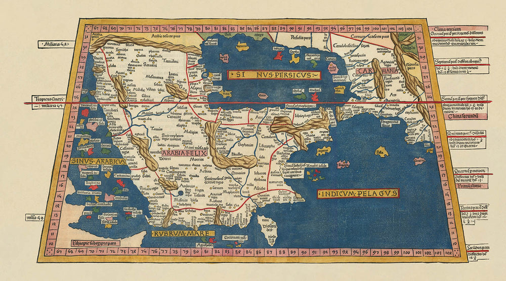
Betreten Sie die leuchtende Welt der Kartografie der Renaissance mit der außergewöhnlichen [Arabische Halbinsel] [Sexta Asie Tabula, Arabia Felix.], einer Karte, deren Name die legendären Länder und den wissenschaftlichen Ehrgeiz ihrer Zeit heraufbeschwört. Diese Karte, die 1482 für die gefeierte Ulmer Ausgabe von Ptolemäus' Geographia geschaffen wurde, ist eine wahre Rarität: die früheste Holzschnittdarstellung der Arabischen Halbinsel und ein krönendes Werk der Kartografie des 15. Jahrhunderts. Ihre Beschriftungen, verfasst in dem gelehrten Latein der damaligen Zeit, laden Sie ein, eine Welt zu erkunden, die sowohl vertraut als auch wunderbar neu interpretiert ist, in der die Grenzen des Wissens mit jeder Drehung der Presse neu gezogen wurden.
Der Genius hinter diesem Meisterwerk ist eine Vereinigung großer Geister. Die grundlegende Kartografie ist das Werk von Claudius Ptolemäus, dem antiken griechischen Universalgelehrten, dessen Geographia die Wissenschaft der Kartierung neu definierte. Der Verleger der Ulmer Ausgabe, Lienhart Holle, erweckte Ptolemäus' Vision zum ersten Mal nördlich der Alpen zum Leben, indem er die innovative Holzschnittdrucktechnik und die Kunstfertigkeit von Johannes Schnitzer einsetzte. Ihre Zusammenarbeit produzierte nicht nur eine Karte, sondern ein Kunstwerk—eines, das mit dem seltenen und kostbaren Pigment Lapislazuli, gewonnen aus den sagenumwobenen Minen Afghanistans, von Hand koloriert werden sollte.
Diese Karte ist ebenso reich an Details wie an Geschichte. Die Arabische Halbinsel—hier bekannt als Arabia Felix—nimmt einen zentralen Platz ein, umgeben von der azurblauen Umarmung des Roten Meeres, des Golfs von Aden, des Arabischen Meeres, des Golfs von Oman und des Persischen Golfs. Die Küste ist mit Inseln gesprenkelt, und das Land selbst ist von einem Teppich aus Städten und politischen Regionen geprägt, die alle ein Zeugnis für die umfassende Gelehrsamkeit des Kartografen ablegen. Die Ränder der Karte erstrecken sich bis zu den alten Reichen von Äthiopien und Karmania und bieten einen Blick auf Afrika und Persien, wie sie von der Renaissance-Europa verstanden wurden.
Ein markantes Merkmal dieser Karte ist die bahnbrechende Verwendung eines Breiten- und Längengitters, eine kartografische Innovation, die auf Ptolemäus selbst zurückzuführen ist. Dieses geometrische Gerüst, kombiniert mit den kühnen Titeln und dekorativen Verzierungen des Holzschnitts, verleiht sowohl wissenschaftliche Strenge als auch ästhetische Anmut. Jedes Detail, von der Platzierung der Städte bis zur Beschriftung der Meere, spiegelt den intellektuellen Aufbruch einer Epoche wider, in der die Welt durch die Linse der klassischen Weisheit und der neuesten Drucktechnologie neu entdeckt wurde.
Historisch steht diese Karte an der Kreuzung von Entdeckung und Tradition. Sie entstand zu einer Zeit, als Europa sich wieder dem geografischen Wissen der Antike zuwandte, dank der Wiederentdeckung und lateinischen Übersetzung von Ptolemäus' Texten. Die Ulmer Ausgabe war ein monumentales Verlagsereignis, ihre Karten wurden von Gelehrten und Sammlern gleichermaßen begehrt. Heute wird die [Arabische Halbinsel] [Sexta Asie Tabula, Arabia Felix.] nicht nur wegen ihrer Seltenheit und Schönheit gefeiert, sondern auch wegen ihres nachhaltigen Einflusses auf die Kunst und Wissenschaft der Kartierung—ein wahres Juwel für den anspruchsvollen Sammler.
Bemerkenswerte Merkmale & Sehenswürdigkeiten
- Die Arabische Halbinsel (Arabia Felix) zentral und prominent dargestellt
- Umgebende Gewässer: Rotes Meer, Golf von Aden, Arabisches Meer, Golf von Oman und Persischer Golf (alle in Latein beschriftet)
- Zahlreiche Inseln rund um die Halbinsel illustriert
- Breiten- und Längengitter, das die Karte umrahmt
- Grenzen von Äthiopien (Afrika) und Karmania (Persien/Iran) an den Kartenrändern dargestellt
- Politische Einheiten und Regionen beschriftet (in Latein)
- Dekorative Holzschnitttitel für größere Landmassen und Gewässer
Historischer und gestalterischer Kontext
- Name der Karte: [Arabische Halbinsel] [Sexta Asie Tabula, Arabia Felix.]
- Erstellungsdatum: 1482
- Kartograf/Verleger: Claudius Ptolemaeus (ursprüngliche Kartografie), Lienhart Holle (Verleger, Ulmer Ausgabe), Holzschnitt von Johannes Schnitzer
- Quelle: 1482 Ulmer Ausgabe von Ptolemaeus' Geographia, der ersten Atlas, der nördlich der Alpen gedruckt wurde und die ersten illustrierten Holzschnittkarten enthält
- Druckinnovation: Erste Holzschnittdarstellung der Arabischen Halbinsel; Meere mit teurem Lapislazuli-Pigment gefärbt
- Sprache: Alle Beschriftungen sind in Latein, der Gelehrtensprache des 15. Jahrhunderts
- Kartenthemen: Politische und physische Geografie der Arabischen Halbinsel und umliegender Regionen
- Ausgabeunterscheidungen: Die erste Ausgabe von 1482 hat keinen gedruckten Titel über dem Kartenbild; Meere in Blau mit Lapislazuli gefärbt; die Neuauflage von 1486 hat einen gedruckten Titel und braune Meere
- Seltenheit: Der erste Zustand der Karte ist selten und sehr begehrt; aktueller Auktionspreis über 110.000 $
- Bedeutung: Berühmteste und am meisten gesuchte Karte des 15. Jahrhunderts der Arabischen Halbinsel; früheste Holzschnittkarte der Region
- Einfluss: Ptolemaeus' Geographia führte Breiten- und Längengrade, Kartenprojektion und Nordausrichtung in die europäische Kartografie zurück
- Manuskriptursprünge: Basierend auf einem Manuskript von Dominus Nicolaus Germanus, einem deutschen Benediktinermönch
- Bemerkenswert für: Die Absicht, koloriert zu werden, mit Anweisungen des Verlegers zur Verschönerung
Bitte überprüfen Sie die Bilder, um sicherzustellen, dass eine bestimmte Stadt oder ein Ort auf dieser Karte angezeigt wird. Sie können uns auch kontaktieren und fragen, ob wir die Karte für Sie überprüfen.
Diese Karte sieht in jeder Größe großartig aus, aber ich empfehle immer, eine größere Größe zu wählen, wenn Sie Platz haben. So können Sie alle Details leicht erkennen.
Diese Karte sieht bis zu 90 Zoll (230 cm) fantastisch aus. Wenn Sie nach einer größeren Karte suchen, bitte kontaktieren Sie uns.
Diese Karte ist breiter als die meisten Karten, was sie zu einem perfekten Blickfang über einem Kaminsims, Sofa oder Schreibtisch macht.
Das fünfte Bild zeigt ein Beispiel für meinen Personalisierungsservice für Karten.
Wenn Sie nach etwas etwas anderem suchen, schauen Sie sich meine Sammlung der besten alten Karten an, um zu sehen, ob etwas anderes Ihr Interesse weckt.
Bitte kontaktieren Sie mich, um zu überprüfen, ob ein bestimmter Standort, ein Wahrzeichen oder ein Merkmal auf dieser Karte angezeigt wird.
Dies wäre ein wunderbares Geschenk zum Geburtstag, Weihnachten, Vatertag, Abschied von der Arbeit, Jubiläum oder Einweihung für jemanden aus den von dieser Karte abgedeckten Gebieten.
Diese Karte ist als Giclée-Druck auf säurefreiem, archivarischem mattem Papier erhältlich, oder Sie können sie gerahmt kaufen. Der Rahmen ist ein schöner, einfacher schwarzer Rahmen, der zu den meisten Ästhetiken passt. Bitte kontaktieren Sie mich, wenn Sie eine andere Rahmenfarbe oder -material wünschen. Meine Rahmen sind mit superklarem, museumsglasähnlichem Acryl (Plexiglas/Acrylit) glasiert, das deutlich weniger reflektierend als Glas ist, sicherer und immer in perfektem Zustand ankommt.
This map is also available as a float framed canvas, sometimes known as a shadow gap framed canvas or canvas floater. The map is printed on artist's cotton canvas and then stretched over a handmade box frame. We then "float" the canvas inside a wooden frame, which is available in a range of colours (black, dark brown, oak, antique gold and white). This is a wonderful way to present a map without glazing in front. See some examples of float framed canvas maps and explore the differences between my different finishes.
For something truly unique, this map is also available in "Unique 3D", our trademarked process that dramatically transforms the map so that it has a wonderful sense of depth. We combine the original map with detailed topography and elevation data, so that mountains and the terrain really "pop". For more info and examples of 3D maps, check my Unique 3D page.
Für die meisten Bestellungen beträgt die Lieferzeit etwa 3 Werktage. Personalisierte und maßgeschneiderte Produkte benötigen länger, da ich die Personalisierung durchführen und sie Ihnen zur Genehmigung zusenden muss, was normalerweise 1 oder 2 Tage dauert.
Bitte beachten Sie, dass sehr große gerahmte Bestellungen in der Regel länger für die Herstellung und Lieferung benötigen.
Wenn Sie möchten, dass Ihre Bestellung bis zu einem bestimmten Datum ankommt, bitte kontaktieren Sie mich, bevor Sie bestellen, damit wir den besten Weg finden können, um sicherzustellen, dass Sie Ihre Bestellung rechtzeitig erhalten.
Ich drucke und rahme Karten und Kunstwerke in 23 Ländern weltweit. Das bedeutet, dass Ihre Bestellung lokal gefertigt wird, was die Lieferzeit verkürzt und sicherstellt, dass sie während der Lieferung nicht beschädigt wird. Sie zahlen nie Zoll oder Einfuhrgebühren, und wir stoßen weniger CO2 in die Luft aus.
Alle meine Karten und Kunstdrucke sind gut verpackt und werden in einem robusten Rohr versendet, wenn sie ungerahmt sind, oder von Schaum umgeben, wenn sie gerahmt sind.
Ich versuche, alle Bestellungen innerhalb von 1 oder 2 Tagen nach Erhalt Ihrer Bestellung zu versenden, obwohl einige Produkte (wie Gesichtsmasken, Tassen und Tragetaschen) länger zur Herstellung benötigen können.
Wenn Sie Express-Lieferung an der Kasse auswählen, priorisieren wir Ihre Bestellung und versenden sie per 1-Tages-Kurier (Fedex, DHL, UPS, Parcelforce).
Nächster Tag Lieferung ist auch in einigen Ländern verfügbar (USA, UK, Singapur, VAE), aber bitte versuchen Sie, früh am Tag zu bestellen, damit wir es rechtzeitig versenden können.
Lesen Sie meinen vollständigen Leitfaden zur Lieferung und lokalen Produktion
Mein Standardrahmen ist ein Galerie-Stil-Rahmen aus schwarzem Eschenholz. Er ist einfach und sieht ziemlich modern aus. Mein Standardrahmen ist etwa 20 mm (0,8 Zoll) breit.
Ich verwende super-klares Acryl (Plexiglas/Acrylt) für das Glas des Rahmens. Es ist leichter und sicherer als Glas – und es sieht besser aus, da die Reflexion geringer ist.
Sechs Standardrahmenfarben sind kostenlos erhältlich (schwarz, dunkelbraun, dunkelgrau, Eiche, weiß und antikgold).
Die meisten Karten, Kunstwerke und Illustrationen sind auch als gerahmte Leinwand erhältlich. Wir verwenden matte (nicht glänzende) Baumwollleinwand, spannen sie über einen nachhaltig beschafften Buchenrahmen und 'schweben' dann das Stück innerhalb eines Holzrahmens. Das Endergebnis ist ziemlich schön, und es gibt keine Verglasung, die im Weg ist.
Alle Rahmen werden "bereit zum Aufhängen" geliefert, entweder mit einer Schnur oder Halterungen auf der Rückseite. Sehr große Rahmen haben schwere Aufhängeplatten und/oder eine Montageschiene. Wenn Sie Fragen haben, können Sie bitte Kontakt aufnehmen.
Sehen Sie sich einige Beispiele meiner gerahmten Karten und gerahmten Leinwandkarten an.
Alternativ kann ich auch alte Karten und Kunstwerke auf Leinwand, Schaumstoffplatten, Baumwollrag und andere Materialien liefern.
Wenn Sie Ihre Karte oder Ihr Kunstwerk selbst rahmen möchten, lesen Sie bitte zuerst meinen Größenleitfaden.
Einige meiner alten Karten sind jetzt als gerahmte Leinwände erhältlich. Bitte kontaktiere mich, wenn du eine Größe bestellen möchtest, die in meinem Shop nicht verfügbar ist.
Leinwand alte Karten sind eine interessante Alternative zu konventionell gerahmten Karten. Je nach deinem persönlichen Geschmack und der Raumdekoration können Leinwandkarten etwas mehr „herausstechen“ als eine gerahmte Karte.
Meine Karten sind äußerst hochwertige Reproduktionen von Originalkarten.
Ich beziehe originale, seltene Karten aus Bibliotheken, Auktionshäusern und Privatsammlungen auf der ganzen Welt, restauriere sie in meiner Londoner Werkstatt und erstelle dann mit speziellen Giclée-Tinten und -Druckern wunderschöne Karten, die sogar noch besser aussehen als das Original.
Meine Karten werden auf säurefreiem, mattem Archivpapier (nicht glänzend) gedruckt, das sich sehr hochwertig anfühlt und fast wie Karton aussieht. Technisch gesehen beträgt das Papiergewicht/die Papierdicke 10mil/200g/m². Es eignet sich perfekt zum Einrahmen.
Ich drucke mit UV-lichtbeständigen Ultrachrome-Giclée-Pigmenttinten von Epson – einige der besten Tinten, die Sie finden können.
Ich kann auch machen Karten auf Leinwand, Baumwolllappen und andere exotische Materialien.
Erfahren Sie mehr über The Unique Maps Co.
Kartenpersonalisierung
Wenn Sie nach dem perfekten Geschenk zum Jahrestag oder zur Einweihung suchen, kann ich Ihre Karte personalisieren, um sie wirklich einzigartig zu machen. Ich kann beispielsweise eine kurze Nachricht hinzufügen, einen wichtigen Ort hervorheben oder das Wappen Ihrer Familie hinzufügen.
Die Möglichkeiten sind nahezu unbegrenzt. Bitte sehen Sie sich meine Kartenpersonalisierungsseite für einige wunderbare Beispiele dessen, was möglich ist.
Um eine personalisierte Karte zu bestellen, wählen Sie „Personalisieren Sie Ihre Karte“, bevor Sie sie in den Warenkorb legen.
In Kontakt kommen wenn Sie nach komplexeren Anpassungen und Personalisierungen suchen.
Kartenalterung
Im Laufe der Jahre wurde ich von Kunden hunderte Male gefragt, ob sie eine Karte kaufen könnten, die noch älter.
Nun, jetzt können Sie das, indem Sie „Alter“ auswählen, bevor Sie eine Karte in Ihren Warenkorb legen.
Alle Produktfotos, die Sie auf dieser Seite sehen, zeigen die Karte in ihrer Originalform. So sieht die Karte heute aus.
Wenn Sie „Gealtert“ auswählen, werde ich Ihre Karte von Hand altern lassen. Dazu verwende ich ein spezielles und einzigartiges Verfahren, das ich durch jahrelanges Studium alter Karten und Gespräche mit Forschern zum Verständnis der Chemie alternder Papiere entwickelt habe, und natürlich ... viel Übung!
Wenn Sie sich nicht sicher sind, bleiben Sie bei der Originalfarbe der Karte. Wenn Sie etwas Dunkleres und älter Wenn Sie auf der Suche sind, entscheiden Sie sich für „Aged“.
Sehen Sie einige erstaunliche Beispiele für gealterte Karten.
Wenn Sie aus irgendeinem Grund mit Ihrer Bestellung nicht zufrieden sind, kontaktieren Sie mich für eine unkomplizierte Rückerstattung. Bitte sehen Sie sich unsere Rückgabe- und Rückerstattungsrichtlinien für weitere Informationen an.
Ich bin sehr zuversichtlich, dass Ihnen Ihre restaurierte Karte oder Kunstdruck gefallen wird. Ich mache das seit 1984. Ich bin ein 5-Sterne Etsy-Verkäufer. Ich habe Zehntausende von Karten und Kunstdrucken verkauft und habe über 5.000 echte 5-Sterne-Bewertungen.
Ich verwende einen einzigartigen Prozess, um Karten und Kunstwerke zu restaurieren, der extrem zeitaufwendig und arbeitsintensiv ist. Die Suche nach den Originalkarten und Illustrationen kann Monate dauern. Ich benutze modernste und unglaublich teure Technologie, um sie zu scannen und wiederherzustellen. Daher garantiere ich, dass meine Karten und Kunstdrucke eine Klasse für sich sind - deshalb kann ich eine unkomplizierte Rückerstattung anbieten.
Fast alle meine Karten und Kunstdrucke sehen in großen Größen (200 cm, 6,5 Fuß+) erstaunlich aus und ich kann sie Ihnen auch gerahmt und über einen speziellen Übergrößen-Kurier liefern. Kontaktieren Sie mich, um Ihre speziellen Bedürfnisse zu besprechen.
Or try searching for something!


