


Rare Renaissance Map of the Arabian Peninsula by Berlinghieri & Ptolemy, 1482: Saudi, UAE, Qatar, Oman
The Collector’s Offer
Choose two eligible works and receive 20% off both. Choose three and the lowest-priced one is complimentary, a maximum saving of 33%.
Mix and match eligible standard maps and fine-art prints. No code is required; the offer is applied automatically at checkout.
Standard made-to-order configurations are included. Bespoke sizes, personalised designs and commissioned work are excluded.
Need delivery to different addresses? Contact us before ordering.The Collector’s Offer
Choose two eligible works and receive 20% off both. Choose three and the lowest-priced one is complimentary, a maximum saving of 33%.
Mix and match eligible standard maps and fine-art prints. No code is required; the offer is applied automatically at checkout.
Standard made-to-order configurations are included. Bespoke sizes, personalised designs and commissioned work are excluded.
Need delivery to different addresses? Contact us before ordering. Restored in London • Made in the UK

Restored from the original 1482 map and printed to museum-grade archival standards. Read the story behind this map
Choose your size
Choose your finish


(More info)
Gift message & custom finish

If you want to add a gift message, or a finish (jigsaw, aluminium board, etc.) that is not available here, please request it in the "order note" when you check out.
Every order is custom made, so if you need the size adjusted slightly, or printed on an unusual material, just let us know. We've done thousands of custom orders over the years, so there's (almost) nothing we can't manage.
You can also contact us before you order, if you prefer!

- Made locally for fast, safe delivery
- No import duty or hidden fees
- Need advice? Call us or message on WhatsApp
Own a piece of history
8,000+ five-star reviews


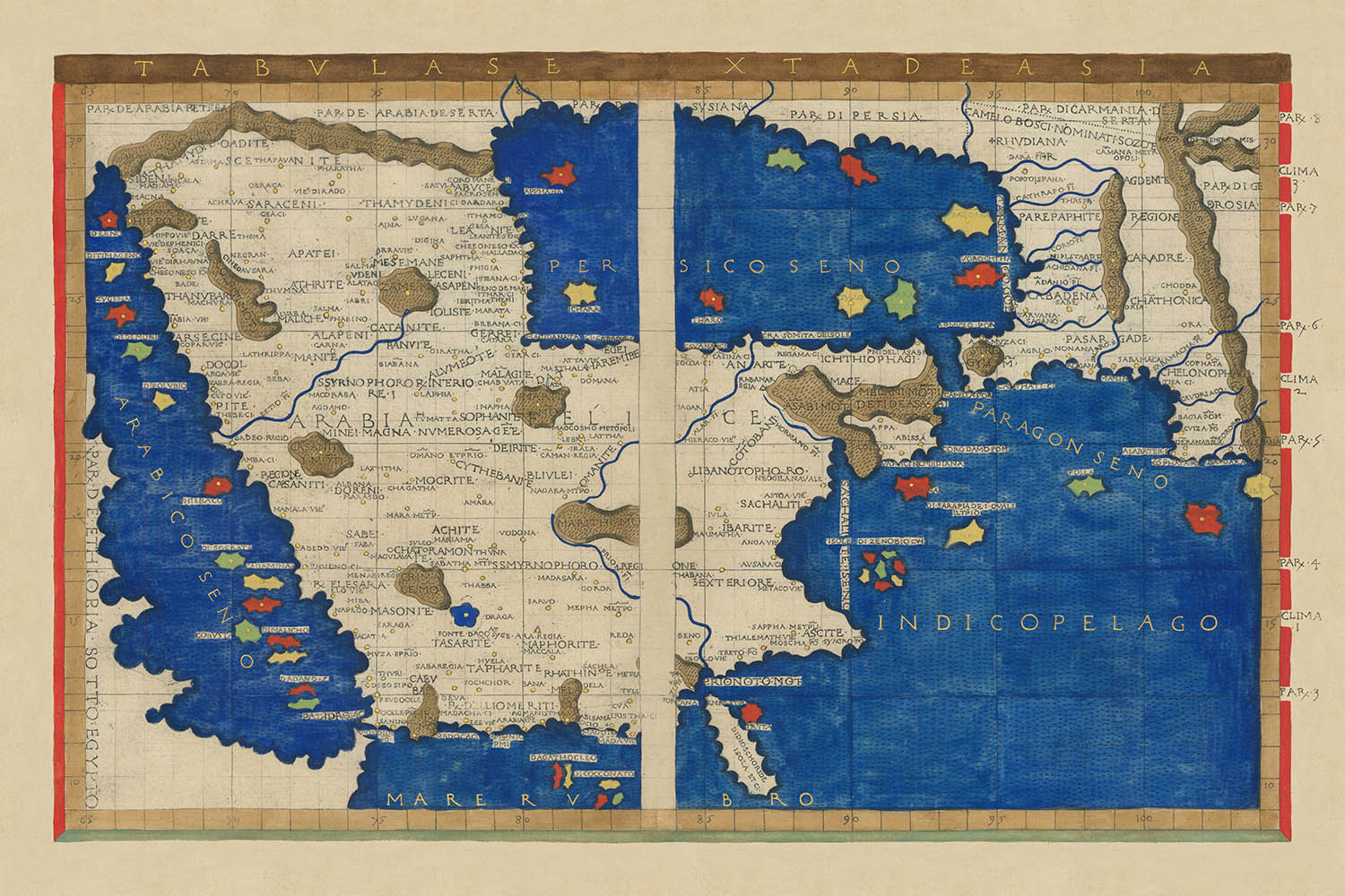
Step into the world of Renaissance discovery with the extraordinary (Arabian Peninsula) Tabula Sexta de Asia, a masterwork of early cartography first...
Continue readingStep into the world of Renaissance discovery with the extraordinary (Arabian Peninsula) Tabula Sexta de Asia, a masterwork of early cartography first printed in Florence in 1482. This rare and evocative map is the creation of Francesco Berlinghieri, a Florentine innovator whose daring approach redefined the boundaries of geographical knowledge. Drawing upon the ancient wisdom of Claudius Ptolemy and supplementing it with contemporary sources, Berlinghieri’s map stands apart as a vivid testament to the curiosity and ambition of the age. The Tabula Sexta de Asia is more than a geographical record; it is a visual narrative, capturing the imagination of explorers and scholars alike as they sought to understand the vast and mysterious Arabian Peninsula.
Berlinghieri’s vision was both scholarly and artistic. Unlike his contemporaries, he imbued his maps with dynamic coastlines and fluid mountain ranges, reflecting a world alive with movement and possibility. The Arabian Peninsula emerges here in a distinctly Ptolemaic form, its contours stretched and shaped by the limitations and aspirations of classical knowledge. Yet, within this framework, Berlinghieri’s artistry shines: rivers snake from central massifs to distant shores, archipelagos cluster near the Strait of Hormuz, and the coastlines of the Red Sea and Persian Gulf undulate with an almost painterly grace. This is a map where myth and reality intermingle, where the known world meets the legendary.
Among the map’s most captivating features are its depictions of the Holy Cities—Mecca (Macoraba) and Medina (Lathrippa)—set amidst stylized mountains and rivers, their positions hinting at the profound religious and commercial significance they held even in antiquity. Along the Red Sea, the bustling port of Jeddah (Badeo Regio) and the northern harbor of Yanbu are rendered with remarkable fidelity, while the fabled interior, the Rub al-Khali or Empty Quarter, is imaginatively filled with conjectural towns, rivers, and mountain ranges. Here, the boundaries between fact and legend blur, echoing the stories and speculations of sailors and traders who skirted Arabia’s uncharted heart.
The map’s eastern reaches offer an early, tantalizing glimpse of regions that would become modern Qatar and the United Arab Emirates. Ancient toponyms such as Catara and Chabuata stand as some of the earliest cartographic representations of these now-vital centers, while the coastline’s distinctive scoops and bays evoke the dynamic interplay between land and sea. The inclusion of islands like Socotra and intricate archipelagos near the Strait of Hormuz further underscores Berlinghieri’s commitment to capturing both the physical and mythological geography of the Arabian world.
Francesco Berlinghieri’s legacy is that of a cartographic pioneer—one who dared to challenge convention by blending the mathematical rigor of Ptolemy with the artistic sensibilities of the Florentine Renaissance. His Tabula Sexta de Asia is a singular achievement, notable not only for its historical significance but also for its enduring beauty. To own this map is to possess a piece of the intellectual and artistic ferment that shaped the modern understanding of the world—a rare window into the imagination and ambition of the Renaissance, where every river, mountain, and coastline tells a story centuries in the making.
Cities and towns on this map
- Saudi Arabia
- Jeddah (Badeo Regio) – modern population: ~4.7 million
- Mecca (Macoraba) – modern population: ~2 million
- Medina (Lathrippa/Yathrib) – modern population: ~1.5 million
- Najran (Nagara) – modern population: ~600,000
- Al-Qatif (Magidanata, though misplaced on map) – modern population: ~500,000
-
Yanbu (Iabia-Vie/Iambia) – modern population: ~250,000
-
United Arab Emirates
- Abu Dhabi (Chabuata) – modern population: ~1.5 million
- Sharjah (Sacoa) – modern population: ~1.3 million
-
Jazīrat as Sīnīyah (Casina) – population: small, part of Umm Al Quwain
-
Qatar
-
Catara (Qatar/Doha region) – modern population: Doha ~2.4 million
-
Oman
- Bidbid (Vodona, misplaced in the map’s center) – modern population: ~20,000
-
Nizwa (near Bidbid) – modern population: ~70,000
-
Yemen
- Najran (Nagara, actually in Saudi Arabia but often associated with Yemen in ancient sources)
Notable Features & Landmarks
- Red Sea (Mare Rubrum)
- Persian Gulf (Sinus Persicus)
- Arabian Sea (Mare Erythraeum)
- Gulf of Aden (depicted)
- Alar Fl. (possibly Wadi Lamhah)
- Betio Fl. (corresponds to Wadi Fa’idah or Wadi Fayd)
- Prion Fl. (mythological, possibly the Pishon River)
- Central massif/mountain ranges depicted in stylized form
- Mountain chains running through the peninsula
- Socotra (large island off southern Arabia)
- String of islands in the Red Sea
- Archipelago-like features near the Strait of Hormuz
- Labeled regions: Arabia Felix, Arabia Petrea, Arabia Deserta
- “SARACENI” labeled in the northern desert
- Dynamic, stylized coastlines with bays and inlets, especially along the Gulf and Red Sea
Historical and design context
- Original title: (Arabian Peninsula) Tabula Sexta de Asia
- Created by Francesco Berlinghieri in Florence, 1482, based on the work of Claudius Ptolemy
- Among the earliest printed maps to depict the Arabian Peninsula in a recognizable form
- Part of Berlinghieri’s innovative atlas Septe Giornate della Geographia, notable for using multiple map projections and sources beyond Ptolemy
- Artistic map with dynamic coastlines, fluid mountain ranges, and stylized rivers
- Fills the Arabian interior (Empty Quarter/Rub al-Khali) with conjectural and mythological features, reflecting limited knowledge of the region at the time
- Shows both ancient and mythological features, including the earliest faint depictions of Qatar and the United Arab Emirates
- Blends classical knowledge, medieval legend, and Renaissance innovation
- The “first state” of the map, confirmed by specific textual features (“PAR DE ARABIA PETREA” and “SARACENI” without overprinting)
- Important for the study of early cartography and the transmission of geographic knowledge from antiquity to the Renaissance
Please double check the images to make sure that a specific town or place is shown on this map. You can also get in touch and ask us to check the map for you.
This map looks great at every size, but I always recommend going for a larger size if you have space. That way you can easily make out all of the details.
This map looks amazing at sizes all the way up to 90in (230cm). If you are looking for a larger map, please get in touch.
The model in the listing images is holding the 24x36in (60x90cm) version of this map.
The fifth listing image shows an example of my map personalisation service.
If you’re looking for something slightly different, check out my collection of the best old maps to see if something else catches your eye.
Please contact me to check if a certain location, landmark or feature is shown on this map.
This would make a wonderful birthday, Christmas, Father's Day, work leaving, anniversary or housewarming gift for someone from the areas covered by this map.
This map is available as a giclée print on acid free archival matte paper, or you can buy it framed. The frame is a nice, simple black frame that suits most aesthetics. Please get in touch if you'd like a different frame colour or material. My frames are glazed with super-clear museum-grade acrylic (perspex/acrylite), which is significantly less reflective than glass, safer, and will always arrive in perfect condition.
This map is also available as a float framed canvas, sometimes known as a shadow gap framed canvas or canvas floater. The map is printed on artist's cotton canvas and then stretched over a handmade box frame. We then "float" the canvas inside a wooden frame, which is available in a range of colours (black, dark brown, oak, antique gold and white). This is a wonderful way to present a map without glazing in front. See some examples of float framed canvas maps and explore the differences between my different finishes.
For something truly unique, this map is also available in "Unique 3D", our trademarked process that dramatically transforms the map so that it has a wonderful sense of depth. We combine the original map with detailed topography and elevation data, so that mountains and the terrain really "pop". For more info and examples of 3D maps, check my Unique 3D page.
Step into the world of Renaissance discovery with the extraordinary (Arabian Peninsula) Tabula Sexta de Asia, a masterwork of early cartography first printed in Florence in 1482. This rare and evocative map is the creation of Francesco Berlinghieri, a Florentine innovator whose daring approach redefined the boundaries of geographical knowledge. Drawing upon the ancient wisdom of Claudius Ptolemy and supplementing it with contemporary sources, Berlinghieri’s map stands apart as a vivid testament to the curiosity and ambition of the age. The Tabula Sexta de Asia is more than a geographical record; it is a visual narrative, capturing the imagination of explorers and scholars alike as they sought to understand the vast and mysterious Arabian Peninsula.
Berlinghieri’s vision was both scholarly and artistic. Unlike his contemporaries, he imbued his maps with dynamic coastlines and fluid mountain ranges, reflecting a world alive with movement and possibility. The Arabian Peninsula emerges here in a distinctly Ptolemaic form, its contours stretched and shaped by the limitations and aspirations of classical knowledge. Yet, within this framework, Berlinghieri’s artistry shines: rivers snake from central massifs to distant shores, archipelagos cluster near the Strait of Hormuz, and the coastlines of the Red Sea and Persian Gulf undulate with an almost painterly grace. This is a map where myth and reality intermingle, where the known world meets the legendary.
Among the map’s most captivating features are its depictions of the Holy Cities—Mecca (Macoraba) and Medina (Lathrippa)—set amidst stylized mountains and rivers, their positions hinting at the profound religious and commercial significance they held even in antiquity. Along the Red Sea, the bustling port of Jeddah (Badeo Regio) and the northern harbor of Yanbu are rendered with remarkable fidelity, while the fabled interior, the Rub al-Khali or Empty Quarter, is imaginatively filled with conjectural towns, rivers, and mountain ranges. Here, the boundaries between fact and legend blur, echoing the stories and speculations of sailors and traders who skirted Arabia’s uncharted heart.
The map’s eastern reaches offer an early, tantalizing glimpse of regions that would become modern Qatar and the United Arab Emirates. Ancient toponyms such as Catara and Chabuata stand as some of the earliest cartographic representations of these now-vital centers, while the coastline’s distinctive scoops and bays evoke the dynamic interplay between land and sea. The inclusion of islands like Socotra and intricate archipelagos near the Strait of Hormuz further underscores Berlinghieri’s commitment to capturing both the physical and mythological geography of the Arabian world.
Francesco Berlinghieri’s legacy is that of a cartographic pioneer—one who dared to challenge convention by blending the mathematical rigor of Ptolemy with the artistic sensibilities of the Florentine Renaissance. His Tabula Sexta de Asia is a singular achievement, notable not only for its historical significance but also for its enduring beauty. To own this map is to possess a piece of the intellectual and artistic ferment that shaped the modern understanding of the world—a rare window into the imagination and ambition of the Renaissance, where every river, mountain, and coastline tells a story centuries in the making.
Cities and towns on this map
- Saudi Arabia
- Jeddah (Badeo Regio) – modern population: ~4.7 million
- Mecca (Macoraba) – modern population: ~2 million
- Medina (Lathrippa/Yathrib) – modern population: ~1.5 million
- Najran (Nagara) – modern population: ~600,000
- Al-Qatif (Magidanata, though misplaced on map) – modern population: ~500,000
-
Yanbu (Iabia-Vie/Iambia) – modern population: ~250,000
-
United Arab Emirates
- Abu Dhabi (Chabuata) – modern population: ~1.5 million
- Sharjah (Sacoa) – modern population: ~1.3 million
-
Jazīrat as Sīnīyah (Casina) – population: small, part of Umm Al Quwain
-
Qatar
-
Catara (Qatar/Doha region) – modern population: Doha ~2.4 million
-
Oman
- Bidbid (Vodona, misplaced in the map’s center) – modern population: ~20,000
-
Nizwa (near Bidbid) – modern population: ~70,000
-
Yemen
- Najran (Nagara, actually in Saudi Arabia but often associated with Yemen in ancient sources)
Notable Features & Landmarks
- Red Sea (Mare Rubrum)
- Persian Gulf (Sinus Persicus)
- Arabian Sea (Mare Erythraeum)
- Gulf of Aden (depicted)
- Alar Fl. (possibly Wadi Lamhah)
- Betio Fl. (corresponds to Wadi Fa’idah or Wadi Fayd)
- Prion Fl. (mythological, possibly the Pishon River)
- Central massif/mountain ranges depicted in stylized form
- Mountain chains running through the peninsula
- Socotra (large island off southern Arabia)
- String of islands in the Red Sea
- Archipelago-like features near the Strait of Hormuz
- Labeled regions: Arabia Felix, Arabia Petrea, Arabia Deserta
- “SARACENI” labeled in the northern desert
- Dynamic, stylized coastlines with bays and inlets, especially along the Gulf and Red Sea
Historical and design context
- Original title: (Arabian Peninsula) Tabula Sexta de Asia
- Created by Francesco Berlinghieri in Florence, 1482, based on the work of Claudius Ptolemy
- Among the earliest printed maps to depict the Arabian Peninsula in a recognizable form
- Part of Berlinghieri’s innovative atlas Septe Giornate della Geographia, notable for using multiple map projections and sources beyond Ptolemy
- Artistic map with dynamic coastlines, fluid mountain ranges, and stylized rivers
- Fills the Arabian interior (Empty Quarter/Rub al-Khali) with conjectural and mythological features, reflecting limited knowledge of the region at the time
- Shows both ancient and mythological features, including the earliest faint depictions of Qatar and the United Arab Emirates
- Blends classical knowledge, medieval legend, and Renaissance innovation
- The “first state” of the map, confirmed by specific textual features (“PAR DE ARABIA PETREA” and “SARACENI” without overprinting)
- Important for the study of early cartography and the transmission of geographic knowledge from antiquity to the Renaissance
Please double check the images to make sure that a specific town or place is shown on this map. You can also get in touch and ask us to check the map for you.
This map looks great at every size, but I always recommend going for a larger size if you have space. That way you can easily make out all of the details.
This map looks amazing at sizes all the way up to 90in (230cm). If you are looking for a larger map, please get in touch.
The model in the listing images is holding the 24x36in (60x90cm) version of this map.
The fifth listing image shows an example of my map personalisation service.
If you’re looking for something slightly different, check out my collection of the best old maps to see if something else catches your eye.
Please contact me to check if a certain location, landmark or feature is shown on this map.
This would make a wonderful birthday, Christmas, Father's Day, work leaving, anniversary or housewarming gift for someone from the areas covered by this map.
This map is available as a giclée print on acid free archival matte paper, or you can buy it framed. The frame is a nice, simple black frame that suits most aesthetics. Please get in touch if you'd like a different frame colour or material. My frames are glazed with super-clear museum-grade acrylic (perspex/acrylite), which is significantly less reflective than glass, safer, and will always arrive in perfect condition.
This map is also available as a float framed canvas, sometimes known as a shadow gap framed canvas or canvas floater. The map is printed on artist's cotton canvas and then stretched over a handmade box frame. We then "float" the canvas inside a wooden frame, which is available in a range of colours (black, dark brown, oak, antique gold and white). This is a wonderful way to present a map without glazing in front. See some examples of float framed canvas maps and explore the differences between my different finishes.
For something truly unique, this map is also available in "Unique 3D", our trademarked process that dramatically transforms the map so that it has a wonderful sense of depth. We combine the original map with detailed topography and elevation data, so that mountains and the terrain really "pop". For more info and examples of 3D maps, check my Unique 3D page.
Many of our maps and art prints are chosen as thoughtful gifts for homes, offices, studies and meaningful places.
Choose a framed option for the easiest ready-to-hang gift, or choose an unframed print if the recipient may prefer to select their own frame.
We make orders locally in 23 countries around the world, so gifts can often be produced close to the recipient. This helps them arrive faster, travel more safely, and avoid customs or import duty surprises.
- We can deliver directly to the recipient
- Framed pieces arrive ready to hang
- Unframed prints are carefully packed in a strong protective tube
- Almost every order is made locally, for faster, safer gifting
- 90-day returns give the recipient time to decide
If you are not sure what to choose, please contact us. We can help you pick the right map, size, finish or delivery option.
Most orders are made locally and delivered in around 2–3 working days, depending on the product, size and destination.
We print and frame maps and artwork in 23 countries around the world, so your order is usually made close to you or your recipient. That means faster delivery, less time in transit, and no customs or import duty surprises.
Personalised and customised pieces usually take an extra 1–2 working days, because we prepare your design and send it to you for approval before printing.
Very large framed orders can take a little longer, as they need extra care in production and delivery.
Every order is carefully packaged: unframed prints are sent in a strong protective tube, while framed pieces are securely packed with protective materials around the frame.
If you need your order by a particular date, please contact us before ordering. We’ll check the best production route and delivery option for your location.
Express delivery is available at checkout for most countries. Next-day delivery is available in the UK, US, Singapore and the UAE.
Your order is covered by our 90-day returns policy and 10-year guarantee.
Our standard frame is a gallery-style black ash hardwood frame, with a simple, modern look. It is approximately 20mm (0.8in) wide. You can also view some lovely customer photos of framed maps and art.
We use super-clear acrylic glazing, also known as Perspex or Acrylite, instead of traditional glass. It is lighter, safer, and has lower reflectivity, giving the artwork a clearer, cleaner appearance.
Six standard frame colours are available at no extra cost: black, dark brown, dark grey, oak, white, and antique gold. Custom framing and mounting/matting is also available for customers looking for something more specific.
Most maps, art prints, and illustrations are also available as a framed canvas. We use matte cotton canvas, stretch it over a sustainably sourced wooden box frame, and then float the piece within a wooden outer frame. The finished result is beautifully presented, with no glazing between you and the artwork.
All frames are supplied ready to hang, with either string or brackets fitted to the back. Very large frames will include heavy-duty hanging plates and/or a mounting baton. If you have any questions, please get in touch.
We can also supply old maps and artwork on canvas, foam board, cotton rag, and other materials.
If you would prefer to frame your map or artwork yourself, please read our size guide before ordering.
Every Unique Maps piece begins with an authentic cartographic source or an original design from our London studio.
For our historic maps, we source rare originals from libraries, archives, auction houses and private collections around the world. We carefully restore each map for print—repairing age-related damage, balancing colour and improving clarity while preserving its original detail, texture and character.
Once restored, the map is prepared for your chosen size and finish. Your piece is then printed and, where selected, framed close to its delivery destination.
Our map prints use acid-free 200gsm archival matte paper and fade-resistant pigment inks, creating a rich, non-glossy finish designed to last. Framed maps use crystal-clear optical acrylic and arrive ready to hang.
Canvas, cotton-rag and other specialist presentations are also available. Learn more about our materials and finishes.
Personalising your map
You can add a short title or dedication, mark one meaningful place, or request one considered visual detail. For personalised designs, we send a proof before printing and you can request changes before approval.
For more complex bespoke commissions, contact our design team.
Original or Aged
Choose Original for true-to-source colour, or Aged for a warmer, richer antique character created with our specialist ageing process. See examples of our Aged maps.
If you are not happy with your order for any reason, contact me and I'll get it fixed ASAP, free of charge. Please see my returns and refund policy for more information.
I am very confident you will like your restored map or art print. I have been doing this since 1984. I'm a 5-star Etsy seller. I have sold tens of thousands of maps and art prints and have over 5,000 real 5-star reviews. My work has been featured in interior design magazines, on the BBC, and on the walls of dozens of 5-star hotels.
I use a unique process to restore maps and artwork that is massively time consuming and labour intensive. Hunting down the original maps and illustrations can take months. I use state of the art and eye-wateringly expensive technology to scan and restore them. As a result, I guarantee my maps and art prints are a cut above the rest. I stand by my products and will always make sure you're 100% happy with what you receive.
Almost all of my maps and art prints look amazing at large sizes (200cm, 6.5ft+) and I can frame and deliver them to you as well, via special oversized courier. Contact me to discuss your specific needs.
Or try searching for something!


