

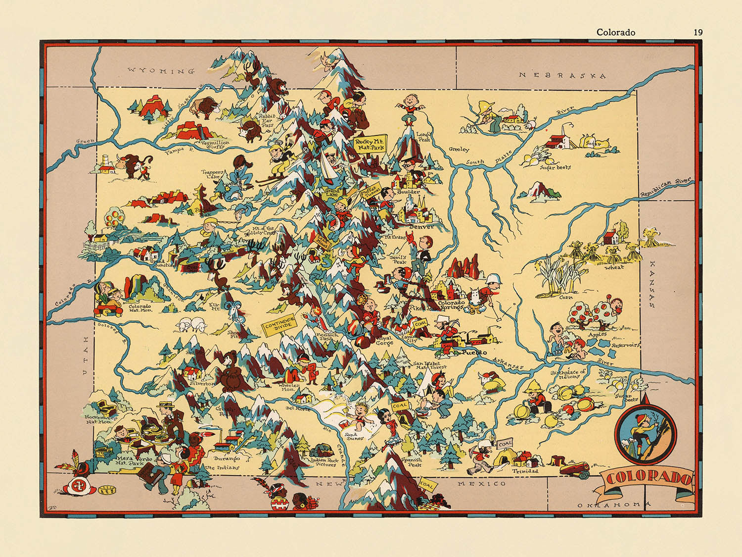


Pictorial Map of Colorado by Ruth Taylor White, 1935: Denver, Rocky Mountains, Pikes Peak, Mesa Verde, Great Sand Dunes

-
![]() Handmade in the UK (we're based in London)
Handmade in the UK (we're based in London)
-
FREE worldwide delivery in 2-3 days ⓘ
Free delivery in 2-3 days
Your map should be delivered in 2-3 working days with free delivery, worldwide.
We make maps by hand locally in 23 countries, including the UK
![]() . If you're buying a gift for someone in another country, we will make the map locally to them.
. If you're buying a gift for someone in another country, we will make the map locally to them.You will never pay import tax or customs duty.
Express delivery is available at checkout which can reduce the delivery time to 1-2 days.
Please note that personalised maps, and larger framed maps, can take longer to produce and deliver.
If you need your order to arrive by a certain date, contact me and we can discuss your options.
-
90 day money back guarantee ⓘ
90 days to return and refund
Products can be returned within 90 days for a full refund, or exchange for another product.
For personalised or custom made items, we may offer you a non-expiring gift card, as we cannot resell personalised orders.
If you have any questions, get in touch. For more information, see our full returns & exchanges policy.

My maps are rare, museum-grade, restored old maps sourced from libraries, auction houses and private collections across the globe.
Framing & free personalisation available
1. Select your size
2. Customise your map
Personalise your map with framing, hand-drawn customisation, vintage ageing, pop art text, unique 3D styling and moreGift message & custom finish

If you want to add a gift message, or a finish (jigsaw, aluminium board, etc.) that is not available here, please request it in the "order note" when you check out.
Every order is custom made, so if you need the size adjusted slightly, or printed on an unusual material, just let us know. We've done thousands of custom orders over the years, so there's (almost) nothing we can't manage.
You can also contact us before you order, if you prefer!

- Handmade locally. No import duty or tax
- FREE Delivery. Arrives in 2-3 days
- Love it or your money back
- Questions? WhatsApp me any time
Own a piece of history
5,000+ 5 star reviews


Step into the vibrant world of 1930s America with "Colorado," a masterful pictorial map crafted by the talented Ruth Taylor White in 1935. This captivating piece stands as a visual celebration of the Centennial State, inviting viewers to explore its rich tapestry of landscapes, cultures, and industries through a lens of playful artistry. The original title, simply "Colorado," hints at the map’s intent: to encapsulate the essence of the state in a single, enchanting tableau. Every inch is alive with color and character, making it not only a geographic reference but also a window into the cultural imagination of its era.
Ruth Taylor White, renowned for her whimsical approach to cartography, imbued this map with both humor and historical insight. Her distinctive style merges cartoonish illustrations with meticulous attention to local detail, resulting in a work that is as informative as it is delightful. White’s maps are celebrated for their ability to distill complex regional identities into accessible, engaging visuals, and "Colorado" is no exception. Here, her artistry transforms the state’s diverse terrain into a lively panorama, each county and region brought to life with vivid scenes and clever caricatures.
The map’s design is a testament to the era’s fascination with both exploration and entertainment. Dominating the western expanse, the majestic Rocky Mountains rise in bold relief, while Pikes Peak and the dramatic mesas of the southwest are rendered with affectionate exaggeration. National treasures such as Mesa Verde National Park are lovingly illustrated, and the iconic Great Sand Dunes are depicted with a flourish, highlighting the state’s extraordinary natural diversity. These elements are not merely decorative; they serve as cultural touchstones, reflecting the pride and wonder that Coloradans—and Americans at large—held for their unique landscapes.
Beyond its natural wonders, the map is a lively chronicle of Colorado’s economic and social life in the 1930s. Mining operations, cattle ranches, and oil derricks populate the terrain, while scenes of agriculture and forestry evoke the industrious spirit of the plains and foothills. White’s playful depictions of skiing, wildlife, and Native American heritage provide a nuanced, if stylized, glimpse into the state’s multifaceted identity. Each illustration is a conversation starter, inviting viewers to reflect on the stories and stereotypes that shaped Colorado’s image in the national consciousness.
The map’s cultural and historical significance extends to its detailed rendering of Colorado’s cities and towns, from the bustling capital of Denver to the storied mining town of Leadville. Modern metropolises like Aurora and Fort Collins share space with frontier settlements such as Trinidad and Gunnison, all set within the state’s distinctive county boundaries. In capturing both the myth and reality of Colorado, Ruth Taylor White’s "Colorado" stands as a cherished artifact—one that blends artistry, history, and cartographic innovation into a single, unforgettable vision.
Cities and towns on this map
- Denver
- Colorado Springs
- Aurora
- Fort Collins
- Lakewood
- Pueblo
- Boulder
- Greeley
- Grand Junction
- Durango
- Trinidad
- Leadville
- Salida
- Montrose
- Alamosa
- Lamar
- La Junta
- Sterling
- Walsenburg
- Gunnison
Notable Features & Landmarks
- Rocky Mountains illustrated prominently across the western part of the state
- Pikes Peak depicted and labeled
- Mesa Verde National Park illustrated and labeled
- Sand dunes depicted in the southern part of the state (Great Sand Dunes area)
- Mining activities illustrated, especially in mountainous regions
- Cattle ranching and cowboys depicted in the plains and foothills
- Skiing and winter sports illustrated in mountainous areas
- Native American imagery shown in the southwestern region
- Agricultural scenes, including wheat and corn, depicted in the eastern plains
- Oil derricks and oil industry illustrations
- Illustrations of forests and lumbering activities
- Depictions of wildlife, such as deer and bears
Historical and design context
- Name of the map: Colorado
- Original mapmaker: Ruth Taylor White
- Date of creation: 1935
- Map type: County or State Thematic and Pictorial map
- Artistic style: Whimsical, cartoonish, and visually rich, using humor and artistry to depict the state's identity and culture
- Themes: Vivid illustrations showcase stereotypical scenes and imagery from Colorado in the 1930s, reflecting both the landscape and cultural perceptions of the era
- Cultural commentary: The illustrations provide insight into the social and regional stereotypes prevalent in 1930s America, making the map a cultural artifact as well as a geographic one
- Historical significance: Offers a snapshot of how Colorado was viewed and represented in popular culture during the mid-20th century
- Design context: The map merges entertainment and information, typical of pictorial maps from this period, and is part of a broader trend in American mapmaking that prioritized visual storytelling
Please double check the images to make sure that a specific town or place is shown on this map. You can also get in touch and ask us to check the map for you.
This map looks great at every size, but I always recommend going for a larger size if you have space. That way you can easily make out all of the details.
This map looks amazing at sizes all the way up to 50in (125cm). If you are looking for a larger map, please get in touch.
The model in the listing images is holding the 18x24in (45x60cm) version of this map.
The fifth listing image shows an example of my map personalisation service.
If you’re looking for something slightly different, check out my collection of the best old maps to see if something else catches your eye.
Please contact me to check if a certain location, landmark or feature is shown on this map.
This would make a wonderful birthday, Christmas, Father's Day, work leaving, anniversary or housewarming gift for someone from the areas covered by this map.
This map is available as a giclée print on acid free archival matte paper, or you can buy it framed. The frame is a nice, simple black frame that suits most aesthetics. Please get in touch if you'd like a different frame colour or material. My frames are glazed with super-clear museum-grade acrylic (perspex/acrylite), which is significantly less reflective than glass, safer, and will always arrive in perfect condition.
This map is also available as a float framed canvas, sometimes known as a shadow gap framed canvas or canvas floater. The map is printed on artist's cotton canvas and then stretched over a handmade box frame. We then "float" the canvas inside a wooden frame, which is available in a range of colours (black, dark brown, oak, antique gold and white). This is a wonderful way to present a map without glazing in front. See some examples of float framed canvas maps and explore the differences between my different finishes.
For something truly unique, this map is also available in "Unique 3D", our trademarked process that dramatically transforms the map so that it has a wonderful sense of depth. We combine the original map with detailed topography and elevation data, so that mountains and the terrain really "pop". For more info and examples of 3D maps, check my Unique 3D page.
For most orders, delivery time is about 3 working days. Personalised and customised products take longer, as I have to do the personalisation and send it to you for approval, which usually takes 1 or 2 days.
Please note that very large framed orders usually take longer to make and deliver.
If you need your order to arrive by a certain date, please contact me before you order so that we can find the best way of making sure you get your order in time.
I print and frame maps and artwork in 23 countries around the world. This means your order will be made locally, which cuts down on delivery time and ensures that it won't be damaged during delivery. You'll never pay customs or import duty, and we'll put less CO2 into the air.
All of my maps and art prints are well packaged and sent in a rugged tube if unframed, or surrounded by foam if framed.
I try to send out all orders within 1 or 2 days of receiving your order, though some products (like face masks, mugs and tote bags) can take longer to make.
If you select Express Delivery at checkout your order we will prioritise your order and send it out by 1-day courier (Fedex, DHL, UPS, Parcelforce).
Next Day delivery is also available in some countries (US, UK, Singapore, UAE) but please try to order early in the day so that we can get it sent out on time.
My standard frame is a gallery style black ash hardwood frame. It is simple and quite modern looking. My standard frame is around 20mm (0.8in) wide.
I use super-clear acrylic (perspex/acrylite) for the frame glass. It's lighter and safer than glass - and it looks better, as the reflectivity is lower.
Six standard frame colours are available for free (black, dark brown, dark grey, oak, white and antique gold). Custom framing and mounting/matting is available if you're looking for something else.
Most maps, art and illustrations are also available as a framed canvas. We use matte (not shiny) cotton canvas, stretch it over a sustainably sourced box wood frame, and then 'float' the piece within a wood frame. The end result is quite beautiful, and there's no glazing to get in the way.
All frames are provided "ready to hang", with either a string or brackets on the back. Very large frames will have heavy duty hanging plates and/or a mounting baton. If you have any questions, please get in touch.
See some examples of my framed maps and framed canvas maps.
Alternatively, I can also supply old maps and artwork on canvas, foam board, cotton rag and other materials.
If you want to frame your map or artwork yourself, please read my size guide first.
My maps are extremely high quality reproductions of original maps.
I source original, rare maps from libraries, auction houses and private collections around the world, restore them at my London workshop, and then use specialist giclée inks and printers to create beautiful maps that look even better than the original.
My maps are printed on acid-free archival matte (not glossy) paper that feels very high quality and almost like card. In technical terms the paper weight/thickness is 10mil/200gsm. It's perfect for framing.
I print with Epson ultrachrome giclée UV fade resistant pigment inks - some of the best inks you can find.
I can also make maps on canvas, cotton rag and other exotic materials.
Learn more about The Unique Maps Co.
Map personalisation
If you're looking for the perfect anniversary or housewarming gift, I can personalise your map to make it truly unique. For example, I can add a short message, or highlight an important location, or add your family's coat of arms.
The options are almost infinite. Please see my map personalisation page for some wonderful examples of what's possible.
To order a personalised map, select "personalise your map" before adding it to your basket.
Get in touch if you're looking for more complex customisations and personalisations.
Map ageing
I have been asked hundreds of times over the years by customers if they could buy a map that looks even older.
Well, now you can, by selecting Aged before you add a map to your basket.
All the product photos you see on this page show the map in its Original form. This is what the map looks like today.
If you select Aged, I will age your map by hand, using a special and unique process developed through years of studying old maps, talking to researchers to understand the chemistry of aging paper, and of course... lots of practice!
If you're unsure, stick to the Original colour of the map. If you want something a bit darker and older looking, go for Aged.
If you are not happy with your order for any reason, contact me for a no-quibble refund. Please see our returns and refund policy for more information.
I am very confident you will like your restored map or art print. I have been doing this since 1984. I'm a 5-star Etsy seller. I have sold tens of thousands of maps and art prints and have over 5,000 real 5-star reviews.
I use a unique process to restore maps and artwork that is massively time consuming and labour intensive. Hunting down the original maps and illustrations can take months. I use state of the art and eye-wateringly expensive technology to scan and restore them. As a result, I guarantee my maps and art prints are a cut above the rest - that's why I can offer a no-quibble refund.
Almost all of my maps and art prints look amazing at large sizes (200cm, 6.5ft+) and I can frame and deliver them to you as well, via special oversized courier. Contact me to discuss your specific needs.
Or try searching for something!


