


Rare Old Tourist Map of Moscow by Getmanski, 1955: Kremlin, Red Square, Bolshoi Theatre, St. Basil's, Lenin's Mausoleum
20% off 2 — 33% off 3
Add any two eligible items to your bag to receive 20% off. Add a third and it will be complimentary (equivalent to 33% off when purchasing three).
No code needed — the offer applies automatically at checkout.
Valid on all standard maps and fine art prints. You can mix and match any designs.
If you’d like to ship items to multiple addresses, please contact us before placing your order.
Custom and bespoke commissions are excluded.
Contact us if you have any questions
 Designed in London Made in the UK
Designed in London • Made in the UK
Designed in London Made in the UK
Designed in London • Made in the UK

Choose your size
Framing


(More info)
Gift message & custom finish

If you want to add a gift message, or a finish (jigsaw, aluminium board, etc.) that is not available here, please request it in the "order note" when you check out.
Every order is custom made, so if you need the size adjusted slightly, or printed on an unusual material, just let us know. We've done thousands of custom orders over the years, so there's (almost) nothing we can't manage.
You can also contact us before you order, if you prefer!

- Made locally for fast, safe delivery
- Free worldwide delivery, with no import duty surprises
- 90-day returns and 5-year guarantee
- Need advice? Message us on WhatsApp
Own a piece of history
7,000+ 5 star reviews


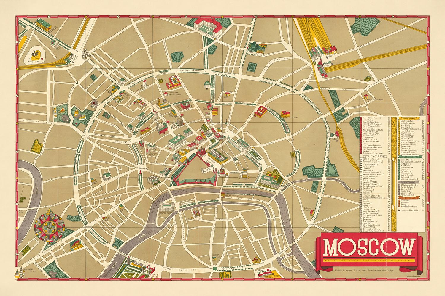
The "Pictographic Map of Moscow," created by Mikhail Getmanski and published by Editions Vnechtorgisdat in the mid-1950s, is a captivating window into the heart of the Soviet Union during the Cold War. This meticulously detailed map showcases the Soviet capital's main sites, with the Kremlin at its center. Interestingly, while the Kremlin's walls are outlined, the buildings within are omitted, reflecting the era's heightened security and secrecy. This map, printed in English, was designed for the curious Western tourists and foreign diplomats who ventured into Moscow, offering them a rare glimpse into this enigmatic city.
Moscow, as depicted in this map, is a city of grand avenues and historic squares. The map highlights significant neighborhoods and landmarks, such as Red Square, Lenin's Mausoleum, and the iconic St. Basil's Cathedral, each rendered in charming pictographic detail. The Bolshoi Theatre, another notable landmark, stands as a testament to Moscow's rich cultural heritage. The map's inclusion of these sites underscores the city's importance as a political, cultural, and historical epicenter.
The map also provides a fascinating overview of Moscow's extensive transportation network, with key train stations and major thoroughfares like Gorky Street and Tverskaya Street clearly marked. These roads and squares not only facilitate movement within the city but also connect the various neighborhoods, each with its unique character and history. The depiction of Komsomolskaya Square and Lubyanka Square, for instance, offers insight into the city's urban layout and its role in the daily lives of Muscovites.
Green spaces and parks are also prominently featured, adding a layer of depth to the city's landscape. These areas provide a stark contrast to the bustling urban environment, offering residents and visitors alike a place for relaxation and recreation. The presence of the Moscow River, winding through the city, further enhances the map's visual appeal and historical significance, highlighting the river's role in shaping Moscow's development over the centuries.
Mikhail Getmanski's design and the careful execution by Editions Vnechtorgisdat make this map not only a practical guide but also a work of art. The map's pictographic style, combined with its detailed key identifying numerous theaters, museums, monuments, and hotels, provides a comprehensive snapshot of Moscow during a pivotal period in history. This map is more than just a navigational tool; it is a testament to the city's enduring allure and the complexities of its past, making it a prized addition to any collection of historical maps.
Streets and roads on this map
- Arbat Square
- Bolshaya Dmitrovka
- Bolshaya Lubyanka
- Bolshaya Polyanka
- Bolshaya Sadovaya
- Bolshaya Yakimanka
- Gorky Street
- Ilinka
- Kalinin Prospekt
- Kamergersky Pereulok
- Kirov Street
- Komsomolskaya Square
- Kuznetsky Most
- Kutuzovsky Prospekt
- Leningradsky Prospekt
- Lubyanka Square
- Malaya Dmitrovka
- Malaya Lubyanka
- Malaya Polyanka
- Malaya Sadovaya
- Manezhnaya Square
- Mokhovaya
- Novy Arbat
- Okhotny Ryad
- Petrovka
- Pushechnaya
- Sverdlov Square
- Tverskaya Street
- Tverskaya-Yamskaya
- Vorovsky Street
Notable Features & Landmarks
- Red Square
- Lenin's Mausoleum
- Hotel Metropole
- Bolshoi Theatre
- St. Basil's Cathedral
- Kremlin (walls outlined)
- Moscow River
- Decorative compass rose in the lower left corner
- Key in the lower right identifying various sites, theaters, museums, monuments, train stations, hotels, and the "Intotourist" travel center
- Several green areas and parks
Historical and design context
- An attractive and engaging 1950s pictographic map of Moscow, showing the Soviet capital's main sites during the height of the Cold War.
- Provides a rare English-language pictographic map of Moscow, then the capital of the Soviet Union, and one of the intriguing enigmas to Westerners.
- The map features the center of the city, with the Kremlin at the middle. Curiously, while the walls of the Kremlin are outlined, no details with respect to the buildings inside are included.
- The Kremlin was the epicenter of the Soviet government, and no foreigners were allowed to visit the complex, so details were removed to avoid encouraging any 'undue curiosity'.
- Key illustrated sites include Red Square, Lenin's Mausoleum, the Hotel Metropole, the Bolshoi Theatre, St. Basil's Cathedral, amongst many others.
- A key in the lower right identifies 19 general sites, 38 theaters, 18 museums, 11 monuments, 8 train stations, 4 hotels, and the "Intotourist" travel center.
- Printed during the height of the Cold War, when tensions between the West and the USSR were high.
- Following the death of Soviet dictator Joseph Stalin in 1953, the political climate within the Soviet Union eased somewhat under Nikita Krushchev.
- Westerners were able to visit Moscow as tourists, although their movements were carefully guided and supervised by Soviet agents.
- The map was printed for curious Western tourists and members of the foreign diplomatic corps in Moscow.
Please double check the images to make sure that a specific town or place is shown on this map. You can also get in touch and ask us to check the map for you.
This map looks great at every size, but I always recommend going for a larger size if you have space. That way you can easily make out all of the details.
This map looks amazing at sizes all the way up to 100in (250cm). If you are looking for a larger map, please get in touch.
Please note: the labels on this map are hard to read if you order a map that is 16in (40cm) or smaller. The map is still very attractive, but if you would like to read the map easily, please buy a larger size.
The model in the listing images is holding the 24x36in (60x90cm) version of this map.
The fifth listing image shows an example of my map personalisation service.
If you’re looking for something slightly different, check out my collection of the best old maps to see if something else catches your eye.
Please contact me to check if a certain location, landmark or feature is shown on this map.
This would make a wonderful birthday, Christmas, Father's Day, work leaving, anniversary or housewarming gift for someone from the areas covered by this map.
This map is available as a giclée print on acid free archival matte paper, or you can buy it framed. The frame is a nice, simple black frame that suits most aesthetics. Please get in touch if you'd like a different frame colour or material. My frames are glazed with super-clear museum-grade acrylic (perspex/acrylite), which is significantly less reflective than glass, safer, and will always arrive in perfect condition.
This map is also available as a float framed canvas, sometimes known as a shadow gap framed canvas or canvas floater. The map is printed on artist's cotton canvas and then stretched over a handmade box frame. We then "float" the canvas inside a wooden frame, which is available in a range of colours (black, dark brown, oak, antique gold and white). This is a wonderful way to present a map without glazing in front. See some examples of float framed canvas maps and explore the differences between my different finishes.
For something truly unique, this map is also available in "Unique 3D", our trademarked process that dramatically transforms the map so that it has a wonderful sense of depth. We combine the original map with detailed topography and elevation data, so that mountains and the terrain really "pop". For more info and examples of 3D maps, check my Unique 3D page.
Many of our maps and art prints are chosen as thoughtful gifts for homes, offices, studies and meaningful places.
Choose a framed option for the easiest ready-to-hang gift, or choose an unframed print if the recipient may prefer to select their own frame.
We make orders locally in 23 countries around the world, so gifts can often be produced close to the recipient. This helps them arrive faster, travel more safely, and avoid customs or import duty surprises.
- We can deliver directly to the recipient
- Framed pieces arrive ready to hang
- Unframed prints are carefully packed in a strong protective tube
- Almost every order is made locally, for faster, safer gifting
- 90-day returns give the recipient time to decide
If you are not sure what to choose, please contact us. We can help you pick the right map, size, finish or delivery option.
Most orders are made locally and delivered in around 2–3 working days, depending on the product, size and destination.
We print and frame maps and artwork in 23 countries around the world, so your order is usually made close to you or your recipient. That means faster delivery, less time in transit, and no customs or import duty surprises.
Personalised and customised pieces usually take an extra 1–2 working days, because we prepare your design and send it to you for approval before printing.
Very large framed orders can take a little longer, as they need extra care in production and delivery.
Every order is carefully packaged: unframed prints are sent in a strong protective tube, while framed pieces are securely packed with protective materials around the frame.
If you need your order by a particular date, please contact us before ordering. We’ll check the best production route and delivery option for your location.
Express delivery is available at checkout for most countries. Next-day delivery is available in the UK, US, Singapore and the UAE.
Your order is covered by our 90-day returns policy and 5-year guarantee.
My standard frame is a gallery style black ash hardwood frame. It is simple and quite modern looking. My standard frame is around 20mm (0.8in) wide.
I use super-clear acrylic (perspex/acrylite) for the frame glass. It's lighter and safer than glass - and it looks better, as the reflectivity is lower.
Six standard frame colours are available for free (black, dark brown, dark grey, oak, white and antique gold). Custom framing and mounting/matting is available if you're looking for something else.
Most maps, art and illustrations are also available as a framed canvas. We use matte (not shiny) cotton canvas, stretch it over a sustainably sourced box wood frame, and then 'float' the piece within a wood frame. The end result is quite beautiful, and there's no glazing to get in the way.
All frames are provided "ready to hang", with either a string or brackets on the back. Very large frames will have heavy duty hanging plates and/or a mounting baton. If you have any questions, please get in touch.
See some examples of my framed maps and framed canvas maps.
Alternatively, I can also supply old maps and artwork on canvas, foam board, cotton rag and other materials.
If you want to frame your map or artwork yourself, please read my size guide first.
My maps are extremely high quality reproductions of original maps.
I source original, rare maps from libraries, auction houses and private collections around the world, restore them at my London workshop, and then use specialist giclée inks and printers to create beautiful maps that look even better than the original.
My maps are printed on acid-free archival matte (not glossy) paper that feels very high quality and almost like card. In technical terms the paper weight/thickness is 10mil/200gsm. It's perfect for framing.
I print with Epson ultrachrome giclée UV fade resistant pigment inks - some of the best inks you can find.
I can also make maps on canvas, cotton rag and other exotic materials.
Learn more about The Unique Maps Co.
Map personalisation
If you're looking for the perfect anniversary or housewarming gift, I can personalise your map to make it truly unique. For example, I can add a short message, or highlight an important location, or add your family's coat of arms.
The options are almost infinite. Please see my map personalisation page for some wonderful examples of what's possible.
To order a personalised map, select "personalise your map" before adding it to your basket.
Get in touch if you're looking for more complex customisations and personalisations.
Map ageing
I have been asked hundreds of times over the years by customers if they could buy a map that looks even older.
Well, now you can, by selecting Aged before you add a map to your basket.
All the product photos you see on this page show the map in its Original form. This is what the map looks like today.
If you select Aged, I will age your map by hand, using a special and unique process developed through years of studying old maps, talking to researchers to understand the chemistry of aging paper, and of course... lots of practice!
If you're unsure, stick to the Original colour of the map. If you want something a bit darker and older looking, go for Aged.
If you are not happy with your order for any reason, contact me and I'll get it fixed ASAP, free of charge. Please see my returns and refund policy for more information.
I am very confident you will like your restored map or art print. I have been doing this since 1984. I'm a 5-star Etsy seller. I have sold tens of thousands of maps and art prints and have over 5,000 real 5-star reviews. My work has been featured in interior design magazines, on the BBC, and on the walls of dozens of 5-star hotels.
I use a unique process to restore maps and artwork that is massively time consuming and labour intensive. Hunting down the original maps and illustrations can take months. I use state of the art and eye-wateringly expensive technology to scan and restore them. As a result, I guarantee my maps and art prints are a cut above the rest. I stand by my products and will always make sure you're 100% happy with what you receive.
Almost all of my maps and art prints look amazing at large sizes (200cm, 6.5ft+) and I can frame and deliver them to you as well, via special oversized courier. Contact me to discuss your specific needs.
Or try searching for something!


