


Rare Old Portolan Map of Europe by De Wit, 1675: Naval Chart, Mediterranean, North Sea, Atlantic
20% off 2 — 33% off 3
Add any two eligible items to your bag to receive 20% off. Add a third and it will be complimentary (equivalent to 33% off when purchasing three).
No code needed — the offer applies automatically at checkout.
Valid on all standard maps and fine art prints. You can mix and match any designs.
If you’d like to ship items to multiple addresses, please contact us before placing your order.
Custom and bespoke commissions are excluded.
Contact us if you have any questions
 Designed in London Made in the UK
Designed in London • Made in the UK
Designed in London Made in the UK
Designed in London • Made in the UK

Choose your size
Choose your finish


(More info)
Gift message & custom finish

If you want to add a gift message, or a finish (jigsaw, aluminium board, etc.) that is not available here, please request it in the "order note" when you check out.
Every order is custom made, so if you need the size adjusted slightly, or printed on an unusual material, just let us know. We've done thousands of custom orders over the years, so there's (almost) nothing we can't manage.
You can also contact us before you order, if you prefer!

- Made locally for fast, safe delivery
- No import duty or hidden fees
- Need advice? Message us on WhatsApp
Own a piece of history
7,000+ 5 star reviews


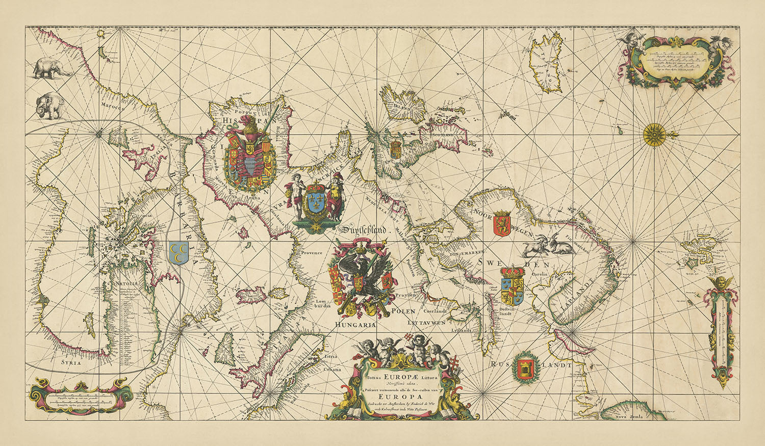
Embark on a captivating journey through time with the illustrious "Totius Europae Littora Novissime adita. Pascaert vertoonende alle de See-custen van Europa," a maritime chart crafted by the renowned Dutch cartographer Frederick De Wit in the year 1675. This chart, a masterpiece of the Golden Age of Dutch cartography, not only serves as a navigational tool but also as a piece of art, capturing the intricate coastlines of Europe with unparalleled precision and beauty. De Wit, celebrated for his detailed sea charts, meticulously illustrates the maritime landscape of Europe, from the rugged coasts of Norway to the sun-drenched shores of Dalmatia. His work stands as a testament to the era's profound advancements in navigational knowledge and cartographic skill, inviting us to explore the rich tapestry of Europe's coastal realms.
In an era dominated by the quest for knowledge and exploration, De Wit's chart illuminates the maritime routes that were the lifelines of commerce, conflict, and discovery. The chart is meticulously designed in the portolan style, emphasizing the coastal contours and maritime features over the inland territories, thereby providing invaluable information to the seafarers of the 17th century. This emphasis on coastal detail, coupled with the chart's unusual westward orientation, offers a unique perspective on Europe's maritime landscape, revealing the strategic importance of its ports and harbors. The inclusion of major sea routes, depicted with dotted lines, underscores the chart's practical utility in guiding the voyages that shaped the course of European history.
The chart is adorned with a rich tapestry of heraldic emblems, including the grand coats of arms of Spain, France, the Holy Roman Empire, and smaller ones for Norway, Sweden, "Ruslandt" (Russia), and England. These symbols of sovereignty and power provide a vivid glimpse into the geopolitical landscape of the time, highlighting the maritime dominions and rivalries that influenced the course of European history. The dedication to Charles II, King of Great Britain, France, and Ireland, further enriches the chart's historical context, linking it to the royal patronage and political ambitions of the era.
Beyond its navigational and geopolitical significance, De Wit's chart is a marvel of artistic expression. The decorative border, intricate illustrations of sea monsters, ships, and a compass rose, not only enhance its aesthetic appeal but also reflect the era's fascination with the unknown and the allure of the sea.
Frederick De Wit's "Totius Europae Littora Novissime adita" stands as a monumental achievement in the history of cartography, bridging the realms of art, science, and history. It offers a window into the 17th-century European world, capturing the spirit of an age marked by exploration, discovery, and the relentless pursuit of knowledge. This chart is not merely a map but a historical document, a work of art, and a testament to the enduring human desire to understand and navigate the vast and mysterious world that surrounds us.
Countries and regions on this map
- Africa
- Bohemia
- Brandenburg
- Circassia
- Croatia
- Dalmatia
- Denmark
- England
- Finland
- France
- Germany
- Greece
- Hungary
- Iceland
- Ireland
- Italy
- Livonia
- Lithuania
- Morocco
- Netherlands
- Norway
- Poland
- Portugal
- Prussia
- Romania
- Russia
- Scotland
- Serbia
- Sicily
- Spain
- Spitsbergen
- Sweden
- Switzerland
- Turkey
- Ukraine
- Wales
Notable Features & Landmarks
- Atlantic Ocean
- Arctic Ocean
- Baltic Sea
- Black Sea
- Caspian Sea
- Mediterranean Sea
- North Sea
- Norwegian Sea
- White Sea
- Alps
- Carpathian Mountains
- Caucasus Mountains
- Pyrenees
- Scandinavian Mountains
- Urals
- Major sea routes are shown with dotted lines.
- Major roads are shown with solid lines.
- The map is oriented with north at the top.
Historical and design context
- Title: Totius Europae Littora Novissime adita. Pascaert vertoonende alle de See-custen van Europa
- Date: 1675
- Mapmaker/Publisher: Frederick De Wit
- Frederick De Wit was a Dutch cartographer and publisher who was active in the 17th century. He is best known for his sea charts, which were highly regarded for their accuracy and detail.
- The map shows the coastlines of Europe, as well as the Mediterranean Sea and the North Sea.
- It includes the coats of arms of the key kingdoms of the time - Spain, France, and the Holy Roman Empire - as well as smaller coats of arms for Norway, Sweden, "Ruslandt" (Russia), and England.
- The map covers the area from Morocco to the Scandinavian island of Spitsbergen and Iceland, and west to east from Iceland to Dalmatia.
- The map is in the portolan style, which emphasizes coastal details over the inland regions. It is also oriented with the top to the west, which is unusual.
- The map is a valuable historical document that provides insight into the state of European cartography in the 17th century. It is also a beautiful example of the art of cartography.
Please double check the images to make sure that a specific town or place is shown on this map. You can also get in touch and ask us to check the map for you.
This map looks great at every size, but I always recommend going for a larger size if you have space. That way you can easily make out all of the details.
This map looks amazing at sizes all the way up to 100in (250cm). If you are looking for a larger map, please get in touch.
Please note: the labels on this map are hard to read if you order a map that is 20in (50cm) or smaller. The map is still very attractive, but if you would like to read the map easily, please buy a larger size.
This map is wider than most maps, which would make it a perfect statement piece above a mantelpiece, sofa or desk.
The fifth listing image shows an example of my map personalisation service.
If you’re looking for something slightly different, check out my collection of the best old maps to see if something else catches your eye.
Please contact me to check if a certain location, landmark or feature is shown on this map.
This would make a wonderful birthday, Christmas, Father's Day, work leaving, anniversary or housewarming gift for someone from the areas covered by this map.
This map is available as a giclée print on acid free archival matte paper, or you can buy it framed. The frame is a nice, simple black frame that suits most aesthetics. Please get in touch if you'd like a different frame colour or material. My frames are glazed with super-clear museum-grade acrylic (perspex/acrylite), which is significantly less reflective than glass, safer, and will always arrive in perfect condition.
This map is also available as a float framed canvas, sometimes known as a shadow gap framed canvas or canvas floater. The map is printed on artist's cotton canvas and then stretched over a handmade box frame. We then "float" the canvas inside a wooden frame, which is available in a range of colours (black, dark brown, oak, antique gold and white). This is a wonderful way to present a map without glazing in front. See some examples of float framed canvas maps and explore the differences between my different finishes.
For something truly unique, this map is also available in "Unique 3D", our trademarked process that dramatically transforms the map so that it has a wonderful sense of depth. We combine the original map with detailed topography and elevation data, so that mountains and the terrain really "pop". For more info and examples of 3D maps, check my Unique 3D page.
Many of our maps and art prints are chosen as thoughtful gifts for homes, offices, studies and meaningful places.
Choose a framed option for the easiest ready-to-hang gift, or choose an unframed print if the recipient may prefer to select their own frame.
We make orders locally in 23 countries around the world, so gifts can often be produced close to the recipient. This helps them arrive faster, travel more safely, and avoid customs or import duty surprises.
- We can deliver directly to the recipient
- Framed pieces arrive ready to hang
- Unframed prints are carefully packed in a strong protective tube
- Almost every order is made locally, for faster, safer gifting
- 90-day returns give the recipient time to decide
If you are not sure what to choose, please contact us. We can help you pick the right map, size, finish or delivery option.
Most orders are made locally and delivered in around 2–3 working days, depending on the product, size and destination.
We print and frame maps and artwork in 23 countries around the world, so your order is usually made close to you or your recipient. That means faster delivery, less time in transit, and no customs or import duty surprises.
Personalised and customised pieces usually take an extra 1–2 working days, because we prepare your design and send it to you for approval before printing.
Very large framed orders can take a little longer, as they need extra care in production and delivery.
Every order is carefully packaged: unframed prints are sent in a strong protective tube, while framed pieces are securely packed with protective materials around the frame.
If you need your order by a particular date, please contact us before ordering. We’ll check the best production route and delivery option for your location.
Express delivery is available at checkout for most countries. Next-day delivery is available in the UK, US, Singapore and the UAE.
Your order is covered by our 90-day returns policy and 10-year guarantee.
Our standard frame is a gallery-style black ash hardwood frame, with a simple, modern look. It is approximately 20mm (0.8in) wide. You can also view some lovely customer photos of framed maps and art.
We use super-clear acrylic glazing, also known as Perspex or Acrylite, instead of traditional glass. It is lighter, safer, and has lower reflectivity, giving the artwork a clearer, cleaner appearance.
Six standard frame colours are available at no extra cost: black, dark brown, dark grey, oak, white, and antique gold. Custom framing and mounting/matting is also available for customers looking for something more specific.
Most maps, art prints, and illustrations are also available as a framed canvas. We use matte cotton canvas, stretch it over a sustainably sourced wooden box frame, and then float the piece within a wooden outer frame. The finished result is beautifully presented, with no glazing between you and the artwork.
All frames are supplied ready to hang, with either string or brackets fitted to the back. Very large frames will include heavy-duty hanging plates and/or a mounting baton. If you have any questions, please get in touch.
We can also supply old maps and artwork on canvas, foam board, cotton rag, and other materials.
If you would prefer to frame your map or artwork yourself, please read our size guide before ordering.
My maps are extremely high quality reproductions of original maps.
I source original, rare maps from libraries, auction houses and private collections around the world, restore them at my London workshop, and then use specialist giclée inks and printers to create beautiful maps that look even better than the original.
My maps are printed on acid-free archival matte (not glossy) paper that feels very high quality and almost like card. In technical terms the paper weight/thickness is 10mil/200gsm. It's perfect for framing.
I print with Epson ultrachrome giclée UV fade resistant pigment inks - some of the best inks you can find.
I can also make maps on canvas, cotton rag and other exotic materials.
Learn more about The Unique Maps Co.
Map personalisation
If you're looking for the perfect anniversary or housewarming gift, I can personalise your map to make it truly unique. For example, I can add a short message, or highlight an important location, or add your family's coat of arms.
The options are almost infinite. Please see my map personalisation page for some wonderful examples of what's possible.
To order a personalised map, select "personalise your map" before adding it to your basket.
Get in touch if you're looking for more complex customisations and personalisations.
Map ageing
I have been asked hundreds of times over the years by customers if they could buy a map that looks even older.
Well, now you can, by selecting Aged before you add a map to your basket.
All the product photos you see on this page show the map in its Original form. This is what the map looks like today.
If you select Aged, I will age your map by hand, using a special and unique process developed through years of studying old maps, talking to researchers to understand the chemistry of aging paper, and of course... lots of practice!
If you're unsure, stick to the Original colour of the map. If you want something a bit darker and older looking, go for Aged.
If you are not happy with your order for any reason, contact me and I'll get it fixed ASAP, free of charge. Please see my returns and refund policy for more information.
I am very confident you will like your restored map or art print. I have been doing this since 1984. I'm a 5-star Etsy seller. I have sold tens of thousands of maps and art prints and have over 5,000 real 5-star reviews. My work has been featured in interior design magazines, on the BBC, and on the walls of dozens of 5-star hotels.
I use a unique process to restore maps and artwork that is massively time consuming and labour intensive. Hunting down the original maps and illustrations can take months. I use state of the art and eye-wateringly expensive technology to scan and restore them. As a result, I guarantee my maps and art prints are a cut above the rest. I stand by my products and will always make sure you're 100% happy with what you receive.
Almost all of my maps and art prints look amazing at large sizes (200cm, 6.5ft+) and I can frame and deliver them to you as well, via special oversized courier. Contact me to discuss your specific needs.
Or try searching for something!


