


Rare Old Pictorial Map of the United States by Clegg, 1926
20% off 2 — 33% off 3
Add any two eligible items to your bag to receive 20% off. Add a third and it will be complimentary (equivalent to 33% off when purchasing three).
No code needed — the offer applies automatically at checkout.
Valid on all standard maps and fine art prints. You can mix and match any designs.
If you’d like to ship items to multiple addresses, please contact us before placing your order.
Custom and bespoke commissions are excluded.
Contact us if you have any questions
 Designed in London Made in the UK
Designed in London • Made in the UK
Designed in London Made in the UK
Designed in London • Made in the UK

Choose your size
Choose your finish


(More info)
Gift message & custom finish

If you want to add a gift message, or a finish (jigsaw, aluminium board, etc.) that is not available here, please request it in the "order note" when you check out.
Every order is custom made, so if you need the size adjusted slightly, or printed on an unusual material, just let us know. We've done thousands of custom orders over the years, so there's (almost) nothing we can't manage.
You can also contact us before you order, if you prefer!

- Made locally for fast, safe delivery
- No import duty or hidden fees
- Need advice? Message us on WhatsApp
Own a piece of history
7,000+ 5 star reviews


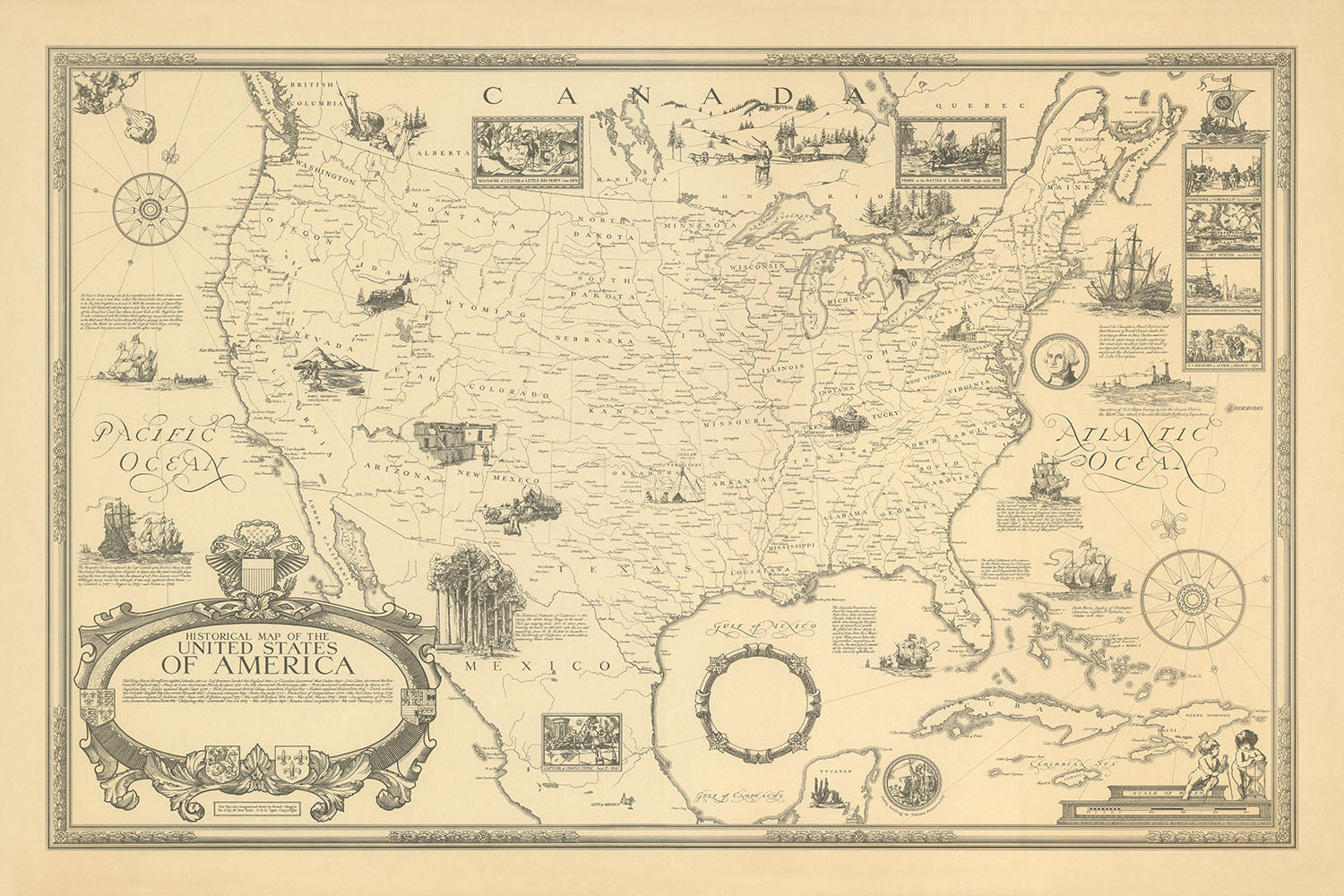
The "Historical Map of the United States of America," crafted by the illustrious Ernest Clegg in 1926, is a remarkable testament to the rich tapestry of American history and geography. This map, a product of Clegg's profound expertise as an illustrator and cartographer, beautifully encapsulates the nation's past through detailed illustrations and thematic elements. Clegg, a British-born artist who spent significant periods in the United States, imbued this map with a unique blend of American and British cartographic traditions, making it a captivating piece for both history enthusiasts and collectors alike.
Ernest Clegg's meticulous craftsmanship is evident in every corner of this map. His illustrations bring to life significant historical events and landmarks, from the bustling streets of New York to the serene landscapes of the Pacific Northwest. The map not only charts the physical terrain of the United States but also narrates its storied past through vignettes and decorative elements. Clegg's ability to merge cartographic precision with artistic flair results in a map that is as informative as it is visually stunning.
The map's depiction of cities and towns offers a fascinating glimpse into the urban landscape of early 20th-century America. Major cities like New York, Chicago, and Los Angeles are prominently featured, reflecting their burgeoning importance during this period. Smaller towns and settlements are also meticulously marked, providing a comprehensive overview of the nation's urban development. This detailed representation of human settlements underscores the dynamic growth and expansion that characterized the United States in the early 1900s.
Beyond its urban centers, the map highlights the natural beauty and geographical diversity of the United States. From the majestic Rocky Mountains to the vast expanses of the Great Plains, Clegg's illustrations capture the varied landscapes that define the American continent. Bodies of water such as the Pacific and Atlantic Oceans, as well as the Gulf of Mexico, are elegantly rendered, emphasizing their significance in the nation's history and development. The inclusion of these natural features adds depth and context to the map, making it a comprehensive portrayal of the United States.
The historical significance of this map is further enhanced by its thematic elements and decorative illustrations. Clegg's artistic renditions of historical events, maritime activities, and notable landmarks provide a rich narrative that complements the geographical information. The ornate compass roses, cartouches, and border designs add a touch of elegance and sophistication, reflecting the map's dual purpose as an educational tool and a decorative piece. This map is not merely a representation of the United States; it is a celebration of its history, culture, and enduring legacy.
Cities and towns on this map
- United States:
- New York
- Chicago
- Los Angeles
- Philadelphia
- Detroit
- San Francisco
- Boston
- St. Louis
- Washington, D.C.
- Baltimore
- Cleveland
- Pittsburgh
- New Orleans
- Cincinnati
- Minneapolis
- Kansas City
- Seattle
- Denver
- Atlanta
- Milwaukee
- Portland
- San Antonio
- San Diego
- Dallas
- Houston
- Buffalo
- Phoenix
- Salt Lake City
- Indianapolis
- Columbus
- Omaha
- Memphis
- Louisville
- Richmond
-
Nashville
-
Canada:
- Toronto
- Montreal
-
Vancouver
-
Mexico:
- Mexico City
- Guadalajara
- Monterrey
Notable Features & Landmarks
- Inset maps:
- Several inset maps depicting historical events and regions.
- Illustrations:
- Various historical vignettes and illustrations throughout the map.
- Illustrations of significant events and figures in U.S. history.
- Landmarks:
- Illustrations of historical landmarks and buildings.
- Bodies of water:
- Pacific Ocean
- Atlantic Ocean
- Gulf of Mexico
- Borders:
- U.S. borders with Canada and Mexico.
- Mountains:
- Various mountain ranges depicted through illustrations.
- Other notable features:
- Decorative compass roses.
- Ornate cartouches and border designs.
- Illustrations of ships and maritime activities.
Historical and design context
- Name of the map: Historical Map of the United States of America
- Date of creation: 1926
- Mapmaker/Publisher: Ernest Clegg
- Interesting context about the mapmaker: Ernest Clegg was known for his detailed and artistic cartographic works. His dual national experiences in Britain and the United States influenced his cartographic style and content.
- Topics and themes shown on the map:
- The map depicts historical events and landmarks of the United States.
- Illustrations and thematic elements reflect significant historical moments and cultural aspects.
- Countries and regions shown on the map:
- United States of America
- Parts of Canada
- Parts of Mexico
- Caribbean region
- Design or style of the map:
- The map is a pictorial and thematic representation.
- It includes detailed illustrations, historical vignettes, and decorative elements.
- Historical significance or context:
- The map reflects the historical understanding and artistic interpretation of the United States in the early 20th century.
- It serves as both an educational tool and a decorative piece, illustrating the rich history and geography of the United States.
Please double check the images to make sure that a specific town or place is shown on this map. You can also get in touch and ask us to check the map for you.
This map looks great at every size, but I always recommend going for a larger size if you have space. That way you can easily make out all of the details.
This map looks amazing at sizes all the way up to 100in (250cm). If you are looking for a larger map, please get in touch.
Please note: the labels on this map are hard to read if you order a map that is 20in (50cm) or smaller. The map is still very attractive, but if you would like to read the map easily, please buy a larger size.
The model in the listing images is holding the 24x36in (60x90cm) version of this map.
The fifth listing image shows an example of my map personalisation service.
If you’re looking for something slightly different, check out my collection of the best old maps to see if something else catches your eye.
Please contact me to check if a certain location, landmark or feature is shown on this map.
This would make a wonderful birthday, Christmas, Father's Day, work leaving, anniversary or housewarming gift for someone from the areas covered by this map.
This map is available as a giclée print on acid free archival matte paper, or you can buy it framed. The frame is a nice, simple black frame that suits most aesthetics. Please get in touch if you'd like a different frame colour or material. My frames are glazed with super-clear museum-grade acrylic (perspex/acrylite), which is significantly less reflective than glass, safer, and will always arrive in perfect condition.
This map is also available as a float framed canvas, sometimes known as a shadow gap framed canvas or canvas floater. The map is printed on artist's cotton canvas and then stretched over a handmade box frame. We then "float" the canvas inside a wooden frame, which is available in a range of colours (black, dark brown, oak, antique gold and white). This is a wonderful way to present a map without glazing in front. See some examples of float framed canvas maps and explore the differences between my different finishes.
For something truly unique, this map is also available in "Unique 3D", our trademarked process that dramatically transforms the map so that it has a wonderful sense of depth. We combine the original map with detailed topography and elevation data, so that mountains and the terrain really "pop". For more info and examples of 3D maps, check my Unique 3D page.
Many of our maps and art prints are chosen as thoughtful gifts for homes, offices, studies and meaningful places.
Choose a framed option for the easiest ready-to-hang gift, or choose an unframed print if the recipient may prefer to select their own frame.
We make orders locally in 23 countries around the world, so gifts can often be produced close to the recipient. This helps them arrive faster, travel more safely, and avoid customs or import duty surprises.
- We can deliver directly to the recipient
- Framed pieces arrive ready to hang
- Unframed prints are carefully packed in a strong protective tube
- Almost every order is made locally, for faster, safer gifting
- 90-day returns give the recipient time to decide
If you are not sure what to choose, please contact us. We can help you pick the right map, size, finish or delivery option.
Most orders are made locally and delivered in around 2–3 working days, depending on the product, size and destination.
We print and frame maps and artwork in 23 countries around the world, so your order is usually made close to you or your recipient. That means faster delivery, less time in transit, and no customs or import duty surprises.
Personalised and customised pieces usually take an extra 1–2 working days, because we prepare your design and send it to you for approval before printing.
Very large framed orders can take a little longer, as they need extra care in production and delivery.
Every order is carefully packaged: unframed prints are sent in a strong protective tube, while framed pieces are securely packed with protective materials around the frame.
If you need your order by a particular date, please contact us before ordering. We’ll check the best production route and delivery option for your location.
Express delivery is available at checkout for most countries. Next-day delivery is available in the UK, US, Singapore and the UAE.
Your order is covered by our 90-day returns policy and 10-year guarantee.
Our standard frame is a gallery-style black ash hardwood frame, with a simple, modern look. It is approximately 20mm (0.8in) wide. You can also view some lovely customer photos of framed maps and art.
We use super-clear acrylic glazing, also known as Perspex or Acrylite, instead of traditional glass. It is lighter, safer, and has lower reflectivity, giving the artwork a clearer, cleaner appearance.
Six standard frame colours are available at no extra cost: black, dark brown, dark grey, oak, white, and antique gold. Custom framing and mounting/matting is also available for customers looking for something more specific.
Most maps, art prints, and illustrations are also available as a framed canvas. We use matte cotton canvas, stretch it over a sustainably sourced wooden box frame, and then float the piece within a wooden outer frame. The finished result is beautifully presented, with no glazing between you and the artwork.
All frames are supplied ready to hang, with either string or brackets fitted to the back. Very large frames will include heavy-duty hanging plates and/or a mounting baton. If you have any questions, please get in touch.
We can also supply old maps and artwork on canvas, foam board, cotton rag, and other materials.
If you would prefer to frame your map or artwork yourself, please read our size guide before ordering.
My maps are extremely high quality reproductions of original maps.
I source original, rare maps from libraries, auction houses and private collections around the world, restore them at my London workshop, and then use specialist giclée inks and printers to create beautiful maps that look even better than the original.
My maps are printed on acid-free archival matte (not glossy) paper that feels very high quality and almost like card. In technical terms the paper weight/thickness is 10mil/200gsm. It's perfect for framing.
I print with Epson ultrachrome giclée UV fade resistant pigment inks - some of the best inks you can find.
I can also make maps on canvas, cotton rag and other exotic materials.
Learn more about The Unique Maps Co.
Map personalisation
If you're looking for the perfect anniversary or housewarming gift, I can personalise your map to make it truly unique. For example, I can add a short message, or highlight an important location, or add your family's coat of arms.
The options are almost infinite. Please see my map personalisation page for some wonderful examples of what's possible.
To order a personalised map, select "personalise your map" before adding it to your basket.
Get in touch if you're looking for more complex customisations and personalisations.
Map ageing
I have been asked hundreds of times over the years by customers if they could buy a map that looks even older.
Well, now you can, by selecting Aged before you add a map to your basket.
All the product photos you see on this page show the map in its Original form. This is what the map looks like today.
If you select Aged, I will age your map by hand, using a special and unique process developed through years of studying old maps, talking to researchers to understand the chemistry of aging paper, and of course... lots of practice!
If you're unsure, stick to the Original colour of the map. If you want something a bit darker and older looking, go for Aged.
If you are not happy with your order for any reason, contact me and I'll get it fixed ASAP, free of charge. Please see my returns and refund policy for more information.
I am very confident you will like your restored map or art print. I have been doing this since 1984. I'm a 5-star Etsy seller. I have sold tens of thousands of maps and art prints and have over 5,000 real 5-star reviews. My work has been featured in interior design magazines, on the BBC, and on the walls of dozens of 5-star hotels.
I use a unique process to restore maps and artwork that is massively time consuming and labour intensive. Hunting down the original maps and illustrations can take months. I use state of the art and eye-wateringly expensive technology to scan and restore them. As a result, I guarantee my maps and art prints are a cut above the rest. I stand by my products and will always make sure you're 100% happy with what you receive.
Almost all of my maps and art prints look amazing at large sizes (200cm, 6.5ft+) and I can frame and deliver them to you as well, via special oversized courier. Contact me to discuss your specific needs.
Or try searching for something!


