


Rare Old Map of Monterey Bay Region by White, 1932: Santa Cruz, Salinas, Pacific Grove, Lettuce, Southern Pacific Railroad
The Collector’s Offer
Choose two eligible works and receive 20% off both. Choose three and the lowest-priced one is complimentary, a maximum saving of 33%.
Mix and match eligible standard maps and fine-art prints. No code is required; the offer is applied automatically at checkout.
Standard made-to-order configurations are included. Bespoke sizes, personalised designs and commissioned work are excluded.
Need delivery to different addresses? Contact us before ordering.The Collector’s Offer
Choose two eligible works and receive 20% off both. Choose three and the lowest-priced one is complimentary, a maximum saving of 33%.
Mix and match eligible standard maps and fine-art prints. No code is required; the offer is applied automatically at checkout.
Standard made-to-order configurations are included. Bespoke sizes, personalised designs and commissioned work are excluded.
Need delivery to different addresses? Contact us before ordering. Designed in London Made in the UK
Designed in London • Made in the UK
Designed in London Made in the UK
Designed in London • Made in the UK

Restored from the original 1932 map and printed to museum-grade archival standards. Read the story behind this map
Choose your size
Choose your finish


(More info)
Gift message & custom finish

If you want to add a gift message, or a finish (jigsaw, aluminium board, etc.) that is not available here, please request it in the "order note" when you check out.
Every order is custom made, so if you need the size adjusted slightly, or printed on an unusual material, just let us know. We've done thousands of custom orders over the years, so there's (almost) nothing we can't manage.
You can also contact us before you order, if you prefer!

- Made locally for fast, safe delivery
- No import duty or hidden fees
- Need advice? Call us or message on WhatsApp
Own a piece of history
8,000+ five-star reviews


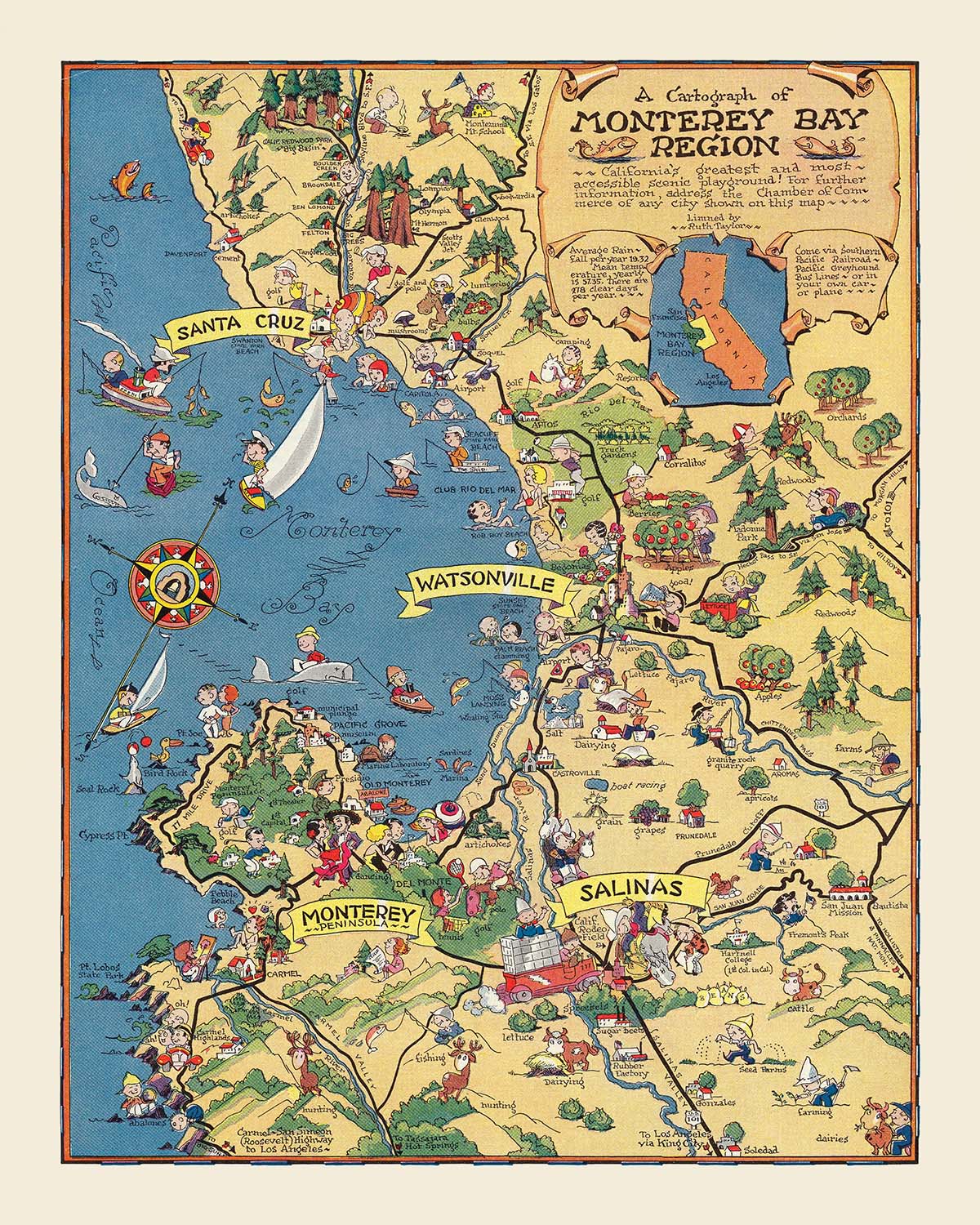
Step into the vibrant world of early 20th-century California with “A Cartograph of Monterey Bay Region,” masterfully illustrated by Ruth Taylor White...
Continue readingStep into the vibrant world of early 20th-century California with “A Cartograph of Monterey Bay Region,” masterfully illustrated by Ruth Taylor White in 1932. This exquisite pictorial map captures the allure of the Monterey Bay coastline, stretching from Santa Cruz to Salinas, and offers a delightful window into the region’s dynamic history and culture. White’s signature style—characterized by whimsical figures, bright colors, and playful captions—transforms the map into a lively tableau, where the landscape’s natural beauty and human enterprise are brought vividly to life.
The map’s historical significance is rooted in its role as both a travel guide and a promotional artifact. Commissioned by the L. & W. Land Company, a leading force in the agricultural development of the Rajaro Valley, the map highlights the area’s booming lettuce industry and its critical role in shaping the local economy. Through charming illustrations of lush fields, bustling towns, and hardworking figures, the map celebrates the agricultural heritage that defined the region during the Great Depression era—a period when California’s fertile valleys were becoming the nation’s breadbasket.
Beyond its agricultural focus, the map is a celebration of the Monterey Bay region’s rich tapestry of communities and landscapes. Major towns such as Santa Cruz, Monterey, Salinas, and Carmel are depicted with affectionate detail, while the Santa Cruz Mountains, Salinas River, and the dramatic Pacific coastline provide a stunning natural backdrop. The map’s pictorial style offers not only geographical orientation but also a sense of the vibrant daily life and recreational pursuits that made the area a magnet for visitors and settlers alike.
Transportation is a central theme, with the map’s top right corner featuring imaginative text art inviting travelers to explore the region by train, bus, automobile, or even airplane—a nod to the transformative impact of modern mobility in the 1930s. The inclusion of Southern Pacific Railroad routes, highways, and local roads reflects the era’s burgeoning tourism industry and the growing accessibility of California’s scenic wonders. These details underscore the region’s emergence as a premier destination for both leisure and commerce.
“A Cartograph of Monterey Bay Region” is more than a map—it is a historical document, a work of art, and a celebration of a pivotal era in California’s development. It captures the optimism, ingenuity, and community spirit that defined the Monterey Bay area in the early 20th century. Whether you are a collector, a historian, or an admirer of fine cartography, this map offers a captivating glimpse into the past, where every illustrated detail tells a story of place, people, and progress.
Places on this map
- Santa Cruz
- Capitola
- Watsonville
- Moss Landing
- Castroville
- Salinas
- Monterey
- Pacific Grove
- Carmel (Carmel-by-the-Sea)
- Seaside
- Marina
- Pajaro
- Spreckels
- Soledad
- Gonzales
- Chualar
- Salinas River
- Rajaro Valley
- Monterey Bay
- Santa Cruz Mountains
Notable Features & Landmarks
- Title cartouche reading “A Cartograph of Monterey Bay Region.”
- Brightly colored illustrations of the coastline, ocean, and inland areas.
- Cartoon figures representing local activities (e.g., fishing, agriculture, recreation).
- Illustrations of lettuce fields, highlighting the region’s agricultural focus.
- Whimsical text art in the top right corner promoting travel by train, bus, car, or plane.
- Compass rose for orientation.
- Small inset location map showing the region’s position within California.
- Labeled transportation routes, including the Southern Pacific Railroad.
- Pictorial depictions of local wildlife and marine life in Monterey Bay.
- Illustrations of boats and ships in the bay.
- Depictions of notable buildings and landmarks (e.g., missions, lighthouses).
- Representation of the Santa Cruz Mountains and other geographic features.
- Artistic renderings of the coastline, beaches, and cliffs.
- Visual emphasis on the agricultural richness of the Salinas Valley.
- Decorative border elements enhancing the map’s visual appeal.
- Inclusion of local recreational activities such as golfing and horseback riding.
- Artistic depiction of the Pacific Ocean with labeled “Monterey Bay.”
- Notations of major highways and roads of the period.
- Playful, informative captions throughout the map.
- Emphasis on the region’s accessibility and appeal to tourists and travelers.
- Visual references to the area’s Spanish and Mexican heritage (e.g., missions).
- Inclusion of local flora and fauna in the illustrations.
- Artistic representation of the region’s rolling hills and valleys.
- Prominent labeling of the Rajaro Valley (noted for lettuce production).
- Depiction of the Salinas River.
- Illustrations of local festivals or community gatherings.
- Visual references to fishing and canning industries.
- Labeled beaches and coastal features.
- Artistic rendering of the transition from coastal to inland agricultural areas.
Historical and design context
- Created in 1932 by Ruth Taylor White, a noted American illustrator known for her vibrant and whimsical pictorial maps.
- Produced for L. & W. Land Company, a business specializing in the cultivation and shipping of agricultural produce, especially lettuce from the Rajaro Valley.
- The map is a pictorial and thematic representation, highlighting the region’s attractions, activities, and agricultural significance.
- Features bright, engaging colors and charming cartoon-like figures, characteristic of Ruth Taylor White’s work.
- Includes a decorative title cartouche, a compass rose, and a small location map for orientation.
- Created during a period of regional growth and agricultural development in California; serves both as a promotional tool and a historical artifact reflecting the era’s travel and economic trends.
- Offers insight into the historical geography, tourism, and agricultural marketing of the Monterey Bay area in the early 20th century.
- The map’s pictorial style was popular in the 1920s and 1930s, aiming to make geography accessible and entertaining.
- Reflects the importance of agriculture (especially lettuce) to the local economy, as promoted by the L. & W. Land Company.
- The map is historically informative, capturing the look, feel, and activities of the region during the early 1930s.
- The map is not to scale and is intended for illustrative and promotional purposes rather than precise navigation.
- A valuable artifact for those interested in California’s regional development, tourism history, and agricultural heritage.
Please double check the images to make sure that a specific town or place is shown on this map. You can also get in touch and ask us to check the map for you.
This map looks great at every size, but I always recommend going for a larger size if you have space. That way you can easily make out all of the details.
This map looks amazing at sizes all the way up to 50in (125cm). If you are looking for a larger map, please get in touch.
The model in the listing images is holding the 16x20in (40x50cm) version of this map.
The fifth listing image shows an example of my map personalisation service.
If you’re looking for something slightly different, check out my collection of the best old maps to see if something else catches your eye.
Please contact me to check if a certain location, landmark or feature is shown on this map.
This would make a wonderful birthday, Christmas, Father's Day, work leaving, anniversary or housewarming gift for someone from the areas covered by this map.
This map is available as a giclée print on acid free archival matte paper, or you can buy it framed. The frame is a nice, simple black frame that suits most aesthetics. Please get in touch if you'd like a different frame colour or material. My frames are glazed with super-clear museum-grade acrylic (perspex/acrylite), which is significantly less reflective than glass, safer, and will always arrive in perfect condition.
This map is also available as a float framed canvas, sometimes known as a shadow gap framed canvas or canvas floater. The map is printed on artist's cotton canvas and then stretched over a handmade box frame. We then "float" the canvas inside a wooden frame, which is available in a range of colours (black, dark brown, oak, antique gold and white). This is a wonderful way to present a map without glazing in front. See some examples of float framed canvas maps and explore the differences between my different finishes.
For something truly unique, this map is also available in "Unique 3D", our trademarked process that dramatically transforms the map so that it has a wonderful sense of depth. We combine the original map with detailed topography and elevation data, so that mountains and the terrain really "pop". For more info and examples of 3D maps, check my Unique 3D page.
Step into the vibrant world of early 20th-century California with “A Cartograph of Monterey Bay Region,” masterfully illustrated by Ruth Taylor White in 1932. This exquisite pictorial map captures the allure of the Monterey Bay coastline, stretching from Santa Cruz to Salinas, and offers a delightful window into the region’s dynamic history and culture. White’s signature style—characterized by whimsical figures, bright colors, and playful captions—transforms the map into a lively tableau, where the landscape’s natural beauty and human enterprise are brought vividly to life.
The map’s historical significance is rooted in its role as both a travel guide and a promotional artifact. Commissioned by the L. & W. Land Company, a leading force in the agricultural development of the Rajaro Valley, the map highlights the area’s booming lettuce industry and its critical role in shaping the local economy. Through charming illustrations of lush fields, bustling towns, and hardworking figures, the map celebrates the agricultural heritage that defined the region during the Great Depression era—a period when California’s fertile valleys were becoming the nation’s breadbasket.
Beyond its agricultural focus, the map is a celebration of the Monterey Bay region’s rich tapestry of communities and landscapes. Major towns such as Santa Cruz, Monterey, Salinas, and Carmel are depicted with affectionate detail, while the Santa Cruz Mountains, Salinas River, and the dramatic Pacific coastline provide a stunning natural backdrop. The map’s pictorial style offers not only geographical orientation but also a sense of the vibrant daily life and recreational pursuits that made the area a magnet for visitors and settlers alike.
Transportation is a central theme, with the map’s top right corner featuring imaginative text art inviting travelers to explore the region by train, bus, automobile, or even airplane—a nod to the transformative impact of modern mobility in the 1930s. The inclusion of Southern Pacific Railroad routes, highways, and local roads reflects the era’s burgeoning tourism industry and the growing accessibility of California’s scenic wonders. These details underscore the region’s emergence as a premier destination for both leisure and commerce.
“A Cartograph of Monterey Bay Region” is more than a map—it is a historical document, a work of art, and a celebration of a pivotal era in California’s development. It captures the optimism, ingenuity, and community spirit that defined the Monterey Bay area in the early 20th century. Whether you are a collector, a historian, or an admirer of fine cartography, this map offers a captivating glimpse into the past, where every illustrated detail tells a story of place, people, and progress.
Places on this map
- Santa Cruz
- Capitola
- Watsonville
- Moss Landing
- Castroville
- Salinas
- Monterey
- Pacific Grove
- Carmel (Carmel-by-the-Sea)
- Seaside
- Marina
- Pajaro
- Spreckels
- Soledad
- Gonzales
- Chualar
- Salinas River
- Rajaro Valley
- Monterey Bay
- Santa Cruz Mountains
Notable Features & Landmarks
- Title cartouche reading “A Cartograph of Monterey Bay Region.”
- Brightly colored illustrations of the coastline, ocean, and inland areas.
- Cartoon figures representing local activities (e.g., fishing, agriculture, recreation).
- Illustrations of lettuce fields, highlighting the region’s agricultural focus.
- Whimsical text art in the top right corner promoting travel by train, bus, car, or plane.
- Compass rose for orientation.
- Small inset location map showing the region’s position within California.
- Labeled transportation routes, including the Southern Pacific Railroad.
- Pictorial depictions of local wildlife and marine life in Monterey Bay.
- Illustrations of boats and ships in the bay.
- Depictions of notable buildings and landmarks (e.g., missions, lighthouses).
- Representation of the Santa Cruz Mountains and other geographic features.
- Artistic renderings of the coastline, beaches, and cliffs.
- Visual emphasis on the agricultural richness of the Salinas Valley.
- Decorative border elements enhancing the map’s visual appeal.
- Inclusion of local recreational activities such as golfing and horseback riding.
- Artistic depiction of the Pacific Ocean with labeled “Monterey Bay.”
- Notations of major highways and roads of the period.
- Playful, informative captions throughout the map.
- Emphasis on the region’s accessibility and appeal to tourists and travelers.
- Visual references to the area’s Spanish and Mexican heritage (e.g., missions).
- Inclusion of local flora and fauna in the illustrations.
- Artistic representation of the region’s rolling hills and valleys.
- Prominent labeling of the Rajaro Valley (noted for lettuce production).
- Depiction of the Salinas River.
- Illustrations of local festivals or community gatherings.
- Visual references to fishing and canning industries.
- Labeled beaches and coastal features.
- Artistic rendering of the transition from coastal to inland agricultural areas.
Historical and design context
- Created in 1932 by Ruth Taylor White, a noted American illustrator known for her vibrant and whimsical pictorial maps.
- Produced for L. & W. Land Company, a business specializing in the cultivation and shipping of agricultural produce, especially lettuce from the Rajaro Valley.
- The map is a pictorial and thematic representation, highlighting the region’s attractions, activities, and agricultural significance.
- Features bright, engaging colors and charming cartoon-like figures, characteristic of Ruth Taylor White’s work.
- Includes a decorative title cartouche, a compass rose, and a small location map for orientation.
- Created during a period of regional growth and agricultural development in California; serves both as a promotional tool and a historical artifact reflecting the era’s travel and economic trends.
- Offers insight into the historical geography, tourism, and agricultural marketing of the Monterey Bay area in the early 20th century.
- The map’s pictorial style was popular in the 1920s and 1930s, aiming to make geography accessible and entertaining.
- Reflects the importance of agriculture (especially lettuce) to the local economy, as promoted by the L. & W. Land Company.
- The map is historically informative, capturing the look, feel, and activities of the region during the early 1930s.
- The map is not to scale and is intended for illustrative and promotional purposes rather than precise navigation.
- A valuable artifact for those interested in California’s regional development, tourism history, and agricultural heritage.
Please double check the images to make sure that a specific town or place is shown on this map. You can also get in touch and ask us to check the map for you.
This map looks great at every size, but I always recommend going for a larger size if you have space. That way you can easily make out all of the details.
This map looks amazing at sizes all the way up to 50in (125cm). If you are looking for a larger map, please get in touch.
The model in the listing images is holding the 16x20in (40x50cm) version of this map.
The fifth listing image shows an example of my map personalisation service.
If you’re looking for something slightly different, check out my collection of the best old maps to see if something else catches your eye.
Please contact me to check if a certain location, landmark or feature is shown on this map.
This would make a wonderful birthday, Christmas, Father's Day, work leaving, anniversary or housewarming gift for someone from the areas covered by this map.
This map is available as a giclée print on acid free archival matte paper, or you can buy it framed. The frame is a nice, simple black frame that suits most aesthetics. Please get in touch if you'd like a different frame colour or material. My frames are glazed with super-clear museum-grade acrylic (perspex/acrylite), which is significantly less reflective than glass, safer, and will always arrive in perfect condition.
This map is also available as a float framed canvas, sometimes known as a shadow gap framed canvas or canvas floater. The map is printed on artist's cotton canvas and then stretched over a handmade box frame. We then "float" the canvas inside a wooden frame, which is available in a range of colours (black, dark brown, oak, antique gold and white). This is a wonderful way to present a map without glazing in front. See some examples of float framed canvas maps and explore the differences between my different finishes.
For something truly unique, this map is also available in "Unique 3D", our trademarked process that dramatically transforms the map so that it has a wonderful sense of depth. We combine the original map with detailed topography and elevation data, so that mountains and the terrain really "pop". For more info and examples of 3D maps, check my Unique 3D page.
Many of our maps and art prints are chosen as thoughtful gifts for homes, offices, studies and meaningful places.
Choose a framed option for the easiest ready-to-hang gift, or choose an unframed print if the recipient may prefer to select their own frame.
We make orders locally in 23 countries around the world, so gifts can often be produced close to the recipient. This helps them arrive faster, travel more safely, and avoid customs or import duty surprises.
- We can deliver directly to the recipient
- Framed pieces arrive ready to hang
- Unframed prints are carefully packed in a strong protective tube
- Almost every order is made locally, for faster, safer gifting
- 90-day returns give the recipient time to decide
If you are not sure what to choose, please contact us. We can help you pick the right map, size, finish or delivery option.
Most orders are made locally and delivered in around 2–3 working days, depending on the product, size and destination.
We print and frame maps and artwork in 23 countries around the world, so your order is usually made close to you or your recipient. That means faster delivery, less time in transit, and no customs or import duty surprises.
Personalised and customised pieces usually take an extra 1–2 working days, because we prepare your design and send it to you for approval before printing.
Very large framed orders can take a little longer, as they need extra care in production and delivery.
Every order is carefully packaged: unframed prints are sent in a strong protective tube, while framed pieces are securely packed with protective materials around the frame.
If you need your order by a particular date, please contact us before ordering. We’ll check the best production route and delivery option for your location.
Express delivery is available at checkout for most countries. Next-day delivery is available in the UK, US, Singapore and the UAE.
Your order is covered by our 90-day returns policy and 10-year guarantee.
Our standard frame is a gallery-style black ash hardwood frame, with a simple, modern look. It is approximately 20mm (0.8in) wide. You can also view some lovely customer photos of framed maps and art.
We use super-clear acrylic glazing, also known as Perspex or Acrylite, instead of traditional glass. It is lighter, safer, and has lower reflectivity, giving the artwork a clearer, cleaner appearance.
Six standard frame colours are available at no extra cost: black, dark brown, dark grey, oak, white, and antique gold. Custom framing and mounting/matting is also available for customers looking for something more specific.
Most maps, art prints, and illustrations are also available as a framed canvas. We use matte cotton canvas, stretch it over a sustainably sourced wooden box frame, and then float the piece within a wooden outer frame. The finished result is beautifully presented, with no glazing between you and the artwork.
All frames are supplied ready to hang, with either string or brackets fitted to the back. Very large frames will include heavy-duty hanging plates and/or a mounting baton. If you have any questions, please get in touch.
We can also supply old maps and artwork on canvas, foam board, cotton rag, and other materials.
If you would prefer to frame your map or artwork yourself, please read our size guide before ordering.
My maps are extremely high quality reproductions of original maps.
I source original, rare maps from libraries, auction houses and private collections around the world, restore them at my London workshop, and then use specialist giclée inks and printers to create beautiful maps that look even better than the original.
My maps are printed on acid-free archival matte (not glossy) paper that feels very high quality and almost like card. In technical terms the paper weight/thickness is 10mil/200gsm. It's perfect for framing.
I print with Epson ultrachrome giclée UV fade resistant pigment inks - some of the best inks you can find.
I can also make maps on canvas, cotton rag and other exotic materials.
Learn more about The Unique Maps Co.
Map personalisation
If you're looking for the perfect anniversary or housewarming gift, I can personalise your map to make it truly unique. For example, I can add a short message, or highlight an important location, or add your family's coat of arms.
The options are almost infinite. Please see my map personalisation page for some wonderful examples of what's possible.
To order a personalised map, select "personalise your map" before adding it to your basket.
Get in touch if you're looking for more complex customisations and personalisations.
Map ageing
I have been asked hundreds of times over the years by customers if they could buy a map that looks even older.
Well, now you can, by selecting Aged before you add a map to your basket.
All the product photos you see on this page show the map in its Original form. This is what the map looks like today.
If you select Aged, I will age your map by hand, using a special and unique process developed through years of studying old maps, talking to researchers to understand the chemistry of aging paper, and of course... lots of practice!
If you're unsure, stick to the Original colour of the map. If you want something a bit darker and older looking, go for Aged.
If you are not happy with your order for any reason, contact me and I'll get it fixed ASAP, free of charge. Please see my returns and refund policy for more information.
I am very confident you will like your restored map or art print. I have been doing this since 1984. I'm a 5-star Etsy seller. I have sold tens of thousands of maps and art prints and have over 5,000 real 5-star reviews. My work has been featured in interior design magazines, on the BBC, and on the walls of dozens of 5-star hotels.
I use a unique process to restore maps and artwork that is massively time consuming and labour intensive. Hunting down the original maps and illustrations can take months. I use state of the art and eye-wateringly expensive technology to scan and restore them. As a result, I guarantee my maps and art prints are a cut above the rest. I stand by my products and will always make sure you're 100% happy with what you receive.
Almost all of my maps and art prints look amazing at large sizes (200cm, 6.5ft+) and I can frame and deliver them to you as well, via special oversized courier. Contact me to discuss your specific needs.
Or try searching for something!


