

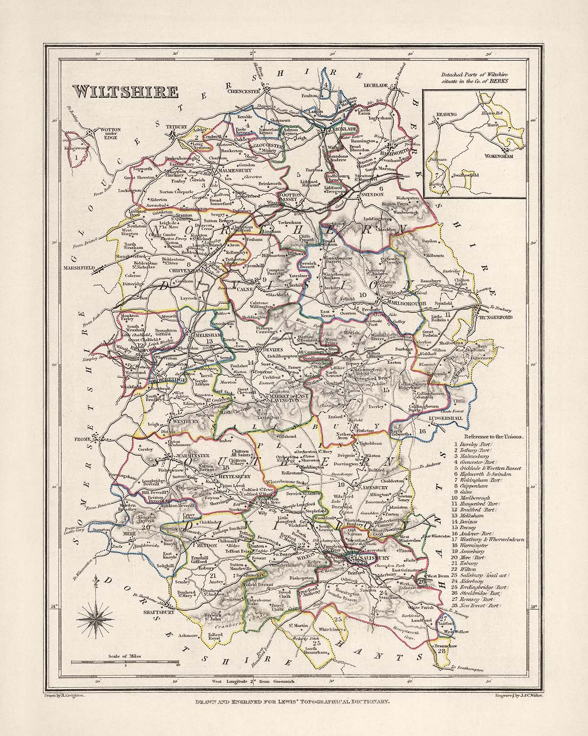


Rare Old Map of Wiltshire by Samuel Lewis, 1844: Salisbury, Devizes, Marlborough, Chippenham, Stonehenge
The Collector’s Offer
Choose two eligible works and receive 20% off both. Choose three and the lowest-priced one is complimentary, a maximum saving of 33%.
Mix and match eligible standard maps and fine-art prints. No code is required; the offer is applied automatically at checkout.
Standard made-to-order configurations are included. Bespoke sizes, personalised designs and commissioned work are excluded.
Need delivery to different addresses? Contact us before ordering.The Collector’s Offer
Choose two eligible works and receive 20% off both. Choose three and the lowest-priced one is complimentary, a maximum saving of 33%.
Mix and match eligible standard maps and fine-art prints. No code is required; the offer is applied automatically at checkout.
Standard made-to-order configurations are included. Bespoke sizes, personalised designs and commissioned work are excluded.
Need delivery to different addresses? Contact us before ordering. Designed in London Made in the UK
Designed in London • Made in the UK
Designed in London Made in the UK
Designed in London • Made in the UK

Restored from the original 1844 map and printed to museum-grade archival standards. Read the story behind this map
Choose your size
Choose your finish


(More info)
Gift message & custom finish

If you want to add a gift message, or a finish (jigsaw, aluminium board, etc.) that is not available here, please request it in the "order note" when you check out.
Every order is custom made, so if you need the size adjusted slightly, or printed on an unusual material, just let us know. We've done thousands of custom orders over the years, so there's (almost) nothing we can't manage.
You can also contact us before you order, if you prefer!

- Made locally for fast, safe delivery
- No import duty or hidden fees
- Need advice? Call us or message on WhatsApp
Own a piece of history
8,000+ five-star reviews


This Old Map of Wiltshire, created by Samuel Lewis in 1844, offers a fascinating glimpse into the historical landscape of the county....
Continue readingThis Old Map of Wiltshire, created by Samuel Lewis in 1844, offers a fascinating glimpse into the historical landscape of the county. With its intricate details and exquisite craftsmanship, this map is a true collector's item for history enthusiasts and map aficionados alike.
Featuring the County of Wiltshire in the mid-19th century, this map showcases the region's main towns, cities, and other captivating features. It is important to note that while some modern cities may not be depicted on this map, it provides a unique opportunity to explore earlier names and settlements.
Notable for its historical accuracy, this map allows you to immerse yourself in the past and discover the rich heritage of Wiltshire. Whether you're tracing the evolution of towns or marveling at the intricate cartographic details, this map offers a captivating journey through time.
Settlements Founded Before 1840 within the Historical Boundaries of County of Wiltshire, England:
- Salisbury (1220): The historic city of Salisbury is renowned for its magnificent cathedral, which dates back to the 13th century.
- Devizes (1086): Devizes is a market town with a rich medieval history, known for its impressive 11th-century castle.
- Marlborough (1067): Home to the famous Marlborough College, this town boasts a charming high street lined with historic buildings.
- Chippenham (600s): Chippenham is a market town that traces its roots back to the Anglo-Saxon era, with a history steeped in trade and industry.
Stonehenge (3000 BC): This iconic prehistoric monument, shrouded in mystery, is a UNESCO World Heritage Site and a testament to ancient engineering.
Trowbridge (1200): Trowbridge is the county town of Wiltshire and has a rich textile heritage, once being a major center for wool production.
- Warminster (900s): Warminster is known for its beautiful surrounding countryside and the enchanting Longleat House, an Elizabethan stately home.
- Melksham (700s): Melksham is a historic market town that flourished during the Middle Ages, with remnants of its medieval past still visible today.
- Amesbury (979): Amesbury is one of the oldest continuously inhabited settlements in England and is located near the iconic Stonehenge.
Calne (978): Calne is a charming town with a long history, known for its picturesque river and the historic Atwell-Wilson Motor Museum.
Westbury (800s): Westbury is a small town with a rich history, featuring the impressive Westbury White Horse, a hillside chalk figure.
- Corsham (900s): Corsham is a delightful market town with a wealth of historic buildings, including the grand Corsham Court.
- Devizes Castle (1080): Devizes Castle, founded shortly after the Norman Conquest, played a significant role in the region's medieval history.
- Bradford-on-Avon (600s): Bradford-on-Avon is a charming town with well-preserved medieval buildings, including the stunning Saxon Church.
Malmesbury (600s): Malmesbury is an ancient hilltop town with a rich history, including its famous abbey and connections to King Athelstan.
Royal Wootton Bassett (700s): Royal Wootton Bassett is a historic market town known for its connections to the military and its respectful repatriation processions.
- Cricklade (800s): Cricklade is a small town with a rich Saxon history, featuring the well-preserved St. Sampson's Church.
- Durrington (600s): Durrington is an ancient settlement located near Stonehenge, with archaeological evidence of its Neolithic past.
- Pewsey (900s): Pewsey is a picturesque village nestled in the heart of the Pewsey Vale, surrounded by the stunning Wiltshire Downs.
Ramsbury (800s): Ramsbury is a charming village with a rich history, including its historic abbey and the Ramsbury Brewery.
Box (600s): Box is a village known for its stone quarries, which provided the famous Bath Stone used in many historic buildings.
- Lyneham (800s): Lyneham is a village with a strong military presence, hosting the Royal Air Force's largest transport base.
- Holt (1200s): Holt is a quaint village with a medieval bridge and a fascinating history intertwined with the nearby town of Bradford-on-Avon.
- Tisbury (700s): Tisbury is a picturesque village surrounded by beautiful countryside, with a rich history dating back to Saxon times.
Wroughton (800s): Wroughton is a village located on the edge of the Marlborough Downs, known for its annual steam fair.
Wilton (800s): Wilton is a historic town with strong royal connections, featuring the magnificent Wilton House and its beautiful gardens.
- Great Bedwyn (800s): Great Bedwyn is a charming village situated along the Kennet and Avon Canal, offering scenic walks and historic sites.
- Market Lavington (800s): Market Lavington is a village with a rich agricultural heritage, once hosting one of the largest sheep fairs in the country.
- Brinkworth (800s): Brinkworth is a village steeped in history, known for its impressive medieval church and picturesque rural surroundings.
- Avebury (2600 BC): Avebury is home to the largest stone circle in Europe, forming part of a Neolithic landscape that captivates visitors.
Notable Boundaries, Rivers, and Natural Phenomena:
- River Avon: The River Avon meanders through the county, offering picturesque landscapes and opportunities for leisurely walks.
- Salisbury Plain: This vast chalk plateau is renowned for its archaeological sites, including the enigmatic Stonehenge and other ancient monuments.
- Cranborne Chase: Located in the southeastern part of the county, Cranborne Chase is an Area of Outstanding Natural Beauty, offering stunning landscapes and rich biodiversity.
- Pewsey Vale: The Pewsey Vale is a picturesque valley known for its rolling hills, charming villages, and tranquil waterways.
Historical Events in County of Wiltshire, England (1800-1850):
- Battle of Trafalgar (1805): Although not directly related to Wiltshire, the Battle of Trafalgar, fought off the coast of Spain, had a significant impact on British naval dominance during this period.
- Great Reform Act (1832): The passing of the Great Reform Act in 1832 brought about electoral reforms, reshaping the political landscape of the country, including Wiltshire.
- Railways Expansion: The mid-19th century witnessed the expansion of railways throughout England, including the construction of several railway lines in Wiltshire, facilitating trade and travel.
Own a piece of history with this Old Map of Wiltshire by Samuel Lewis, 1844. Immerse yourself in the rich heritage of the county, explore its captivating towns and cities, and marvel at the intricate details of this historical cartographic masterpiece.
Please double check the images to make sure that a specific town or place is shown on this map. You can also get in touch and ask us to check the map for you.
This map looks great at all sizes: 12x16in (30.5x41cm), 16x20in (40.5x51cm), 18x24in (45.5x61cm), 24x30in (61x76cm), 32x40in (81.5x102cm) and 40x50in (102x127cm), but it looks even better when printed large.
I can create beautiful, large prints of this map up to 50in (127cm). Please get in touch if you're looking for larger, customised or different framing options.
The model in the listing images is holding the 16x20in (40.5x51cm) version of this map.
The fifth listing image shows an example of my map personalisation service.
If you’re looking for something slightly different, check out my main collection of UK and Ireland maps.
Please contact me to check if a certain location, landmark or feature is shown on this map.
This would make a wonderful birthday, Christmas, Father's Day, work leaving, anniversary or housewarming gift for someone from the areas covered by this map.
This map is available as a giclée print on acid free archival matte paper, or you can buy it framed. The frame is a nice, simple black frame that suits most aesthetics. Please get in touch if you'd like a different frame colour or material. My frames are glazed with super-clear museum-grade acrylic (perspex/acrylite), which is significantly less reflective than glass, safer, and will always arrive in perfect condition.
This map is also available as a float framed canvas, sometimes known as a shadow gap framed canvas or canvas floater. The map is printed on artist's cotton canvas and then stretched over a handmade box frame. We then "float" the canvas inside a wooden frame, which is available in a range of colours (black, dark brown, oak, antique gold and white). This is a wonderful way to present a map without glazing in front. See some examples of float framed canvas maps and explore the differences between my different finishes.
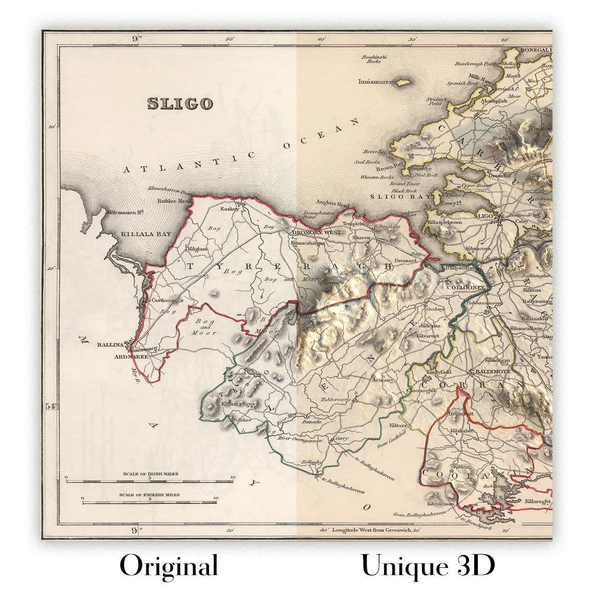
For something truly unique, this map is also available in "Unique 3D", our trademarked process that dramatically transforms the map so that it has a wonderful sense of depth. We combine the original map with detailed topography and elevation data, so that mountains and the terrain really "pop". For more info and examples of 3D maps, check my Unique 3D page.
This Old Map of Wiltshire, created by Samuel Lewis in 1844, offers a fascinating glimpse into the historical landscape of the county. With its intricate details and exquisite craftsmanship, this map is a true collector's item for history enthusiasts and map aficionados alike.
Featuring the County of Wiltshire in the mid-19th century, this map showcases the region's main towns, cities, and other captivating features. It is important to note that while some modern cities may not be depicted on this map, it provides a unique opportunity to explore earlier names and settlements.
Notable for its historical accuracy, this map allows you to immerse yourself in the past and discover the rich heritage of Wiltshire. Whether you're tracing the evolution of towns or marveling at the intricate cartographic details, this map offers a captivating journey through time.
Settlements Founded Before 1840 within the Historical Boundaries of County of Wiltshire, England:
- Salisbury (1220): The historic city of Salisbury is renowned for its magnificent cathedral, which dates back to the 13th century.
- Devizes (1086): Devizes is a market town with a rich medieval history, known for its impressive 11th-century castle.
- Marlborough (1067): Home to the famous Marlborough College, this town boasts a charming high street lined with historic buildings.
- Chippenham (600s): Chippenham is a market town that traces its roots back to the Anglo-Saxon era, with a history steeped in trade and industry.
Stonehenge (3000 BC): This iconic prehistoric monument, shrouded in mystery, is a UNESCO World Heritage Site and a testament to ancient engineering.
Trowbridge (1200): Trowbridge is the county town of Wiltshire and has a rich textile heritage, once being a major center for wool production.
- Warminster (900s): Warminster is known for its beautiful surrounding countryside and the enchanting Longleat House, an Elizabethan stately home.
- Melksham (700s): Melksham is a historic market town that flourished during the Middle Ages, with remnants of its medieval past still visible today.
- Amesbury (979): Amesbury is one of the oldest continuously inhabited settlements in England and is located near the iconic Stonehenge.
Calne (978): Calne is a charming town with a long history, known for its picturesque river and the historic Atwell-Wilson Motor Museum.
Westbury (800s): Westbury is a small town with a rich history, featuring the impressive Westbury White Horse, a hillside chalk figure.
- Corsham (900s): Corsham is a delightful market town with a wealth of historic buildings, including the grand Corsham Court.
- Devizes Castle (1080): Devizes Castle, founded shortly after the Norman Conquest, played a significant role in the region's medieval history.
- Bradford-on-Avon (600s): Bradford-on-Avon is a charming town with well-preserved medieval buildings, including the stunning Saxon Church.
Malmesbury (600s): Malmesbury is an ancient hilltop town with a rich history, including its famous abbey and connections to King Athelstan.
Royal Wootton Bassett (700s): Royal Wootton Bassett is a historic market town known for its connections to the military and its respectful repatriation processions.
- Cricklade (800s): Cricklade is a small town with a rich Saxon history, featuring the well-preserved St. Sampson's Church.
- Durrington (600s): Durrington is an ancient settlement located near Stonehenge, with archaeological evidence of its Neolithic past.
- Pewsey (900s): Pewsey is a picturesque village nestled in the heart of the Pewsey Vale, surrounded by the stunning Wiltshire Downs.
Ramsbury (800s): Ramsbury is a charming village with a rich history, including its historic abbey and the Ramsbury Brewery.
Box (600s): Box is a village known for its stone quarries, which provided the famous Bath Stone used in many historic buildings.
- Lyneham (800s): Lyneham is a village with a strong military presence, hosting the Royal Air Force's largest transport base.
- Holt (1200s): Holt is a quaint village with a medieval bridge and a fascinating history intertwined with the nearby town of Bradford-on-Avon.
- Tisbury (700s): Tisbury is a picturesque village surrounded by beautiful countryside, with a rich history dating back to Saxon times.
Wroughton (800s): Wroughton is a village located on the edge of the Marlborough Downs, known for its annual steam fair.
Wilton (800s): Wilton is a historic town with strong royal connections, featuring the magnificent Wilton House and its beautiful gardens.
- Great Bedwyn (800s): Great Bedwyn is a charming village situated along the Kennet and Avon Canal, offering scenic walks and historic sites.
- Market Lavington (800s): Market Lavington is a village with a rich agricultural heritage, once hosting one of the largest sheep fairs in the country.
- Brinkworth (800s): Brinkworth is a village steeped in history, known for its impressive medieval church and picturesque rural surroundings.
- Avebury (2600 BC): Avebury is home to the largest stone circle in Europe, forming part of a Neolithic landscape that captivates visitors.
Notable Boundaries, Rivers, and Natural Phenomena:
- River Avon: The River Avon meanders through the county, offering picturesque landscapes and opportunities for leisurely walks.
- Salisbury Plain: This vast chalk plateau is renowned for its archaeological sites, including the enigmatic Stonehenge and other ancient monuments.
- Cranborne Chase: Located in the southeastern part of the county, Cranborne Chase is an Area of Outstanding Natural Beauty, offering stunning landscapes and rich biodiversity.
- Pewsey Vale: The Pewsey Vale is a picturesque valley known for its rolling hills, charming villages, and tranquil waterways.
Historical Events in County of Wiltshire, England (1800-1850):
- Battle of Trafalgar (1805): Although not directly related to Wiltshire, the Battle of Trafalgar, fought off the coast of Spain, had a significant impact on British naval dominance during this period.
- Great Reform Act (1832): The passing of the Great Reform Act in 1832 brought about electoral reforms, reshaping the political landscape of the country, including Wiltshire.
- Railways Expansion: The mid-19th century witnessed the expansion of railways throughout England, including the construction of several railway lines in Wiltshire, facilitating trade and travel.
Own a piece of history with this Old Map of Wiltshire by Samuel Lewis, 1844. Immerse yourself in the rich heritage of the county, explore its captivating towns and cities, and marvel at the intricate details of this historical cartographic masterpiece.
Please double check the images to make sure that a specific town or place is shown on this map. You can also get in touch and ask us to check the map for you.
This map looks great at all sizes, but it looks even better when printed large.
I can create beautiful, large prints of this map up to 50in (127cm). Please get in touch if you're looking for larger, customised or different framing options.
The model in the listing images is holding the 16x20in (40.5x51cm) version of this map.
The fifth listing image shows an example of my map personalisation service.
If you’re looking for something slightly different, check out my main collection of UK and Ireland maps.
Please contact me to check if a certain location, landmark or feature is shown on this map.
This would make a wonderful birthday, Christmas, Father's Day, work leaving, anniversary or housewarming gift for someone from the areas covered by this map.
This map is available as a giclée print on acid free archival matte paper, or you can buy it framed. The frame is a nice, simple black frame that suits most aesthetics. Please get in touch if you'd like a different frame colour or material. My frames are glazed with super-clear museum-grade acrylic (perspex/acrylite), which is significantly less reflective than glass, safer, and will always arrive in perfect condition.
This map is also available as a float framed canvas, sometimes known as a shadow gap framed canvas or canvas floater. The map is printed on artist's cotton canvas and then stretched over a handmade box frame. We then "float" the canvas inside a wooden frame, which is available in a range of colours (black, dark brown, oak, antique gold and white). This is a wonderful way to present a map without glazing in front. See some examples of float framed canvas maps and explore the differences between my different finishes.
For something truly unique, this map is also available in "Unique 3D", our trademarked process that dramatically transforms the map so that it has a wonderful sense of depth. We combine the original map with detailed topography and elevation data, so that mountains and the terrain really "pop". For more info and examples of 3D maps, check my Unique 3D page.
Many of our maps and art prints are chosen as thoughtful gifts for homes, offices, studies and meaningful places.
Choose a framed option for the easiest ready-to-hang gift, or choose an unframed print if the recipient may prefer to select their own frame.
We make orders locally in 23 countries around the world, so gifts can often be produced close to the recipient. This helps them arrive faster, travel more safely, and avoid customs or import duty surprises.
- We can deliver directly to the recipient
- Framed pieces arrive ready to hang
- Unframed prints are carefully packed in a strong protective tube
- Almost every order is made locally, for faster, safer gifting
- 90-day returns give the recipient time to decide
If you are not sure what to choose, please contact us. We can help you pick the right map, size, finish or delivery option.
Most orders are made locally and delivered in around 2–3 working days, depending on the product, size and destination.
We print and frame maps and artwork in 23 countries around the world, so your order is usually made close to you or your recipient. That means faster delivery, less time in transit, and no customs or import duty surprises.
Personalised and customised pieces usually take an extra 1–2 working days, because we prepare your design and send it to you for approval before printing.
Very large framed orders can take a little longer, as they need extra care in production and delivery.
Every order is carefully packaged: unframed prints are sent in a strong protective tube, while framed pieces are securely packed with protective materials around the frame.
If you need your order by a particular date, please contact us before ordering. We’ll check the best production route and delivery option for your location.
Express delivery is available at checkout for most countries. Next-day delivery is available in the UK, US, Singapore and the UAE.
Your order is covered by our 90-day returns policy and 10-year guarantee.
Our standard frame is a gallery-style black ash hardwood frame, with a simple, modern look. It is approximately 20mm (0.8in) wide. You can also view some lovely customer photos of framed maps and art.
We use super-clear acrylic glazing, also known as Perspex or Acrylite, instead of traditional glass. It is lighter, safer, and has lower reflectivity, giving the artwork a clearer, cleaner appearance.
Six standard frame colours are available at no extra cost: black, dark brown, dark grey, oak, white, and antique gold. Custom framing and mounting/matting is also available for customers looking for something more specific.
Most maps, art prints, and illustrations are also available as a framed canvas. We use matte cotton canvas, stretch it over a sustainably sourced wooden box frame, and then float the piece within a wooden outer frame. The finished result is beautifully presented, with no glazing between you and the artwork.
All frames are supplied ready to hang, with either string or brackets fitted to the back. Very large frames will include heavy-duty hanging plates and/or a mounting baton. If you have any questions, please get in touch.
We can also supply old maps and artwork on canvas, foam board, cotton rag, and other materials.
If you would prefer to frame your map or artwork yourself, please read our size guide before ordering.
My maps are extremely high quality reproductions of original maps.
I source original, rare maps from libraries, auction houses and private collections around the world, restore them at my London workshop, and then use specialist giclée inks and printers to create beautiful maps that look even better than the original.
My maps are printed on acid-free archival matte (not glossy) paper that feels very high quality and almost like card. In technical terms the paper weight/thickness is 10mil/200gsm. It's perfect for framing.
I print with Epson ultrachrome giclée UV fade resistant pigment inks - some of the best inks you can find.
I can also make maps on canvas, cotton rag and other exotic materials.
Learn more about The Unique Maps Co.
Map personalisation
If you're looking for the perfect anniversary or housewarming gift, I can personalise your map to make it truly unique. For example, I can add a short message, or highlight an important location, or add your family's coat of arms.
The options are almost infinite. Please see my map personalisation page for some wonderful examples of what's possible.
To order a personalised map, select "personalise your map" before adding it to your basket.
Get in touch if you're looking for more complex customisations and personalisations.
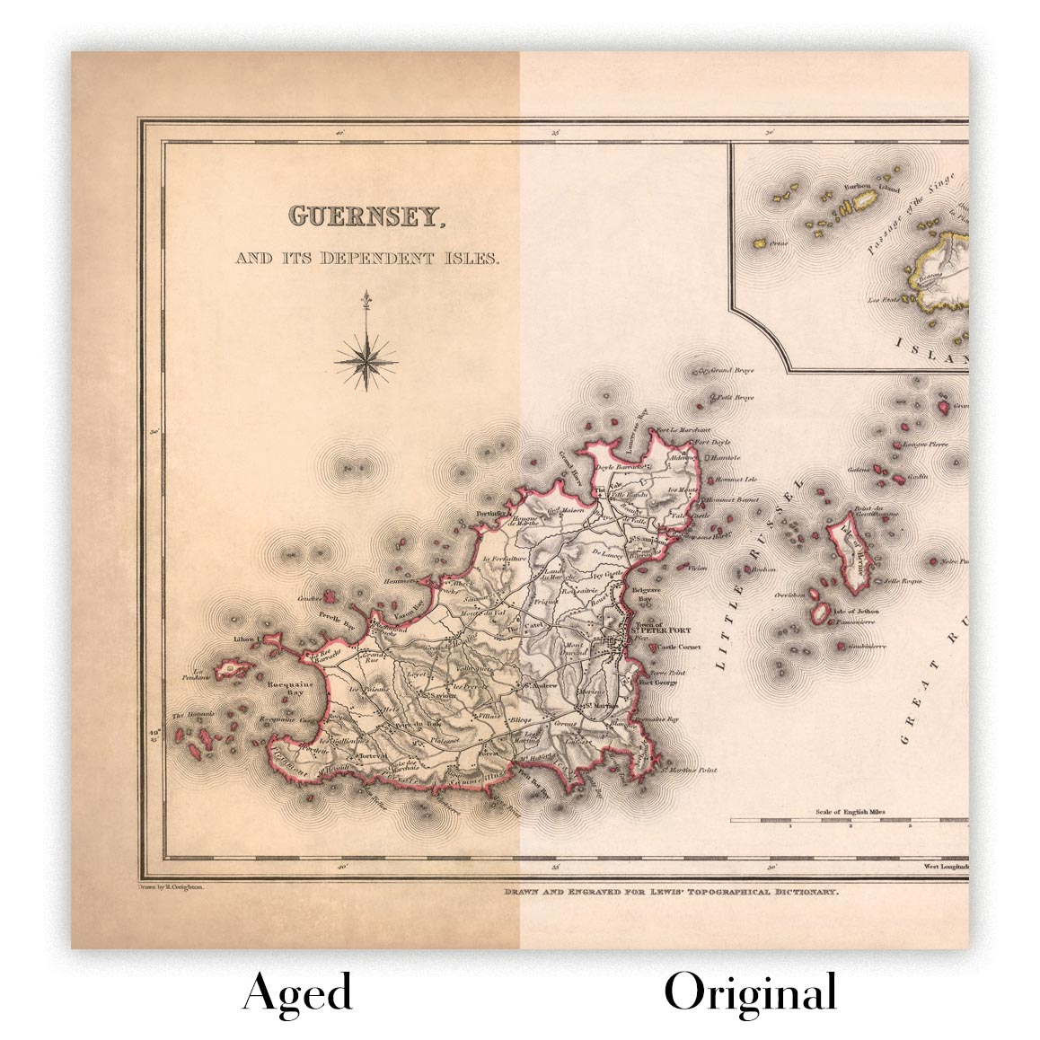
Map ageing
I have been asked hundreds of times over the years by customers if they could buy a map that looks even older.
Well, now you can, by selecting Aged before you add a map to your basket.
All the product photos you see on this page show the map in its Original form. This is what the map looks like today.
If you select Aged, I will age your map by hand, using a special and unique process developed through years of studying old maps, talking to researchers to understand the chemistry of aging paper, and of course... lots of practice!
If you're unsure, stick to the Original colour of the map. If you want something a bit darker and older looking, go for Aged.
If you are not happy with your order for any reason, contact me and I'll get it fixed ASAP, free of charge. Please see my returns and refund policy for more information.
I am very confident you will like your restored map or art print. I have been doing this since 1984. I'm a 5-star Etsy seller. I have sold tens of thousands of maps and art prints and have over 5,000 real 5-star reviews. My work has been featured in interior design magazines, on the BBC, and on the walls of dozens of 5-star hotels.
I use a unique process to restore maps and artwork that is massively time consuming and labour intensive. Hunting down the original maps and illustrations can take months. I use state of the art and eye-wateringly expensive technology to scan and restore them. As a result, I guarantee my maps and art prints are a cut above the rest. I stand by my products and will always make sure you're 100% happy with what you receive.
Almost all of my maps and art prints look amazing at large sizes (200cm, 6.5ft+) and I can frame and deliver them to you as well, via special oversized courier. Contact me to discuss your specific needs.
Or try searching for something!


