

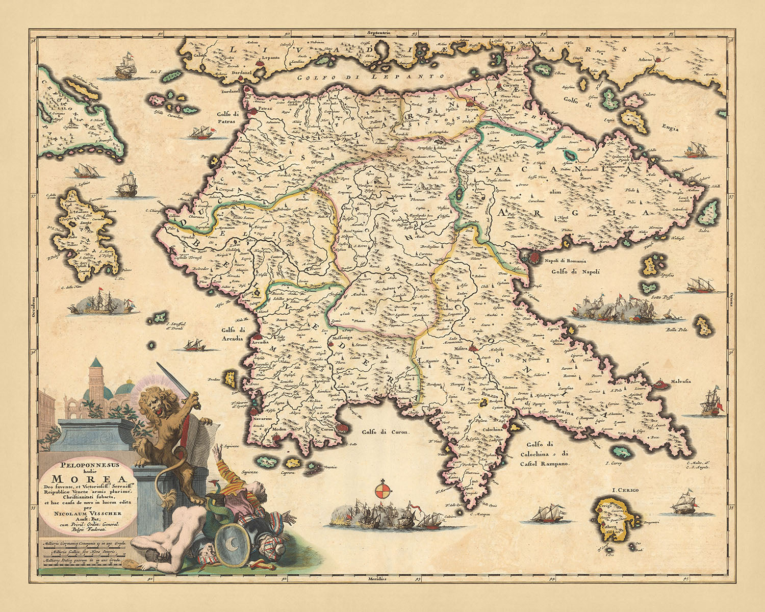


Rare Old Map of Peloponnese, Greece by Visscher, 1690: Patras, Zakinthos, Kalamata, Nafplion, Saronic Islands
20% off 2 — 33% off 3
Add any two eligible items to your bag to receive 20% off. Add a third and it will be complimentary (equivalent to 33% off when purchasing three).
No code needed — the offer applies automatically at checkout.
Valid on all standard maps and fine art prints. You can mix and match any designs.
If you’d like to ship items to multiple addresses, please contact us before placing your order.
Custom and bespoke commissions are excluded.
Contact us if you have any questions
 Designed in London Made in the UK
Designed in London • Made in the UK
Designed in London Made in the UK
Designed in London • Made in the UK

Choose your size
Framing


(More info)
Gift message & custom finish

If you want to add a gift message, or a finish (jigsaw, aluminium board, etc.) that is not available here, please request it in the "order note" when you check out.
Every order is custom made, so if you need the size adjusted slightly, or printed on an unusual material, just let us know. We've done thousands of custom orders over the years, so there's (almost) nothing we can't manage.
You can also contact us before you order, if you prefer!

- Made locally for fast, safe delivery
- Free worldwide delivery, with no import duty surprises
- 90-day returns and 5-year guarantee
- Need advice? Message us on WhatsApp
Own a piece of history
7,000+ 5 star reviews


Experience the grandeur of the 17th century with the meticulously detailed 'Peloponnesus hodie Morea' map, a masterpiece by the renowned Dutch cartographer Nicolaes Visscher II. This magnificent work of art transports you back to 1690, offering a captivating glimpse into the historical landscape of Peloponnese, known as Morea during the period. Translated into English, the title of the map reveals its focus: 'Peloponnese, today Morea', reflecting the geographical and political landscape of the time.
The map features a wealth of significant cities, towns, and landmarks that narrate the story of the region. Notable cities such as Patras, Zakinthos, Kalamata, and Nafplion are intricately represented, each brimming with historical significance. The Saronic Islands, a group of islands in Greece, located in the Saronic Gulf, are also depicted, adding a touch of maritime intrigue to the map.
Visscher's masterpiece is not just a map, but a vibrant tapestry of natural phenomena and geographical features. It beautifully illustrates the administrative boundaries, waterways, canals, and landmarks of the time. Lakes and mountains are depicted with pictorial relief, offering a three-dimensional perspective that brings the map to life. The decorative title cartouche and compass rose add to the aesthetic appeal, making this map a perfect blend of art and cartography.
The 'Peloponnesus hodie Morea' map is a treasure trove of historical, political, and geographical information. It provides a unique perspective on the world as it was known in the late 17th century. This map is more than just a piece of history; it is a testament to the skill and craftsmanship of one of the finest mapmakers from the Dutch Golden Age. Each city, landmark, and natural feature has been depicted with an incredible level of detail, making this map a must-have for history enthusiasts, map collectors, and lovers of fine art alike.
Some of the significant locations shown on this map:
Peloponnese (Morea)
- Patras: Known as the 'Gateway to the West', Patras was a bustling port city and a significant node in maritime trade routes. It was known as 'Patrae' during Roman times.
- Zakinthos: An island in the Ionian Sea, known for its vibrant culture and rich history. It was known as 'Zacynthus' in ancient times.
- Kalamata: Known for its castle and the Church of Ypapantis, it was an important Byzantine city. It was known as 'Pharae' in ancient times.
- Nafplion: Known as the first capital of the modern Greek state, it has a rich history dating back to the prehistoric era. It was known as 'Nauplia' during the Byzantine era.
- Sparta: An ancient city known for its military strength and austere lifestyle. It was a significant city-state in ancient Greece.
- Corinth: Known for the ancient Temple of Apollo and Acrocorinth, it was a significant city-state in ancient Greece.
- Argos: One of the oldest continuously inhabited cities in the world, it was a major center of Mycenaean civilization.
- Megalopolis: Known as the 'Great City', it was an important political and cultural center in ancient Arcadia.
- Tripoli: Known for its fertile plains and as a commercial center, it was known as 'Tripolitsa' during the Ottoman era.
- Pylos: Known for the Palace of Nestor, it was a significant city in the Mycenaean civilization.
- Messenia: Known for its ancient theater and the Temple of Zeus, it was a significant region in the southwestern Peloponnese.
- Laconia: Known for the Byzantine city of Mystras, it was a significant region in southeastern Peloponnese.
- Elis: Known for hosting the Olympic Games in antiquity, it was a region in the western part of the Peloponnese.
- Achaia: Known for the ancient city of Patras, it was a region in the northern part of the Peloponnese.
- Arcadia: Known for its picturesque landscapes and as the mythological home of Pan, it was a region in the central part of the Peloponnese.
Saronic Islands
- Aegina: Known for the Temple of Aphaia, it was a significant naval power in ancient Greece.
- Poros: Known for its lush vegetation and beautiful beaches, it was a popular retreat for Athenians.
- Hydra: Known for its well-preserved architecture and role in the Greek War of Independence, it was a significant maritime center.
- Salamis: Known for the Battle of Salamis, it was a significant naval power in ancient Greece.
- Spetses: Known for its significant role in the Greek War of Independence, it was a prosperous maritime and commercial center.
Notable natural phenomena and tourist attractions:
- Mount Taygetus: Known for its rich biodiversity and hiking trails, it is the highest mountain in the Peloponnese.
- Corinth Canal: An engineering marvel that connects the Gulf of Corinth with the Saronic Gulf.
- Mani Peninsula: Known for its rugged landscapes and Byzantine churches, it is a popular tourist destination.
- Neda River: Known for its beautiful waterfalls and lush vegetation, it is a popular spot for nature lovers.
- Diros Caves: Known for their stunning stalactite and stalagmite formations, they are a major tourist attraction.
Notable historical events between 1600 and 1690:
- The Morean War (1684-1699): A part of the wider conflict known as the Great Turkish War, it resulted in the recapture of the Peloponnese by the Venetians.
- The Cretan War (1645-1669): A conflict between the Ottoman Empire and the Venetian Republic, it had significant implications for the balance of power in the eastern Mediterranean.
- The Orlov Revolt (1770): A precursor to the Greek War of Independence, it was an early attempt to liberate Greece from Ottoman rule.
Please double check the images to make sure that a specific town or place is shown on this map. You can also get in touch and ask us to check the map for you.
This map looks great at all sizes: 12x16in (30.5x41cm), 16x20in (40.5x51cm), 18x24in (45.5x61cm), 24x30in (61x76cm), 32x40in (81.5x102cm), 40x50in (102x127cm), 48x60in (122x153cm) and 56x70in (142x178cm), but it looks even better when printed large.
I can create beautiful, large prints of this map up to 90in (229cm). Please get in touch if you're looking for larger, customised or different framing options.
The model in the listing images is holding the 16x20in (40.5x51cm) version of this map.
The fifth listing image shows an example of my map personalisation service.
If you’re looking for something slightly different, check out my collection of the best old maps of Europe and European cities to see if something else catches your eye.
Please contact me to check if a certain location, landmark or feature is shown on this map.
This would make a wonderful birthday, Christmas, Father's Day, work leaving, anniversary or housewarming gift for someone from the areas covered by this map.
This map is available as a giclée print on acid free archival matte paper, or you can buy it framed. The frame is a nice, simple black frame that suits most aesthetics. Please get in touch if you'd like a different frame colour or material. My frames are glazed with super-clear museum-grade acrylic (perspex/acrylite), which is significantly less reflective than glass, safer, and will always arrive in perfect condition.
This map is also available as a float framed canvas, sometimes known as a shadow gap framed canvas or canvas floater. The map is printed on artist's cotton canvas and then stretched over a handmade box frame. We then "float" the canvas inside a wooden frame, which is available in a range of colours (black, dark brown, oak, antique gold and white). This is a wonderful way to present a map without glazing in front. See some examples of float framed canvas maps and explore the differences between my different finishes.
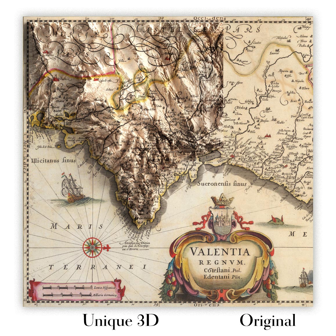
For something truly unique, this map is also available in "Unique 3D", our trademarked process that dramatically transforms the map so that it has a wonderful sense of depth. We combine the original map with detailed topography and elevation data, so that mountains and the terrain really "pop". For more info and examples of 3D maps, check my Unique 3D page.
Many of our maps and art prints are chosen as thoughtful gifts for homes, offices, studies and meaningful places.
Choose a framed option for the easiest ready-to-hang gift, or choose an unframed print if the recipient may prefer to select their own frame.
We make orders locally in 23 countries around the world, so gifts can often be produced close to the recipient. This helps them arrive faster, travel more safely, and avoid customs or import duty surprises.
- We can deliver directly to the recipient
- Framed pieces arrive ready to hang
- Unframed prints are carefully packed in a strong protective tube
- Almost every order is made locally, for faster, safer gifting
- 90-day returns give the recipient time to decide
If you are not sure what to choose, please contact us. We can help you pick the right map, size, finish or delivery option.
Most orders are made locally and delivered in around 2–3 working days, depending on the product, size and destination.
We print and frame maps and artwork in 23 countries around the world, so your order is usually made close to you or your recipient. That means faster delivery, less time in transit, and no customs or import duty surprises.
Personalised and customised pieces usually take an extra 1–2 working days, because we prepare your design and send it to you for approval before printing.
Very large framed orders can take a little longer, as they need extra care in production and delivery.
Every order is carefully packaged: unframed prints are sent in a strong protective tube, while framed pieces are securely packed with protective materials around the frame.
If you need your order by a particular date, please contact us before ordering. We’ll check the best production route and delivery option for your location.
Express delivery is available at checkout for most countries. Next-day delivery is available in the UK, US, Singapore and the UAE.
Your order is covered by our 90-day returns policy and 5-year guarantee.
My standard frame is a gallery style black ash hardwood frame. It is simple and quite modern looking. My standard frame is around 20mm (0.8in) wide.
I use super-clear acrylic (perspex/acrylite) for the frame glass. It's lighter and safer than glass - and it looks better, as the reflectivity is lower.
Six standard frame colours are available for free (black, dark brown, dark grey, oak, white and antique gold). Custom framing and mounting/matting is available if you're looking for something else.
Most maps, art and illustrations are also available as a framed canvas. We use matte (not shiny) cotton canvas, stretch it over a sustainably sourced box wood frame, and then 'float' the piece within a wood frame. The end result is quite beautiful, and there's no glazing to get in the way.
All frames are provided "ready to hang", with either a string or brackets on the back. Very large frames will have heavy duty hanging plates and/or a mounting baton. If you have any questions, please get in touch.
See some examples of my framed maps and framed canvas maps.
Alternatively, I can also supply old maps and artwork on canvas, foam board, cotton rag and other materials.
If you want to frame your map or artwork yourself, please read my size guide first.
My maps are extremely high quality reproductions of original maps.
I source original, rare maps from libraries, auction houses and private collections around the world, restore them at my London workshop, and then use specialist giclée inks and printers to create beautiful maps that look even better than the original.
My maps are printed on acid-free archival matte (not glossy) paper that feels very high quality and almost like card. In technical terms the paper weight/thickness is 10mil/200gsm. It's perfect for framing.
I print with Epson ultrachrome giclée UV fade resistant pigment inks - some of the best inks you can find.
I can also make maps on canvas, cotton rag and other exotic materials.
Learn more about The Unique Maps Co.
Map personalisation
If you're looking for the perfect anniversary or housewarming gift, I can personalise your map to make it truly unique. For example, I can add a short message, or highlight an important location, or add your family's coat of arms.
The options are almost infinite. Please see my map personalisation page for some wonderful examples of what's possible.
To order a personalised map, select "personalise your map" before adding it to your basket.
Get in touch if you're looking for more complex customisations and personalisations.
Map ageing
I have been asked hundreds of times over the years by customers if they could buy a map that looks even older.
Well, now you can, by selecting Aged before you add a map to your basket.
All the product photos you see on this page show the map in its Original form. This is what the map looks like today.
If you select Aged, I will age your map by hand, using a special and unique process developed through years of studying old maps, talking to researchers to understand the chemistry of aging paper, and of course... lots of practice!
If you're unsure, stick to the Original colour of the map. If you want something a bit darker and older looking, go for Aged.
If you are not happy with your order for any reason, contact me and I'll get it fixed ASAP, free of charge. Please see my returns and refund policy for more information.
I am very confident you will like your restored map or art print. I have been doing this since 1984. I'm a 5-star Etsy seller. I have sold tens of thousands of maps and art prints and have over 5,000 real 5-star reviews. My work has been featured in interior design magazines, on the BBC, and on the walls of dozens of 5-star hotels.
I use a unique process to restore maps and artwork that is massively time consuming and labour intensive. Hunting down the original maps and illustrations can take months. I use state of the art and eye-wateringly expensive technology to scan and restore them. As a result, I guarantee my maps and art prints are a cut above the rest. I stand by my products and will always make sure you're 100% happy with what you receive.
Almost all of my maps and art prints look amazing at large sizes (200cm, 6.5ft+) and I can frame and deliver them to you as well, via special oversized courier. Contact me to discuss your specific needs.
Or try searching for something!


