

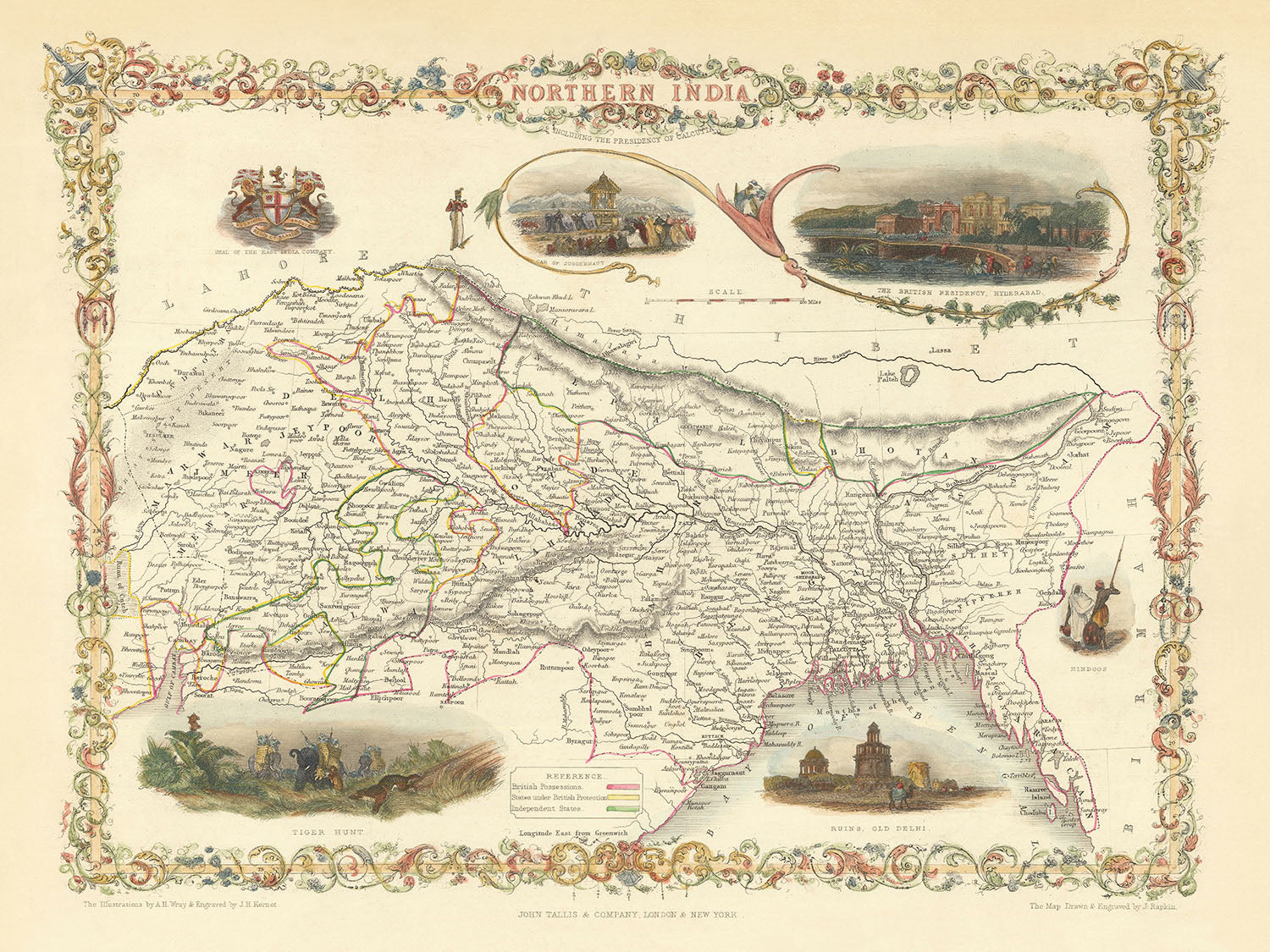


Rare Old Map of Northern India, Bangladesh, Bhutan and Nepal by Tallis & Rapkin, 1851: Delhi, Calcutta, Himalayas, Ganges
20% off 2 — 33% off 3
Add any two eligible items to your bag to receive 20% off. Add a third and it will be complimentary (equivalent to 33% off when purchasing three).
No code needed — the offer applies automatically at checkout.
Valid on all standard maps and fine art prints. You can mix and match any designs.
If you’d like to ship items to multiple addresses, please contact us before placing your order.
Custom and bespoke commissions are excluded.
Contact us if you have any questions
 Designed in London Made in the UK
Designed in London • Made in the UK
Designed in London Made in the UK
Designed in London • Made in the UK

Choose your size
Framing


(More info)
Gift message & custom finish

If you want to add a gift message, or a finish (jigsaw, aluminium board, etc.) that is not available here, please request it in the "order note" when you check out.
Every order is custom made, so if you need the size adjusted slightly, or printed on an unusual material, just let us know. We've done thousands of custom orders over the years, so there's (almost) nothing we can't manage.
You can also contact us before you order, if you prefer!

- Made locally for fast, safe delivery
- Free worldwide delivery, with no import duty surprises
- 90-day returns and 5-year guarantee
- Need advice? Message us on WhatsApp
Own a piece of history
7,000+ 5 star reviews


The "Map of Northern India" by John Tallis, engraved by J. Rapkin in 1851, is a stunning artifact from the golden age of cartography. This map, created for R. Montgomery Martin's Illustrated Atlas, offers a detailed political and physical representation of Northern India during the British Raj. The mapmaker, John Tallis, is celebrated as one of the last great decorative mapmakers, known for his exquisite artistic touch and meticulous detail. His maps are prized for their beauty and historical significance, making this piece a treasure for any collector or history enthusiast.
This map vividly illustrates the geopolitical landscape of Northern India in the mid-19th century. British-administered territories, including present-day Bangladesh and areas around Delhi, are highlighted in pink, while regions controlled by Hindu leaders are shown in yellow. The map also delineates other important states in green, with areas outside the region, such as Tibet and Burma, left uncolored and minimally detailed. The borders with Tibet are loosely defined, reflecting the fluid political boundaries of the time. Notably, Sikkim is not attributed to any nation, indicating its ambiguous status during this period.
The map is adorned with intricate vignettes that provide a glimpse into life during the Company Raj. These include the British Residency in Hyderabad, the ruins of Old Delhi, and the coat of arms of the British East India Company. These illustrations juxtapose colonial and traditional power, offering a rich visual narrative of the era. The inclusion of a tiger hunt scene adds an element of adventure and exoticism, further enhancing the map's appeal.
Geographically, the map covers a vast area encompassing present-day northeastern India, Bangladesh, Bhutan, and Nepal. Major rivers such as the Ganges and Brahmaputra are prominently featured, reflecting their importance in the region's geography and culture. The Himalayan mountain range is also depicted, emphasizing the natural barriers and the majestic landscape of the area. The map's detailed representation of rivers, cities, and geopolitical boundaries provides valuable insights into the region's historical and physical context.
The map includes numerous cities and towns, such as Delhi, Calcutta, Lucknow, Agra, and Kathmandu, each with its own historical and cultural significance. These settlements are meticulously labeled, offering a snapshot of the urban landscape during the British Raj. The map's decorative border and artistic engravings make it not only a valuable historical document but also a beautiful piece of art. Collectors and enthusiasts will appreciate the map's ability to transport them back in time, providing a window into the complex and fascinating history of Northern India.
Cities and towns on this map
- India:
- Delhi
- Calcutta (Kolkata)
- Lucknow
- Agra
- Kanpur (Cawnpore)
- Varanasi (Benares)
- Allahabad
- Patna
- Gaya
- Meerut
- Jhansi
- Gwalior
- Jaipur
- Ajmer
- Bikaner
- Jodhpur
- Udaipur
- Bareilly
- Aligarh
- Mathura
- Fatehpur
- Saharanpur
- Gorakhpur
- Murshidabad
- Burdwan
- Dacca (Dhaka)
- Chittagong
-
Sylhet
-
Nepal:
-
Kathmandu
-
Bangladesh:
- Dhaka
- Chittagong
-
Sylhet
-
Bhutan:
- Thimphu
Notable Features & Landmarks
- Illustrations:
- The British Residency in Hyderabad
- Ruins of Old Delhi
- Coat of arms of the British East India Company
-
Tiger hunt scene
-
Bodies of water:
-
Major rivers such as the Ganges and Brahmaputra
-
Borders:
- British-administered territories (pink)
- Hindu leader-controlled areas (yellow)
- Other important states (green)
-
Loosely defined borders with Tibet
-
Mountains:
-
Himalayan mountain range
-
Other notable features:
- Vignettes of indigenous scenes and people
- Decorative border around the map
Historical and design context
- Name of the map: Map of Northern India
- Mapmaker/Publisher: John Tallis & Company, engraved by J. Rapkin
- Tallis was one of the last great decorative mapmakers, known for the artistic quality of his maps.
- When the map was made: 1851
- Topics and themes:
- Political boundaries and control during the British Raj.
- Physical geography including rivers and mountain ranges.
- Cultural and historical vignettes showcasing colonial and traditional power.
- Countries and regions shown:
- Present-day northeastern India, Bangladesh, Bhutan, and Nepal.
- Areas around Delhi, Calcutta, and Fort William.
- Design/style:
- Decorative map with full-color illustrations and vignettes.
- Artistic borders and detailed engravings.
- Historical significance:
- Provides insight into the geopolitical landscape of Northern India during the mid-19th century.
- Reflects British colonial influence and administrative divisions during the Company Raj.
Please double check the images to make sure that a specific town or place is shown on this map. You can also get in touch and ask us to check the map for you.
This map looks great at every size, but I always recommend going for a larger size if you have space. That way you can easily make out all of the details.
This map looks amazing at sizes all the way up to 50in (125cm). If you are looking for a larger map, please get in touch.
The model in the listing images is holding the 18x24in (45x60cm) version of this map.
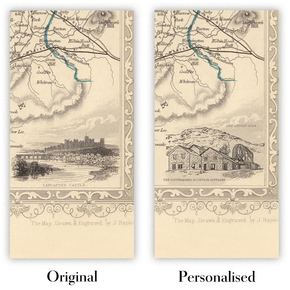
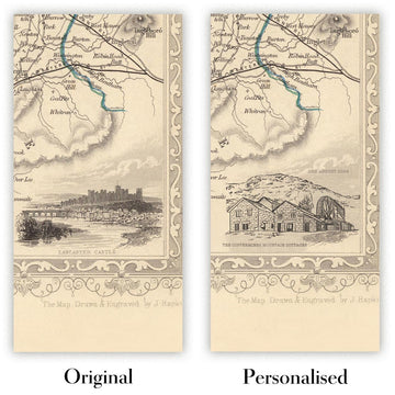
The fifth listing image shows an example of my map personalisation service.
If you’re looking for something slightly different, check out my collection of the best old maps to see if something else catches your eye.
Please contact me to check if a certain location, landmark or feature is shown on this map.
This would make a wonderful birthday, Christmas, Father's Day, work leaving, anniversary or housewarming gift for someone from the areas covered by this map.
This map is available as a giclée print on acid free archival matte paper, or you can buy it framed. The frame is a nice, simple black frame that suits most aesthetics. Please get in touch if you'd like a different frame colour or material. My frames are glazed with super-clear museum-grade acrylic (perspex/acrylite), which is significantly less reflective than glass, safer, and will always arrive in perfect condition.
This map is also available as a float framed canvas, sometimes known as a shadow gap framed canvas or canvas floater. The map is printed on artist's cotton canvas and then stretched over a handmade box frame. We then "float" the canvas inside a wooden frame, which is available in a range of colours (black, dark brown, oak, antique gold and white). This is a wonderful way to present a map without glazing in front. See some examples of float framed canvas maps and explore the differences between my different finishes.
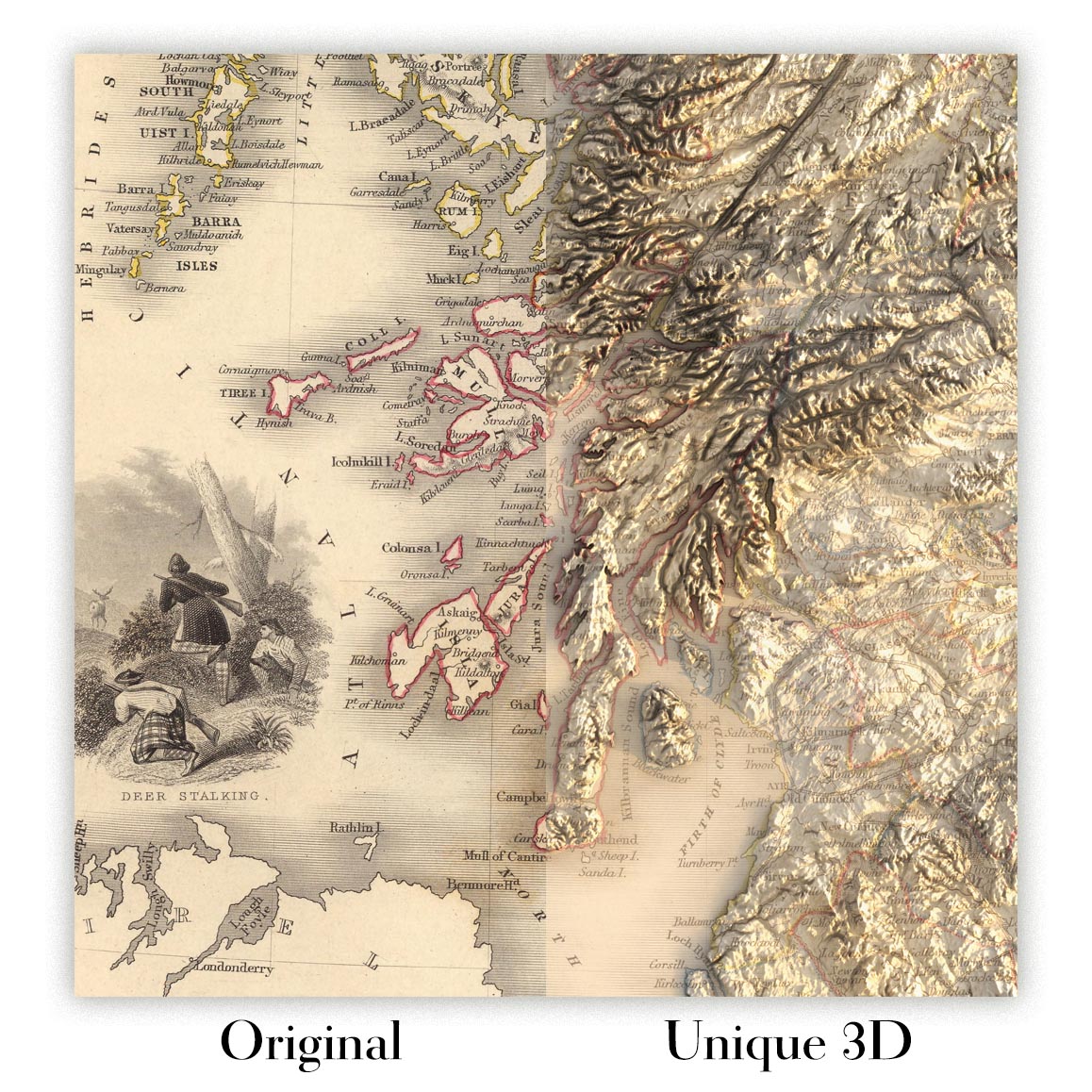
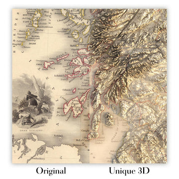
For something truly unique, this map is also available in "Unique 3D", our trademarked process that dramatically transforms the map so that it has a wonderful sense of depth. We combine the original map with detailed topography and elevation data, so that mountains and the terrain really "pop". For more info and examples of 3D maps, check my Unique 3D page.
Many of our maps and art prints are chosen as thoughtful gifts for homes, offices, studies and meaningful places.
Choose a framed option for the easiest ready-to-hang gift, or choose an unframed print if the recipient may prefer to select their own frame.
We make orders locally in 23 countries around the world, so gifts can often be produced close to the recipient. This helps them arrive faster, travel more safely, and avoid customs or import duty surprises.
- We can deliver directly to the recipient
- Framed pieces arrive ready to hang
- Unframed prints are carefully packed in a strong protective tube
- Almost every order is made locally, for faster, safer gifting
- 90-day returns give the recipient time to decide
If you are not sure what to choose, please contact us. We can help you pick the right map, size, finish or delivery option.
Most orders are made locally and delivered in around 2–3 working days, depending on the product, size and destination.
We print and frame maps and artwork in 23 countries around the world, so your order is usually made close to you or your recipient. That means faster delivery, less time in transit, and no customs or import duty surprises.
Personalised and customised pieces usually take an extra 1–2 working days, because we prepare your design and send it to you for approval before printing.
Very large framed orders can take a little longer, as they need extra care in production and delivery.
Every order is carefully packaged: unframed prints are sent in a strong protective tube, while framed pieces are securely packed with protective materials around the frame.
If you need your order by a particular date, please contact us before ordering. We’ll check the best production route and delivery option for your location.
Express delivery is available at checkout for most countries. Next-day delivery is available in the UK, US, Singapore and the UAE.
Your order is covered by our 90-day returns policy and 5-year guarantee.
My standard frame is a gallery style black ash hardwood frame. It is simple and quite modern looking. My standard frame is around 20mm (0.8in) wide.
I use super-clear acrylic (perspex/acrylite) for the frame glass. It's lighter and safer than glass - and it looks better, as the reflectivity is lower.
Six standard frame colours are available for free (black, dark brown, dark grey, oak, white and antique gold). Custom framing and mounting/matting is available if you're looking for something else.
Most maps, art and illustrations are also available as a framed canvas. We use matte (not shiny) cotton canvas, stretch it over a sustainably sourced box wood frame, and then 'float' the piece within a wood frame. The end result is quite beautiful, and there's no glazing to get in the way.
All frames are provided "ready to hang", with either a string or brackets on the back. Very large frames will have heavy duty hanging plates and/or a mounting baton. If you have any questions, please get in touch.
See some examples of my framed maps and framed canvas maps.
Alternatively, I can also supply old maps and artwork on canvas, foam board, cotton rag and other materials.
If you want to frame your map or artwork yourself, please read my size guide first.
My maps are extremely high quality reproductions of original maps.
I source original, rare maps from libraries, auction houses and private collections around the world, restore them at my London workshop, and then use specialist giclée inks and printers to create beautiful maps that look even better than the original.
My maps are printed on acid-free archival matte (not glossy) paper that feels very high quality and almost like card. In technical terms the paper weight/thickness is 10mil/200gsm. It's perfect for framing.
I print with Epson ultrachrome giclée UV fade resistant pigment inks - some of the best inks you can find.
I can also make maps on canvas, cotton rag and other exotic materials.
Learn more about The Unique Maps Co.
Map personalisation
If you're looking for the perfect anniversary or housewarming gift, I can personalise your map to make it truly unique. For example, I can add a short message, or highlight an important location, or add your family's coat of arms.
The options are almost infinite. Please see my map personalisation page for some wonderful examples of what's possible.
To order a personalised map, select "personalise your map" before adding it to your basket.
Get in touch if you're looking for more complex customisations and personalisations.
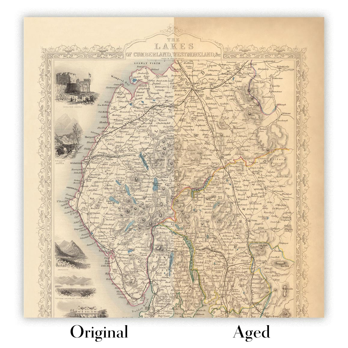
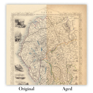
Map ageing
I have been asked hundreds of times over the years by customers if they could buy a map that looks even older.
Well, now you can, by selecting Aged before you add a map to your basket.
All the product photos you see on this page show the map in its Original form. This is what the map looks like today.
If you select Aged, I will age your map by hand, using a special and unique process developed through years of studying old maps, talking to researchers to understand the chemistry of aging paper, and of course... lots of practice!
If you're unsure, stick to the Original colour of the map. If you want something a bit darker and older looking, go for Aged.
If you are not happy with your order for any reason, contact me and I'll get it fixed ASAP, free of charge. Please see my returns and refund policy for more information.
I am very confident you will like your restored map or art print. I have been doing this since 1984. I'm a 5-star Etsy seller. I have sold tens of thousands of maps and art prints and have over 5,000 real 5-star reviews. My work has been featured in interior design magazines, on the BBC, and on the walls of dozens of 5-star hotels.
I use a unique process to restore maps and artwork that is massively time consuming and labour intensive. Hunting down the original maps and illustrations can take months. I use state of the art and eye-wateringly expensive technology to scan and restore them. As a result, I guarantee my maps and art prints are a cut above the rest. I stand by my products and will always make sure you're 100% happy with what you receive.
Almost all of my maps and art prints look amazing at large sizes (200cm, 6.5ft+) and I can frame and deliver them to you as well, via special oversized courier. Contact me to discuss your specific needs.
Or try searching for something!


