

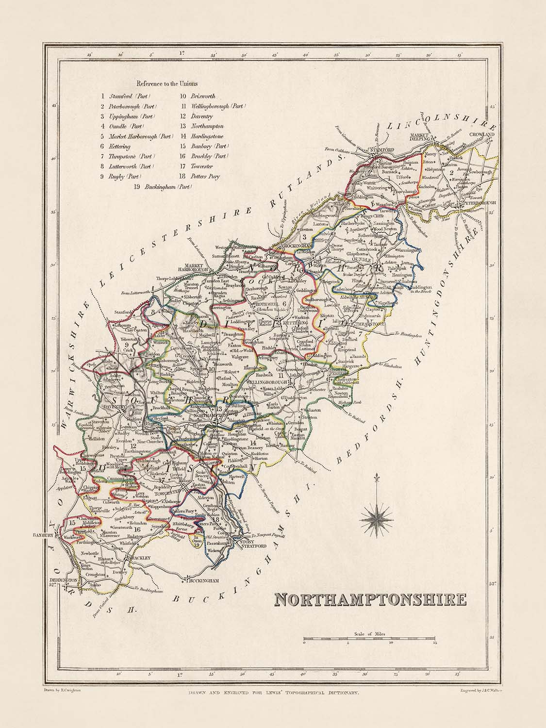


Rare Old Map of Northamptonshire by Samuel Lewis, 1844: Northampton, Kettering, Corby, Wellingborough, and Rushden
20% off 2 — 33% off 3
Add any two eligible items to your bag to receive 20% off. Add a third and it will be complimentary (equivalent to 33% off when purchasing three).
No code needed — the offer applies automatically at checkout.
Valid on all standard maps and fine art prints. You can mix and match any designs.
If you’d like to ship items to multiple addresses, please contact us before placing your order.
Custom and bespoke commissions are excluded.
Contact us if you have any questions
 Designed in London Made in the UK
Designed in London • Made in the UK
Designed in London Made in the UK
Designed in London • Made in the UK

Choose your size
Framing


(More info)
Gift message & custom finish

If you want to add a gift message, or a finish (jigsaw, aluminium board, etc.) that is not available here, please request it in the "order note" when you check out.
Every order is custom made, so if you need the size adjusted slightly, or printed on an unusual material, just let us know. We've done thousands of custom orders over the years, so there's (almost) nothing we can't manage.
You can also contact us before you order, if you prefer!

- Made locally for fast, safe delivery
- Free worldwide delivery, with no import duty surprises
- 90-day returns and 5-year guarantee
- Need advice? Message us on WhatsApp
Own a piece of history
7,000+ 5 star reviews


Discover the rich history of Northamptonshire brought to life with this 1844 map by renowned cartographer, Samuel Lewis. Beautifully drawn, it offers a unique glimpse into the past of one of England's most enduring regions. Highlighting a rich array of towns, cities, and settlements, the map is an intricate tapestry of Northamptonshire's history and heritage, showcasing where many of today's bustling towns and cities first began. Delight in the historical place names that mark locations familiar today; yet, be prepared to not find some modern cities, or excitingly, discover them labelled under their former names.
A perfect addition to any cartophile's collection, this map also serves as an educational tool for those keen on English history. Samuel Lewis’s 1844 map is a testament to the remarkable development and transformation of Northamptonshire from the mid-19th century to present times. Rich in detail, it reflects the geography of the era, offering a fascinating insight into the region's past, the old roadways and waterways, and the significant historical events that occurred within its boundaries.
Bulleted List of Towns, Cities, and Settlements (Ordered by Modern-Day Population):
- Northampton (Founded in 914 AD) - Known as Hamtun in the Domesday Book, Northampton was an important royal borough and trade centre in the Middle Ages.
- Kettering (10th Century AD) - Originally an Anglo-Saxon settlement, Kettering flourished as a result of the booming shoe industry in the 18th and 19th centuries.
- Corby (8th Century AD) - Corby's heritage can be traced back to the Vikings. It was a small village until the 19th-century ironstone industry led to rapid expansion.
- Wellingborough (6th Century AD) - Wellingborough is renowned for its five medieval wells and was an important market town noted for its wool and cloth trade.
- Rushden (9th Century AD) - Inhabited since the Saxon era, Rushden became an important hub for the boot and shoe industry in the 19th century.
- Daventry (Medieval Period) - An ancient market town, Daventry held royal charters granting it status and significance in the county.
- Brackley (1086 AD) - Known for its lace and wool industries, Brackley was originally mentioned in the Domesday Book.
- Desborough (Prehistoric Times) - Dating back to the Bronze Age, Desborough was primarily an agricultural community until the 19th century.
- Towcester (1st Century AD) - A Roman town established on Watling Street, it's one of the oldest continuous settlements in England.
- Raunds (Medieval Period) - A historical settlement known for its leather and footwear industry.
- Rothwell (Saxon Period) - Rothwell, named after the Red Well, was an important center for cloth trade.
- Oundle (1st Century AD) - A market town dating back to Roman times, known for its Georgian streetscapes.
- Burton Latimer (Saxon Era) - Known for its ironstone quarrying, the town prospered during the Industrial Revolution.
- Thrapston (Anglo-Saxon Era) - The town's annual fair and market were mentioned in medieval documents.
- Irthlingborough (6th Century AD) - Known for its historic ironworks, the town was the smallest borough in England by the time of the 1832 Reform Act.
- Higham Ferrers (Pre-Norman Conquest) - Granted a market charter in 1201, it was a royal manor in Saxon times.
- Earls Barton (Anglo-Saxon Era) - Famous for one of the finest Anglo-Saxon churches in England, the All Saints' Church.
- Finedon (Iron Age) - Finedon's St Mary's Church is a notable landmark with its 14th-century tower.
- Kings Sutton (Roman Era) - The village has several well-preserved 17th-century houses.
- Moulton (Saxon Era) - Known for its shoe industry, the village has several historic buildings.
- Silverstone (Roman Era) - The village is now synonymous with its internationally renowned racing circuit.
- Potterspury (Iron Age) - The ancient Watling Street runs through this village, with Iron Age and Roman occupation evidence.
- Brixworth (6th Century AD) - Known for its Anglo-Saxon church, one of the oldest and most complete in the country.
- Cogenhoe (Domesday Book 1086 AD) - The village's name derives from the Old English for "Cuckoo Hill."
- Blisworth (Anglo-Saxon Era) - Known for the Blisworth Tunnel, a marvel of 19th-century engineering.
- Warmington (Roman Era) - It boasts an impressive collection of ironstone cottages and the 13th-century Church of St. Mary.
- Geddington (Medieval Period) - Known for its well-preserved Eleanor Cross, one of the best in England.
- Crick (Roman Era) - Noted for its canal history and the Crick Boat Show, the largest inland waterways event in Britain.
- Paulerspury (Domesday Book 1086 AD) - An old village with many historic buildings, including St James the Great church.
- Bugbrooke (Roman Era) - The site of a large Roman villa, indicating the village's long history.
Notable Features:
- River Nene - The largest river in the county, providing beautiful landscapes and significant wildlife habitats.
- Grand Union Canal - A central waterway during the Industrial Revolution, now popular for boating and walks.
- Rockingham Forest - Once a royal hunting forest, it is now a mixture of ancient woodland and farmland.
Historical Events (1800-1850):
- The Swing Riots (1830) - Agricultural labourers in the county participated in this widespread protest against agricultural mechanisation.
- Opening of the Blisworth Tunnel (1805) - Part of the Grand Union Canal, it greatly improved transport and trade in the region.
- Corby's Ironstone Boom (1850) - The demand for ironstone led to rapid development and population growth in Corby.
Please double check the images to make sure that a specific town or place is shown on this map. You can also get in touch and ask us to check the map for you.
This map looks great at all sizes: 8x10in (20.5x25.5cm), 12x16in (30.5x41cm), 18x24in (45.5x61cm), 16x20in (40.5x51cm), 24x36in (61x91.5cm), 30x40in (76x101.5cm) and 37x50in (94x127cm), but it looks even better when printed large.
I can create beautiful, large prints of this map up to 50in (127cm). Please get in touch if you're looking for larger, customised or different framing options.
The model in the listing images is holding the 18x24in (45.5x61cm) version of this map.
The fifth listing image shows an example of my map personalisation service.
If you’re looking for something slightly different, check out my main collection of UK and Ireland maps.
Please contact me to check if a certain location, landmark or feature is shown on this map.
This would make a wonderful birthday, Christmas, Father's Day, work leaving, anniversary or housewarming gift for someone from the areas covered by this map.
This map is available as a giclée print on acid free archival matte paper, or you can buy it framed. The frame is a nice, simple black frame that suits most aesthetics. Please get in touch if you'd like a different frame colour or material. My frames are glazed with super-clear museum-grade acrylic (perspex/acrylite), which is significantly less reflective than glass, safer, and will always arrive in perfect condition.
This map is also available as a float framed canvas, sometimes known as a shadow gap framed canvas or canvas floater. The map is printed on artist's cotton canvas and then stretched over a handmade box frame. We then "float" the canvas inside a wooden frame, which is available in a range of colours (black, dark brown, oak, antique gold and white). This is a wonderful way to present a map without glazing in front. See some examples of float framed canvas maps and explore the differences between my different finishes.
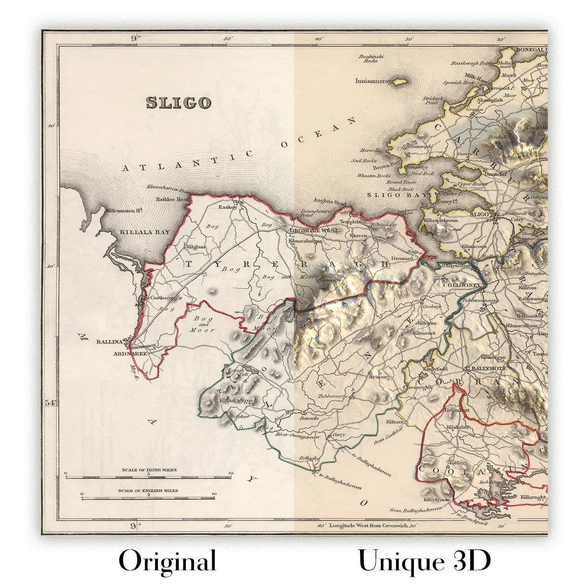
For something truly unique, this map is also available in "Unique 3D", our trademarked process that dramatically transforms the map so that it has a wonderful sense of depth. We combine the original map with detailed topography and elevation data, so that mountains and the terrain really "pop". For more info and examples of 3D maps, check my Unique 3D page.
Many of our maps and art prints are chosen as thoughtful gifts for homes, offices, studies and meaningful places.
Choose a framed option for the easiest ready-to-hang gift, or choose an unframed print if the recipient may prefer to select their own frame.
We make orders locally in 23 countries around the world, so gifts can often be produced close to the recipient. This helps them arrive faster, travel more safely, and avoid customs or import duty surprises.
- We can deliver directly to the recipient
- Framed pieces arrive ready to hang
- Unframed prints are carefully packed in a strong protective tube
- Almost every order is made locally, for faster, safer gifting
- 90-day returns give the recipient time to decide
If you are not sure what to choose, please contact us. We can help you pick the right map, size, finish or delivery option.
Most orders are made locally and delivered in around 2–3 working days, depending on the product, size and destination.
We print and frame maps and artwork in 23 countries around the world, so your order is usually made close to you or your recipient. That means faster delivery, less time in transit, and no customs or import duty surprises.
Personalised and customised pieces usually take an extra 1–2 working days, because we prepare your design and send it to you for approval before printing.
Very large framed orders can take a little longer, as they need extra care in production and delivery.
Every order is carefully packaged: unframed prints are sent in a strong protective tube, while framed pieces are securely packed with protective materials around the frame.
If you need your order by a particular date, please contact us before ordering. We’ll check the best production route and delivery option for your location.
Express delivery is available at checkout for most countries. Next-day delivery is available in the UK, US, Singapore and the UAE.
Your order is covered by our 90-day returns policy and 5-year guarantee.
My standard frame is a gallery style black ash hardwood frame. It is simple and quite modern looking. My standard frame is around 20mm (0.8in) wide.
I use super-clear acrylic (perspex/acrylite) for the frame glass. It's lighter and safer than glass - and it looks better, as the reflectivity is lower.
Six standard frame colours are available for free (black, dark brown, dark grey, oak, white and antique gold). Custom framing and mounting/matting is available if you're looking for something else.
Most maps, art and illustrations are also available as a framed canvas. We use matte (not shiny) cotton canvas, stretch it over a sustainably sourced box wood frame, and then 'float' the piece within a wood frame. The end result is quite beautiful, and there's no glazing to get in the way.
All frames are provided "ready to hang", with either a string or brackets on the back. Very large frames will have heavy duty hanging plates and/or a mounting baton. If you have any questions, please get in touch.
See some examples of my framed maps and framed canvas maps.
Alternatively, I can also supply old maps and artwork on canvas, foam board, cotton rag and other materials.
If you want to frame your map or artwork yourself, please read my size guide first.
My maps are extremely high quality reproductions of original maps.
I source original, rare maps from libraries, auction houses and private collections around the world, restore them at my London workshop, and then use specialist giclée inks and printers to create beautiful maps that look even better than the original.
My maps are printed on acid-free archival matte (not glossy) paper that feels very high quality and almost like card. In technical terms the paper weight/thickness is 10mil/200gsm. It's perfect for framing.
I print with Epson ultrachrome giclée UV fade resistant pigment inks - some of the best inks you can find.
I can also make maps on canvas, cotton rag and other exotic materials.
Learn more about The Unique Maps Co.
Map personalisation
If you're looking for the perfect anniversary or housewarming gift, I can personalise your map to make it truly unique. For example, I can add a short message, or highlight an important location, or add your family's coat of arms.
The options are almost infinite. Please see my map personalisation page for some wonderful examples of what's possible.
To order a personalised map, select "personalise your map" before adding it to your basket.
Get in touch if you're looking for more complex customisations and personalisations.
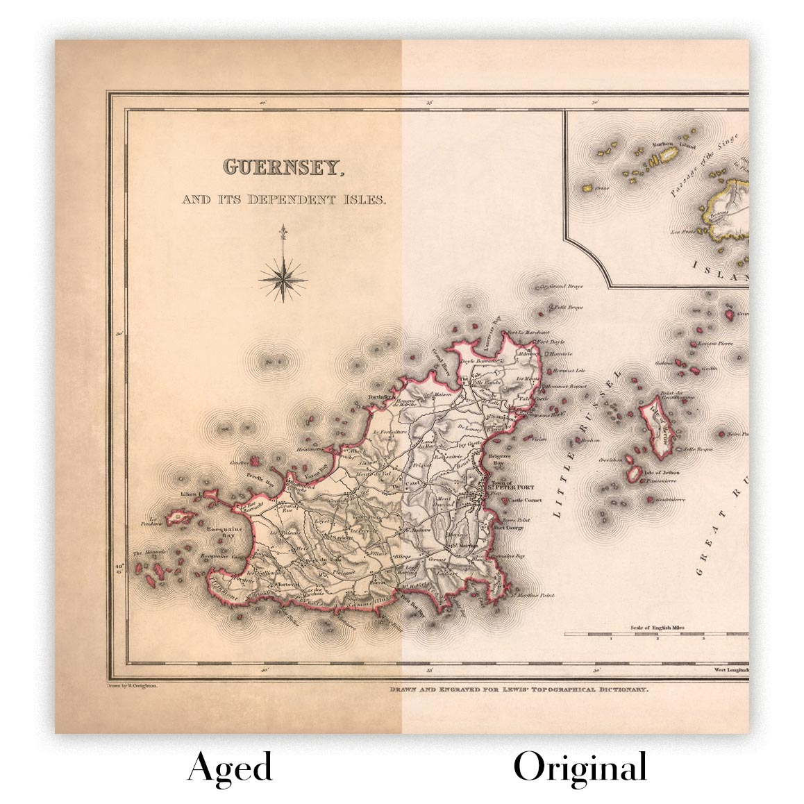
Map ageing
I have been asked hundreds of times over the years by customers if they could buy a map that looks even older.
Well, now you can, by selecting Aged before you add a map to your basket.
All the product photos you see on this page show the map in its Original form. This is what the map looks like today.
If you select Aged, I will age your map by hand, using a special and unique process developed through years of studying old maps, talking to researchers to understand the chemistry of aging paper, and of course... lots of practice!
If you're unsure, stick to the Original colour of the map. If you want something a bit darker and older looking, go for Aged.
If you are not happy with your order for any reason, contact me and I'll get it fixed ASAP, free of charge. Please see my returns and refund policy for more information.
I am very confident you will like your restored map or art print. I have been doing this since 1984. I'm a 5-star Etsy seller. I have sold tens of thousands of maps and art prints and have over 5,000 real 5-star reviews. My work has been featured in interior design magazines, on the BBC, and on the walls of dozens of 5-star hotels.
I use a unique process to restore maps and artwork that is massively time consuming and labour intensive. Hunting down the original maps and illustrations can take months. I use state of the art and eye-wateringly expensive technology to scan and restore them. As a result, I guarantee my maps and art prints are a cut above the rest. I stand by my products and will always make sure you're 100% happy with what you receive.
Almost all of my maps and art prints look amazing at large sizes (200cm, 6.5ft+) and I can frame and deliver them to you as well, via special oversized courier. Contact me to discuss your specific needs.
Or try searching for something!


