


Rare Old Map of Longest Rivers in the World by Smith, 1817: Comparative Lengths, Missouri, Nile, Amazon, etc.
20% off 2 — 33% off 3
Add any two eligible items to your bag to receive 20% off. Add a third and it will be complimentary (equivalent to 33% off when purchasing three).
No code needed — the offer applies automatically at checkout.
Valid on all standard maps and fine art prints. You can mix and match any designs.
If you’d like to ship items to multiple addresses, please contact us before placing your order.
Custom and bespoke commissions are excluded.
Contact us if you have any questions
 Designed in London Made in the UK
Designed in London • Made in the UK
Designed in London Made in the UK
Designed in London • Made in the UK

Restored from the original 1817 map and printed to museum-grade archival standards. Read the full description below.
Choose your size
Choose your finish


(More info)
Gift message & custom finish

If you want to add a gift message, or a finish (jigsaw, aluminium board, etc.) that is not available here, please request it in the "order note" when you check out.
Every order is custom made, so if you need the size adjusted slightly, or printed on an unusual material, just let us know. We've done thousands of custom orders over the years, so there's (almost) nothing we can't manage.
You can also contact us before you order, if you prefer!

- Made locally for fast, safe delivery
- No import duty or hidden fees
- Need advice? Call us or message on WhatsApp
Own a piece of history
8,000+ five-star reviews


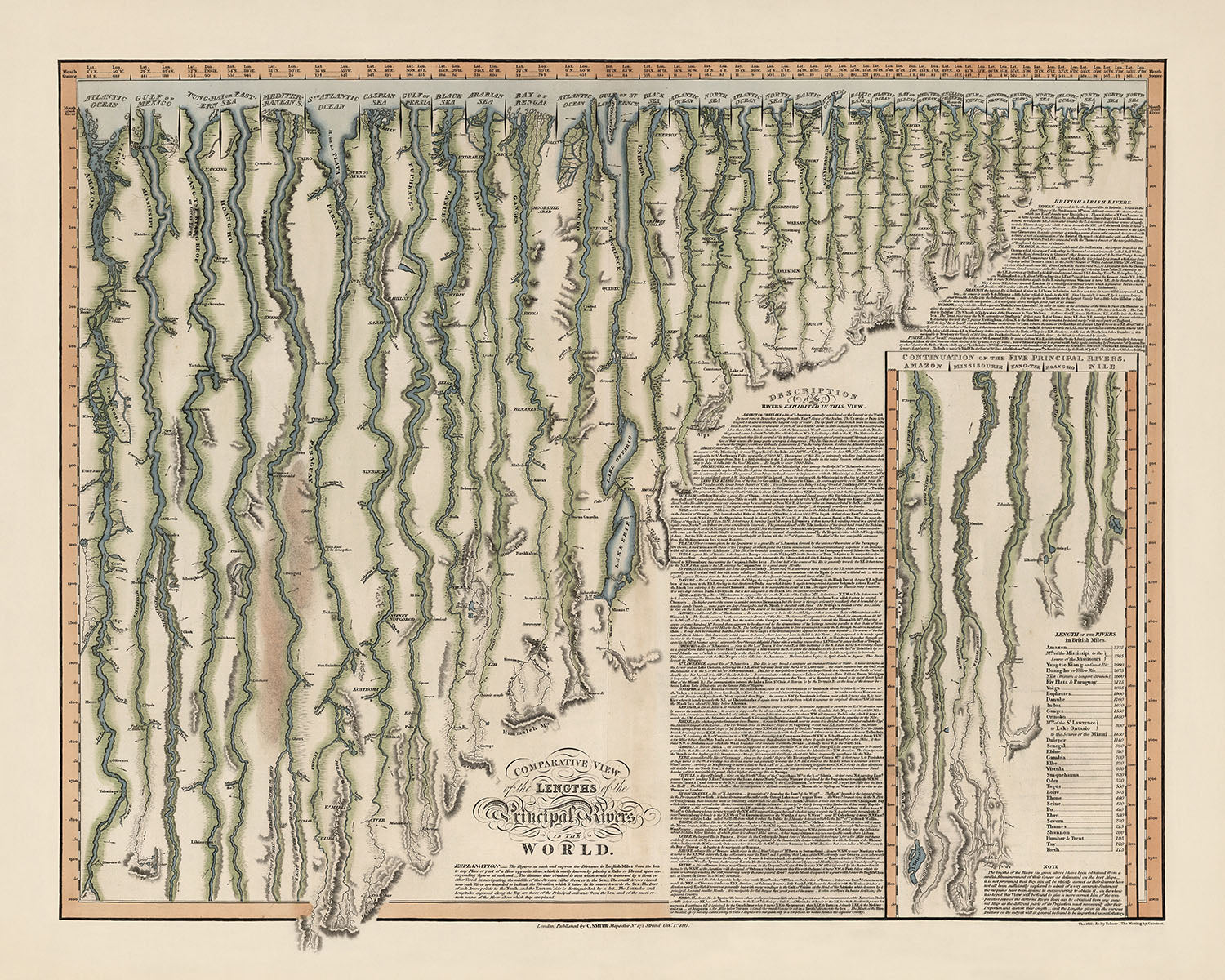
Step into the world of early 19th-century geographical exploration with this exquisite "Comparative View of the Lengths of the Principal Rivers in...
Read the full product descriptionStep into the world of early 19th-century geographical exploration with this exquisite "Comparative View of the Lengths of the Principal Rivers in the World," crafted by the renowned mapmaker C. Smith in 1817. This beautifully colored thematic map offers a fascinating comparative analysis of the world's major rivers, meticulously straightened to showcase their lengths. The map's unique design and detailed illustrations provide an insightful glimpse into the geographical knowledge and exploration achievements of the time, making it a captivating piece for any map enthusiast or history aficionado.
The map features a comprehensive table listing the lengths of the rivers in British miles, accompanied by textual descriptions that offer deeper insights into each river's course and significance. Notably, the Missouri River is highlighted with a detailed account of its exploration by Lewis and Clark, emphasizing its "extremely devious" path. This historical context not only adds depth to the map but also underscores the importance of river navigation and exploration during this period.
One of the most striking elements of this map is its use of color and design to enhance the visual appeal and clarity of the information presented. The rivers are color-coded and straightened, with small north-pointing arrows indicating the direction of flow. This innovative approach allows for easy comparison of river lengths and provides a clear and engaging visual representation of the data. The map's elegant design and attention to detail make it a true work of art.
C. Smith, the mapmaker, was a prominent figure in early 19th-century cartography, known for his detailed and informative maps. His work reflects a deep understanding of geography and a commitment to accuracy and clarity. This map is a testament to his skill and dedication, offering a unique perspective on the world's principal rivers and their significance in global geography.
This map is not just a geographical tool but a historical document that captures the spirit of exploration and discovery that defined the early 19th century. It provides a comparative understanding of river lengths across different continents, including North America, South America, Africa, Europe, and Asia. The map's educational value and historical significance make it a valuable addition to any collection, offering a window into the past and a deeper appreciation of the natural world.
Places on this map
- Missouri River
- Amazon River
- Nile River
- Mississippi River
- Yangtze River
- Danube River
- Ganges River
- Volga River
- Rhine River
- Thames River
- Orinoco River
- Euphrates River
- Indus River
- Niger River
- Don River
- Tigris River
- Dnieper River
- Loire River
- Elbe River
- Seine River
- Tagus River
- Vistula River
- Po River
- Weser River
- Guadiana River
- Ebro River
- Rhone River
- Dniester River
- Douro River
Notable Features & Landmarks
- Comparative lengths of the world's principal rivers.
- Direction of river flow indicated by small north-pointing arrows.
- Lengths of rivers in British miles.
- Detailed textual descriptions accompanying the illustration.
- Mention of the Missouri River's exploration by Lewis and Clark.
- Rivers from various continents including North America, South America, Africa, Europe, and Asia.
- Straightened rivers for comparative purposes.
- Color-coded rivers to enhance visual appeal.
- Comprehensive table listing the lengths of the rivers.
- Early 19th-century understanding of world geography.
- Educational value in providing a comparative understanding of river lengths.
- Insight into the geographical knowledge and exploration achievements of the early 1800s.
Historical and design context
- Created by C. Smith in 1817, a notable mapmaker of the early 19th century.
- Reflects early 19th-century geographical knowledge and exploration.
- Highlights the importance of river navigation and exploration during this period.
- Infographic thematic map showcasing comparative analysis.
- Rivers are straightened to indicate their lengths.
- Use of color and design to enhance visual appeal and clarity.
- Compass orientation of the flowing stream indicated by small north-pointing arrows.
- Detailed textual descriptions provide deeper insights into each river's course and significance.
- Historical context of the Missouri River's exploration by Lewis and Clark.
- Offers a unique perspective on the world's principal rivers and their significance in global geography.
- Provides a window into the past and a deeper appreciation of the natural world.
Please double check the images to make sure that a specific town or place is shown on this map. You can also get in touch and ask us to check the map for you.
This map looks great at every size, but I always recommend going for a larger size if you have space. That way you can easily make out all of the details.
This map looks amazing at sizes all the way up to 70in (180cm). If you are looking for a larger map, please get in touch.
Please note: the labels on this map are hard to read if you order a map that is 20in (50cm) or smaller. The map is still very attractive, but if you would like to read the map easily, please buy a larger size.
The model in the listing images is holding the 16x20in (40x50cm) version of this map.
The fifth listing image shows an example of my map personalisation service.
If you’re looking for something slightly different, check out my collection of the best old maps to see if something else catches your eye.
Please contact me to check if a certain location, landmark or feature is shown on this map.
This would make a wonderful birthday, Christmas, Father's Day, work leaving, anniversary or housewarming gift for someone from the areas covered by this map.
This map is available as a giclée print on acid free archival matte paper, or you can buy it framed. The frame is a nice, simple black frame that suits most aesthetics. Please get in touch if you'd like a different frame colour or material. My frames are glazed with super-clear museum-grade acrylic (perspex/acrylite), which is significantly less reflective than glass, safer, and will always arrive in perfect condition.
This map is also available as a float framed canvas, sometimes known as a shadow gap framed canvas or canvas floater. The map is printed on artist's cotton canvas and then stretched over a handmade box frame. We then "float" the canvas inside a wooden frame, which is available in a range of colours (black, dark brown, oak, antique gold and white). This is a wonderful way to present a map without glazing in front. See some examples of float framed canvas maps and explore the differences between my different finishes.
For something truly unique, this map is also available in "Unique 3D", our trademarked process that dramatically transforms the map so that it has a wonderful sense of depth. We combine the original map with detailed topography and elevation data, so that mountains and the terrain really "pop". For more info and examples of 3D maps, check my Unique 3D page.
Step into the world of early 19th-century geographical exploration with this exquisite "Comparative View of the Lengths of the Principal Rivers in the World," crafted by the renowned mapmaker C. Smith in 1817. This beautifully colored thematic map offers a fascinating comparative analysis of the world's major rivers, meticulously straightened to showcase their lengths. The map's unique design and detailed illustrations provide an insightful glimpse into the geographical knowledge and exploration achievements of the time, making it a captivating piece for any map enthusiast or history aficionado.
The map features a comprehensive table listing the lengths of the rivers in British miles, accompanied by textual descriptions that offer deeper insights into each river's course and significance. Notably, the Missouri River is highlighted with a detailed account of its exploration by Lewis and Clark, emphasizing its "extremely devious" path. This historical context not only adds depth to the map but also underscores the importance of river navigation and exploration during this period.
One of the most striking elements of this map is its use of color and design to enhance the visual appeal and clarity of the information presented. The rivers are color-coded and straightened, with small north-pointing arrows indicating the direction of flow. This innovative approach allows for easy comparison of river lengths and provides a clear and engaging visual representation of the data. The map's elegant design and attention to detail make it a true work of art.
C. Smith, the mapmaker, was a prominent figure in early 19th-century cartography, known for his detailed and informative maps. His work reflects a deep understanding of geography and a commitment to accuracy and clarity. This map is a testament to his skill and dedication, offering a unique perspective on the world's principal rivers and their significance in global geography.
This map is not just a geographical tool but a historical document that captures the spirit of exploration and discovery that defined the early 19th century. It provides a comparative understanding of river lengths across different continents, including North America, South America, Africa, Europe, and Asia. The map's educational value and historical significance make it a valuable addition to any collection, offering a window into the past and a deeper appreciation of the natural world.
Places on this map
- Missouri River
- Amazon River
- Nile River
- Mississippi River
- Yangtze River
- Danube River
- Ganges River
- Volga River
- Rhine River
- Thames River
- Orinoco River
- Euphrates River
- Indus River
- Niger River
- Don River
- Tigris River
- Dnieper River
- Loire River
- Elbe River
- Seine River
- Tagus River
- Vistula River
- Po River
- Weser River
- Guadiana River
- Ebro River
- Rhone River
- Dniester River
- Douro River
Notable Features & Landmarks
- Comparative lengths of the world's principal rivers.
- Direction of river flow indicated by small north-pointing arrows.
- Lengths of rivers in British miles.
- Detailed textual descriptions accompanying the illustration.
- Mention of the Missouri River's exploration by Lewis and Clark.
- Rivers from various continents including North America, South America, Africa, Europe, and Asia.
- Straightened rivers for comparative purposes.
- Color-coded rivers to enhance visual appeal.
- Comprehensive table listing the lengths of the rivers.
- Early 19th-century understanding of world geography.
- Educational value in providing a comparative understanding of river lengths.
- Insight into the geographical knowledge and exploration achievements of the early 1800s.
Historical and design context
- Created by C. Smith in 1817, a notable mapmaker of the early 19th century.
- Reflects early 19th-century geographical knowledge and exploration.
- Highlights the importance of river navigation and exploration during this period.
- Infographic thematic map showcasing comparative analysis.
- Rivers are straightened to indicate their lengths.
- Use of color and design to enhance visual appeal and clarity.
- Compass orientation of the flowing stream indicated by small north-pointing arrows.
- Detailed textual descriptions provide deeper insights into each river's course and significance.
- Historical context of the Missouri River's exploration by Lewis and Clark.
- Offers a unique perspective on the world's principal rivers and their significance in global geography.
- Provides a window into the past and a deeper appreciation of the natural world.
Please double check the images to make sure that a specific town or place is shown on this map. You can also get in touch and ask us to check the map for you.
This map looks great at every size, but I always recommend going for a larger size if you have space. That way you can easily make out all of the details.
This map looks amazing at sizes all the way up to 70in (180cm). If you are looking for a larger map, please get in touch.
Please note: the labels on this map are hard to read if you order a map that is 20in (50cm) or smaller. The map is still very attractive, but if you would like to read the map easily, please buy a larger size.
The model in the listing images is holding the 16x20in (40x50cm) version of this map.
The fifth listing image shows an example of my map personalisation service.
If you’re looking for something slightly different, check out my collection of the best old maps to see if something else catches your eye.
Please contact me to check if a certain location, landmark or feature is shown on this map.
This would make a wonderful birthday, Christmas, Father's Day, work leaving, anniversary or housewarming gift for someone from the areas covered by this map.
This map is available as a giclée print on acid free archival matte paper, or you can buy it framed. The frame is a nice, simple black frame that suits most aesthetics. Please get in touch if you'd like a different frame colour or material. My frames are glazed with super-clear museum-grade acrylic (perspex/acrylite), which is significantly less reflective than glass, safer, and will always arrive in perfect condition.
This map is also available as a float framed canvas, sometimes known as a shadow gap framed canvas or canvas floater. The map is printed on artist's cotton canvas and then stretched over a handmade box frame. We then "float" the canvas inside a wooden frame, which is available in a range of colours (black, dark brown, oak, antique gold and white). This is a wonderful way to present a map without glazing in front. See some examples of float framed canvas maps and explore the differences between my different finishes.
For something truly unique, this map is also available in "Unique 3D", our trademarked process that dramatically transforms the map so that it has a wonderful sense of depth. We combine the original map with detailed topography and elevation data, so that mountains and the terrain really "pop". For more info and examples of 3D maps, check my Unique 3D page.
Many of our maps and art prints are chosen as thoughtful gifts for homes, offices, studies and meaningful places.
Choose a framed option for the easiest ready-to-hang gift, or choose an unframed print if the recipient may prefer to select their own frame.
We make orders locally in 23 countries around the world, so gifts can often be produced close to the recipient. This helps them arrive faster, travel more safely, and avoid customs or import duty surprises.
- We can deliver directly to the recipient
- Framed pieces arrive ready to hang
- Unframed prints are carefully packed in a strong protective tube
- Almost every order is made locally, for faster, safer gifting
- 90-day returns give the recipient time to decide
If you are not sure what to choose, please contact us. We can help you pick the right map, size, finish or delivery option.
Most orders are made locally and delivered in around 2–3 working days, depending on the product, size and destination.
We print and frame maps and artwork in 23 countries around the world, so your order is usually made close to you or your recipient. That means faster delivery, less time in transit, and no customs or import duty surprises.
Personalised and customised pieces usually take an extra 1–2 working days, because we prepare your design and send it to you for approval before printing.
Very large framed orders can take a little longer, as they need extra care in production and delivery.
Every order is carefully packaged: unframed prints are sent in a strong protective tube, while framed pieces are securely packed with protective materials around the frame.
If you need your order by a particular date, please contact us before ordering. We’ll check the best production route and delivery option for your location.
Express delivery is available at checkout for most countries. Next-day delivery is available in the UK, US, Singapore and the UAE.
Your order is covered by our 90-day returns policy and 10-year guarantee.
Our standard frame is a gallery-style black ash hardwood frame, with a simple, modern look. It is approximately 20mm (0.8in) wide. You can also view some lovely customer photos of framed maps and art.
We use super-clear acrylic glazing, also known as Perspex or Acrylite, instead of traditional glass. It is lighter, safer, and has lower reflectivity, giving the artwork a clearer, cleaner appearance.
Six standard frame colours are available at no extra cost: black, dark brown, dark grey, oak, white, and antique gold. Custom framing and mounting/matting is also available for customers looking for something more specific.
Most maps, art prints, and illustrations are also available as a framed canvas. We use matte cotton canvas, stretch it over a sustainably sourced wooden box frame, and then float the piece within a wooden outer frame. The finished result is beautifully presented, with no glazing between you and the artwork.
All frames are supplied ready to hang, with either string or brackets fitted to the back. Very large frames will include heavy-duty hanging plates and/or a mounting baton. If you have any questions, please get in touch.
We can also supply old maps and artwork on canvas, foam board, cotton rag, and other materials.
If you would prefer to frame your map or artwork yourself, please read our size guide before ordering.
My maps are extremely high quality reproductions of original maps.
I source original, rare maps from libraries, auction houses and private collections around the world, restore them at my London workshop, and then use specialist giclée inks and printers to create beautiful maps that look even better than the original.
My maps are printed on acid-free archival matte (not glossy) paper that feels very high quality and almost like card. In technical terms the paper weight/thickness is 10mil/200gsm. It's perfect for framing.
I print with Epson ultrachrome giclée UV fade resistant pigment inks - some of the best inks you can find.
I can also make maps on canvas, cotton rag and other exotic materials.
Learn more about The Unique Maps Co.
Map personalisation
If you're looking for the perfect anniversary or housewarming gift, I can personalise your map to make it truly unique. For example, I can add a short message, or highlight an important location, or add your family's coat of arms.
The options are almost infinite. Please see my map personalisation page for some wonderful examples of what's possible.
To order a personalised map, select "personalise your map" before adding it to your basket.
Get in touch if you're looking for more complex customisations and personalisations.
Map ageing
I have been asked hundreds of times over the years by customers if they could buy a map that looks even older.
Well, now you can, by selecting Aged before you add a map to your basket.
All the product photos you see on this page show the map in its Original form. This is what the map looks like today.
If you select Aged, I will age your map by hand, using a special and unique process developed through years of studying old maps, talking to researchers to understand the chemistry of aging paper, and of course... lots of practice!
If you're unsure, stick to the Original colour of the map. If you want something a bit darker and older looking, go for Aged.
If you are not happy with your order for any reason, contact me and I'll get it fixed ASAP, free of charge. Please see my returns and refund policy for more information.
I am very confident you will like your restored map or art print. I have been doing this since 1984. I'm a 5-star Etsy seller. I have sold tens of thousands of maps and art prints and have over 5,000 real 5-star reviews. My work has been featured in interior design magazines, on the BBC, and on the walls of dozens of 5-star hotels.
I use a unique process to restore maps and artwork that is massively time consuming and labour intensive. Hunting down the original maps and illustrations can take months. I use state of the art and eye-wateringly expensive technology to scan and restore them. As a result, I guarantee my maps and art prints are a cut above the rest. I stand by my products and will always make sure you're 100% happy with what you receive.
Almost all of my maps and art prints look amazing at large sizes (200cm, 6.5ft+) and I can frame and deliver them to you as well, via special oversized courier. Contact me to discuss your specific needs.
Or try searching for something!


