


Rare Old Map of Haiti and Dominican Republic by Le Rouge, 1748: Santo Domingo, Les Cayques, Turks & Caicos
20% off 2 — 33% off 3
Add any two eligible items to your bag to receive 20% off. Add a third and it will be complimentary (equivalent to 33% off when purchasing three).
No code needed — the offer applies automatically at checkout.
Valid on all standard maps and fine art prints. You can mix and match any designs.
If you’d like to ship items to multiple addresses, please contact us before placing your order.
Custom and bespoke commissions are excluded.
Contact us if you have any questions
 Designed in London Made in the UK
Designed in London • Made in the UK
Designed in London Made in the UK
Designed in London • Made in the UK

Choose your size
Framing


(More info)
Gift message & custom finish

If you want to add a gift message, or a finish (jigsaw, aluminium board, etc.) that is not available here, please request it in the "order note" when you check out.
Every order is custom made, so if you need the size adjusted slightly, or printed on an unusual material, just let us know. We've done thousands of custom orders over the years, so there's (almost) nothing we can't manage.
You can also contact us before you order, if you prefer!

- Made locally for fast, safe delivery
- Free worldwide delivery, with no import duty surprises
- 90-day returns and 5-year guarantee
- Need advice? Message us on WhatsApp
Own a piece of history
7,000+ 5 star reviews


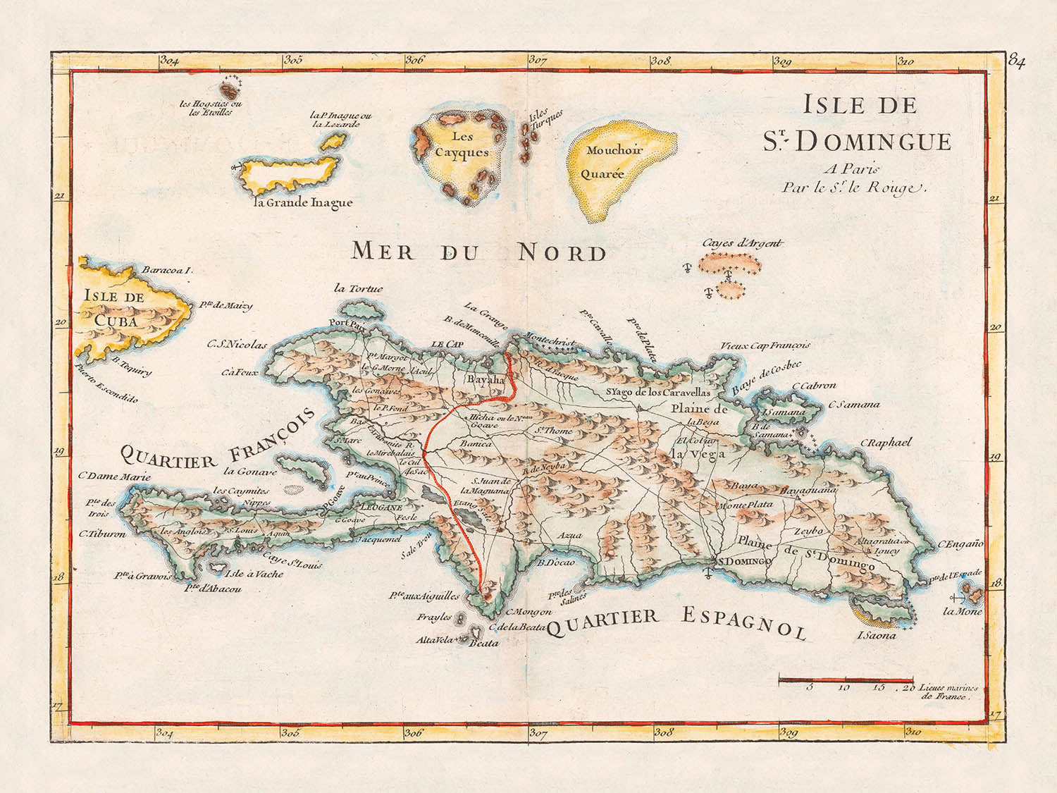
Step into the captivating world of 18th-century cartography with the "Isle De St. Domingue," a masterpiece by the renowned French cartographer Georges-Louis Le Rouge. Created in 1748, this map offers a detailed glimpse into the Caribbean's colonial past, showcasing the island of Hispaniola, now known as Haiti and the Dominican Republic. The map is part of Le Rouge's esteemed "Nouvel Atlas Portatif," a collection celebrated for its precision and artistry. With its vibrant hand-drawn illustrations and careful delineation of political boundaries, this map is a testament to the cartographic expertise of its time.
Georges-Louis Le Rouge was a pivotal figure in the world of 18th-century mapmaking. His works are celebrated for their accuracy and aesthetic appeal, reflecting the geopolitical interests of France during the colonial era. Le Rouge's maps not only served navigational purposes but also illustrated the territorial ambitions and divisions between European powers. This map, in particular, highlights the colonial rivalry between France and Spain, with a red line marking the division between their respective territories on the island.
The map vividly depicts the diverse geography of the region, from the rugged mountains to the expansive plains. The Mer du Nord (North Sea) is prominently featured, along with the surrounding islands such as Les Cayques and La Grande Inague. The intricate shading and relief work bring the topography to life, offering a glimpse into the natural beauty and strategic importance of these lands. Each element is meticulously crafted, reflecting the cartographer's dedication to detail and accuracy.
Cities and towns are marked with precision, offering a snapshot of the urban landscape during this period. In Haiti, notable settlements like Le Cap, Port-de-Paix, and Port-au-Prince are featured, while the Dominican Republic showcases Santo Domingo, La Vega, and Santiago de los Caballeros. These locations, bustling with colonial activity, were central to the economic and cultural exchanges of the era. The map serves as a historical document, capturing the essence of these vibrant communities.
Beyond its geographical and political significance, the "Isle De St. Domingue" map is a work of art. Its design reflects the elegance and sophistication of 18th-century cartography, with hand-colored illustrations that add depth and character. This map is not just a tool for navigation; it is a window into a bygone era, offering insights into the complex interplay of power, culture, and nature in the Caribbean. Owning this map is akin to holding a piece of history, a testament to the enduring allure of exploration and discovery.
Cities and towns on this map
- Haiti
- Le Cap
- Port-de-Paix
-
Port-au-Prince
-
Dominican Republic
- Santo Domingo
- La Vega
- Monte Plata
- Bayaha
- Santiago de los Caballeros
Notable Features & Landmarks
- Bodies of water:
-
Mer du Nord (North Sea)
-
Borders:
-
Red line indicating the division between French and Spanish territories.
-
Mountains:
-
Depicted with shaded relief.
-
Other notable features:
- Islands such as Les Cayques, La Grande Inague, and Mouchior Quaree.
Historical and design context
- Mapmaker/Publisher: Georges-Louis Le Rouge, a prominent French cartographer.
- Date created: 1748
- Design/Style:
- Typical 18th-century cartographic style with hand-drawn illustrations and coloring.
- Emphasizes both political boundaries and physical features.
- Historical significance:
- Illustrates colonial interests and territorial claims in the Caribbean during the 18th century.
- Provides insight into the geographic understanding of the period.
Please double check the images to make sure that a specific town or place is shown on this map. You can also get in touch and ask us to check the map for you.
This map looks great at every size, but I always recommend going for a larger size if you have space. That way you can easily make out all of the details.
This map looks amazing at sizes all the way up to 50in (125cm). If you are looking for a larger map, please get in touch.
The model in the listing images is holding the 18x24in (45x60cm) version of this map.
The fifth listing image shows an example of my map personalisation service.
If you’re looking for something slightly different, check out my collection of the best old maps to see if something else catches your eye.
Please contact me to check if a certain location, landmark or feature is shown on this map.
This would make a wonderful birthday, Christmas, Father's Day, work leaving, anniversary or housewarming gift for someone from the areas covered by this map.
This map is available as a giclée print on acid free archival matte paper, or you can buy it framed. The frame is a nice, simple black frame that suits most aesthetics. Please get in touch if you'd like a different frame colour or material. My frames are glazed with super-clear museum-grade acrylic (perspex/acrylite), which is significantly less reflective than glass, safer, and will always arrive in perfect condition.
This map is also available as a float framed canvas, sometimes known as a shadow gap framed canvas or canvas floater. The map is printed on artist's cotton canvas and then stretched over a handmade box frame. We then "float" the canvas inside a wooden frame, which is available in a range of colours (black, dark brown, oak, antique gold and white). This is a wonderful way to present a map without glazing in front. See some examples of float framed canvas maps and explore the differences between my different finishes.
For something truly unique, this map is also available in "Unique 3D", our trademarked process that dramatically transforms the map so that it has a wonderful sense of depth. We combine the original map with detailed topography and elevation data, so that mountains and the terrain really "pop". For more info and examples of 3D maps, check my Unique 3D page.
Many of our maps and art prints are chosen as thoughtful gifts for homes, offices, studies and meaningful places.
Choose a framed option for the easiest ready-to-hang gift, or choose an unframed print if the recipient may prefer to select their own frame.
We make orders locally in 23 countries around the world, so gifts can often be produced close to the recipient. This helps them arrive faster, travel more safely, and avoid customs or import duty surprises.
- We can deliver directly to the recipient
- Framed pieces arrive ready to hang
- Unframed prints are carefully packed in a strong protective tube
- Almost every order is made locally, for faster, safer gifting
- 90-day returns give the recipient time to decide
If you are not sure what to choose, please contact us. We can help you pick the right map, size, finish or delivery option.
Most orders are made locally and delivered in around 2–3 working days, depending on the product, size and destination.
We print and frame maps and artwork in 23 countries around the world, so your order is usually made close to you or your recipient. That means faster delivery, less time in transit, and no customs or import duty surprises.
Personalised and customised pieces usually take an extra 1–2 working days, because we prepare your design and send it to you for approval before printing.
Very large framed orders can take a little longer, as they need extra care in production and delivery.
Every order is carefully packaged: unframed prints are sent in a strong protective tube, while framed pieces are securely packed with protective materials around the frame.
If you need your order by a particular date, please contact us before ordering. We’ll check the best production route and delivery option for your location.
Express delivery is available at checkout for most countries. Next-day delivery is available in the UK, US, Singapore and the UAE.
Your order is covered by our 90-day returns policy and 5-year guarantee.
My standard frame is a gallery style black ash hardwood frame. It is simple and quite modern looking. My standard frame is around 20mm (0.8in) wide.
I use super-clear acrylic (perspex/acrylite) for the frame glass. It's lighter and safer than glass - and it looks better, as the reflectivity is lower.
Six standard frame colours are available for free (black, dark brown, dark grey, oak, white and antique gold). Custom framing and mounting/matting is available if you're looking for something else.
Most maps, art and illustrations are also available as a framed canvas. We use matte (not shiny) cotton canvas, stretch it over a sustainably sourced box wood frame, and then 'float' the piece within a wood frame. The end result is quite beautiful, and there's no glazing to get in the way.
All frames are provided "ready to hang", with either a string or brackets on the back. Very large frames will have heavy duty hanging plates and/or a mounting baton. If you have any questions, please get in touch.
See some examples of my framed maps and framed canvas maps.
Alternatively, I can also supply old maps and artwork on canvas, foam board, cotton rag and other materials.
If you want to frame your map or artwork yourself, please read my size guide first.
My maps are extremely high quality reproductions of original maps.
I source original, rare maps from libraries, auction houses and private collections around the world, restore them at my London workshop, and then use specialist giclée inks and printers to create beautiful maps that look even better than the original.
My maps are printed on acid-free archival matte (not glossy) paper that feels very high quality and almost like card. In technical terms the paper weight/thickness is 10mil/200gsm. It's perfect for framing.
I print with Epson ultrachrome giclée UV fade resistant pigment inks - some of the best inks you can find.
I can also make maps on canvas, cotton rag and other exotic materials.
Learn more about The Unique Maps Co.
Map personalisation
If you're looking for the perfect anniversary or housewarming gift, I can personalise your map to make it truly unique. For example, I can add a short message, or highlight an important location, or add your family's coat of arms.
The options are almost infinite. Please see my map personalisation page for some wonderful examples of what's possible.
To order a personalised map, select "personalise your map" before adding it to your basket.
Get in touch if you're looking for more complex customisations and personalisations.
Map ageing
I have been asked hundreds of times over the years by customers if they could buy a map that looks even older.
Well, now you can, by selecting Aged before you add a map to your basket.
All the product photos you see on this page show the map in its Original form. This is what the map looks like today.
If you select Aged, I will age your map by hand, using a special and unique process developed through years of studying old maps, talking to researchers to understand the chemistry of aging paper, and of course... lots of practice!
If you're unsure, stick to the Original colour of the map. If you want something a bit darker and older looking, go for Aged.
If you are not happy with your order for any reason, contact me and I'll get it fixed ASAP, free of charge. Please see my returns and refund policy for more information.
I am very confident you will like your restored map or art print. I have been doing this since 1984. I'm a 5-star Etsy seller. I have sold tens of thousands of maps and art prints and have over 5,000 real 5-star reviews. My work has been featured in interior design magazines, on the BBC, and on the walls of dozens of 5-star hotels.
I use a unique process to restore maps and artwork that is massively time consuming and labour intensive. Hunting down the original maps and illustrations can take months. I use state of the art and eye-wateringly expensive technology to scan and restore them. As a result, I guarantee my maps and art prints are a cut above the rest. I stand by my products and will always make sure you're 100% happy with what you receive.
Almost all of my maps and art prints look amazing at large sizes (200cm, 6.5ft+) and I can frame and deliver them to you as well, via special oversized courier. Contact me to discuss your specific needs.
Or try searching for something!


