

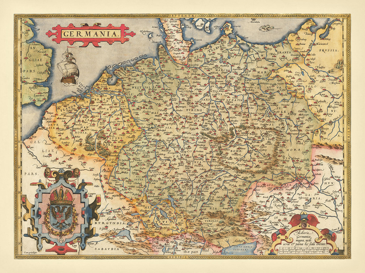


Rare Old Map of Germany, the Holy Roman Empire by Ortelius, 1573: Germania, Poland, Rhine, Elbe, Danube, Alps, Baltic Sea
The Collector’s Offer
Choose two eligible works and receive 20% off both. Choose three and the lowest-priced one is complimentary, a maximum saving of 33%.
Mix and match eligible standard maps and fine-art prints. No code is required; the offer is applied automatically at checkout.
Standard made-to-order configurations are included. Bespoke sizes, personalised designs and commissioned work are excluded.
Need delivery to different addresses? Contact us before ordering.The Collector’s Offer
Choose two eligible works and receive 20% off both. Choose three and the lowest-priced one is complimentary, a maximum saving of 33%.
Mix and match eligible standard maps and fine-art prints. No code is required; the offer is applied automatically at checkout.
Standard made-to-order configurations are included. Bespoke sizes, personalised designs and commissioned work are excluded.
Need delivery to different addresses? Contact us before ordering. Restored in London • Made in the UK

Restored from the original 1573 map and printed to museum-grade archival standards. Read the story behind this map
Choose your size
Choose your finish


(More info)
Gift message & custom finish

If you want to add a gift message, or a finish (jigsaw, aluminium board, etc.) that is not available here, please request it in the "order note" when you check out.
Every order is custom made, so if you need the size adjusted slightly, or printed on an unusual material, just let us know. We've done thousands of custom orders over the years, so there's (almost) nothing we can't manage.
You can also contact us before you order, if you prefer!

- Made in the UK for fast, safe delivery
- Next day delivery available
- Need advice? Call us or message on WhatsApp
Own a piece of history
8,000+ five-star reviews


"Germania," a masterful creation by the renowned Flemish cartographer Abraham Ortelius, offers an unparalleled glimpse into the Holy Roman Empire as it...
Continue reading"Germania," a masterful creation by the renowned Flemish cartographer Abraham Ortelius, offers an unparalleled glimpse into the Holy Roman Empire as it stood in 1573. This map, originally published in Ortelius's groundbreaking atlas "Theatrum Orbis Terrarum," was the most influential representation of the region during its time. It meticulously details a vast expanse from the English Channel to the Baltic Sea, and from the Vistula and Poland in the northeast to Budapest and Venice in the southeast, extending as far south as Milan and Geneva. Ortelius's dedication to accuracy and detail is evident in every inch of this cartographic masterpiece.
Ortelius's map is a testament to the scholarly rigor and artistic finesse of the late 16th century. The map's detailed depiction of cities, rivers, and other landmarks showcases Ortelius's commitment to providing an accurate geographical account. Notable features include the Rhine, Elbe, and Danube rivers, which snake through the landscape, connecting a network of cities and towns that were pivotal to the Holy Roman Empire. The map also highlights the mountainous regions in the southeast, including the majestic Alps, adding a layer of topographical depth to the political boundaries.
The artistic elements of "Germania" are as captivating as its geographical precision. The lower-left corner of the map features a coat of arms, likely representing Maximilian II, the Holy Roman Emperor, adding a regal touch to the cartographic work. The illustration of a ship in the English Channel and a sea monster in the Baltic Sea not only enhance the map's visual appeal but also reflect the maritime myths and artistic conventions of the era. These elements, combined with the old color palette, make the map a true work of art.
Ortelius's map draws from a rich tapestry of sources, reflecting the collaborative nature of cartography in the 16th century. His primary reference was a nine-sheet map by Christiaan Sgrooten, known for its unparalleled detail and accuracy. Ortelius also incorporated insights from other esteemed cartographers, including Carolus Heydanus, Gerardus Mercator, Sebastian Munster, and Tilemannus Stella. This amalgamation of knowledge ensured that "Germania" was not only accurate but also comprehensive, making it a valuable resource for scholars and the upper echelons of European society.
The historical significance of "Germania" cannot be overstated. As the most widely circulated map of the Holy Roman Empire among scholars and the elite, it played a crucial role in shaping contemporary understanding of the region's geography and political landscape. This map is more than just a geographical representation; it is a window into the past, offering insights into the political, cultural, and artistic milieu of the late 16th century. Owning this map is akin to holding a piece of history, a testament to the enduring legacy of Abraham Ortelius and his contributions to the world of cartography.
Cities and towns on this map
- Germany
- Berlin
- Hamburg
- Munich
- Cologne
- Frankfurt
- Stuttgart
- Düsseldorf
- Dresden
- Leipzig
- Nuremberg
- Hanover
- Bremen
- Dortmund
- Essen
- Duisburg
- Bochum
- Wuppertal
- Bielefeld
- Bonn
- Münster
- Karlsruhe
- Mannheim
- Augsburg
- Wiesbaden
- Gelsenkirchen
- Mönchengladbach
- Braunschweig
- Chemnitz
- Kiel
- Aachen
- Halle (Saale)
- Magdeburg
- Freiburg
- Krefeld
- Lübeck
- Oberhausen
- Erfurt
- Mainz
- Rostock
- Kassel
- Hagen
- Saarbrücken
- Hamm
- Mülheim
- Potsdam
- Ludwigshafen
- Oldenburg
- Leverkusen
- Osnabrück
- Solingen
- Herne
- Neuss
- Heidelberg
- Darmstadt
- Paderborn
- Regensburg
- Ingolstadt
- Würzburg
- Wolfsburg
- Fürth
- Ulm
- Offenbach
- Heilbronn
- Pforzheim
- Göttingen
- Bottrop
- Trier
- Recklinghausen
- Reutlingen
- Bremerhaven
- Koblenz
- Bergisch Gladbach
- Jena
- Remscheid
- Erlangen
- Moers
- Siegen
- Hildesheim
- Salzgitter
- Poland
- Warsaw
- Kraków
- Łódź
- Wrocław
- Poznań
- Gdańsk
- Szczecin
- Bydgoszcz
- Lublin
- Katowice
- Białystok
- Gdynia
- Częstochowa
- Radom
- Sosnowiec
- Toruń
- Kielce
- Gliwice
- Zabrze
- Bytom
- Olsztyn
- Rzeszów
- Ruda Śląska
- Rybnik
- Tychy
- Dąbrowa Górnicza
- Opole
- Płock
- Elbląg
- Wałbrzych
- Gorzów Wielkopolski
- Włocławek
- Zielona Góra
- Tarnów
- Chorzów
- Koszalin
- Kalisz
- Legnica
- Grudziądz
- Słupsk
- Jaworzno
- Jastrzębie-Zdrój
- Nowy Sącz
- Jelenia Góra
- Siedlce
- Mysłowice
- Piła
- Ostrowiec Świętokrzyski
- Siemianowice Śląskie
Notable Features & Landmarks
- Illustrations:
- Ship in the English Channel.
- Sea monster in the Baltic Sea.
- Coat of arms in the lower-left corner.
- Bodies of Water:
- English Channel
- Baltic Sea
- Various rivers (e.g., Elbe, Rhine, Danube)
- Borders:
- Boundaries of the Holy Roman Empire.
- Mountains:
- Mountain ranges in the southeastern part of the map (e.g., Alps).
Historical and design context
- Mapmaker: Abraham Ortelius, a Flemish cartographer known for creating the first modern atlas of the world.
- Date: 1573
- Original Title: Germania
- Influence: The most influential map of the Holy Roman Empire in its time, widely circulated among scholars and the upper castes of Europe.
- Coverage: Vast region from the English Channel to the Baltic, and from the Vistula and Poland in the northeast to Budapest, Venice in the southeast, and reaching Milan and Geneva in the south.
- Detail: Meticulously details cities, rivers, and other landmarks.
- Artistic Elements: Includes a coat of arms, ship illustration, and sea monster, reflecting the artistic style and maritime myths of the era.
- Sources: Primary reference was a nine-sheet map by Christiaan Sgrooten, with additional insights from Carolus Heydanus, Gerardus Mercator, Sebastian Munster, and Tilemannus Stella.
- Historical Significance: A significant representation of the Holy Roman Empire in the late 16th century, widely used by scholars and the elite.
Please double check the images to make sure that a specific town or place is shown on this map. You can also get in touch and ask us to check the map for you.
This map looks great at every size, but I always recommend going for a larger size if you have space. That way you can easily make out all of the details.
This map looks amazing at sizes all the way up to 90in (230cm). If you are looking for a larger map, please get in touch.
The model in the listing images is holding the 18x24in (45x60cm) version of this map.
The fifth listing image shows an example of my map personalisation service.
If you’re looking for something slightly different, check out my collection of the best old maps to see if something else catches your eye.
Please contact me to check if a certain location, landmark or feature is shown on this map.
This would make a wonderful birthday, Christmas, Father's Day, work leaving, anniversary or housewarming gift for someone from the areas covered by this map.
This map is available as a giclée print on acid free archival matte paper, or you can buy it framed. The frame is a nice, simple black frame that suits most aesthetics. Please get in touch if you'd like a different frame colour or material. My frames are glazed with super-clear museum-grade acrylic (perspex/acrylite), which is significantly less reflective than glass, safer, and will always arrive in perfect condition.
This map is also available as a float framed canvas, sometimes known as a shadow gap framed canvas or canvas floater. The map is printed on artist's cotton canvas and then stretched over a handmade box frame. We then "float" the canvas inside a wooden frame, which is available in a range of colours (black, dark brown, oak, antique gold and white). This is a wonderful way to present a map without glazing in front. See some examples of float framed canvas maps and explore the differences between my different finishes.
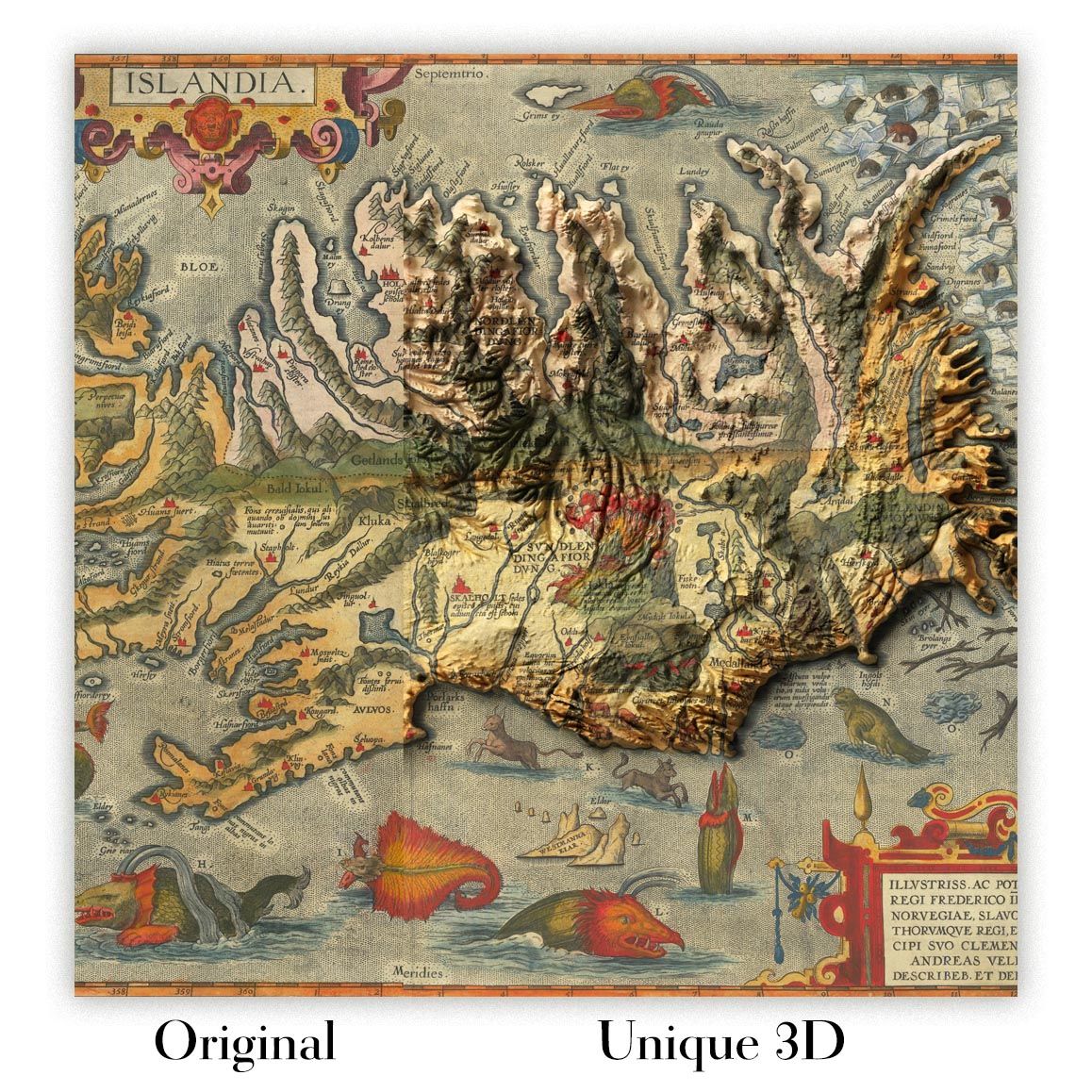
For something truly unique, this map is also available in "Unique 3D", our trademarked process that dramatically transforms the map so that it has a wonderful sense of depth. We combine the original map with detailed topography and elevation data, so that mountains and the terrain really "pop". For more info and examples of 3D maps, check my Unique 3D page.
"Germania," a masterful creation by the renowned Flemish cartographer Abraham Ortelius, offers an unparalleled glimpse into the Holy Roman Empire as it stood in 1573. This map, originally published in Ortelius's groundbreaking atlas "Theatrum Orbis Terrarum," was the most influential representation of the region during its time. It meticulously details a vast expanse from the English Channel to the Baltic Sea, and from the Vistula and Poland in the northeast to Budapest and Venice in the southeast, extending as far south as Milan and Geneva. Ortelius's dedication to accuracy and detail is evident in every inch of this cartographic masterpiece.
Ortelius's map is a testament to the scholarly rigor and artistic finesse of the late 16th century. The map's detailed depiction of cities, rivers, and other landmarks showcases Ortelius's commitment to providing an accurate geographical account. Notable features include the Rhine, Elbe, and Danube rivers, which snake through the landscape, connecting a network of cities and towns that were pivotal to the Holy Roman Empire. The map also highlights the mountainous regions in the southeast, including the majestic Alps, adding a layer of topographical depth to the political boundaries.
The artistic elements of "Germania" are as captivating as its geographical precision. The lower-left corner of the map features a coat of arms, likely representing Maximilian II, the Holy Roman Emperor, adding a regal touch to the cartographic work. The illustration of a ship in the English Channel and a sea monster in the Baltic Sea not only enhance the map's visual appeal but also reflect the maritime myths and artistic conventions of the era. These elements, combined with the old color palette, make the map a true work of art.
Ortelius's map draws from a rich tapestry of sources, reflecting the collaborative nature of cartography in the 16th century. His primary reference was a nine-sheet map by Christiaan Sgrooten, known for its unparalleled detail and accuracy. Ortelius also incorporated insights from other esteemed cartographers, including Carolus Heydanus, Gerardus Mercator, Sebastian Munster, and Tilemannus Stella. This amalgamation of knowledge ensured that "Germania" was not only accurate but also comprehensive, making it a valuable resource for scholars and the upper echelons of European society.
The historical significance of "Germania" cannot be overstated. As the most widely circulated map of the Holy Roman Empire among scholars and the elite, it played a crucial role in shaping contemporary understanding of the region's geography and political landscape. This map is more than just a geographical representation; it is a window into the past, offering insights into the political, cultural, and artistic milieu of the late 16th century. Owning this map is akin to holding a piece of history, a testament to the enduring legacy of Abraham Ortelius and his contributions to the world of cartography.
Cities and towns on this map
- Germany
- Berlin
- Hamburg
- Munich
- Cologne
- Frankfurt
- Stuttgart
- Düsseldorf
- Dresden
- Leipzig
- Nuremberg
- Hanover
- Bremen
- Dortmund
- Essen
- Duisburg
- Bochum
- Wuppertal
- Bielefeld
- Bonn
- Münster
- Karlsruhe
- Mannheim
- Augsburg
- Wiesbaden
- Gelsenkirchen
- Mönchengladbach
- Braunschweig
- Chemnitz
- Kiel
- Aachen
- Halle (Saale)
- Magdeburg
- Freiburg
- Krefeld
- Lübeck
- Oberhausen
- Erfurt
- Mainz
- Rostock
- Kassel
- Hagen
- Saarbrücken
- Hamm
- Mülheim
- Potsdam
- Ludwigshafen
- Oldenburg
- Leverkusen
- Osnabrück
- Solingen
- Herne
- Neuss
- Heidelberg
- Darmstadt
- Paderborn
- Regensburg
- Ingolstadt
- Würzburg
- Wolfsburg
- Fürth
- Ulm
- Offenbach
- Heilbronn
- Pforzheim
- Göttingen
- Bottrop
- Trier
- Recklinghausen
- Reutlingen
- Bremerhaven
- Koblenz
- Bergisch Gladbach
- Jena
- Remscheid
- Erlangen
- Moers
- Siegen
- Hildesheim
- Salzgitter
- Poland
- Warsaw
- Kraków
- Łódź
- Wrocław
- Poznań
- Gdańsk
- Szczecin
- Bydgoszcz
- Lublin
- Katowice
- Białystok
- Gdynia
- Częstochowa
- Radom
- Sosnowiec
- Toruń
- Kielce
- Gliwice
- Zabrze
- Bytom
- Olsztyn
- Rzeszów
- Ruda Śląska
- Rybnik
- Tychy
- Dąbrowa Górnicza
- Opole
- Płock
- Elbląg
- Wałbrzych
- Gorzów Wielkopolski
- Włocławek
- Zielona Góra
- Tarnów
- Chorzów
- Koszalin
- Kalisz
- Legnica
- Grudziądz
- Słupsk
- Jaworzno
- Jastrzębie-Zdrój
- Nowy Sącz
- Jelenia Góra
- Siedlce
- Mysłowice
- Piła
- Ostrowiec Świętokrzyski
- Siemianowice Śląskie
Notable Features & Landmarks
- Illustrations:
- Ship in the English Channel.
- Sea monster in the Baltic Sea.
- Coat of arms in the lower-left corner.
- Bodies of Water:
- English Channel
- Baltic Sea
- Various rivers (e.g., Elbe, Rhine, Danube)
- Borders:
- Boundaries of the Holy Roman Empire.
- Mountains:
- Mountain ranges in the southeastern part of the map (e.g., Alps).
Historical and design context
- Mapmaker: Abraham Ortelius, a Flemish cartographer known for creating the first modern atlas of the world.
- Date: 1573
- Original Title: Germania
- Influence: The most influential map of the Holy Roman Empire in its time, widely circulated among scholars and the upper castes of Europe.
- Coverage: Vast region from the English Channel to the Baltic, and from the Vistula and Poland in the northeast to Budapest, Venice in the southeast, and reaching Milan and Geneva in the south.
- Detail: Meticulously details cities, rivers, and other landmarks.
- Artistic Elements: Includes a coat of arms, ship illustration, and sea monster, reflecting the artistic style and maritime myths of the era.
- Sources: Primary reference was a nine-sheet map by Christiaan Sgrooten, with additional insights from Carolus Heydanus, Gerardus Mercator, Sebastian Munster, and Tilemannus Stella.
- Historical Significance: A significant representation of the Holy Roman Empire in the late 16th century, widely used by scholars and the elite.
Please double check the images to make sure that a specific town or place is shown on this map. You can also get in touch and ask us to check the map for you.
This map looks great at every size, but I always recommend going for a larger size if you have space. That way you can easily make out all of the details.
This map looks amazing at sizes all the way up to 90in (230cm). If you are looking for a larger map, please get in touch.
The model in the listing images is holding the 18x24in (45x60cm) version of this map.
The fifth listing image shows an example of my map personalisation service.
If you’re looking for something slightly different, check out my collection of the best old maps to see if something else catches your eye.
Please contact me to check if a certain location, landmark or feature is shown on this map.
This would make a wonderful birthday, Christmas, Father's Day, work leaving, anniversary or housewarming gift for someone from the areas covered by this map.
This map is available as a giclée print on acid free archival matte paper, or you can buy it framed. The frame is a nice, simple black frame that suits most aesthetics. Please get in touch if you'd like a different frame colour or material. My frames are glazed with super-clear museum-grade acrylic (perspex/acrylite), which is significantly less reflective than glass, safer, and will always arrive in perfect condition.
This map is also available as a float framed canvas, sometimes known as a shadow gap framed canvas or canvas floater. The map is printed on artist's cotton canvas and then stretched over a handmade box frame. We then "float" the canvas inside a wooden frame, which is available in a range of colours (black, dark brown, oak, antique gold and white). This is a wonderful way to present a map without glazing in front. See some examples of float framed canvas maps and explore the differences between my different finishes.
For something truly unique, this map is also available in "Unique 3D", our trademarked process that dramatically transforms the map so that it has a wonderful sense of depth. We combine the original map with detailed topography and elevation data, so that mountains and the terrain really "pop". For more info and examples of 3D maps, check my Unique 3D page.
Many of our maps and art prints are chosen as thoughtful gifts for homes, offices, studies and meaningful places.
Choose a framed option for the easiest ready-to-hang gift, or choose an unframed print if the recipient may prefer to select their own frame.
We make orders locally in 23 countries around the world, so gifts can often be produced close to the recipient. This helps them arrive faster, travel more safely, and avoid customs or import duty surprises.
- We can deliver directly to the recipient
- Framed pieces arrive ready to hang
- Unframed prints are carefully packed in a strong protective tube
- Almost every order is made locally, for faster, safer gifting
- 90-day returns give the recipient time to decide
If you are not sure what to choose, please contact us. We can help you pick the right map, size, finish or delivery option.
Most orders are made locally and delivered in around 2–3 working days, depending on the product, size and destination.
We print and frame maps and artwork in 23 countries around the world, so your order is usually made close to you or your recipient. That means faster delivery, less time in transit, and no customs or import duty surprises.
Personalised and customised pieces usually take an extra 1–2 working days, because we prepare your design and send it to you for approval before printing.
Very large framed orders can take a little longer, as they need extra care in production and delivery.
Every order is carefully packaged: unframed prints are sent in a strong protective tube, while framed pieces are securely packed with protective materials around the frame.
If you need your order by a particular date, please contact us before ordering. We’ll check the best production route and delivery option for your location.
Express delivery is available at checkout for most countries. Next-day delivery is available in the UK, US, Singapore and the UAE.
Your order is covered by our 90-day returns policy and 10-year guarantee.
Our standard frame is a gallery-style black ash hardwood frame, with a simple, modern look. It is approximately 20mm (0.8in) wide. You can also view some lovely customer photos of framed maps and art.
We use super-clear acrylic glazing, also known as Perspex or Acrylite, instead of traditional glass. It is lighter, safer, and has lower reflectivity, giving the artwork a clearer, cleaner appearance.
Six standard frame colours are available at no extra cost: black, dark brown, dark grey, oak, white, and antique gold. Custom framing and mounting/matting is also available for customers looking for something more specific.
Most maps, art prints, and illustrations are also available as a framed canvas. We use matte cotton canvas, stretch it over a sustainably sourced wooden box frame, and then float the piece within a wooden outer frame. The finished result is beautifully presented, with no glazing between you and the artwork.
All frames are supplied ready to hang, with either string or brackets fitted to the back. Very large frames will include heavy-duty hanging plates and/or a mounting baton. If you have any questions, please get in touch.
We can also supply old maps and artwork on canvas, foam board, cotton rag, and other materials.
If you would prefer to frame your map or artwork yourself, please read our size guide before ordering.
Every Unique Maps piece begins with an authentic cartographic source or an original design from our London studio.
For our historic maps, we source rare originals from libraries, archives, auction houses and private collections around the world. We carefully restore each map for print—repairing age-related damage, balancing colour and improving clarity while preserving its original detail, texture and character.
Once restored, the map is prepared for your chosen size and finish. Your piece is then printed and, where selected, framed close to its delivery destination.
Our map prints use acid-free 200gsm archival matte paper and fade-resistant pigment inks, creating a rich, non-glossy finish designed to last. Framed maps use crystal-clear optical acrylic and arrive ready to hang.
Canvas, cotton-rag and other specialist presentations are also available. Learn more about our materials and finishes.
Personalising your map
You can add a short title or dedication, mark one meaningful place, or request one considered visual detail. For personalised designs, we send a proof before printing and you can request changes before approval.
For more complex bespoke commissions, contact our design team.
Original or Aged
Choose Original for true-to-source colour, or Aged for a warmer, richer antique character created with our specialist ageing process. See examples of our Aged maps.
If you are not happy with your order for any reason, contact me and I'll get it fixed ASAP, free of charge. Please see my returns and refund policy for more information.
I am very confident you will like your restored map or art print. I have been doing this since 1984. I'm a 5-star Etsy seller. I have sold tens of thousands of maps and art prints and have over 5,000 real 5-star reviews. My work has been featured in interior design magazines, on the BBC, and on the walls of dozens of 5-star hotels.
I use a unique process to restore maps and artwork that is massively time consuming and labour intensive. Hunting down the original maps and illustrations can take months. I use state of the art and eye-wateringly expensive technology to scan and restore them. As a result, I guarantee my maps and art prints are a cut above the rest. I stand by my products and will always make sure you're 100% happy with what you receive.
Almost all of my maps and art prints look amazing at large sizes (200cm, 6.5ft+) and I can frame and deliver them to you as well, via special oversized courier. Contact me to discuss your specific needs.
Or try searching for something!


