


Rare Old Map of Forests & National Parks in the Western USA by USGS, 1900: Yellowstone, Sierra Nevada, Etc.
The Collector’s Offer
Choose two eligible works and receive 20% off both. Choose three and the lowest-priced one is complimentary, a maximum saving of 33%.
Mix and match eligible standard maps and fine-art prints. No code is required; the offer is applied automatically at checkout.
Standard made-to-order configurations are included. Bespoke sizes, personalised designs and commissioned work are excluded.
Need delivery to different addresses? Contact us before ordering.The Collector’s Offer
Choose two eligible works and receive 20% off both. Choose three and the lowest-priced one is complimentary, a maximum saving of 33%.
Mix and match eligible standard maps and fine-art prints. No code is required; the offer is applied automatically at checkout.
Standard made-to-order configurations are included. Bespoke sizes, personalised designs and commissioned work are excluded.
Need delivery to different addresses? Contact us before ordering. Restored in London • Made in the UK

Restored from the original 1900 map and printed to museum-grade archival standards. Read the story behind this map
Choose your size
Choose your finish


(More info)
Gift message & custom finish

If you want to add a gift message, or a finish (jigsaw, aluminium board, etc.) that is not available here, please request it in the "order note" when you check out.
Every order is custom made, so if you need the size adjusted slightly, or printed on an unusual material, just let us know. We've done thousands of custom orders over the years, so there's (almost) nothing we can't manage.
You can also contact us before you order, if you prefer!

- Made in the UK for fast, safe delivery
- Next day delivery available
- Need advice? Call us or message on WhatsApp
Own a piece of history
8,000+ five-star reviews


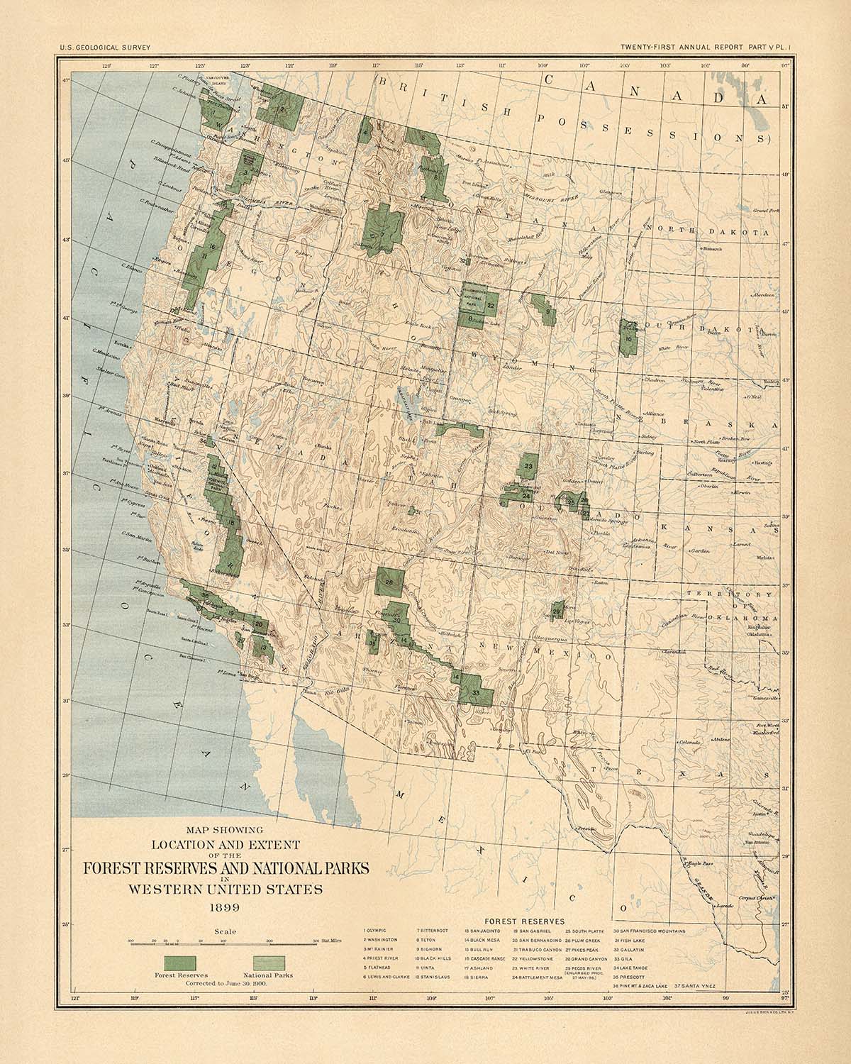
Step into the dawn of American conservation with "Plate I. The Forest Reserves and National Parks in Western United States, 1899," a...
Continue readingStep into the dawn of American conservation with "Plate I. The Forest Reserves and National Parks in Western United States, 1899," a masterwork of cartographic history crafted by the venerable US Geological Survey (USGS) in 1900. This map is a visual testament to a pivotal era, when the United States first turned its attention to preserving the wild grandeur of its western lands. The map’s original title alone evokes the ambition and vision of the age, as it meticulously charts the newly established National Parks and Forest Reserves west of the 97th meridian. This was a time when the boundaries of wilderness and civilization were still being negotiated, and the contours of the American landscape were being formally inscribed for the very first time.
The USGS, established in 1879, was at the forefront of this monumental task, bringing scientific rigor and artistic precision to the mapping of the nation’s most treasured natural regions. Their expertise is evident in the elegant use of contour lines and subtle color gradations, which together bring to life the rugged relief of the Sierra Nevada, Cascade Range, and Rocky Mountains. Every detail, from the demarcation of state borders to the careful shading of protected lands, reflects the Survey’s dual commitment to accuracy and beauty. This map is not only a navigational tool but a work of art, capturing the interplay of geography, policy, and natural wonder at the turn of the 20th century.
The map’s thematic focus is both timely and visionary. At its heart are the great National Parks and Forest Reserves—Yellowstone, Lewis and Clarke, Mount Rainier, Olympic, Cascade Range, Stanislaus, and Lake Tahoe—each boldly delineated as beacons of the nascent conservation movement. These protected areas, highlighted in distinct colors, stand in contrast to the surrounding unreserved lands, underscoring the early federal commitment to safeguarding America’s forests and watersheds. The map also captures the sweep of major mountain ranges and the subtle undulations of the western landscape, inviting the viewer to trace the paths of rivers, follow the rise of peaks, and imagine the forests as they once stood.
Beyond its visual allure, this map is a key to understanding the historical context of American land management. Published as part of a monumental 711-page collection, it was accompanied by detailed reports on the classification of lands and the condition of timber resources, authored by some of the era’s leading scientific minds. These documents provide a window into the challenges and triumphs of early conservationists, whose efforts laid the groundwork for the modern National Forest and National Park systems. The map itself thus serves as both a snapshot of a formative moment and a touchstone for anyone interested in the evolution of American environmental policy.
Anchoring the wilderness are the burgeoning cities and towns of the West—San Francisco, Los Angeles, Seattle, Denver, and others—each labeled with care and set against the vastness of their natural surroundings. These settlements, now metropolises, were then outposts on the edge of the unknown, their fortunes intertwined with the fate of the forests and mountains that surrounded them. This juxtaposition of civilization and wilderness, rendered with such skill by the USGS, makes the map a powerful artifact of American identity—one that speaks to the enduring tension between development and preservation, and the timeless allure of the wild frontier.
Cities and towns on this map
- California:
- San Francisco
- Los Angeles
- San Diego
- Sacramento
- Washington:
- Seattle
- Spokane
- Tacoma
- Oregon:
- Portland
- Colorado:
- Denver
- Arizona:
- Phoenix
- Utah:
- Salt Lake City
Notable Features & Landmarks
- National Parks are clearly labeled and highlighted, including Yellowstone National Park.
- Forest Reserves are distinctly marked, such as:
- Lewis and Clarke Forest Reserve (Montana)
- Mount Rainier Forest Reserve (Washington)
- Olympic Forest Reserve (Washington)
- Cascade Range Forest Reserve (Oregon/Washington)
- Stanislaus Forest Reserve (California)
- Lake Tahoe Forest Reserve (California/Nevada)
- State boundaries are clearly delineated.
- Major mountain ranges, such as the Sierra Nevada, Cascade Range, and Rocky Mountains, are depicted with relief contours.
- The 97th meridian west is marked as the eastern boundary of the map’s focus.
- Color shading is used to differentiate forest reserves and national parks from other lands.
Historical and design context
- Name of the map: Plate I. The Forest Reserves and National Parks in Western United States, 1899.
- Date of creation: Map updated to June 30, 1900; published by the US Geological Survey (USGS) in 1900.
- Mapmaker/publisher: US Geological Survey (USGS), a federal scientific agency established in 1879, known for mapping and studying the natural resources and landscapes of the United States.
- Geographic coverage: Focuses on the western United States, specifically areas west of the 97th meridian west, including states such as California, Oregon, Washington, Idaho, Montana, Wyoming, Colorado, Utah, Arizona, and New Mexico.
- Map type: County or State Thematic map, emphasizing land management and conservation themes.
- Main topics and themes: Depicts National Parks and Forest Reserves, highlighting early federal conservation efforts and land classifications at the turn of the 20th century.
- Design/style: Relief is shown using contour lines and color, enhancing the visualization of mountainous and forested regions.
- Historical significance: The map is part of a larger publication (711 pages, 39 maps) that documents the early development and management of U.S. forest reserves, reflecting the growing conservation movement of the era.
- Contextual importance: Provides a comprehensive overview of federal land management, conservation policies, and the geographical distribution of protected areas in the western U.S. around 1900.
- Notable for: Being a primary source for historians studying the origins of the U.S. National Forest and National Park systems.
Please double check the images to make sure that a specific town or place is shown on this map. You can also get in touch and ask us to check the map for you.
This map looks great at every size, but I always recommend going for a larger size if you have space. That way you can easily make out all of the details.
This map looks amazing at sizes all the way up to 50in (125cm). If you are looking for a larger map, please get in touch.
The model in the listing images is holding the 16x20in (40x50cm) version of this map.
The fifth listing image shows an example of my map personalisation service.
If you’re looking for something slightly different, check out my collection of the best old maps to see if something else catches your eye.
Please contact me to check if a certain location, landmark or feature is shown on this map.
This would make a wonderful birthday, Christmas, Father's Day, work leaving, anniversary or housewarming gift for someone from the areas covered by this map.
This map is available as a giclée print on acid free archival matte paper, or you can buy it framed. The frame is a nice, simple black frame that suits most aesthetics. Please get in touch if you'd like a different frame colour or material. My frames are glazed with super-clear museum-grade acrylic (perspex/acrylite), which is significantly less reflective than glass, safer, and will always arrive in perfect condition.
This map is also available as a float framed canvas, sometimes known as a shadow gap framed canvas or canvas floater. The map is printed on artist's cotton canvas and then stretched over a handmade box frame. We then "float" the canvas inside a wooden frame, which is available in a range of colours (black, dark brown, oak, antique gold and white). This is a wonderful way to present a map without glazing in front. See some examples of float framed canvas maps and explore the differences between my different finishes.
For something truly unique, this map is also available in "Unique 3D", our trademarked process that dramatically transforms the map so that it has a wonderful sense of depth. We combine the original map with detailed topography and elevation data, so that mountains and the terrain really "pop". For more info and examples of 3D maps, check my Unique 3D page.
Step into the dawn of American conservation with "Plate I. The Forest Reserves and National Parks in Western United States, 1899," a masterwork of cartographic history crafted by the venerable US Geological Survey (USGS) in 1900. This map is a visual testament to a pivotal era, when the United States first turned its attention to preserving the wild grandeur of its western lands. The map’s original title alone evokes the ambition and vision of the age, as it meticulously charts the newly established National Parks and Forest Reserves west of the 97th meridian. This was a time when the boundaries of wilderness and civilization were still being negotiated, and the contours of the American landscape were being formally inscribed for the very first time.
The USGS, established in 1879, was at the forefront of this monumental task, bringing scientific rigor and artistic precision to the mapping of the nation’s most treasured natural regions. Their expertise is evident in the elegant use of contour lines and subtle color gradations, which together bring to life the rugged relief of the Sierra Nevada, Cascade Range, and Rocky Mountains. Every detail, from the demarcation of state borders to the careful shading of protected lands, reflects the Survey’s dual commitment to accuracy and beauty. This map is not only a navigational tool but a work of art, capturing the interplay of geography, policy, and natural wonder at the turn of the 20th century.
The map’s thematic focus is both timely and visionary. At its heart are the great National Parks and Forest Reserves—Yellowstone, Lewis and Clarke, Mount Rainier, Olympic, Cascade Range, Stanislaus, and Lake Tahoe—each boldly delineated as beacons of the nascent conservation movement. These protected areas, highlighted in distinct colors, stand in contrast to the surrounding unreserved lands, underscoring the early federal commitment to safeguarding America’s forests and watersheds. The map also captures the sweep of major mountain ranges and the subtle undulations of the western landscape, inviting the viewer to trace the paths of rivers, follow the rise of peaks, and imagine the forests as they once stood.
Beyond its visual allure, this map is a key to understanding the historical context of American land management. Published as part of a monumental 711-page collection, it was accompanied by detailed reports on the classification of lands and the condition of timber resources, authored by some of the era’s leading scientific minds. These documents provide a window into the challenges and triumphs of early conservationists, whose efforts laid the groundwork for the modern National Forest and National Park systems. The map itself thus serves as both a snapshot of a formative moment and a touchstone for anyone interested in the evolution of American environmental policy.
Anchoring the wilderness are the burgeoning cities and towns of the West—San Francisco, Los Angeles, Seattle, Denver, and others—each labeled with care and set against the vastness of their natural surroundings. These settlements, now metropolises, were then outposts on the edge of the unknown, their fortunes intertwined with the fate of the forests and mountains that surrounded them. This juxtaposition of civilization and wilderness, rendered with such skill by the USGS, makes the map a powerful artifact of American identity—one that speaks to the enduring tension between development and preservation, and the timeless allure of the wild frontier.
Cities and towns on this map
- California:
- San Francisco
- Los Angeles
- San Diego
- Sacramento
- Washington:
- Seattle
- Spokane
- Tacoma
- Oregon:
- Portland
- Colorado:
- Denver
- Arizona:
- Phoenix
- Utah:
- Salt Lake City
Notable Features & Landmarks
- National Parks are clearly labeled and highlighted, including Yellowstone National Park.
- Forest Reserves are distinctly marked, such as:
- Lewis and Clarke Forest Reserve (Montana)
- Mount Rainier Forest Reserve (Washington)
- Olympic Forest Reserve (Washington)
- Cascade Range Forest Reserve (Oregon/Washington)
- Stanislaus Forest Reserve (California)
- Lake Tahoe Forest Reserve (California/Nevada)
- State boundaries are clearly delineated.
- Major mountain ranges, such as the Sierra Nevada, Cascade Range, and Rocky Mountains, are depicted with relief contours.
- The 97th meridian west is marked as the eastern boundary of the map’s focus.
- Color shading is used to differentiate forest reserves and national parks from other lands.
Historical and design context
- Name of the map: Plate I. The Forest Reserves and National Parks in Western United States, 1899.
- Date of creation: Map updated to June 30, 1900; published by the US Geological Survey (USGS) in 1900.
- Mapmaker/publisher: US Geological Survey (USGS), a federal scientific agency established in 1879, known for mapping and studying the natural resources and landscapes of the United States.
- Geographic coverage: Focuses on the western United States, specifically areas west of the 97th meridian west, including states such as California, Oregon, Washington, Idaho, Montana, Wyoming, Colorado, Utah, Arizona, and New Mexico.
- Map type: County or State Thematic map, emphasizing land management and conservation themes.
- Main topics and themes: Depicts National Parks and Forest Reserves, highlighting early federal conservation efforts and land classifications at the turn of the 20th century.
- Design/style: Relief is shown using contour lines and color, enhancing the visualization of mountainous and forested regions.
- Historical significance: The map is part of a larger publication (711 pages, 39 maps) that documents the early development and management of U.S. forest reserves, reflecting the growing conservation movement of the era.
- Contextual importance: Provides a comprehensive overview of federal land management, conservation policies, and the geographical distribution of protected areas in the western U.S. around 1900.
- Notable for: Being a primary source for historians studying the origins of the U.S. National Forest and National Park systems.
Please double check the images to make sure that a specific town or place is shown on this map. You can also get in touch and ask us to check the map for you.
This map looks great at every size, but I always recommend going for a larger size if you have space. That way you can easily make out all of the details.
This map looks amazing at sizes all the way up to 50in (125cm). If you are looking for a larger map, please get in touch.
The model in the listing images is holding the 16x20in (40x50cm) version of this map.
The fifth listing image shows an example of my map personalisation service.
If you’re looking for something slightly different, check out my collection of the best old maps to see if something else catches your eye.
Please contact me to check if a certain location, landmark or feature is shown on this map.
This would make a wonderful birthday, Christmas, Father's Day, work leaving, anniversary or housewarming gift for someone from the areas covered by this map.
This map is available as a giclée print on acid free archival matte paper, or you can buy it framed. The frame is a nice, simple black frame that suits most aesthetics. Please get in touch if you'd like a different frame colour or material. My frames are glazed with super-clear museum-grade acrylic (perspex/acrylite), which is significantly less reflective than glass, safer, and will always arrive in perfect condition.
This map is also available as a float framed canvas, sometimes known as a shadow gap framed canvas or canvas floater. The map is printed on artist's cotton canvas and then stretched over a handmade box frame. We then "float" the canvas inside a wooden frame, which is available in a range of colours (black, dark brown, oak, antique gold and white). This is a wonderful way to present a map without glazing in front. See some examples of float framed canvas maps and explore the differences between my different finishes.
For something truly unique, this map is also available in "Unique 3D", our trademarked process that dramatically transforms the map so that it has a wonderful sense of depth. We combine the original map with detailed topography and elevation data, so that mountains and the terrain really "pop". For more info and examples of 3D maps, check my Unique 3D page.
Many of our maps and art prints are chosen as thoughtful gifts for homes, offices, studies and meaningful places.
Choose a framed option for the easiest ready-to-hang gift, or choose an unframed print if the recipient may prefer to select their own frame.
We make orders locally in 23 countries around the world, so gifts can often be produced close to the recipient. This helps them arrive faster, travel more safely, and avoid customs or import duty surprises.
- We can deliver directly to the recipient
- Framed pieces arrive ready to hang
- Unframed prints are carefully packed in a strong protective tube
- Almost every order is made locally, for faster, safer gifting
- 90-day returns give the recipient time to decide
If you are not sure what to choose, please contact us. We can help you pick the right map, size, finish or delivery option.
Most orders are made locally and delivered in around 2–3 working days, depending on the product, size and destination.
We print and frame maps and artwork in 23 countries around the world, so your order is usually made close to you or your recipient. That means faster delivery, less time in transit, and no customs or import duty surprises.
Personalised and customised pieces usually take an extra 1–2 working days, because we prepare your design and send it to you for approval before printing.
Very large framed orders can take a little longer, as they need extra care in production and delivery.
Every order is carefully packaged: unframed prints are sent in a strong protective tube, while framed pieces are securely packed with protective materials around the frame.
If you need your order by a particular date, please contact us before ordering. We’ll check the best production route and delivery option for your location.
Express delivery is available at checkout for most countries. Next-day delivery is available in the UK, US, Singapore and the UAE.
Your order is covered by our 90-day returns policy and 10-year guarantee.
Our standard frame is a gallery-style black ash hardwood frame, with a simple, modern look. It is approximately 20mm (0.8in) wide. You can also view some lovely customer photos of framed maps and art.
We use super-clear acrylic glazing, also known as Perspex or Acrylite, instead of traditional glass. It is lighter, safer, and has lower reflectivity, giving the artwork a clearer, cleaner appearance.
Six standard frame colours are available at no extra cost: black, dark brown, dark grey, oak, white, and antique gold. Custom framing and mounting/matting is also available for customers looking for something more specific.
Most maps, art prints, and illustrations are also available as a framed canvas. We use matte cotton canvas, stretch it over a sustainably sourced wooden box frame, and then float the piece within a wooden outer frame. The finished result is beautifully presented, with no glazing between you and the artwork.
All frames are supplied ready to hang, with either string or brackets fitted to the back. Very large frames will include heavy-duty hanging plates and/or a mounting baton. If you have any questions, please get in touch.
We can also supply old maps and artwork on canvas, foam board, cotton rag, and other materials.
If you would prefer to frame your map or artwork yourself, please read our size guide before ordering.
Every Unique Maps piece begins with an authentic cartographic source or an original design from our London studio.
For our historic maps, we source rare originals from libraries, archives, auction houses and private collections around the world. We carefully restore each map for print—repairing age-related damage, balancing colour and improving clarity while preserving its original detail, texture and character.
Once restored, the map is prepared for your chosen size and finish. Your piece is then printed and, where selected, framed close to its delivery destination.
Our map prints use acid-free 200gsm archival matte paper and fade-resistant pigment inks, creating a rich, non-glossy finish designed to last. Framed maps use crystal-clear optical acrylic and arrive ready to hang.
Canvas, cotton-rag and other specialist presentations are also available. Learn more about our materials and finishes.
Personalising your map
You can add a short title or dedication, mark one meaningful place, or request one considered visual detail. For personalised designs, we send a proof before printing and you can request changes before approval.
For more complex bespoke commissions, contact our design team.
Original or Aged
Choose Original for true-to-source colour, or Aged for a warmer, richer antique character created with our specialist ageing process. See examples of our Aged maps.
If you are not happy with your order for any reason, contact me and I'll get it fixed ASAP, free of charge. Please see my returns and refund policy for more information.
I am very confident you will like your restored map or art print. I have been doing this since 1984. I'm a 5-star Etsy seller. I have sold tens of thousands of maps and art prints and have over 5,000 real 5-star reviews. My work has been featured in interior design magazines, on the BBC, and on the walls of dozens of 5-star hotels.
I use a unique process to restore maps and artwork that is massively time consuming and labour intensive. Hunting down the original maps and illustrations can take months. I use state of the art and eye-wateringly expensive technology to scan and restore them. As a result, I guarantee my maps and art prints are a cut above the rest. I stand by my products and will always make sure you're 100% happy with what you receive.
Almost all of my maps and art prints look amazing at large sizes (200cm, 6.5ft+) and I can frame and deliver them to you as well, via special oversized courier. Contact me to discuss your specific needs.
Or try searching for something!


