


Rare Old Map of Denver by Thayer, 1883: Platte River, Cherry Creek, City Park, Exposition Building, Windsor Hotel
20% off 2 — 33% off 3
Add any two eligible items to your bag to receive 20% off. Add a third and it will be complimentary (equivalent to 33% off when purchasing three).
No code needed — the offer applies automatically at checkout.
Valid on all standard maps and fine art prints. You can mix and match any designs.
If you’d like to ship items to multiple addresses, please contact us before placing your order.
Custom and bespoke commissions are excluded.
Contact us if you have any questions
 Designed in London Made in the UK
Designed in London • Made in the UK
Designed in London Made in the UK
Designed in London • Made in the UK

Choose your size
Choose your finish


(More info)
Gift message & custom finish

If you want to add a gift message, or a finish (jigsaw, aluminium board, etc.) that is not available here, please request it in the "order note" when you check out.
Every order is custom made, so if you need the size adjusted slightly, or printed on an unusual material, just let us know. We've done thousands of custom orders over the years, so there's (almost) nothing we can't manage.
You can also contact us before you order, if you prefer!

- Made locally for fast, safe delivery
- No import duty or hidden fees
- Need advice? Message us on WhatsApp
Own a piece of history
7,000+ 5 star reviews


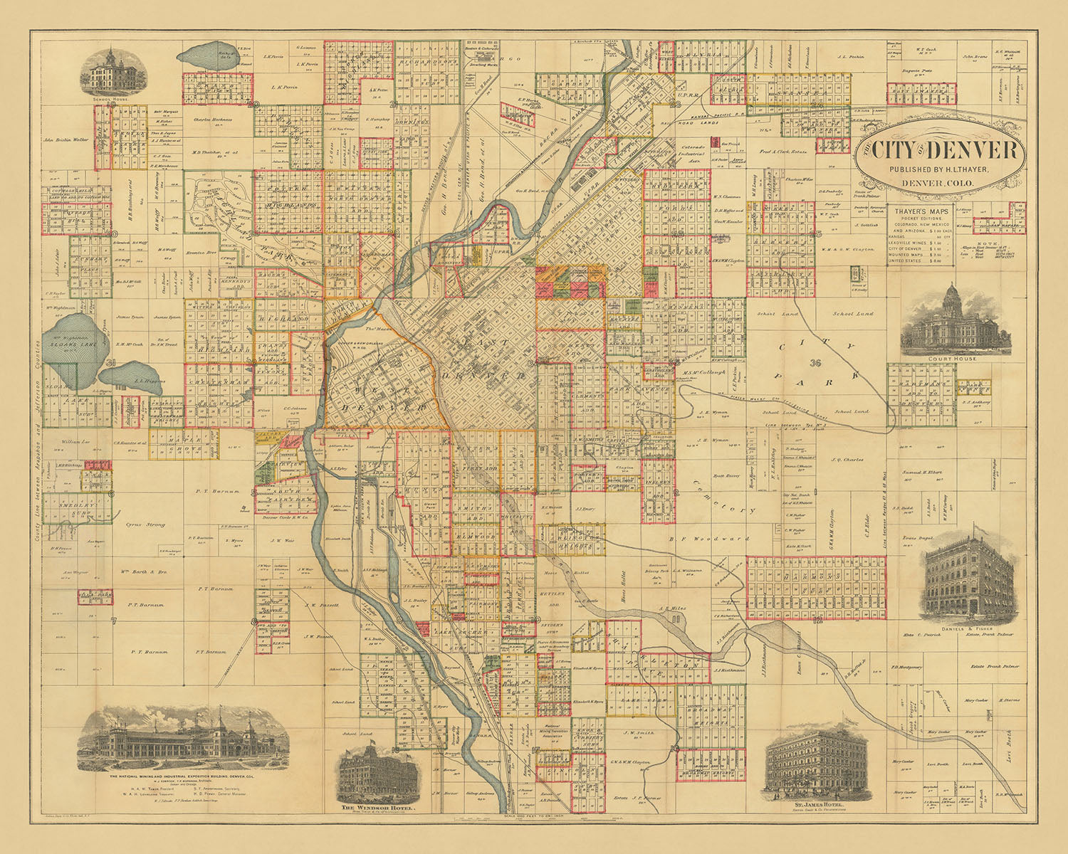
The "City of Denver" map, published by H.L. Thayer in 1883, is a captivating glimpse into the urban development of Denver during the late 19th century. This rare early map is centered on the Platte River, meticulously detailing the city's streets, landowners, and subdivisions. The inclusion of significant landmarks such as the Denver and New Orleans RR Company Lands and the Platte Water Company's Irrigating Canal highlights the infrastructural advancements of the era. This map not only serves as a navigational tool but also as a historical document, capturing the essence of Denver's growth and transformation.
One of the most striking features of this map is its detailed depiction of East Denver, showcasing the location of numerous buildings and the Denver and New Orleans Railroad Company Lands just across Cherry Creek in West Denver. The map provides a fascinating look at the early urban planning and land distribution, offering insights into the city's expansion and the pivotal role of the railroad in its development. The careful documentation of landowners' names and subdivisions adds a personal touch, connecting the viewer to the individuals who shaped Denver's early landscape.
The map is further embellished with six illustrated vignettes, each representing a significant landmark of the time. These include the National Mining and Industrial Exposition Building, which opened on August 1, 1882, the Windsor Hotel, St. James Hotel, Daniels & Fisher Building, Court House, and School House. These illustrations not only enhance the map's aesthetic appeal but also provide a visual narrative of Denver's architectural heritage. Each vignette serves as a window into the past, offering a glimpse of the city's prominent structures and their roles in the community.
City Park, labeled as Lot 36, is another notable feature on this map. The depiction of the Platte Water Company's Irrigating Canal flowing through the park highlights the importance of water management and green spaces in the city's planning. This early emphasis on creating a balanced urban environment with ample recreational areas reflects the foresight of Denver's planners and their commitment to enhancing the quality of life for its residents. The presence of large parks and natural features underscores the city's dedication to preserving its natural beauty amidst rapid urbanization.
H.L. Thayer's craftsmanship and attention to detail are evident throughout this map. His ability to capture the intricate layout of Denver, along with its significant landmarks and infrastructure, makes this map a valuable historical artifact. The "City of Denver" map is not just a tool for navigation but a rich tapestry of the city's history, offering a unique perspective on its growth and development. For collectors and history enthusiasts, this map is a treasure trove of information and a testament to Denver's vibrant past.
Streets and roads on this map
- Arapahoe Street
- Blake Street
- Broadway
- Champa Street
- Cherokee Street
- Cheyenne Place
- Colfax Avenue
- Curtis Street
- Delgany Street
- Eighteenth Street
- Eighth Avenue
- Eleventh Street
- Fifteenth Street
- Fourteenth Street
- Fox Street
- Grant Avenue
- Larimer Street
- Lawrence Street
- Lincoln Avenue
- Mariposa Street
- Market Street
- Platte Street
- Sixth Avenue
- Stout Street
- Tremont Place
- Twelfth Street
- Walnut Street
- Welton Street
- Wewatta Street
- Wynkoop Street
Notable Features & Landmarks
- Illustrations:
- The National Mining and Industrial Exposition Building
- Windsor Hotel
- St. James Hotel
- Daniels & Fisher Building
- Court House
-
School House
-
Landmarks:
- Platte River
-
Cherry Creek
-
Neighborhoods:
- East Denver
-
West Denver
-
Large Parks:
-
City Park (Lot 36)
-
Other Notable Features:
- Denver and New Orleans RR Company Lands
- Platte Water Company's Irrigating Canal
Historical and design context
- Name of the map: The City of Denver
- Publisher: H.L. Thayer
- Date of creation: 1883
- Type: City Street map
- Rare Early Map of Denver: Highly detailed map of the city of Denver.
- Map Center: Centered on the Platte River.
- Land Ownership: Includes the names of dozens of landowners, subdivisions, and other details.
- East Denver: Shows the location of a number of buildings and the Denver and New Orleans RR Company Lands just across Cherry Creek in west Denver.
- Platte Water Company: The Platte Water Company's Irrigating Canal is shown flowing through City Park (Lot 36) in the eastern part of the city.
- Illustrated Vignettes: Embellished with 6 illustrated vignettes:
- The National Mining and Industrial Exposition Building (opened August 1, 1882)
- Windsor Hotel
- St. James Hotel
- Daniels & Fisher Building
- Court House
- School House
- Historical Significance: Provides a snapshot of Denver's urban development and infrastructure in the late 19th century.
Please double check the images to make sure that a specific town or place is shown on this map. You can also get in touch and ask us to check the map for you.
This map looks great at every size, but I always recommend going for a larger size if you have space. That way you can easily make out all of the details.
This map looks amazing at sizes all the way up to 100in (250cm). If you are looking for a larger map, please get in touch.
Please note: the labels on this map are hard to read if you order a map that is 36in (90cm) or smaller. The map is still very attractive, but if you would like to read the map easily, please buy a larger size.
The model in the listing images is holding the 16x20in (40x50cm) version of this map.
The fifth listing image shows an example of my map personalisation service.
If you’re looking for something slightly different, check out my collection of the best old maps to see if something else catches your eye.
Please contact me to check if a certain location, landmark or feature is shown on this map.
This would make a wonderful birthday, Christmas, Father's Day, work leaving, anniversary or housewarming gift for someone from the areas covered by this map.
This map is available as a giclée print on acid free archival matte paper, or you can buy it framed. The frame is a nice, simple black frame that suits most aesthetics. Please get in touch if you'd like a different frame colour or material. My frames are glazed with super-clear museum-grade acrylic (perspex/acrylite), which is significantly less reflective than glass, safer, and will always arrive in perfect condition.
This map is also available as a float framed canvas, sometimes known as a shadow gap framed canvas or canvas floater. The map is printed on artist's cotton canvas and then stretched over a handmade box frame. We then "float" the canvas inside a wooden frame, which is available in a range of colours (black, dark brown, oak, antique gold and white). This is a wonderful way to present a map without glazing in front. See some examples of float framed canvas maps and explore the differences between my different finishes.
For something truly unique, this map is also available in "Unique 3D", our trademarked process that dramatically transforms the map so that it has a wonderful sense of depth. We combine the original map with detailed topography and elevation data, so that mountains and the terrain really "pop". For more info and examples of 3D maps, check my Unique 3D page.
Many of our maps and art prints are chosen as thoughtful gifts for homes, offices, studies and meaningful places.
Choose a framed option for the easiest ready-to-hang gift, or choose an unframed print if the recipient may prefer to select their own frame.
We make orders locally in 23 countries around the world, so gifts can often be produced close to the recipient. This helps them arrive faster, travel more safely, and avoid customs or import duty surprises.
- We can deliver directly to the recipient
- Framed pieces arrive ready to hang
- Unframed prints are carefully packed in a strong protective tube
- Almost every order is made locally, for faster, safer gifting
- 90-day returns give the recipient time to decide
If you are not sure what to choose, please contact us. We can help you pick the right map, size, finish or delivery option.
Most orders are made locally and delivered in around 2–3 working days, depending on the product, size and destination.
We print and frame maps and artwork in 23 countries around the world, so your order is usually made close to you or your recipient. That means faster delivery, less time in transit, and no customs or import duty surprises.
Personalised and customised pieces usually take an extra 1–2 working days, because we prepare your design and send it to you for approval before printing.
Very large framed orders can take a little longer, as they need extra care in production and delivery.
Every order is carefully packaged: unframed prints are sent in a strong protective tube, while framed pieces are securely packed with protective materials around the frame.
If you need your order by a particular date, please contact us before ordering. We’ll check the best production route and delivery option for your location.
Express delivery is available at checkout for most countries. Next-day delivery is available in the UK, US, Singapore and the UAE.
Your order is covered by our 90-day returns policy and 5-year guarantee.
My standard frame is a gallery style black ash hardwood frame. It is simple and quite modern looking. My standard frame is around 20mm (0.8in) wide.
I use super-clear acrylic (perspex/acrylite) for the frame glass. It's lighter and safer than glass - and it looks better, as the reflectivity is lower.
Six standard frame colours are available for free (black, dark brown, dark grey, oak, white and antique gold). Custom framing and mounting/matting is available if you're looking for something else.
Most maps, art and illustrations are also available as a framed canvas. We use matte (not shiny) cotton canvas, stretch it over a sustainably sourced box wood frame, and then 'float' the piece within a wood frame. The end result is quite beautiful, and there's no glazing to get in the way.
All frames are provided "ready to hang", with either a string or brackets on the back. Very large frames will have heavy duty hanging plates and/or a mounting baton. If you have any questions, please get in touch.
See some examples of my framed maps and framed canvas maps.
Alternatively, I can also supply old maps and artwork on canvas, foam board, cotton rag and other materials.
If you want to frame your map or artwork yourself, please read my size guide first.
My maps are extremely high quality reproductions of original maps.
I source original, rare maps from libraries, auction houses and private collections around the world, restore them at my London workshop, and then use specialist giclée inks and printers to create beautiful maps that look even better than the original.
My maps are printed on acid-free archival matte (not glossy) paper that feels very high quality and almost like card. In technical terms the paper weight/thickness is 10mil/200gsm. It's perfect for framing.
I print with Epson ultrachrome giclée UV fade resistant pigment inks - some of the best inks you can find.
I can also make maps on canvas, cotton rag and other exotic materials.
Learn more about The Unique Maps Co.
Map personalisation
If you're looking for the perfect anniversary or housewarming gift, I can personalise your map to make it truly unique. For example, I can add a short message, or highlight an important location, or add your family's coat of arms.
The options are almost infinite. Please see my map personalisation page for some wonderful examples of what's possible.
To order a personalised map, select "personalise your map" before adding it to your basket.
Get in touch if you're looking for more complex customisations and personalisations.
Map ageing
I have been asked hundreds of times over the years by customers if they could buy a map that looks even older.
Well, now you can, by selecting Aged before you add a map to your basket.
All the product photos you see on this page show the map in its Original form. This is what the map looks like today.
If you select Aged, I will age your map by hand, using a special and unique process developed through years of studying old maps, talking to researchers to understand the chemistry of aging paper, and of course... lots of practice!
If you're unsure, stick to the Original colour of the map. If you want something a bit darker and older looking, go for Aged.
If you are not happy with your order for any reason, contact me and I'll get it fixed ASAP, free of charge. Please see my returns and refund policy for more information.
I am very confident you will like your restored map or art print. I have been doing this since 1984. I'm a 5-star Etsy seller. I have sold tens of thousands of maps and art prints and have over 5,000 real 5-star reviews. My work has been featured in interior design magazines, on the BBC, and on the walls of dozens of 5-star hotels.
I use a unique process to restore maps and artwork that is massively time consuming and labour intensive. Hunting down the original maps and illustrations can take months. I use state of the art and eye-wateringly expensive technology to scan and restore them. As a result, I guarantee my maps and art prints are a cut above the rest. I stand by my products and will always make sure you're 100% happy with what you receive.
Almost all of my maps and art prints look amazing at large sizes (200cm, 6.5ft+) and I can frame and deliver them to you as well, via special oversized courier. Contact me to discuss your specific needs.
Or try searching for something!


