

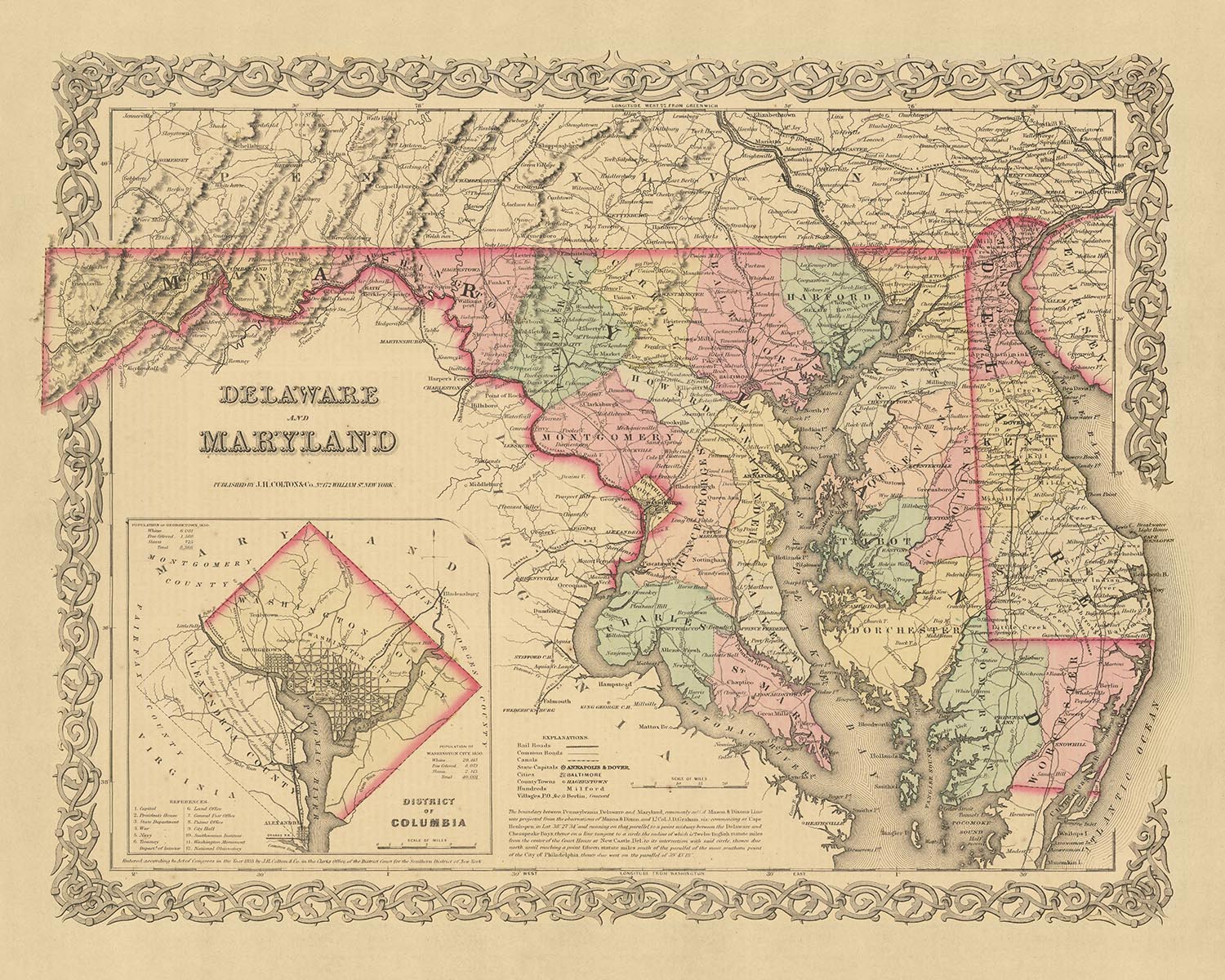


Rare Old Map of Delaware, Maryland & Washington D.C. by J.H. Colton, 1859: Wilmington, Baltimore, Annapolis, Dover
20% off 2 — 33% off 3
Add any two eligible items to your bag to receive 20% off. Add a third and it will be complimentary (equivalent to 33% off when purchasing three).
No code needed — the offer applies automatically at checkout.
Valid on all standard maps and fine art prints. You can mix and match any designs.
If you’d like to ship items to multiple addresses, please contact us before placing your order.
Custom and bespoke commissions are excluded.
Contact us if you have any questions
 Designed in London Made in the UK
Designed in London • Made in the UK
Designed in London Made in the UK
Designed in London • Made in the UK

Choose your size
Choose your finish


(More info)
Gift message & custom finish

If you want to add a gift message, or a finish (jigsaw, aluminium board, etc.) that is not available here, please request it in the "order note" when you check out.
Every order is custom made, so if you need the size adjusted slightly, or printed on an unusual material, just let us know. We've done thousands of custom orders over the years, so there's (almost) nothing we can't manage.
You can also contact us before you order, if you prefer!

- Made locally for fast, safe delivery
- No import duty or hidden fees
- Need advice? Message us on WhatsApp
Own a piece of history
7,000+ 5 star reviews


This exceptional piece is an old map of Delaware, Maryland, and Washington D.C., created by the renowned mapmaker J.H. Colton in 1859. Colton is widely recognized as one of the finest American mapmakers of his era, and his meticulous attention to detail is evident in this beautiful representation of the region. The map dates back to a time when the United States was in its infancy, and the region was still largely unexplored and undeveloped.
The map captures the region in its early stages of development, at a time when many of the settlements that we know today were yet to be founded. It is a testament to the rapid growth and transformation of the region, showcasing the five most notable settlements of the time: Wilmington, Baltimore, Annapolis, Dover, and Washington D.C. Each of these settlements played a crucial role in the history and development of the region, and their depiction in this map offers a fascinating glimpse into their origins.
It's important to note that many of the names and borders on this map may have changed over the last 150 years. The map serves as a snapshot of a bygone era, providing a unique perspective on the evolution of the region. It offers an intriguing contrast to the modern landscape, highlighting the changes that have occurred over time.
In the hands of J.H. Colton, this map becomes more than just a geographical representation; it's a work of art that captures the spirit of a time and place. The map is a testament to Colton's mastery and his ability to bring the past to life. It's a piece that will undoubtedly spark conversations and inspire a sense of wonder and curiosity about the history of the United States.
Whether you're a history enthusiast, a cartography aficionado, or simply someone who appreciates the beauty and craftsmanship of old maps, this piece is sure to be a cherished addition to your collection. It's not just a map; it's a piece of history, a work of art, and a conversation starter all rolled into one. This old map of Delaware, Maryland, and Washington D.C. by J.H. Colton is a treasure that offers a unique glimpse into the past, and a reminder of how far we've come.
Delaware
- Wilmington (1731) - Originally known as Fort Christina, it was the first Swedish settlement in North America. It is notable for its vibrant history and its role as a major player in the American industrial revolution.
- Dover (1683) - The capital of Delaware, known historically as the Court Town, it played a key role in the state's political and judicial affairs.
- New Castle (1651) - Originally named Fort Casimir by the Dutch, it was a strategic point of contention between the Dutch and the English.
- Lewes (1631) - Known as the first European settlement in Delaware, originally named Zwaanendael. It was a whaling and trading post.
- Smyrna (1716) - Originally called Duck Creek Cross Roads, it was a significant trading and shipping center due to its access to the Delaware Bay.
Maryland
- Baltimore (1729) - Known for its bustling port, it was a major shipbuilding and trading center.
- Annapolis (1649) - Originally called Providence, it served as the capital of Maryland and was a major center for the transatlantic slave trade.
- Frederick (1745) - Known for its rich history and as a gateway to the western part of the state.
- Hagerstown (1762) - Known as Jonathan Hager's Town, it was a strategic location during the Civil War.
- Cumberland (1787) - Known as the "Gateway to the West," it was a key transportation hub during the 19th century.
Washington D.C.
- Georgetown (1751) - Before becoming part of Washington D.C., it was a major port and commercial center.
- Alexandria (1749) - Known for its rich history and well-preserved 18th and 19th-century architecture.
- Foggy Bottom (1763) - One of the oldest late 18th and 19th-century neighborhoods in D.C., known for its historic buildings.
- Capitol Hill (1799) - Home to the U.S. Capitol Building, it's one of the city's oldest residential neighborhoods.
- Dupont Circle (1870s) - Known for its iconic traffic circle and historic homes, it's one of D.C.'s trendiest neighborhoods.
Native American Tribes
- Nanticoke Tribe - Indigenous people of Delaware and Maryland, known for their agricultural practices.
- Piscataway Tribe - Native tribe in Maryland, known for their trade networks.
- Powhatan Confederacy - A group of indigenous tribes in the Virginia and Maryland area.
Notable Natural Features
- Chesapeake Bay - The largest estuary in the U.S., offering a variety of recreational activities.
- Appalachian Mountains - The range extends into Maryland, providing scenic beauty and outdoor activities.
- Potomac River - A major waterway in D.C., offering boating, fishing, and scenic views.
Historical Events (1810-1859)
- War of 1812 - Significant battles took place in Baltimore and Washington D.C., including the burning of the White House.
- Baltimore Riots (1812) - Violent demonstrations by anti-war Federalists.
- Chesapeake and Ohio Canal (1828-1850) - The construction of this canal had a significant impact on transportation and trade in the region.
- The Compromise of 1850 - A series of laws passed to maintain the balance of power between slave and free states, had significant implications for the region.
Please double check the images to make sure that a specific town or place is shown on this map. You can also get in touch and ask us to check the map for you.
This map looks great at all sizes, but it looks even better when printed large.
I can create beautiful, large prints of this map up to 70in (178cm). Please get in touch if you're looking for larger, customised or different framing options.
The model in the listing images is holding the 16x20in (40.5x51cm) version of this map.
The fifth listing image shows an example of my map personalisation service.
If you’re looking for something slightly different, check out my main collection of USA and North America maps.
Please contact me to check if a certain location, landmark or feature is shown on this map.
This would make a wonderful birthday, Christmas, Father's Day, work leaving, anniversary or housewarming gift for someone from the areas covered by this map.
This map is available as a giclée print on acid free archival matte paper, or you can buy it framed. The frame is a nice, simple black frame that suits most aesthetics. Please get in touch if you'd like a different frame colour or material. My frames are glazed with super-clear museum-grade acrylic (perspex/acrylite), which is significantly less reflective than glass, safer, and will always arrive in perfect condition.
This map is also available as a float framed canvas, sometimes known as a shadow gap framed canvas or canvas floater. The map is printed on artist's cotton canvas and then stretched over a handmade box frame. We then "float" the canvas inside a wooden frame, which is available in a range of colours (black, dark brown, oak, antique gold and white). This is a wonderful way to present a map without glazing in front. See some examples of float framed canvas maps and explore the differences between my different finishes.
For something truly unique, this map is also available in "Unique 3D", our trademarked process that dramatically transforms the map so that it has a wonderful sense of depth. We combine the original map with detailed topography and elevation data, so that mountains and the terrain really "pop". For more info and examples of 3D maps, check my Unique 3D page.
Many of our maps and art prints are chosen as thoughtful gifts for homes, offices, studies and meaningful places.
Choose a framed option for the easiest ready-to-hang gift, or choose an unframed print if the recipient may prefer to select their own frame.
We make orders locally in 23 countries around the world, so gifts can often be produced close to the recipient. This helps them arrive faster, travel more safely, and avoid customs or import duty surprises.
- We can deliver directly to the recipient
- Framed pieces arrive ready to hang
- Unframed prints are carefully packed in a strong protective tube
- Almost every order is made locally, for faster, safer gifting
- 90-day returns give the recipient time to decide
If you are not sure what to choose, please contact us. We can help you pick the right map, size, finish or delivery option.
Most orders are made locally and delivered in around 2–3 working days, depending on the product, size and destination.
We print and frame maps and artwork in 23 countries around the world, so your order is usually made close to you or your recipient. That means faster delivery, less time in transit, and no customs or import duty surprises.
Personalised and customised pieces usually take an extra 1–2 working days, because we prepare your design and send it to you for approval before printing.
Very large framed orders can take a little longer, as they need extra care in production and delivery.
Every order is carefully packaged: unframed prints are sent in a strong protective tube, while framed pieces are securely packed with protective materials around the frame.
If you need your order by a particular date, please contact us before ordering. We’ll check the best production route and delivery option for your location.
Express delivery is available at checkout for most countries. Next-day delivery is available in the UK, US, Singapore and the UAE.
Your order is covered by our 90-day returns policy and 10-year guarantee.
Our standard frame is a gallery-style black ash hardwood frame, with a simple, modern look. It is approximately 20mm (0.8in) wide. You can also view some lovely customer photos of framed maps and art.
We use super-clear acrylic glazing, also known as Perspex or Acrylite, instead of traditional glass. It is lighter, safer, and has lower reflectivity, giving the artwork a clearer, cleaner appearance.
Six standard frame colours are available at no extra cost: black, dark brown, dark grey, oak, white, and antique gold. Custom framing and mounting/matting is also available for customers looking for something more specific.
Most maps, art prints, and illustrations are also available as a framed canvas. We use matte cotton canvas, stretch it over a sustainably sourced wooden box frame, and then float the piece within a wooden outer frame. The finished result is beautifully presented, with no glazing between you and the artwork.
All frames are supplied ready to hang, with either string or brackets fitted to the back. Very large frames will include heavy-duty hanging plates and/or a mounting baton. If you have any questions, please get in touch.
We can also supply old maps and artwork on canvas, foam board, cotton rag, and other materials.
If you would prefer to frame your map or artwork yourself, please read our size guide before ordering.
My maps are extremely high quality reproductions of original maps.
I source original, rare maps from libraries, auction houses and private collections around the world, restore them at my London workshop, and then use specialist giclée inks and printers to create beautiful maps that look even better than the original.
My maps are printed on acid-free archival matte (not glossy) paper that feels very high quality and almost like card. In technical terms the paper weight/thickness is 10mil/200gsm. It's perfect for framing.
I print with Epson ultrachrome giclée UV fade resistant pigment inks - some of the best inks you can find.
I can also make maps on canvas, cotton rag and other exotic materials.
Learn more about The Unique Maps Co.
Map personalisation
If you're looking for the perfect anniversary or housewarming gift, I can personalise your map to make it truly unique. For example, I can add a short message, or highlight an important location, or add your family's coat of arms.
The options are almost infinite. Please see my map personalisation page for some wonderful examples of what's possible.
To order a personalised map, select "personalise your map" before adding it to your basket.
Get in touch if you're looking for more complex customisations and personalisations.
Map ageing
I have been asked hundreds of times over the years by customers if they could buy a map that looks even older.
Well, now you can, by selecting Aged before you add a map to your basket.
All the product photos you see on this page show the map in its Original form. This is what the map looks like today.
If you select Aged, I will age your map by hand, using a special and unique process developed through years of studying old maps, talking to researchers to understand the chemistry of aging paper, and of course... lots of practice!
If you're unsure, stick to the Original colour of the map. If you want something a bit darker and older looking, go for Aged.
If you are not happy with your order for any reason, contact me and I'll get it fixed ASAP, free of charge. Please see my returns and refund policy for more information.
I am very confident you will like your restored map or art print. I have been doing this since 1984. I'm a 5-star Etsy seller. I have sold tens of thousands of maps and art prints and have over 5,000 real 5-star reviews. My work has been featured in interior design magazines, on the BBC, and on the walls of dozens of 5-star hotels.
I use a unique process to restore maps and artwork that is massively time consuming and labour intensive. Hunting down the original maps and illustrations can take months. I use state of the art and eye-wateringly expensive technology to scan and restore them. As a result, I guarantee my maps and art prints are a cut above the rest. I stand by my products and will always make sure you're 100% happy with what you receive.
Almost all of my maps and art prints look amazing at large sizes (200cm, 6.5ft+) and I can frame and deliver them to you as well, via special oversized courier. Contact me to discuss your specific needs.
Or try searching for something!


