


Rare Old Map of California Wine Regions, 1935: Wine-Making, Vineyards, Sonoma, Napa Valley, Vignettes
The Collector’s Offer
Choose two eligible works and receive 20% off both. Choose three and the lowest-priced one is complimentary, a maximum saving of 33%.
Mix and match eligible standard maps and fine-art prints. No code is required; the offer is applied automatically at checkout.
Standard made-to-order configurations are included. Bespoke sizes, personalised designs and commissioned work are excluded.
Need delivery to different addresses? Contact us before ordering.The Collector’s Offer
Choose two eligible works and receive 20% off both. Choose three and the lowest-priced one is complimentary, a maximum saving of 33%.
Mix and match eligible standard maps and fine-art prints. No code is required; the offer is applied automatically at checkout.
Standard made-to-order configurations are included. Bespoke sizes, personalised designs and commissioned work are excluded.
Need delivery to different addresses? Contact us before ordering. Designed in London Made in the UK
Designed in London • Made in the UK
Designed in London Made in the UK
Designed in London • Made in the UK

Restored from the original 1935 map and printed to museum-grade archival standards. Read the story behind this map
Choose your size
Choose your finish


(More info)
Gift message & custom finish

If you want to add a gift message, or a finish (jigsaw, aluminium board, etc.) that is not available here, please request it in the "order note" when you check out.
Every order is custom made, so if you need the size adjusted slightly, or printed on an unusual material, just let us know. We've done thousands of custom orders over the years, so there's (almost) nothing we can't manage.
You can also contact us before you order, if you prefer!

- Made locally for fast, safe delivery
- No import duty or hidden fees
- Need advice? Call us or message on WhatsApp
Own a piece of history
8,000+ five-star reviews


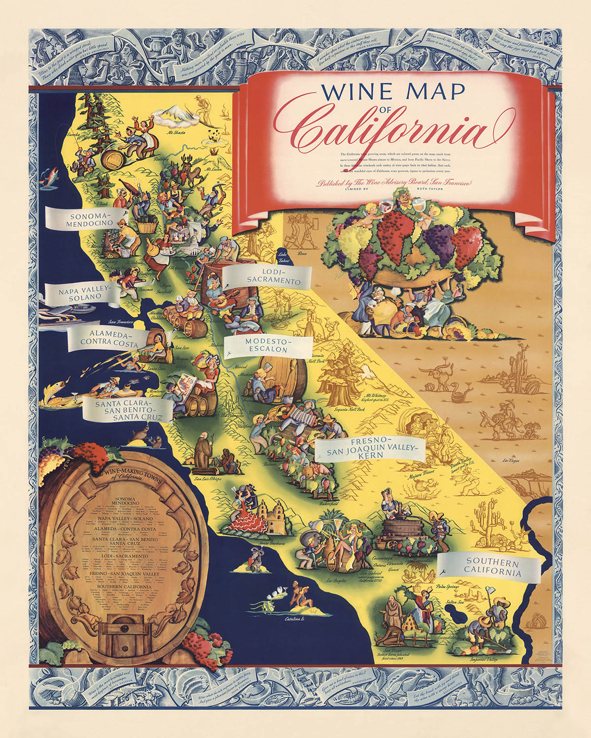
The "Wine Map of California," crafted by the renowned Ruth Taylor White in 1935, is a vibrant and whimsical pictorial representation of...
Continue readingThe "Wine Map of California," crafted by the renowned Ruth Taylor White in 1935, is a vibrant and whimsical pictorial representation of California's rich wine-making heritage. This thematic map highlights the key wine-producing regions of the state, including Sonoma-Mendocino, Napa Valley-Solano, and Fresno-San Joaquin Valley-Kern, among others. Each region is illustrated with colorful vignettes that depict the lively and diverse activities associated with wine production, making the map not only informative but also visually captivating.
This map serves as an infographic, presenting detailed information about California's wine industry in an engaging and illustrative manner. The decorative border, adorned with quotes about wine, adds a touch of elegance and literary charm, while the inset at the lower left lists the prominent wine-making towns, providing a comprehensive overview of the state's viticultural landscape. The use of vibrant colors and playful illustrations makes the data accessible and enjoyable, appealing to both wine enthusiasts and map collectors alike.
Ruth Taylor White's distinctive mapmaking style is evident in this piece, characterized by its colorful and cartoonish depictions. Known for her pictorial maps, White's work often combines artistic flair with geographical accuracy, creating maps that are both educational and aesthetically pleasing. This particular map, created shortly after the end of Prohibition, captures the resurgence of the wine industry in California, reflecting the cultural and economic significance of wine production during that era.
The map's design and style offer a glimpse into the historical context of the 1930s, showcasing the revival of the wine industry after the restrictive Prohibition years. The illustrations not only highlight the geographical regions but also depict the cultural activities and traditions associated with wine-making, providing a rich tapestry of information and visual delight. The map's playful yet informative approach makes it a valuable piece for understanding the historical and cultural landscape of California's wine industry.
Overall, the "Wine Map of California" by Ruth Taylor White is a remarkable blend of art and information, capturing the essence of California's wine-making regions with charm and precision. Its historical significance, combined with White's unique artistic style, makes it a treasured addition to any collection, offering both a visual feast and a wealth of knowledge about one of the state's most celebrated industries.
Places on this map
- Wine-making regions:
- Sonoma - Mendocino
- Napa Valley - Solano
- Alameda - Contra Costa
- Lodi - Sacramento
- Santa Clara - San Benito - Santa Cruz
- Modesto - Escalon
- Fresno - San Joaquin Valley - Kern
- Southern California
- Geographical features:
- San Francisco Bay
- Mt. Shasta
- Sierra Nevada
- Los Angeles
- San Diego
- Catalina Island
- Towns and cities:
- San Francisco
- Sacramento
- Modesto
- Fresno
- Los Angeles
- San Diego
- Santa Cruz
- Napa
- Sonoma
Notable Features & Landmarks
- Wine-making regions:
- Sonoma - Mendocino
- Napa Valley - Solano
- Alameda - Contra Costa
- Lodi - Sacramento
- Santa Clara - San Benito - Santa Cruz
- Modesto - Escalon
- Fresno - San Joaquin Valley - Kern
- Southern California
- Decorative inset:
- Lists "The Wine-Making Towns of California."
- Decorative border:
- Features quotes about wine.
- Colored vignettes:
- Illustrations of wine-making activities and characters in each wine-growing region.
- Geographical landmarks:
- Mountains, rivers, and other notable geographical features of California.
- Cultural elements:
- Depictions of people engaged in wine-making and related activities.
Historical and design context
- Name of the map: Wine Map of California
- Creation date: 1935
- Mapmaker/Publisher: Ruth Taylor White
- Ruth Taylor White was known for her colorful and whimsical pictorial maps.
- Type of map: Infographic, Thematic, and Pictorial map
- Topics and themes:
- Wine Making: The map highlights the wine-making regions and communities in California.
- Wine Quotes: Decorative border featuring quotes about wine.
- Design/style:
- Colorful and Decorative: Features colored vignettes in wine-growing regions and a decorative border.
- Pictorial Elements: Illustrative and cartoonish depictions of wine-making activities and regions.
- Inset: Decorative inset at the lower left listing "The Wine-Making Towns of California."
- Historical significance:
- Prohibition Era Context: Created shortly after the end of Prohibition in the United States (1920-1933), marking a resurgence in the wine industry.
- Cultural Representation: Reflects the cultural and economic importance of wine production in California during the early 20th century.
Please double check the images to make sure that a specific town or place is shown on this map. You can also get in touch and ask us to check the map for you.
This map looks great at every size, but I always recommend going for a larger size if you have space. That way you can easily make out all of the details.
This map looks amazing at sizes all the way up to 100in (250cm). If you are looking for a larger map, please get in touch.
The model in the listing images is holding the 16x20in (40x50cm) version of this map.
The fifth listing image shows an example of my map personalisation service.
If you’re looking for something slightly different, check out my collection of the best old maps to see if something else catches your eye.
Please contact me to check if a certain location, landmark or feature is shown on this map.
This would make a wonderful birthday, Christmas, Father's Day, work leaving, anniversary or housewarming gift for someone from the areas covered by this map.
This map is available as a giclée print on acid free archival matte paper, or you can buy it framed. The frame is a nice, simple black frame that suits most aesthetics. Please get in touch if you'd like a different frame colour or material. My frames are glazed with super-clear museum-grade acrylic (perspex/acrylite), which is significantly less reflective than glass, safer, and will always arrive in perfect condition.
This map is also available as a float framed canvas, sometimes known as a shadow gap framed canvas or canvas floater. The map is printed on artist's cotton canvas and then stretched over a handmade box frame. We then "float" the canvas inside a wooden frame, which is available in a range of colours (black, dark brown, oak, antique gold and white). This is a wonderful way to present a map without glazing in front. See some examples of float framed canvas maps and explore the differences between my different finishes.
For something truly unique, this map is also available in "Unique 3D", our trademarked process that dramatically transforms the map so that it has a wonderful sense of depth. We combine the original map with detailed topography and elevation data, so that mountains and the terrain really "pop". For more info and examples of 3D maps, check my Unique 3D page.
The "Wine Map of California," crafted by the renowned Ruth Taylor White in 1935, is a vibrant and whimsical pictorial representation of California's rich wine-making heritage. This thematic map highlights the key wine-producing regions of the state, including Sonoma-Mendocino, Napa Valley-Solano, and Fresno-San Joaquin Valley-Kern, among others. Each region is illustrated with colorful vignettes that depict the lively and diverse activities associated with wine production, making the map not only informative but also visually captivating.
This map serves as an infographic, presenting detailed information about California's wine industry in an engaging and illustrative manner. The decorative border, adorned with quotes about wine, adds a touch of elegance and literary charm, while the inset at the lower left lists the prominent wine-making towns, providing a comprehensive overview of the state's viticultural landscape. The use of vibrant colors and playful illustrations makes the data accessible and enjoyable, appealing to both wine enthusiasts and map collectors alike.
Ruth Taylor White's distinctive mapmaking style is evident in this piece, characterized by its colorful and cartoonish depictions. Known for her pictorial maps, White's work often combines artistic flair with geographical accuracy, creating maps that are both educational and aesthetically pleasing. This particular map, created shortly after the end of Prohibition, captures the resurgence of the wine industry in California, reflecting the cultural and economic significance of wine production during that era.
The map's design and style offer a glimpse into the historical context of the 1930s, showcasing the revival of the wine industry after the restrictive Prohibition years. The illustrations not only highlight the geographical regions but also depict the cultural activities and traditions associated with wine-making, providing a rich tapestry of information and visual delight. The map's playful yet informative approach makes it a valuable piece for understanding the historical and cultural landscape of California's wine industry.
Overall, the "Wine Map of California" by Ruth Taylor White is a remarkable blend of art and information, capturing the essence of California's wine-making regions with charm and precision. Its historical significance, combined with White's unique artistic style, makes it a treasured addition to any collection, offering both a visual feast and a wealth of knowledge about one of the state's most celebrated industries.
Places on this map
- Wine-making regions:
- Sonoma - Mendocino
- Napa Valley - Solano
- Alameda - Contra Costa
- Lodi - Sacramento
- Santa Clara - San Benito - Santa Cruz
- Modesto - Escalon
- Fresno - San Joaquin Valley - Kern
- Southern California
- Geographical features:
- San Francisco Bay
- Mt. Shasta
- Sierra Nevada
- Los Angeles
- San Diego
- Catalina Island
- Towns and cities:
- San Francisco
- Sacramento
- Modesto
- Fresno
- Los Angeles
- San Diego
- Santa Cruz
- Napa
- Sonoma
Notable Features & Landmarks
- Wine-making regions:
- Sonoma - Mendocino
- Napa Valley - Solano
- Alameda - Contra Costa
- Lodi - Sacramento
- Santa Clara - San Benito - Santa Cruz
- Modesto - Escalon
- Fresno - San Joaquin Valley - Kern
- Southern California
- Decorative inset:
- Lists "The Wine-Making Towns of California."
- Decorative border:
- Features quotes about wine.
- Colored vignettes:
- Illustrations of wine-making activities and characters in each wine-growing region.
- Geographical landmarks:
- Mountains, rivers, and other notable geographical features of California.
- Cultural elements:
- Depictions of people engaged in wine-making and related activities.
Historical and design context
- Name of the map: Wine Map of California
- Creation date: 1935
- Mapmaker/Publisher: Ruth Taylor White
- Ruth Taylor White was known for her colorful and whimsical pictorial maps.
- Type of map: Infographic, Thematic, and Pictorial map
- Topics and themes:
- Wine Making: The map highlights the wine-making regions and communities in California.
- Wine Quotes: Decorative border featuring quotes about wine.
- Design/style:
- Colorful and Decorative: Features colored vignettes in wine-growing regions and a decorative border.
- Pictorial Elements: Illustrative and cartoonish depictions of wine-making activities and regions.
- Inset: Decorative inset at the lower left listing "The Wine-Making Towns of California."
- Historical significance:
- Prohibition Era Context: Created shortly after the end of Prohibition in the United States (1920-1933), marking a resurgence in the wine industry.
- Cultural Representation: Reflects the cultural and economic importance of wine production in California during the early 20th century.
Please double check the images to make sure that a specific town or place is shown on this map. You can also get in touch and ask us to check the map for you.
This map looks great at every size, but I always recommend going for a larger size if you have space. That way you can easily make out all of the details.
This map looks amazing at sizes all the way up to 100in (250cm). If you are looking for a larger map, please get in touch.
The model in the listing images is holding the 16x20in (40x50cm) version of this map.
The fifth listing image shows an example of my map personalisation service.
If you’re looking for something slightly different, check out my collection of the best old maps to see if something else catches your eye.
Please contact me to check if a certain location, landmark or feature is shown on this map.
This would make a wonderful birthday, Christmas, Father's Day, work leaving, anniversary or housewarming gift for someone from the areas covered by this map.
This map is available as a giclée print on acid free archival matte paper, or you can buy it framed. The frame is a nice, simple black frame that suits most aesthetics. Please get in touch if you'd like a different frame colour or material. My frames are glazed with super-clear museum-grade acrylic (perspex/acrylite), which is significantly less reflective than glass, safer, and will always arrive in perfect condition.
This map is also available as a float framed canvas, sometimes known as a shadow gap framed canvas or canvas floater. The map is printed on artist's cotton canvas and then stretched over a handmade box frame. We then "float" the canvas inside a wooden frame, which is available in a range of colours (black, dark brown, oak, antique gold and white). This is a wonderful way to present a map without glazing in front. See some examples of float framed canvas maps and explore the differences between my different finishes.
For something truly unique, this map is also available in "Unique 3D", our trademarked process that dramatically transforms the map so that it has a wonderful sense of depth. We combine the original map with detailed topography and elevation data, so that mountains and the terrain really "pop". For more info and examples of 3D maps, check my Unique 3D page.
Many of our maps and art prints are chosen as thoughtful gifts for homes, offices, studies and meaningful places.
Choose a framed option for the easiest ready-to-hang gift, or choose an unframed print if the recipient may prefer to select their own frame.
We make orders locally in 23 countries around the world, so gifts can often be produced close to the recipient. This helps them arrive faster, travel more safely, and avoid customs or import duty surprises.
- We can deliver directly to the recipient
- Framed pieces arrive ready to hang
- Unframed prints are carefully packed in a strong protective tube
- Almost every order is made locally, for faster, safer gifting
- 90-day returns give the recipient time to decide
If you are not sure what to choose, please contact us. We can help you pick the right map, size, finish or delivery option.
Most orders are made locally and delivered in around 2–3 working days, depending on the product, size and destination.
We print and frame maps and artwork in 23 countries around the world, so your order is usually made close to you or your recipient. That means faster delivery, less time in transit, and no customs or import duty surprises.
Personalised and customised pieces usually take an extra 1–2 working days, because we prepare your design and send it to you for approval before printing.
Very large framed orders can take a little longer, as they need extra care in production and delivery.
Every order is carefully packaged: unframed prints are sent in a strong protective tube, while framed pieces are securely packed with protective materials around the frame.
If you need your order by a particular date, please contact us before ordering. We’ll check the best production route and delivery option for your location.
Express delivery is available at checkout for most countries. Next-day delivery is available in the UK, US, Singapore and the UAE.
Your order is covered by our 90-day returns policy and 10-year guarantee.
Our standard frame is a gallery-style black ash hardwood frame, with a simple, modern look. It is approximately 20mm (0.8in) wide. You can also view some lovely customer photos of framed maps and art.
We use super-clear acrylic glazing, also known as Perspex or Acrylite, instead of traditional glass. It is lighter, safer, and has lower reflectivity, giving the artwork a clearer, cleaner appearance.
Six standard frame colours are available at no extra cost: black, dark brown, dark grey, oak, white, and antique gold. Custom framing and mounting/matting is also available for customers looking for something more specific.
Most maps, art prints, and illustrations are also available as a framed canvas. We use matte cotton canvas, stretch it over a sustainably sourced wooden box frame, and then float the piece within a wooden outer frame. The finished result is beautifully presented, with no glazing between you and the artwork.
All frames are supplied ready to hang, with either string or brackets fitted to the back. Very large frames will include heavy-duty hanging plates and/or a mounting baton. If you have any questions, please get in touch.
We can also supply old maps and artwork on canvas, foam board, cotton rag, and other materials.
If you would prefer to frame your map or artwork yourself, please read our size guide before ordering.
My maps are extremely high quality reproductions of original maps.
I source original, rare maps from libraries, auction houses and private collections around the world, restore them at my London workshop, and then use specialist giclée inks and printers to create beautiful maps that look even better than the original.
My maps are printed on acid-free archival matte (not glossy) paper that feels very high quality and almost like card. In technical terms the paper weight/thickness is 10mil/200gsm. It's perfect for framing.
I print with Epson ultrachrome giclée UV fade resistant pigment inks - some of the best inks you can find.
I can also make maps on canvas, cotton rag and other exotic materials.
Learn more about The Unique Maps Co.
Map personalisation
If you're looking for the perfect anniversary or housewarming gift, I can personalise your map to make it truly unique. For example, I can add a short message, or highlight an important location, or add your family's coat of arms.
The options are almost infinite. Please see my map personalisation page for some wonderful examples of what's possible.
To order a personalised map, select "personalise your map" before adding it to your basket.
Get in touch if you're looking for more complex customisations and personalisations.
Map ageing
I have been asked hundreds of times over the years by customers if they could buy a map that looks even older.
Well, now you can, by selecting Aged before you add a map to your basket.
All the product photos you see on this page show the map in its Original form. This is what the map looks like today.
If you select Aged, I will age your map by hand, using a special and unique process developed through years of studying old maps, talking to researchers to understand the chemistry of aging paper, and of course... lots of practice!
If you're unsure, stick to the Original colour of the map. If you want something a bit darker and older looking, go for Aged.
If you are not happy with your order for any reason, contact me and I'll get it fixed ASAP, free of charge. Please see my returns and refund policy for more information.
I am very confident you will like your restored map or art print. I have been doing this since 1984. I'm a 5-star Etsy seller. I have sold tens of thousands of maps and art prints and have over 5,000 real 5-star reviews. My work has been featured in interior design magazines, on the BBC, and on the walls of dozens of 5-star hotels.
I use a unique process to restore maps and artwork that is massively time consuming and labour intensive. Hunting down the original maps and illustrations can take months. I use state of the art and eye-wateringly expensive technology to scan and restore them. As a result, I guarantee my maps and art prints are a cut above the rest. I stand by my products and will always make sure you're 100% happy with what you receive.
Almost all of my maps and art prints look amazing at large sizes (200cm, 6.5ft+) and I can frame and deliver them to you as well, via special oversized courier. Contact me to discuss your specific needs.
Or try searching for something!


