


Rare Old Map of California & Nevada by J.H. Colton, 1875: San Francisco, Sacramento, Los Angeles, Carson City, and Virginia City
20% off 2 — 33% off 3
Add any two eligible items to your bag to receive 20% off. Add a third and it will be complimentary (equivalent to 33% off when purchasing three).
No code needed — the offer applies automatically at checkout.
Valid on all standard maps and fine art prints. You can mix and match any designs.
If you’d like to ship items to multiple addresses, please contact us before placing your order.
Custom and bespoke commissions are excluded.
Contact us if you have any questions
 Designed in London Made in the UK
Designed in London • Made in the UK
Designed in London Made in the UK
Designed in London • Made in the UK

Restored from the original 1875 map and printed to museum-grade archival standards. Read the story behind this map
Choose your size
Choose your finish


(More info)
Gift message & custom finish

If you want to add a gift message, or a finish (jigsaw, aluminium board, etc.) that is not available here, please request it in the "order note" when you check out.
Every order is custom made, so if you need the size adjusted slightly, or printed on an unusual material, just let us know. We've done thousands of custom orders over the years, so there's (almost) nothing we can't manage.
You can also contact us before you order, if you prefer!

- Made locally for fast, safe delivery
- No import duty or hidden fees
- Need advice? Call us or message on WhatsApp
Own a piece of history
8,000+ five-star reviews


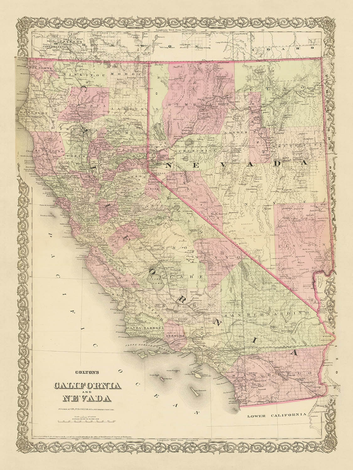
Step back in time with this exquisite map of California and Nevada from 1875, masterfully crafted by the renowned American mapmaker, J.H....
Continue readingStep back in time with this exquisite map of California and Nevada from 1875, masterfully crafted by the renowned American mapmaker, J.H. Colton. This piece is not just a map, but a window into the early history of the United States, offering a unique perspective on the evolution of these two significant states. The map, which is a testament to Colton's exceptional skill and precision, captures the landscape as it was in the late 19th century, a time when many of the settlements we know today were yet to be founded.
The map provides a fascinating glimpse into the past, revealing how much the names and borders have changed over the past 150 years. The settlements of San Francisco, Sacramento, Los Angeles, Carson City, and Virginia City are prominently featured, standing as testament to the enduring spirit of exploration and expansion that characterized this era. This map is a must-have for history enthusiasts, map collectors, and anyone interested in the intricate tapestry of America's past.
This map is a remarkable artifact from a pivotal time in American history. The 1870s were a period of rapid growth and change in the American West. The Gold Rush had brought a flood of settlers to California, and Nevada was experiencing its own silver boom. This map captures this dynamic period, with its detailed renderings of the towns and cities that were springing up amidst the wild, untamed landscape. It's a tangible connection to an era that shaped the course of American history, and a unique piece of art that will add a touch of elegance and intrigue to any space.
This map is not only a valuable historical document but also a work of art. The fine detailing, the delicate coloration, and the careful representation of topographical features all speak to the skill and artistry of J.H. Colton. This is a rare opportunity to own a piece of history, meticulously preserved and beautifully presented. Whether you're a seasoned collector or a newcomer to the world of antique maps, this piece is sure to captivate and inspire.
California Settlements
- San Francisco (1776): Originally known as Yerba Buena, San Francisco was a key hub during the Gold Rush and remains a major global city today.
- Sacramento (1848): Founded during the Gold Rush, Sacramento became the state capital in 1854.
- Los Angeles (1781): Originally El Pueblo de Nuestra Señora la Reina de los Ángeles, it's now the largest city in California.
- San Diego (1769): The first Spanish mission in California, it's now a major city and naval base.
- San Jose (1777): Known as El Pueblo de San José de Guadalupe, it's now the heart of Silicon Valley.
- Monterey (1770): Once the capital of Alta California under both Spain and Mexico.
- Santa Barbara (1786): Home to the Presidio of Santa Barbara, a Spanish military installation and mission.
- Sonoma (1835): The site of the Bear Flag Revolt, which led to California becoming part of the U.S.
- Fresno (1872): Founded by the Central Pacific Railroad Company.
- Stockton (1849): Known as Mudville, it was a major supply center during the Gold Rush.
Nevada Settlements
- Carson City (1858): Named after the famous frontiersman Kit Carson, it's the state capital.
- Virginia City (1859): The discovery of the Comstock Lode here triggered a silver rush.
- Reno (1868): Known as "The Biggest Little City in the World," it was a key railroad town.
- Elko (1869): Established as a railroad town along the Central Pacific Railroad.
- Dayton (1849): Known as Nevada's first settlement, it was a key supply center for gold miners.
- Genoa (1851): Nevada's first permanent non-native settlement.
- Eureka (1864): The "Pittsburgh of the West" during the silver boom.
- Winnemucca (1863): A key transportation and trading hub for settlers.
- Wells (1869): Established by Central Pacific Railroad as a watering station for steam engines.
- Silver City (1859): A mining boomtown after silver was discovered in the Comstock Lode.
Native American Tribes
- Shoshone: Occupied parts of eastern Nevada.
- Paiute: Lived in the northern and central parts of Nevada and eastern California.
- Washoe: Inhabited the Lake Tahoe region.
- Miwok: Occupied areas in central California.
- Yokuts: Lived in the San Joaquin Valley in California.
Notable Natural Features
- Sierra Nevada: A major mountain range, home to Yosemite National Park and Lake Tahoe.
- Death Valley: The lowest, driest, and hottest area in North America.
- Mojave Desert: The driest desert in North America.
- Colorado River: Known for its dramatic canyons, including the Grand Canyon.
- San Francisco Bay: One of the world's largest natural harbors.
Historical Events
- California Gold Rush (1848-1855): This massive gold strike led to a wave of immigration to California.
- Comstock Lode Discovery (1859): The first major silver deposit discovery in the United States, located under what is now Virginia City, Nevada.
- Admission of California (1850) and Nevada (1864) to the Union.
- Transcontinental Railroad Completion (1869): The railroad's western terminus was in Sacramento.
Please double check the images to make sure that a specific town or place is shown on this map. You can also get in touch and ask us to check the map for you.
This map looks great at all sizes: 12x16in (30.5x41cm), 18x24in (45.5x61cm), 16x20in (40.5x51cm), 24x36in (61x91.5cm), 30x40in (76x101.5cm), 37x50in (94x127cm), 45x60in (114x152.5cm) and 52x70in (132x178cm), but it looks even better when printed large.
I can create beautiful, large prints of this map up to 100in (254cm). Please get in touch if you're looking for larger, customised or different framing options.
The model in the listing images is holding the 18x24in (45.5x61cm) version of this map.
The fifth listing image shows an example of my map personalisation service.
The labels on this map are very small at 12x16in (30.5x41cm). The map is still very attractive, but you may struggle to read the smallest letters. Please buy a larger map if it's important to be able to read the map easily.
If you’re looking for something slightly different, check out my main collection of USA and North America maps.
Please contact me to check if a certain location, landmark or feature is shown on this map.
This would make a wonderful birthday, Christmas, Father's Day, work leaving, anniversary or housewarming gift for someone from the areas covered by this map.
This map is available as a giclée print on acid free archival matte paper, or you can buy it framed. The frame is a nice, simple black frame that suits most aesthetics. Please get in touch if you'd like a different frame colour or material. My frames are glazed with super-clear museum-grade acrylic (perspex/acrylite), which is significantly less reflective than glass, safer, and will always arrive in perfect condition.
This map is also available as a float framed canvas, sometimes known as a shadow gap framed canvas or canvas floater. The map is printed on artist's cotton canvas and then stretched over a handmade box frame. We then "float" the canvas inside a wooden frame, which is available in a range of colours (black, dark brown, oak, antique gold and white). This is a wonderful way to present a map without glazing in front. See some examples of float framed canvas maps and explore the differences between my different finishes.
For something truly unique, this map is also available in "Unique 3D", our trademarked process that dramatically transforms the map so that it has a wonderful sense of depth. We combine the original map with detailed topography and elevation data, so that mountains and the terrain really "pop". For more info and examples of 3D maps, check my Unique 3D page.
Step back in time with this exquisite map of California and Nevada from 1875, masterfully crafted by the renowned American mapmaker, J.H. Colton. This piece is not just a map, but a window into the early history of the United States, offering a unique perspective on the evolution of these two significant states. The map, which is a testament to Colton's exceptional skill and precision, captures the landscape as it was in the late 19th century, a time when many of the settlements we know today were yet to be founded.
The map provides a fascinating glimpse into the past, revealing how much the names and borders have changed over the past 150 years. The settlements of San Francisco, Sacramento, Los Angeles, Carson City, and Virginia City are prominently featured, standing as testament to the enduring spirit of exploration and expansion that characterized this era. This map is a must-have for history enthusiasts, map collectors, and anyone interested in the intricate tapestry of America's past.
This map is a remarkable artifact from a pivotal time in American history. The 1870s were a period of rapid growth and change in the American West. The Gold Rush had brought a flood of settlers to California, and Nevada was experiencing its own silver boom. This map captures this dynamic period, with its detailed renderings of the towns and cities that were springing up amidst the wild, untamed landscape. It's a tangible connection to an era that shaped the course of American history, and a unique piece of art that will add a touch of elegance and intrigue to any space.
This map is not only a valuable historical document but also a work of art. The fine detailing, the delicate coloration, and the careful representation of topographical features all speak to the skill and artistry of J.H. Colton. This is a rare opportunity to own a piece of history, meticulously preserved and beautifully presented. Whether you're a seasoned collector or a newcomer to the world of antique maps, this piece is sure to captivate and inspire.
California Settlements
- San Francisco (1776): Originally known as Yerba Buena, San Francisco was a key hub during the Gold Rush and remains a major global city today.
- Sacramento (1848): Founded during the Gold Rush, Sacramento became the state capital in 1854.
- Los Angeles (1781): Originally El Pueblo de Nuestra Señora la Reina de los Ángeles, it's now the largest city in California.
- San Diego (1769): The first Spanish mission in California, it's now a major city and naval base.
- San Jose (1777): Known as El Pueblo de San José de Guadalupe, it's now the heart of Silicon Valley.
- Monterey (1770): Once the capital of Alta California under both Spain and Mexico.
- Santa Barbara (1786): Home to the Presidio of Santa Barbara, a Spanish military installation and mission.
- Sonoma (1835): The site of the Bear Flag Revolt, which led to California becoming part of the U.S.
- Fresno (1872): Founded by the Central Pacific Railroad Company.
- Stockton (1849): Known as Mudville, it was a major supply center during the Gold Rush.
Nevada Settlements
- Carson City (1858): Named after the famous frontiersman Kit Carson, it's the state capital.
- Virginia City (1859): The discovery of the Comstock Lode here triggered a silver rush.
- Reno (1868): Known as "The Biggest Little City in the World," it was a key railroad town.
- Elko (1869): Established as a railroad town along the Central Pacific Railroad.
- Dayton (1849): Known as Nevada's first settlement, it was a key supply center for gold miners.
- Genoa (1851): Nevada's first permanent non-native settlement.
- Eureka (1864): The "Pittsburgh of the West" during the silver boom.
- Winnemucca (1863): A key transportation and trading hub for settlers.
- Wells (1869): Established by Central Pacific Railroad as a watering station for steam engines.
- Silver City (1859): A mining boomtown after silver was discovered in the Comstock Lode.
Native American Tribes
- Shoshone: Occupied parts of eastern Nevada.
- Paiute: Lived in the northern and central parts of Nevada and eastern California.
- Washoe: Inhabited the Lake Tahoe region.
- Miwok: Occupied areas in central California.
- Yokuts: Lived in the San Joaquin Valley in California.
Notable Natural Features
- Sierra Nevada: A major mountain range, home to Yosemite National Park and Lake Tahoe.
- Death Valley: The lowest, driest, and hottest area in North America.
- Mojave Desert: The driest desert in North America.
- Colorado River: Known for its dramatic canyons, including the Grand Canyon.
- San Francisco Bay: One of the world's largest natural harbors.
Historical Events
- California Gold Rush (1848-1855): This massive gold strike led to a wave of immigration to California.
- Comstock Lode Discovery (1859): The first major silver deposit discovery in the United States, located under what is now Virginia City, Nevada.
- Admission of California (1850) and Nevada (1864) to the Union.
- Transcontinental Railroad Completion (1869): The railroad's western terminus was in Sacramento.
Please double check the images to make sure that a specific town or place is shown on this map. You can also get in touch and ask us to check the map for you.
This map looks great at all sizes, but it looks even better when printed large.
I can create beautiful, large prints of this map up to 100in (254cm). Please get in touch if you're looking for larger, customised or different framing options.
The model in the listing images is holding the 18x24in (45.5x61cm) version of this map.
The fifth listing image shows an example of my map personalisation service.
The labels on this map are very small at 12x16in (30.5x41cm). The map is still very attractive, but you may struggle to read the smallest letters. Please buy a larger map if it's important to be able to read the map easily.
If you’re looking for something slightly different, check out my main collection of USA and North America maps.
Please contact me to check if a certain location, landmark or feature is shown on this map.
This would make a wonderful birthday, Christmas, Father's Day, work leaving, anniversary or housewarming gift for someone from the areas covered by this map.
This map is available as a giclée print on acid free archival matte paper, or you can buy it framed. The frame is a nice, simple black frame that suits most aesthetics. Please get in touch if you'd like a different frame colour or material. My frames are glazed with super-clear museum-grade acrylic (perspex/acrylite), which is significantly less reflective than glass, safer, and will always arrive in perfect condition.
This map is also available as a float framed canvas, sometimes known as a shadow gap framed canvas or canvas floater. The map is printed on artist's cotton canvas and then stretched over a handmade box frame. We then "float" the canvas inside a wooden frame, which is available in a range of colours (black, dark brown, oak, antique gold and white). This is a wonderful way to present a map without glazing in front. See some examples of float framed canvas maps and explore the differences between my different finishes.
For something truly unique, this map is also available in "Unique 3D", our trademarked process that dramatically transforms the map so that it has a wonderful sense of depth. We combine the original map with detailed topography and elevation data, so that mountains and the terrain really "pop". For more info and examples of 3D maps, check my Unique 3D page.
Many of our maps and art prints are chosen as thoughtful gifts for homes, offices, studies and meaningful places.
Choose a framed option for the easiest ready-to-hang gift, or choose an unframed print if the recipient may prefer to select their own frame.
We make orders locally in 23 countries around the world, so gifts can often be produced close to the recipient. This helps them arrive faster, travel more safely, and avoid customs or import duty surprises.
- We can deliver directly to the recipient
- Framed pieces arrive ready to hang
- Unframed prints are carefully packed in a strong protective tube
- Almost every order is made locally, for faster, safer gifting
- 90-day returns give the recipient time to decide
If you are not sure what to choose, please contact us. We can help you pick the right map, size, finish or delivery option.
Most orders are made locally and delivered in around 2–3 working days, depending on the product, size and destination.
We print and frame maps and artwork in 23 countries around the world, so your order is usually made close to you or your recipient. That means faster delivery, less time in transit, and no customs or import duty surprises.
Personalised and customised pieces usually take an extra 1–2 working days, because we prepare your design and send it to you for approval before printing.
Very large framed orders can take a little longer, as they need extra care in production and delivery.
Every order is carefully packaged: unframed prints are sent in a strong protective tube, while framed pieces are securely packed with protective materials around the frame.
If you need your order by a particular date, please contact us before ordering. We’ll check the best production route and delivery option for your location.
Express delivery is available at checkout for most countries. Next-day delivery is available in the UK, US, Singapore and the UAE.
Your order is covered by our 90-day returns policy and 10-year guarantee.
Our standard frame is a gallery-style black ash hardwood frame, with a simple, modern look. It is approximately 20mm (0.8in) wide. You can also view some lovely customer photos of framed maps and art.
We use super-clear acrylic glazing, also known as Perspex or Acrylite, instead of traditional glass. It is lighter, safer, and has lower reflectivity, giving the artwork a clearer, cleaner appearance.
Six standard frame colours are available at no extra cost: black, dark brown, dark grey, oak, white, and antique gold. Custom framing and mounting/matting is also available for customers looking for something more specific.
Most maps, art prints, and illustrations are also available as a framed canvas. We use matte cotton canvas, stretch it over a sustainably sourced wooden box frame, and then float the piece within a wooden outer frame. The finished result is beautifully presented, with no glazing between you and the artwork.
All frames are supplied ready to hang, with either string or brackets fitted to the back. Very large frames will include heavy-duty hanging plates and/or a mounting baton. If you have any questions, please get in touch.
We can also supply old maps and artwork on canvas, foam board, cotton rag, and other materials.
If you would prefer to frame your map or artwork yourself, please read our size guide before ordering.
My maps are extremely high quality reproductions of original maps.
I source original, rare maps from libraries, auction houses and private collections around the world, restore them at my London workshop, and then use specialist giclée inks and printers to create beautiful maps that look even better than the original.
My maps are printed on acid-free archival matte (not glossy) paper that feels very high quality and almost like card. In technical terms the paper weight/thickness is 10mil/200gsm. It's perfect for framing.
I print with Epson ultrachrome giclée UV fade resistant pigment inks - some of the best inks you can find.
I can also make maps on canvas, cotton rag and other exotic materials.
Learn more about The Unique Maps Co.
Map personalisation
If you're looking for the perfect anniversary or housewarming gift, I can personalise your map to make it truly unique. For example, I can add a short message, or highlight an important location, or add your family's coat of arms.
The options are almost infinite. Please see my map personalisation page for some wonderful examples of what's possible.
To order a personalised map, select "personalise your map" before adding it to your basket.
Get in touch if you're looking for more complex customisations and personalisations.
Map ageing
I have been asked hundreds of times over the years by customers if they could buy a map that looks even older.
Well, now you can, by selecting Aged before you add a map to your basket.
All the product photos you see on this page show the map in its Original form. This is what the map looks like today.
If you select Aged, I will age your map by hand, using a special and unique process developed through years of studying old maps, talking to researchers to understand the chemistry of aging paper, and of course... lots of practice!
If you're unsure, stick to the Original colour of the map. If you want something a bit darker and older looking, go for Aged.
If you are not happy with your order for any reason, contact me and I'll get it fixed ASAP, free of charge. Please see my returns and refund policy for more information.
I am very confident you will like your restored map or art print. I have been doing this since 1984. I'm a 5-star Etsy seller. I have sold tens of thousands of maps and art prints and have over 5,000 real 5-star reviews. My work has been featured in interior design magazines, on the BBC, and on the walls of dozens of 5-star hotels.
I use a unique process to restore maps and artwork that is massively time consuming and labour intensive. Hunting down the original maps and illustrations can take months. I use state of the art and eye-wateringly expensive technology to scan and restore them. As a result, I guarantee my maps and art prints are a cut above the rest. I stand by my products and will always make sure you're 100% happy with what you receive.
Almost all of my maps and art prints look amazing at large sizes (200cm, 6.5ft+) and I can frame and deliver them to you as well, via special oversized courier. Contact me to discuss your specific needs.
Or try searching for something!


