


Rare Old Map of Brittany by Flornoy Jean, 1950: Nantes, Rennes, Brest, Castles, Coastline, Megaliths
The Collector’s Offer
Choose two eligible works and receive 20% off both. Choose three and the lowest-priced one is complimentary, a maximum saving of 33%.
Mix and match eligible standard maps and fine-art prints. No code is required; the offer is applied automatically at checkout.
Standard made-to-order configurations are included. Bespoke sizes, personalised designs and commissioned work are excluded.
Need delivery to different addresses? Contact us before ordering.The Collector’s Offer
Choose two eligible works and receive 20% off both. Choose three and the lowest-priced one is complimentary, a maximum saving of 33%.
Mix and match eligible standard maps and fine-art prints. No code is required; the offer is applied automatically at checkout.
Standard made-to-order configurations are included. Bespoke sizes, personalised designs and commissioned work are excluded.
Need delivery to different addresses? Contact us before ordering. Designed in London Made in the UK
Designed in London • Made in the UK
Designed in London Made in the UK
Designed in London • Made in the UK

Restored from the original 1950 map and printed to museum-grade archival standards. Read the story behind this map
Choose your size
Choose your finish


(More info)
Gift message & custom finish

If you want to add a gift message, or a finish (jigsaw, aluminium board, etc.) that is not available here, please request it in the "order note" when you check out.
Every order is custom made, so if you need the size adjusted slightly, or printed on an unusual material, just let us know. We've done thousands of custom orders over the years, so there's (almost) nothing we can't manage.
You can also contact us before you order, if you prefer!

- Made locally for fast, safe delivery
- No import duty or hidden fees
- Need advice? Call us or message on WhatsApp
Own a piece of history
8,000+ five-star reviews


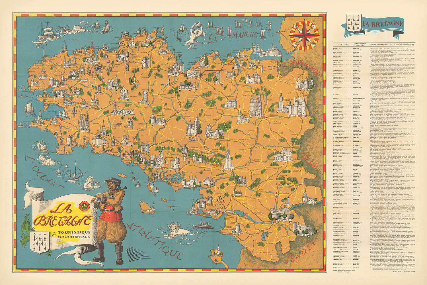
Immerse yourself in the enchanting region of Brittany with "La Bretagne Touristique et Monumentale," an exquisite 1950 pictorial map by the esteemed...
Continue readingImmerse yourself in the enchanting region of Brittany with "La Bretagne Touristique et Monumentale," an exquisite 1950 pictorial map by the esteemed cartographer Flornoy Jean. Bearing its original French title, this map is a celebration of Brittany’s storied past and vibrant culture, capturing the essence of a land where ancient traditions meet breathtaking landscapes. Designed at a time when post-war France was rediscovering its regional identities, the map offers a unique window into the soul of Brittany, inviting viewers to explore its monumental heritage and scenic wonders through the eyes of a master mapmaker.
Flornoy Jean’s artistry is immediately evident in the map’s thematic and pictorial style, where every corner is adorned with evocative illustrations of Brittany’s most cherished landmarks. Medieval castles rise majestically from the countryside, while ancient churches and abbeys punctuate the rolling landscape, each rendered with meticulous attention to architectural detail. The map’s design is not merely functional; it is a work of art, seamlessly blending geographic precision with vibrant visual storytelling, making it as captivating for collectors as it is informative for historians and travelers.
The map’s coverage is both comprehensive and intimate, encompassing the entirety of Brittany—one of France’s most distinctive regions, famed for its Celtic roots and rugged coastline. Major cities such as Nantes, Rennes, and Brest are prominently featured, their historical significance underscored by surrounding illustrations of fortresses, cathedrals, and bustling ports. Yet, the map also celebrates the charm of lesser-known towns and the natural beauty of Brittany’s rivers, forests, and dramatic seascapes, offering a holistic portrait of the region’s physical and cultural geography.
One of the most striking aspects of "La Bretagne Touristique et Monumentale" is its celebration of Breton identity. The map is rich with symbols of regional pride, from the iconic Breton flags and coats of arms to lively depictions of traditional folk costumes. Scattered throughout are evocative representations of prehistoric megaliths—menhirs and dolmens—that speak to Brittany’s ancient heritage, as well as lighthouses and coastal landmarks that highlight the enduring relationship between the Bretons and the sea.
Historically, this map stands as a testament to the renewed appreciation for local culture and tourism in mid-20th-century France. Created during a period of national recovery and regional revival, it not only guided travelers to Brittany’s most treasured sites but also fostered a deeper understanding of the region’s unique legacy. For the discerning collector or connoisseur of history, Flornoy Jean’s masterpiece offers both a visual feast and a richly layered narrative—an invitation to journey through time and place, discovering the enduring allure of Brittany in every detail.
Cities and towns on this map
- Nantes
- Rennes
- Brest
- Saint-Malo
- Quimper
- Vannes
- Lorient
- Saint-Brieuc
- Morlaix
Notable Features & Landmarks
- Illustrations of historical monuments such as medieval castles, fortresses, and ancient churches.
- Depictions of Brittany's coastline, including notable lighthouses and coastal landmarks.
- Visual representation of traditional Breton culture, including folk costumes and cultural symbols.
- Prominent illustrations of significant religious sites, such as cathedrals and abbeys.
- Notable natural landmarks, including forests, rivers, and coastal features.
- Artistic representations of regional symbols, such as Breton flags and coats of arms.
- Depiction of megalithic monuments (e.g., menhirs and dolmens), characteristic of Brittany's prehistoric heritage.
Historical and design context
- Created in 1950 by Flornoy Jean, a cartographer known for thematic and pictorial maps.
- Emphasizes tourism, historical monuments, architectural landmarks, cultural heritage, and scenic beauty of Brittany.
- Pictorial and thematic style, combining artistic illustrations with geographic accuracy.
- Created post-World War II, reflecting renewed interest in regional heritage and identity in France.
- Serves as a visual guide to Brittany’s rich cultural heritage, historical landmarks, charming villages, ancient churches, and notable monuments.
Please double check the images to make sure that a specific town or place is shown on this map. You can also get in touch and ask us to check the map for you.
This map looks great at every size, but I always recommend going for a larger size if you have space. That way you can easily make out all of the details.
This map looks amazing at sizes all the way up to 100in (250cm). If you are looking for a larger map, please get in touch.
Please note: the labels on this map are hard to read if you order a map that is 16in (40cm) or smaller. The map is still very attractive, but if you would like to read the map easily, please buy a larger size.
The model in the listing images is holding the 24x36in (60x90cm) version of this map.
The fifth listing image shows an example of my map personalisation service.
If you’re looking for something slightly different, check out my collection of the best old maps to see if something else catches your eye.
Please contact me to check if a certain location, landmark or feature is shown on this map.
This would make a wonderful birthday, Christmas, Father's Day, work leaving, anniversary or housewarming gift for someone from the areas covered by this map.
This map is available as a giclée print on acid free archival matte paper, or you can buy it framed. The frame is a nice, simple black frame that suits most aesthetics. Please get in touch if you'd like a different frame colour or material. My frames are glazed with super-clear museum-grade acrylic (perspex/acrylite), which is significantly less reflective than glass, safer, and will always arrive in perfect condition.
This map is also available as a float framed canvas, sometimes known as a shadow gap framed canvas or canvas floater. The map is printed on artist's cotton canvas and then stretched over a handmade box frame. We then "float" the canvas inside a wooden frame, which is available in a range of colours (black, dark brown, oak, antique gold and white). This is a wonderful way to present a map without glazing in front. See some examples of float framed canvas maps and explore the differences between my different finishes.
For something truly unique, this map is also available in "Unique 3D", our trademarked process that dramatically transforms the map so that it has a wonderful sense of depth. We combine the original map with detailed topography and elevation data, so that mountains and the terrain really "pop". For more info and examples of 3D maps, check my Unique 3D page.
Immerse yourself in the enchanting region of Brittany with "La Bretagne Touristique et Monumentale," an exquisite 1950 pictorial map by the esteemed cartographer Flornoy Jean. Bearing its original French title, this map is a celebration of Brittany’s storied past and vibrant culture, capturing the essence of a land where ancient traditions meet breathtaking landscapes. Designed at a time when post-war France was rediscovering its regional identities, the map offers a unique window into the soul of Brittany, inviting viewers to explore its monumental heritage and scenic wonders through the eyes of a master mapmaker.
Flornoy Jean’s artistry is immediately evident in the map’s thematic and pictorial style, where every corner is adorned with evocative illustrations of Brittany’s most cherished landmarks. Medieval castles rise majestically from the countryside, while ancient churches and abbeys punctuate the rolling landscape, each rendered with meticulous attention to architectural detail. The map’s design is not merely functional; it is a work of art, seamlessly blending geographic precision with vibrant visual storytelling, making it as captivating for collectors as it is informative for historians and travelers.
The map’s coverage is both comprehensive and intimate, encompassing the entirety of Brittany—one of France’s most distinctive regions, famed for its Celtic roots and rugged coastline. Major cities such as Nantes, Rennes, and Brest are prominently featured, their historical significance underscored by surrounding illustrations of fortresses, cathedrals, and bustling ports. Yet, the map also celebrates the charm of lesser-known towns and the natural beauty of Brittany’s rivers, forests, and dramatic seascapes, offering a holistic portrait of the region’s physical and cultural geography.
One of the most striking aspects of "La Bretagne Touristique et Monumentale" is its celebration of Breton identity. The map is rich with symbols of regional pride, from the iconic Breton flags and coats of arms to lively depictions of traditional folk costumes. Scattered throughout are evocative representations of prehistoric megaliths—menhirs and dolmens—that speak to Brittany’s ancient heritage, as well as lighthouses and coastal landmarks that highlight the enduring relationship between the Bretons and the sea.
Historically, this map stands as a testament to the renewed appreciation for local culture and tourism in mid-20th-century France. Created during a period of national recovery and regional revival, it not only guided travelers to Brittany’s most treasured sites but also fostered a deeper understanding of the region’s unique legacy. For the discerning collector or connoisseur of history, Flornoy Jean’s masterpiece offers both a visual feast and a richly layered narrative—an invitation to journey through time and place, discovering the enduring allure of Brittany in every detail.
Cities and towns on this map
- Nantes
- Rennes
- Brest
- Saint-Malo
- Quimper
- Vannes
- Lorient
- Saint-Brieuc
- Morlaix
Notable Features & Landmarks
- Illustrations of historical monuments such as medieval castles, fortresses, and ancient churches.
- Depictions of Brittany's coastline, including notable lighthouses and coastal landmarks.
- Visual representation of traditional Breton culture, including folk costumes and cultural symbols.
- Prominent illustrations of significant religious sites, such as cathedrals and abbeys.
- Notable natural landmarks, including forests, rivers, and coastal features.
- Artistic representations of regional symbols, such as Breton flags and coats of arms.
- Depiction of megalithic monuments (e.g., menhirs and dolmens), characteristic of Brittany's prehistoric heritage.
Historical and design context
- Created in 1950 by Flornoy Jean, a cartographer known for thematic and pictorial maps.
- Emphasizes tourism, historical monuments, architectural landmarks, cultural heritage, and scenic beauty of Brittany.
- Pictorial and thematic style, combining artistic illustrations with geographic accuracy.
- Created post-World War II, reflecting renewed interest in regional heritage and identity in France.
- Serves as a visual guide to Brittany’s rich cultural heritage, historical landmarks, charming villages, ancient churches, and notable monuments.
Please double check the images to make sure that a specific town or place is shown on this map. You can also get in touch and ask us to check the map for you.
This map looks great at every size, but I always recommend going for a larger size if you have space. That way you can easily make out all of the details.
This map looks amazing at sizes all the way up to 100in (250cm). If you are looking for a larger map, please get in touch.
Please note: the labels on this map are hard to read if you order a map that is 16in (40cm) or smaller. The map is still very attractive, but if you would like to read the map easily, please buy a larger size.
The model in the listing images is holding the 24x36in (60x90cm) version of this map.
The fifth listing image shows an example of my map personalisation service.
If you’re looking for something slightly different, check out my collection of the best old maps to see if something else catches your eye.
Please contact me to check if a certain location, landmark or feature is shown on this map.
This would make a wonderful birthday, Christmas, Father's Day, work leaving, anniversary or housewarming gift for someone from the areas covered by this map.
This map is available as a giclée print on acid free archival matte paper, or you can buy it framed. The frame is a nice, simple black frame that suits most aesthetics. Please get in touch if you'd like a different frame colour or material. My frames are glazed with super-clear museum-grade acrylic (perspex/acrylite), which is significantly less reflective than glass, safer, and will always arrive in perfect condition.
This map is also available as a float framed canvas, sometimes known as a shadow gap framed canvas or canvas floater. The map is printed on artist's cotton canvas and then stretched over a handmade box frame. We then "float" the canvas inside a wooden frame, which is available in a range of colours (black, dark brown, oak, antique gold and white). This is a wonderful way to present a map without glazing in front. See some examples of float framed canvas maps and explore the differences between my different finishes.
For something truly unique, this map is also available in "Unique 3D", our trademarked process that dramatically transforms the map so that it has a wonderful sense of depth. We combine the original map with detailed topography and elevation data, so that mountains and the terrain really "pop". For more info and examples of 3D maps, check my Unique 3D page.
Many of our maps and art prints are chosen as thoughtful gifts for homes, offices, studies and meaningful places.
Choose a framed option for the easiest ready-to-hang gift, or choose an unframed print if the recipient may prefer to select their own frame.
We make orders locally in 23 countries around the world, so gifts can often be produced close to the recipient. This helps them arrive faster, travel more safely, and avoid customs or import duty surprises.
- We can deliver directly to the recipient
- Framed pieces arrive ready to hang
- Unframed prints are carefully packed in a strong protective tube
- Almost every order is made locally, for faster, safer gifting
- 90-day returns give the recipient time to decide
If you are not sure what to choose, please contact us. We can help you pick the right map, size, finish or delivery option.
Most orders are made locally and delivered in around 2–3 working days, depending on the product, size and destination.
We print and frame maps and artwork in 23 countries around the world, so your order is usually made close to you or your recipient. That means faster delivery, less time in transit, and no customs or import duty surprises.
Personalised and customised pieces usually take an extra 1–2 working days, because we prepare your design and send it to you for approval before printing.
Very large framed orders can take a little longer, as they need extra care in production and delivery.
Every order is carefully packaged: unframed prints are sent in a strong protective tube, while framed pieces are securely packed with protective materials around the frame.
If you need your order by a particular date, please contact us before ordering. We’ll check the best production route and delivery option for your location.
Express delivery is available at checkout for most countries. Next-day delivery is available in the UK, US, Singapore and the UAE.
Your order is covered by our 90-day returns policy and 10-year guarantee.
Our standard frame is a gallery-style black ash hardwood frame, with a simple, modern look. It is approximately 20mm (0.8in) wide. You can also view some lovely customer photos of framed maps and art.
We use super-clear acrylic glazing, also known as Perspex or Acrylite, instead of traditional glass. It is lighter, safer, and has lower reflectivity, giving the artwork a clearer, cleaner appearance.
Six standard frame colours are available at no extra cost: black, dark brown, dark grey, oak, white, and antique gold. Custom framing and mounting/matting is also available for customers looking for something more specific.
Most maps, art prints, and illustrations are also available as a framed canvas. We use matte cotton canvas, stretch it over a sustainably sourced wooden box frame, and then float the piece within a wooden outer frame. The finished result is beautifully presented, with no glazing between you and the artwork.
All frames are supplied ready to hang, with either string or brackets fitted to the back. Very large frames will include heavy-duty hanging plates and/or a mounting baton. If you have any questions, please get in touch.
We can also supply old maps and artwork on canvas, foam board, cotton rag, and other materials.
If you would prefer to frame your map or artwork yourself, please read our size guide before ordering.
My maps are extremely high quality reproductions of original maps.
I source original, rare maps from libraries, auction houses and private collections around the world, restore them at my London workshop, and then use specialist giclée inks and printers to create beautiful maps that look even better than the original.
My maps are printed on acid-free archival matte (not glossy) paper that feels very high quality and almost like card. In technical terms the paper weight/thickness is 10mil/200gsm. It's perfect for framing.
I print with Epson ultrachrome giclée UV fade resistant pigment inks - some of the best inks you can find.
I can also make maps on canvas, cotton rag and other exotic materials.
Learn more about The Unique Maps Co.
Map personalisation
If you're looking for the perfect anniversary or housewarming gift, I can personalise your map to make it truly unique. For example, I can add a short message, or highlight an important location, or add your family's coat of arms.
The options are almost infinite. Please see my map personalisation page for some wonderful examples of what's possible.
To order a personalised map, select "personalise your map" before adding it to your basket.
Get in touch if you're looking for more complex customisations and personalisations.
Map ageing
I have been asked hundreds of times over the years by customers if they could buy a map that looks even older.
Well, now you can, by selecting Aged before you add a map to your basket.
All the product photos you see on this page show the map in its Original form. This is what the map looks like today.
If you select Aged, I will age your map by hand, using a special and unique process developed through years of studying old maps, talking to researchers to understand the chemistry of aging paper, and of course... lots of practice!
If you're unsure, stick to the Original colour of the map. If you want something a bit darker and older looking, go for Aged.
If you are not happy with your order for any reason, contact me and I'll get it fixed ASAP, free of charge. Please see my returns and refund policy for more information.
I am very confident you will like your restored map or art print. I have been doing this since 1984. I'm a 5-star Etsy seller. I have sold tens of thousands of maps and art prints and have over 5,000 real 5-star reviews. My work has been featured in interior design magazines, on the BBC, and on the walls of dozens of 5-star hotels.
I use a unique process to restore maps and artwork that is massively time consuming and labour intensive. Hunting down the original maps and illustrations can take months. I use state of the art and eye-wateringly expensive technology to scan and restore them. As a result, I guarantee my maps and art prints are a cut above the rest. I stand by my products and will always make sure you're 100% happy with what you receive.
Almost all of my maps and art prints look amazing at large sizes (200cm, 6.5ft+) and I can frame and deliver them to you as well, via special oversized courier. Contact me to discuss your specific needs.
Or try searching for something!


