


Rare Old Historical Map of Scotland by Bullock, 1950: Clans, Tartans, Battles, Castles, Wildlife, Coats of Arms
20% off 2 — 33% off 3
Add any two eligible items to your bag to receive 20% off. Add a third and it will be complimentary (equivalent to 33% off when purchasing three).
No code needed — the offer applies automatically at checkout.
Valid on all standard maps and fine art prints. You can mix and match any designs.
If you’d like to ship items to multiple addresses, please contact us before placing your order.
Custom and bespoke commissions are excluded.
Contact us if you have any questions
 Designed in London Made in the UK
Designed in London • Made in the UK
Designed in London Made in the UK
Designed in London • Made in the UK

Choose your size
Framing


(More info)
Gift message & custom finish

If you want to add a gift message, or a finish (jigsaw, aluminium board, etc.) that is not available here, please request it in the "order note" when you check out.
Every order is custom made, so if you need the size adjusted slightly, or printed on an unusual material, just let us know. We've done thousands of custom orders over the years, so there's (almost) nothing we can't manage.
You can also contact us before you order, if you prefer!

- Made locally for fast, safe delivery
- Free worldwide delivery, with no import duty surprises
- 90-day returns and 5-year guarantee
- Need advice? Message us on WhatsApp
Own a piece of history
7,000+ 5 star reviews


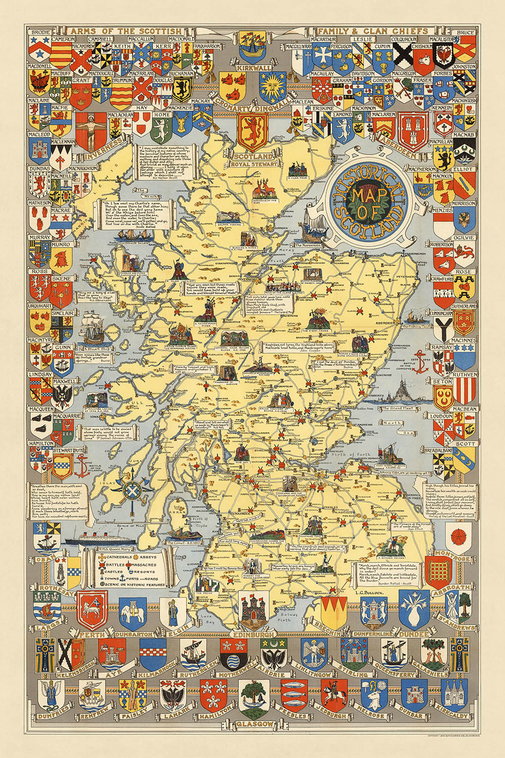
Embark on a visual journey through the rich tapestry of Scotland's past with the "Historical Map of Scotland," meticulously crafted by the esteemed British cartographer LG Bullock in 1950. This thematic and pictorial masterpiece is not merely a map but a vibrant narrative of Scotland's storied history, encapsulated within the borders of its modern-day countries, including Scotland, England, and Northern Ireland. Through Bullock's skilled hand, the map becomes a gateway to understanding the profound historical events, illustrious clans, and the very essence of Scottish heritage. As a celebrated figure known for his contributions to the "Ordnance Survey" maps, Bullock's expertise in cartography shines through in this work, offering a glimpse into the heart of Scotland as seen through the eyes of a master mapmaker.
The "Historical Map of Scotland" is a treasure trove of visual information, adorned with the coats of arms of major cities, towns, and the distinguished Scottish clan and family chiefs. This intricate detailing not only adds a layer of aesthetic appeal but serves as a testament to the map's historical and cultural significance. Each emblem tells a story of lineage, power, and the intricate web of alliances and rivalries that have shaped Scotland's history. From the Highlands to the Lowlands and the Islands, the map delineates the regions of Scotland, providing a backdrop to the historical narratives embedded within its illustrations.
Pictorial images scattered across the map breathe life into Scotland's past, depicting tartans, clan crests, landmarks, historical events, and the rich biodiversity of Scottish wildlife. These illustrations are more than mere decorations; they are visual cues that invite the viewer to explore Scotland's cultural heritage, from traditional crafts and trades to the spirited melodies of traditional music and dance. The map serves as a visual encyclopedia, capturing the essence of Scottish life through its depiction of traditional costumes, weapons, architecture, and landscapes.
Significant historical events and sites are immortalized on this map, offering a unique perspective on Scotland's history. The crowning of Bruce at Scone in 1306 and the tragic massacre in Glencoe in 1692 are but a few examples of the pivotal moments illustrated. These depictions, alongside the sites of cathedrals, abbeys, castles, and battles, provide a narrative thread that weaves through centuries of Scottish history. The map's ability to convey such a wealth of information pictorially makes it not only a valuable historical document but also a piece of art that captures the imagination.
In essence, the "Historical Map of Scotland" by LG Bullock is a masterpiece that transcends the conventional boundaries of cartography. It is a celebration of Scotland's rich heritage, a visual compendium of its history, culture, and natural beauty. For historians, cartography enthusiasts, and anyone fascinated by Scotland, this map offers an unparalleled exploration of the country's past, presented through the lens of one of Britain's most skilled mapmakers. As a luxury item, it represents a unique opportunity to own a piece of history, meticulously rendered with an eye for detail and a deep appreciation for the stories that have shaped the land and its people.
Places on this map
- Aberdeen
- Aboyne
- Airdrie
- Alloa
- Annan
- Arbroath
- Ardrossan
- Ayr
- Banff
- Barrhead
- Bathgate
- Beauly
- Berwick-upon-Tweed
- Blair Atholl
- Blairgowrie
- Bo'ness
- Brechin
- Bridge of Allan
- Buckie
- Burghead
Notable Features & Landmarks
- Pictorial images of various Scottish tartans
- Pictorial images of various Scottish clan crests
- Pictorial images of various Scottish landmarks
- Pictorial images of various Scottish historical events
- Pictorial images of various Scottish wildlife
- Pictorial images of various Scottish industries
- Pictorial images of various Scottish traditional activities
- Pictorial images of various Scottish traditional foods
- Pictorial images of various Scottish traditional music and dance
- Pictorial images of various Scottish traditional sports
- Pictorial images of various Scottish traditional festivals and events
- Pictorial images of various Scottish traditional crafts and trades
- Pictorial images of various Scottish traditional costumes
- Pictorial images of various Scottish traditional weapons and armour
- Pictorial images of various Scottish traditional food and drink
- Pictorial images of various Scottish traditional games and sports
- Pictorial images of various Scottish traditional crafts and industries
- Pictorial images of various Scottish traditional architecture
- Pictorial images of various Scottish traditional landscapes
- Pictorial images of various Scottish traditional plants and flowers
- Pictorial images of various Scottish traditional animals
- Pictorial images of various Scottish traditional birds
- Pictorial images of various Scottish traditional fish
- Pictorial images of various Scottish traditional insects
- Pictorial images of various Scottish traditional reptiles
- Pictorial images of various Scottish traditional amphibians
- Pictorial images of various Scottish traditional mammals
Historical and design context
- The map was created by LG Bullock in 1950.
- LG Bullock was a British cartographer and mapmaker, best known for his work on the "Ordnance Survey" maps of Great Britain.
- The map is a pictorial map, using pictures and illustrations to show information.
- It shows the coats of arms of the main cities and towns in Scotland.
- It shows the coats of arms of the Scottish clan and family chiefs.
- It illustrates places and events in Scotland's history.
- It shows the sites of cathedrals, abbeys, castles, and battles.
- The map is decorated with illustrations of Scottish people, animals, and plants.
- It is a valuable historical document that provides a glimpse into Scotland's past.
Please double check the images to make sure that a specific town or place is shown on this map. You can also get in touch and ask us to check the map for you.
This map looks great at every size, but I always recommend going for a larger size if you have space. That way you can easily make out all of the details.
This map looks amazing at sizes all the way up to 100in (250cm). If you are looking for a larger map, please get in touch.
Please note: the labels on this map are hard to read if you order a map that is 16in (40cm) or smaller. The map is still very attractive, but if you would like to read the map easily, please buy a larger size.
The model in the listing images is holding the 24x36in (60x90cm) version of this map.
The fifth listing image shows an example of my map personalisation service.
If you’re looking for something slightly different, check out my collection of the best old maps to see if something else catches your eye.
Please contact me to check if a certain location, landmark or feature is shown on this map.
This would make a wonderful birthday, Christmas, Father's Day, work leaving, anniversary or housewarming gift for someone from the areas covered by this map.
This map is available as a giclée print on acid free archival matte paper, or you can buy it framed. The frame is a nice, simple black frame that suits most aesthetics. Please get in touch if you'd like a different frame colour or material. My frames are glazed with super-clear museum-grade acrylic (perspex/acrylite), which is significantly less reflective than glass, safer, and will always arrive in perfect condition.
This map is also available as a float framed canvas, sometimes known as a shadow gap framed canvas or canvas floater. The map is printed on artist's cotton canvas and then stretched over a handmade box frame. We then "float" the canvas inside a wooden frame, which is available in a range of colours (black, dark brown, oak, antique gold and white). This is a wonderful way to present a map without glazing in front. See some examples of float framed canvas maps and explore the differences between my different finishes.
For something truly unique, this map is also available in "Unique 3D", our trademarked process that dramatically transforms the map so that it has a wonderful sense of depth. We combine the original map with detailed topography and elevation data, so that mountains and the terrain really "pop". For more info and examples of 3D maps, check my Unique 3D page.
Many of our maps and art prints are chosen as thoughtful gifts for homes, offices, studies and meaningful places.
Choose a framed option for the easiest ready-to-hang gift, or choose an unframed print if the recipient may prefer to select their own frame.
We make orders locally in 23 countries around the world, so gifts can often be produced close to the recipient. This helps them arrive faster, travel more safely, and avoid customs or import duty surprises.
- We can deliver directly to the recipient
- Framed pieces arrive ready to hang
- Unframed prints are carefully packed in a strong protective tube
- Almost every order is made locally, for faster, safer gifting
- 90-day returns give the recipient time to decide
If you are not sure what to choose, please contact us. We can help you pick the right map, size, finish or delivery option.
Most orders are made locally and delivered in around 2–3 working days, depending on the product, size and destination.
We print and frame maps and artwork in 23 countries around the world, so your order is usually made close to you or your recipient. That means faster delivery, less time in transit, and no customs or import duty surprises.
Personalised and customised pieces usually take an extra 1–2 working days, because we prepare your design and send it to you for approval before printing.
Very large framed orders can take a little longer, as they need extra care in production and delivery.
Every order is carefully packaged: unframed prints are sent in a strong protective tube, while framed pieces are securely packed with protective materials around the frame.
If you need your order by a particular date, please contact us before ordering. We’ll check the best production route and delivery option for your location.
Express delivery is available at checkout for most countries. Next-day delivery is available in the UK, US, Singapore and the UAE.
Your order is covered by our 90-day returns policy and 5-year guarantee.
My standard frame is a gallery style black ash hardwood frame. It is simple and quite modern looking. My standard frame is around 20mm (0.8in) wide.
I use super-clear acrylic (perspex/acrylite) for the frame glass. It's lighter and safer than glass - and it looks better, as the reflectivity is lower.
Six standard frame colours are available for free (black, dark brown, dark grey, oak, white and antique gold). Custom framing and mounting/matting is available if you're looking for something else.
Most maps, art and illustrations are also available as a framed canvas. We use matte (not shiny) cotton canvas, stretch it over a sustainably sourced box wood frame, and then 'float' the piece within a wood frame. The end result is quite beautiful, and there's no glazing to get in the way.
All frames are provided "ready to hang", with either a string or brackets on the back. Very large frames will have heavy duty hanging plates and/or a mounting baton. If you have any questions, please get in touch.
See some examples of my framed maps and framed canvas maps.
Alternatively, I can also supply old maps and artwork on canvas, foam board, cotton rag and other materials.
If you want to frame your map or artwork yourself, please read my size guide first.
My maps are extremely high quality reproductions of original maps.
I source original, rare maps from libraries, auction houses and private collections around the world, restore them at my London workshop, and then use specialist giclée inks and printers to create beautiful maps that look even better than the original.
My maps are printed on acid-free archival matte (not glossy) paper that feels very high quality and almost like card. In technical terms the paper weight/thickness is 10mil/200gsm. It's perfect for framing.
I print with Epson ultrachrome giclée UV fade resistant pigment inks - some of the best inks you can find.
I can also make maps on canvas, cotton rag and other exotic materials.
Learn more about The Unique Maps Co.
Map personalisation
If you're looking for the perfect anniversary or housewarming gift, I can personalise your map to make it truly unique. For example, I can add a short message, or highlight an important location, or add your family's coat of arms.
The options are almost infinite. Please see my map personalisation page for some wonderful examples of what's possible.
To order a personalised map, select "personalise your map" before adding it to your basket.
Get in touch if you're looking for more complex customisations and personalisations.
Map ageing
I have been asked hundreds of times over the years by customers if they could buy a map that looks even older.
Well, now you can, by selecting Aged before you add a map to your basket.
All the product photos you see on this page show the map in its Original form. This is what the map looks like today.
If you select Aged, I will age your map by hand, using a special and unique process developed through years of studying old maps, talking to researchers to understand the chemistry of aging paper, and of course... lots of practice!
If you're unsure, stick to the Original colour of the map. If you want something a bit darker and older looking, go for Aged.
If you are not happy with your order for any reason, contact me and I'll get it fixed ASAP, free of charge. Please see my returns and refund policy for more information.
I am very confident you will like your restored map or art print. I have been doing this since 1984. I'm a 5-star Etsy seller. I have sold tens of thousands of maps and art prints and have over 5,000 real 5-star reviews. My work has been featured in interior design magazines, on the BBC, and on the walls of dozens of 5-star hotels.
I use a unique process to restore maps and artwork that is massively time consuming and labour intensive. Hunting down the original maps and illustrations can take months. I use state of the art and eye-wateringly expensive technology to scan and restore them. As a result, I guarantee my maps and art prints are a cut above the rest. I stand by my products and will always make sure you're 100% happy with what you receive.
Almost all of my maps and art prints look amazing at large sizes (200cm, 6.5ft+) and I can frame and deliver them to you as well, via special oversized courier. Contact me to discuss your specific needs.
Or try searching for something!


