


Rare Old Map of South Australia by Tallis, 1851: Adelaide, Spencer Gulf, Kangaroo Is., Yorke Pen., Mt Gambier
20% off 2 — 33% off 3
Add any two eligible items to your bag to receive 20% off. Add a third and it will be complimentary (equivalent to 33% off when purchasing three).
No code needed — the offer applies automatically at checkout.
Valid on all standard maps and fine art prints. You can mix and match any designs.
If you’d like to ship items to multiple addresses, please contact us before placing your order.
Custom and bespoke commissions are excluded.
Contact us if you have any questions
 Designed in London Made in the UK
Designed in London • Made in the UK
Designed in London Made in the UK
Designed in London • Made in the UK

Choose your size
Choose your finish


(More info)
Gift message & custom finish

If you want to add a gift message, or a finish (jigsaw, aluminium board, etc.) that is not available here, please request it in the "order note" when you check out.
Every order is custom made, so if you need the size adjusted slightly, or printed on an unusual material, just let us know. We've done thousands of custom orders over the years, so there's (almost) nothing we can't manage.
You can also contact us before you order, if you prefer!

- Made locally for fast, safe delivery
- No import duty or hidden fees
- Need advice? Message us on WhatsApp
Own a piece of history
7,000+ 5 star reviews


Part of South Australia, issued in 1851 by John Tallis for R. Montgomery Martin’s Illustrated Atlas, presents a richly observed portrait of the colony at mid-century. Centered on Spencer Gulf and the York Peninsula, the map reaches eastward to Encounter Bay and southward to Kangaroo Island, while extending up the western coast as far as Port Drummond. Tallis deftly marries political and physical geography: the coastline is crisply delineated, gulfs and bays are carefully named, and color-washed counties articulate the administrative lattice overlaying new settlements. Adelaide and Port Adelaide form the metropolitan anchor, with Victor Harbor marking the curve of Encounter Bay and Mount Gambier signaling the colony’s broader reach. The result is a work that captures both the order of colonial planning and the drama of Australia’s southern seaboard.
This is Tallis at his most engaging: an elegant decorative border frames a sequence of vignettes that animate the landscape with story and symbolism. A panoramic view of Adelaide introduces the civic heart of the colony, while an image of Indigenous people with a raft acknowledges the waterborne lifeways that predate European arrival. A Dingo and a Nymphicus (parakeet) add natural-history grace notes, balancing urban ambition with the wild vitality of the bush. In the lower-left corner, the seal of South Australia lends official gravitas. Together these scenes transform the sheet from a mere reference into a visual essay—part atlas, part album—typical of Tallis’s celebrated fusion of science and spectacle.
Geographically, the map excels in expressing the coast’s intricate physiognomy. The long body of Spencer Gulf carves deep into the mainland, its sheltered waters flanked by the York Peninsula to the east and a rugged western littoral running up toward Port Drummond. Kangaroo Island stands sentinel at the gulf’s mouth, a maritime landmark separating open ocean from the complex inshore waterways. The curve of Encounter Bay opens toward Victor Harbor, while smaller bays, capes, and islands on both gulfs articulate a coast alive with navigational detail. Inland, the shading and linework trace undulating terrains and watercourses, hinting at ranges and river systems that break the plains—an evocative physical backdrop to the settlements strung along the shore.
Politically, the coloring by counties conveys the early framework of colonial administration, a patchwork of jurisdictions superimposed upon a varied landscape. These tinted divisions delineate spheres of governance and land tenure, reflecting the era’s survey-driven rationality. Towns and ports appear as nodal points: Adelaide, the planned capital; Port Adelaide, the arterial gateway; Victor Harbor, poised at the edge of Encounter Bay; and Mount Gambier, evidencing expansion toward the colony’s southeastern reaches. The harmony—and sometimes tension—between these political boundaries and the physical geography is a central theme: counties hugging the gulfs, settlements tracking waterways and harbors, and the open interior inviting further exploration and pastoral enterprise.
Historically, the map captures South Australia at a formative moment, as survey, settlement, and commerce accelerated in step with broader currents sweeping mid-19th-century Australia. Tallis, one of the last great decorative mapmakers, distills that momentum into an atlas page where accurate delineation and narrative imagery coexist. The vignettes of Indigenous life and native fauna mirror European curiosity while acknowledging older presences and ecologies, even as the county grid records a colonial order advancing apace. As a whole, the sheet stands as a concise chronicle: a coastal dominion defined by gulfs and islands, towns tethered to harbors, and a young polity asserting itself with seals and borders. It is an eloquent summation of place, period, and the Tallis signature.
Cities and towns on this map
- Adelaide
- Port Adelaide
- Mount Gambier
- Victor Harbor
Notable Features & Landmarks
- Vignettes of Adelaide, indigenous people on a raft, a Dingo, and a Nymphicus
- Political boundaries delineated by color-coded counties
- Major geographical features like Spencer Gulf, York Peninsula, and Kangaroo Island
- The seal of South Australia depicted in the lower-left corner
Historical and design context
- Creation date: 1851
- Mapmaker/publisher: John Tallis; published in R. Montgomery Martin's Illustrated Atlas
- John Tallis is recognized as one of the last great decorative map makers, noted for ornate elements and vignettes that make his maps highly collectible
- Intricate borders and detailed vignettes exemplify an artistic, decorative approach to cartography
- Colored by counties to highlight administrative divisions, merging political and physical geography
- Represents mid-19th century South Australia, reflecting European settlement patterns alongside Indigenous presence
- Themes include political boundaries, physical features, and cultural depictions of Indigenous life and regional wildlife
Please double check the images to make sure that a specific town or place is shown on this map. You can also get in touch and ask us to check the map for you.
This map looks great at every size, but I always recommend going for a larger size if you have space. That way you can easily make out all of the details.
This map looks amazing at sizes all the way up to 50in (125cm). If you are looking for a larger map, please get in touch.
The model in the listing images is holding the 18x24in (45x60cm) version of this map.
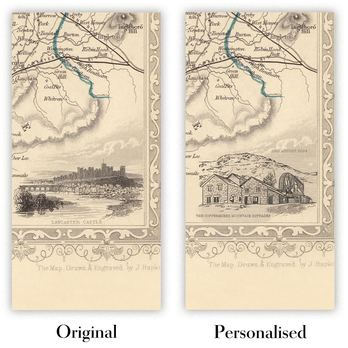
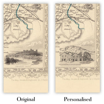
The fifth listing image shows an example of my map personalisation service.
If you’re looking for something slightly different, check out my collection of the best old maps to see if something else catches your eye.
Please contact me to check if a certain location, landmark or feature is shown on this map.
This would make a wonderful birthday, Christmas, Father's Day, work leaving, anniversary or housewarming gift for someone from the areas covered by this map.
This map is available as a giclée print on acid free archival matte paper, or you can buy it framed. The frame is a nice, simple black frame that suits most aesthetics. Please get in touch if you'd like a different frame colour or material. My frames are glazed with super-clear museum-grade acrylic (perspex/acrylite), which is significantly less reflective than glass, safer, and will always arrive in perfect condition.
This map is also available as a float framed canvas, sometimes known as a shadow gap framed canvas or canvas floater. The map is printed on artist's cotton canvas and then stretched over a handmade box frame. We then "float" the canvas inside a wooden frame, which is available in a range of colours (black, dark brown, oak, antique gold and white). This is a wonderful way to present a map without glazing in front. See some examples of float framed canvas maps and explore the differences between my different finishes.
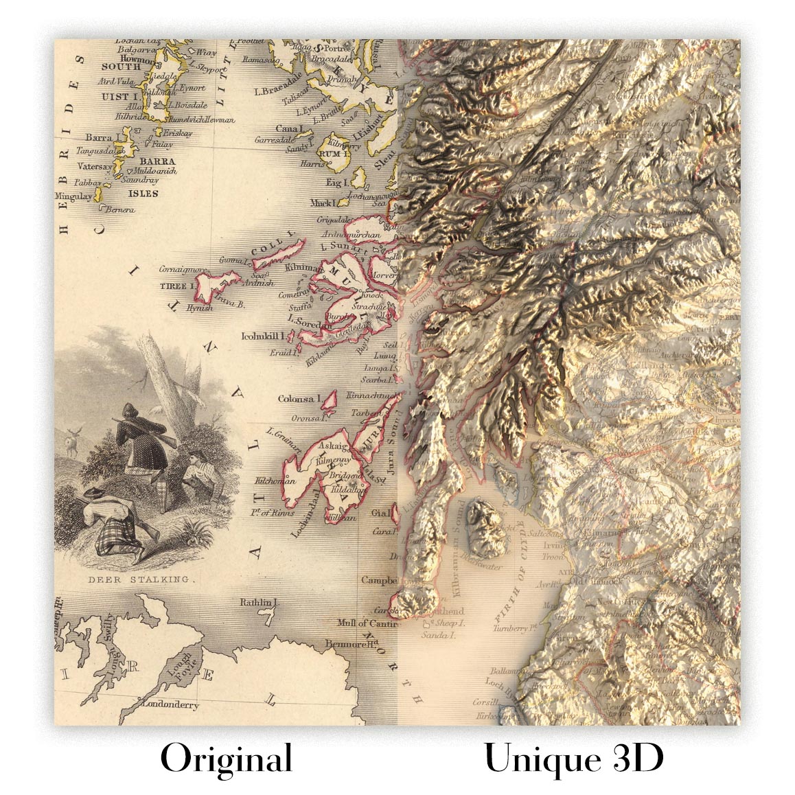
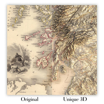
For something truly unique, this map is also available in "Unique 3D", our trademarked process that dramatically transforms the map so that it has a wonderful sense of depth. We combine the original map with detailed topography and elevation data, so that mountains and the terrain really "pop". For more info and examples of 3D maps, check my Unique 3D page.
Many of our maps and art prints are chosen as thoughtful gifts for homes, offices, studies and meaningful places.
Choose a framed option for the easiest ready-to-hang gift, or choose an unframed print if the recipient may prefer to select their own frame.
We make orders locally in 23 countries around the world, so gifts can often be produced close to the recipient. This helps them arrive faster, travel more safely, and avoid customs or import duty surprises.
- We can deliver directly to the recipient
- Framed pieces arrive ready to hang
- Unframed prints are carefully packed in a strong protective tube
- Almost every order is made locally, for faster, safer gifting
- 90-day returns give the recipient time to decide
If you are not sure what to choose, please contact us. We can help you pick the right map, size, finish or delivery option.
Most orders are made locally and delivered in around 2–3 working days, depending on the product, size and destination.
We print and frame maps and artwork in 23 countries around the world, so your order is usually made close to you or your recipient. That means faster delivery, less time in transit, and no customs or import duty surprises.
Personalised and customised pieces usually take an extra 1–2 working days, because we prepare your design and send it to you for approval before printing.
Very large framed orders can take a little longer, as they need extra care in production and delivery.
Every order is carefully packaged: unframed prints are sent in a strong protective tube, while framed pieces are securely packed with protective materials around the frame.
If you need your order by a particular date, please contact us before ordering. We’ll check the best production route and delivery option for your location.
Express delivery is available at checkout for most countries. Next-day delivery is available in the UK, US, Singapore and the UAE.
Your order is covered by our 90-day returns policy and 10-year guarantee.
Our standard frame is a gallery-style black ash hardwood frame, with a simple, modern look. It is approximately 20mm (0.8in) wide. You can also view some lovely customer photos of framed maps and art.
We use super-clear acrylic glazing, also known as Perspex or Acrylite, instead of traditional glass. It is lighter, safer, and has lower reflectivity, giving the artwork a clearer, cleaner appearance.
Six standard frame colours are available at no extra cost: black, dark brown, dark grey, oak, white, and antique gold. Custom framing and mounting/matting is also available for customers looking for something more specific.
Most maps, art prints, and illustrations are also available as a framed canvas. We use matte cotton canvas, stretch it over a sustainably sourced wooden box frame, and then float the piece within a wooden outer frame. The finished result is beautifully presented, with no glazing between you and the artwork.
All frames are supplied ready to hang, with either string or brackets fitted to the back. Very large frames will include heavy-duty hanging plates and/or a mounting baton. If you have any questions, please get in touch.
We can also supply old maps and artwork on canvas, foam board, cotton rag, and other materials.
If you would prefer to frame your map or artwork yourself, please read our size guide before ordering.
My maps are extremely high quality reproductions of original maps.
I source original, rare maps from libraries, auction houses and private collections around the world, restore them at my London workshop, and then use specialist giclée inks and printers to create beautiful maps that look even better than the original.
My maps are printed on acid-free archival matte (not glossy) paper that feels very high quality and almost like card. In technical terms the paper weight/thickness is 10mil/200gsm. It's perfect for framing.
I print with Epson ultrachrome giclée UV fade resistant pigment inks - some of the best inks you can find.
I can also make maps on canvas, cotton rag and other exotic materials.
Learn more about The Unique Maps Co.
Map personalisation
If you're looking for the perfect anniversary or housewarming gift, I can personalise your map to make it truly unique. For example, I can add a short message, or highlight an important location, or add your family's coat of arms.
The options are almost infinite. Please see my map personalisation page for some wonderful examples of what's possible.
To order a personalised map, select "personalise your map" before adding it to your basket.
Get in touch if you're looking for more complex customisations and personalisations.
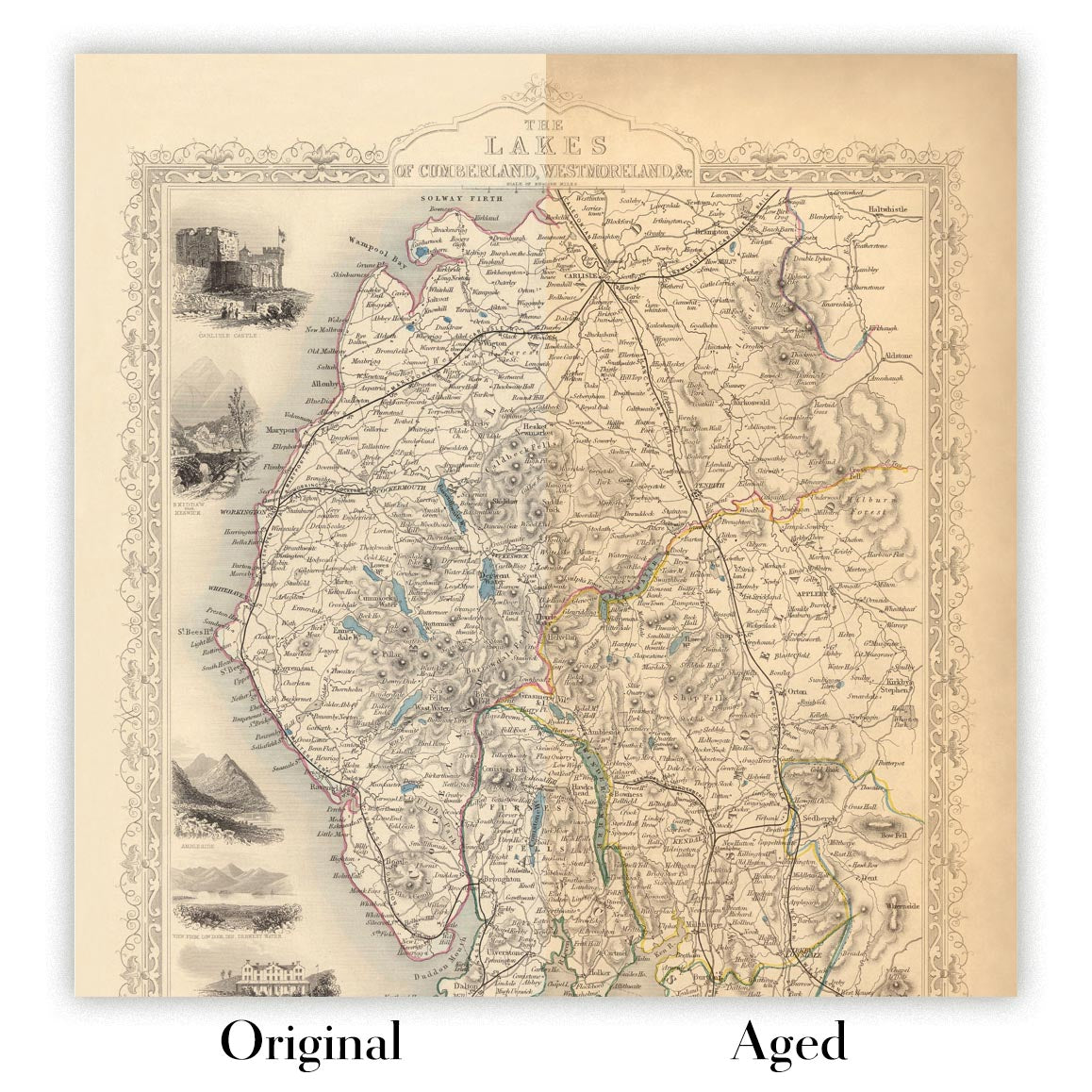
Map ageing
I have been asked hundreds of times over the years by customers if they could buy a map that looks even older.
Well, now you can, by selecting Aged before you add a map to your basket.
All the product photos you see on this page show the map in its Original form. This is what the map looks like today.
If you select Aged, I will age your map by hand, using a special and unique process developed through years of studying old maps, talking to researchers to understand the chemistry of aging paper, and of course... lots of practice!
If you're unsure, stick to the Original colour of the map. If you want something a bit darker and older looking, go for Aged.
If you are not happy with your order for any reason, contact me and I'll get it fixed ASAP, free of charge. Please see my returns and refund policy for more information.
I am very confident you will like your restored map or art print. I have been doing this since 1984. I'm a 5-star Etsy seller. I have sold tens of thousands of maps and art prints and have over 5,000 real 5-star reviews. My work has been featured in interior design magazines, on the BBC, and on the walls of dozens of 5-star hotels.
I use a unique process to restore maps and artwork that is massively time consuming and labour intensive. Hunting down the original maps and illustrations can take months. I use state of the art and eye-wateringly expensive technology to scan and restore them. As a result, I guarantee my maps and art prints are a cut above the rest. I stand by my products and will always make sure you're 100% happy with what you receive.
Almost all of my maps and art prints look amazing at large sizes (200cm, 6.5ft+) and I can frame and deliver them to you as well, via special oversized courier. Contact me to discuss your specific needs.
Or try searching for something!


