

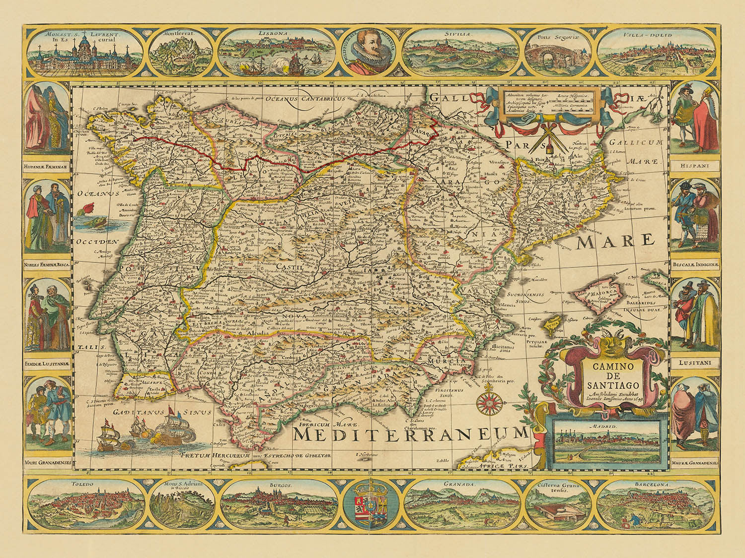


Rare Old Camino de Santiago Route Map by The Unique Maps Co & Jansson: Spain, Portugal, Pyrenees, Camino Francés
20% off 2 — 33% off 3
Add any two eligible items to your bag to receive 20% off. Add a third and it will be complimentary (equivalent to 33% off when purchasing three).
No code needed — the offer applies automatically at checkout.
Valid on all standard maps and fine art prints. You can mix and match any designs.
If you’d like to ship items to multiple addresses, please contact us before placing your order.
Custom and bespoke commissions are excluded.
Contact us if you have any questions
 Designed in London Made in the UK
Designed in London • Made in the UK
Designed in London Made in the UK
Designed in London • Made in the UK

Choose your size
Framing


(More info)
Gift message & custom finish

If you want to add a gift message, or a finish (jigsaw, aluminium board, etc.) that is not available here, please request it in the "order note" when you check out.
Every order is custom made, so if you need the size adjusted slightly, or printed on an unusual material, just let us know. We've done thousands of custom orders over the years, so there's (almost) nothing we can't manage.
You can also contact us before you order, if you prefer!

- Made locally for fast, safe delivery
- Free worldwide delivery, with no import duty surprises
- 90-day returns and 5-year guarantee
- Need advice? Message us on WhatsApp
Own a piece of history
7,000+ 5 star reviews


Step into the world of 17th-century cartography with the evocative “Camino de Santiago” map, originally crafted by the masterful Jan Jansson and reimagined by The Unique Maps Co. This remarkable piece, first published in 1659, elegantly charts the legendary Camino Francés pilgrimage route, winding from Saint-Jean-Pied-de-Port in France to the sacred city of Santiago de Compostela in Galicia, Spain. The route, highlighted in a striking red, draws the eye across the Iberian Peninsula, tracing the footsteps of countless pilgrims who have journeyed this path for centuries.
Jan Jansson, a towering figure of the Dutch Golden Age of cartography, was renowned for his meticulous attention to detail and his flair for decorative artistry. His maps are celebrated not only for their geographic accuracy but also for their ornate embellishments and period typography. This map stands as a testament to his legacy, offering a unique blend of political and physical geography—where borders, provinces, and natural features are rendered with both scientific precision and artistic grandeur.
The map’s design is a feast for the senses, featuring an ornate cartouche in the bottom right corner that frames the title in lavish baroque flourishes. Surrounding the main image, a decorative border and a compass rose evoke the spirit of adventure and discovery. The map vividly portrays the Pyrenees mountains, whose rugged peaks mark the border between France and Spain, and elegantly delineates the courses of major rivers such as the Ebro and Duero, which have shaped the landscape and history of the region.
Within its detailed expanse, the map brings to life a constellation of cities and towns that remain vibrant centers of culture and history today. From the bustling metropolis of Madrid and the cosmopolitan port of Barcelona to the storied cities of Pamplona, Burgos, León, and Santiago de Compostela, each settlement is meticulously labeled. In Portugal, the cities of Porto and Lisbon are depicted, underscoring the map’s comprehensive view of the Iberian Peninsula. The inclusion of Saint-Jean-Pied-de-Port in France, the traditional starting point of the Camino Francés, highlights the international significance of this ancient pilgrimage.
Beyond its aesthetic and historical allure, this map captures the enduring spiritual and cultural resonance of the Camino de Santiago. For centuries, pilgrims have traversed these mountains, valleys, and rivers, forging connections across borders and generations. Jan Jansson’s map not only guides the eye along the storied route but also invites the imagination to wander through the landscapes, landmarks, and histories that have defined the pilgrimage and the region itself. This is more than a map—it is a journey through time, art, and faith.
Cities and towns on this map
- Spain
- Madrid
- Barcelona
- Zaragoza
- Bilbao
- Valladolid
- Burgos
- León
- Logroño
- Pamplona
- Santiago de Compostela
- Astorga
- Ponferrada
- Portugal
- Porto (Oporto)
- Lisbon (Lisboa)
- France
- Saint-Jean-Pied-de-Port
Notable Features & Landmarks
- The Camino Francés pilgrimage route is marked in red, tracing its path across northern Spain.
- The Pyrenees mountain range, marking the border between France and Spain.
- Major rivers such as the Ebro and Duero.
- The Atlantic Ocean (Mar del Norte) and the Mediterranean Sea (Mare Mediterraneum).
- Ornate cartouche in the bottom right corner with the map’s title and decorative elements.
- Political borders between Spain and Portugal.
- Mountain ranges and hilly terrain illustrated with shaded relief.
- Decorative compass rose indicating cardinal directions.
- Decorative border around the map.
Historical and design context
- Based on an original map published by Jan Jansson in 1659, a renowned Dutch cartographer and publisher of the Dutch Golden Age.
- Contemporary creation by The Unique Maps Co., overlaying the Camino de Santiago pilgrimage route onto Jansson’s 17th-century map of Spain and Portugal.
- The main pilgrimage route shown is the Camino Francés (French Way), beginning in Saint-Jean-Pied-de-Port (France) and ending in Santiago de Compostela (Galicia, Spain).
- The map covers Spain and Portugal, including surrounding regions as depicted in the original 1659 map.
- Both political and physical features are shown, including borders, mountain ranges, rivers, and other geographical elements as known in the 17th century.
- The map’s style is decorative and historical, with elaborate border designs and period-accurate typography.
- Historical significance: The Camino de Santiago is one of the most important Christian pilgrimage routes in Europe, and Jan Jansson’s maps are valued for their historical accuracy and artistry.
Please double check the images to make sure that a specific town or place is shown on this map. You can also get in touch and ask us to check the map for you.
This map looks great at every size, but I always recommend going for a larger size if you have space. That way you can easily make out all of the details.
This map looks amazing at sizes all the way up to 90in (230cm). If you are looking for a larger map, please get in touch.
The model in the listing images is holding the 18x24in (45x60cm) version of this map.
The fifth listing image shows an example of my map personalisation service.
If you’re looking for something slightly different, check out my collection of the best old maps to see if something else catches your eye.
Please contact me to check if a certain location, landmark or feature is shown on this map.
This would make a wonderful birthday, Christmas, Father's Day, work leaving, anniversary or housewarming gift for someone from the areas covered by this map.
This map is available as a giclée print on acid free archival matte paper, or you can buy it framed. The frame is a nice, simple black frame that suits most aesthetics. Please get in touch if you'd like a different frame colour or material. My frames are glazed with super-clear museum-grade acrylic (perspex/acrylite), which is significantly less reflective than glass, safer, and will always arrive in perfect condition.
This map is also available as a float framed canvas, sometimes known as a shadow gap framed canvas or canvas floater. The map is printed on artist's cotton canvas and then stretched over a handmade box frame. We then "float" the canvas inside a wooden frame, which is available in a range of colours (black, dark brown, oak, antique gold and white). This is a wonderful way to present a map without glazing in front. See some examples of float framed canvas maps and explore the differences between my different finishes.
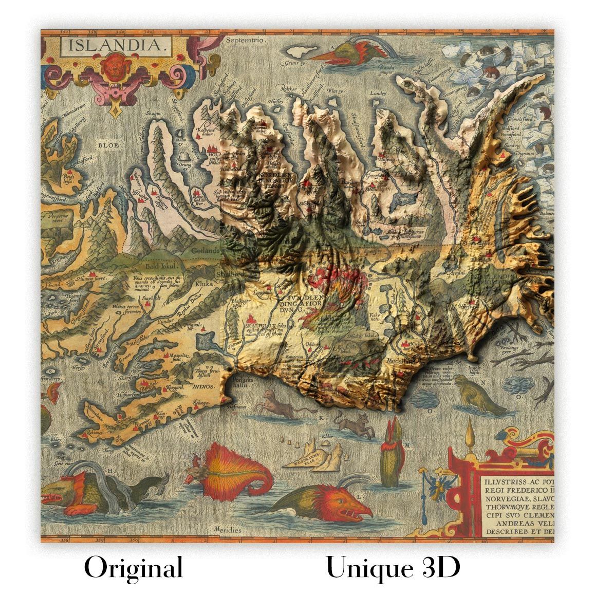
For something truly unique, this map is also available in "Unique 3D", our trademarked process that dramatically transforms the map so that it has a wonderful sense of depth. We combine the original map with detailed topography and elevation data, so that mountains and the terrain really "pop". For more info and examples of 3D maps, check my Unique 3D page.
Many of our maps and art prints are chosen as thoughtful gifts for homes, offices, studies and meaningful places.
Choose a framed option for the easiest ready-to-hang gift, or choose an unframed print if the recipient may prefer to select their own frame.
We make orders locally in 23 countries around the world, so gifts can often be produced close to the recipient. This helps them arrive faster, travel more safely, and avoid customs or import duty surprises.
- We can deliver directly to the recipient
- Framed pieces arrive ready to hang
- Unframed prints are carefully packed in a strong protective tube
- Almost every order is made locally, for faster, safer gifting
- 90-day returns give the recipient time to decide
If you are not sure what to choose, please contact us. We can help you pick the right map, size, finish or delivery option.
Most orders are made locally and delivered in around 2–3 working days, depending on the product, size and destination.
We print and frame maps and artwork in 23 countries around the world, so your order is usually made close to you or your recipient. That means faster delivery, less time in transit, and no customs or import duty surprises.
Personalised and customised pieces usually take an extra 1–2 working days, because we prepare your design and send it to you for approval before printing.
Very large framed orders can take a little longer, as they need extra care in production and delivery.
Every order is carefully packaged: unframed prints are sent in a strong protective tube, while framed pieces are securely packed with protective materials around the frame.
If you need your order by a particular date, please contact us before ordering. We’ll check the best production route and delivery option for your location.
Express delivery is available at checkout for most countries. Next-day delivery is available in the UK, US, Singapore and the UAE.
Your order is covered by our 90-day returns policy and 5-year guarantee.
My standard frame is a gallery style black ash hardwood frame. It is simple and quite modern looking. My standard frame is around 20mm (0.8in) wide.
I use super-clear acrylic (perspex/acrylite) for the frame glass. It's lighter and safer than glass - and it looks better, as the reflectivity is lower.
Six standard frame colours are available for free (black, dark brown, dark grey, oak, white and antique gold). Custom framing and mounting/matting is available if you're looking for something else.
Most maps, art and illustrations are also available as a framed canvas. We use matte (not shiny) cotton canvas, stretch it over a sustainably sourced box wood frame, and then 'float' the piece within a wood frame. The end result is quite beautiful, and there's no glazing to get in the way.
All frames are provided "ready to hang", with either a string or brackets on the back. Very large frames will have heavy duty hanging plates and/or a mounting baton. If you have any questions, please get in touch.
See some examples of my framed maps and framed canvas maps.
Alternatively, I can also supply old maps and artwork on canvas, foam board, cotton rag and other materials.
If you want to frame your map or artwork yourself, please read my size guide first.
My maps are extremely high quality reproductions of original maps.
I source original, rare maps from libraries, auction houses and private collections around the world, restore them at my London workshop, and then use specialist giclée inks and printers to create beautiful maps that look even better than the original.
My maps are printed on acid-free archival matte (not glossy) paper that feels very high quality and almost like card. In technical terms the paper weight/thickness is 10mil/200gsm. It's perfect for framing.
I print with Epson ultrachrome giclée UV fade resistant pigment inks - some of the best inks you can find.
I can also make maps on canvas, cotton rag and other exotic materials.
Learn more about The Unique Maps Co.
Map personalisation
If you're looking for the perfect anniversary or housewarming gift, I can personalise your map to make it truly unique. For example, I can add a short message, or highlight an important location, or add your family's coat of arms.
The options are almost infinite. Please see my map personalisation page for some wonderful examples of what's possible.
To order a personalised map, select "personalise your map" before adding it to your basket.
Get in touch if you're looking for more complex customisations and personalisations.
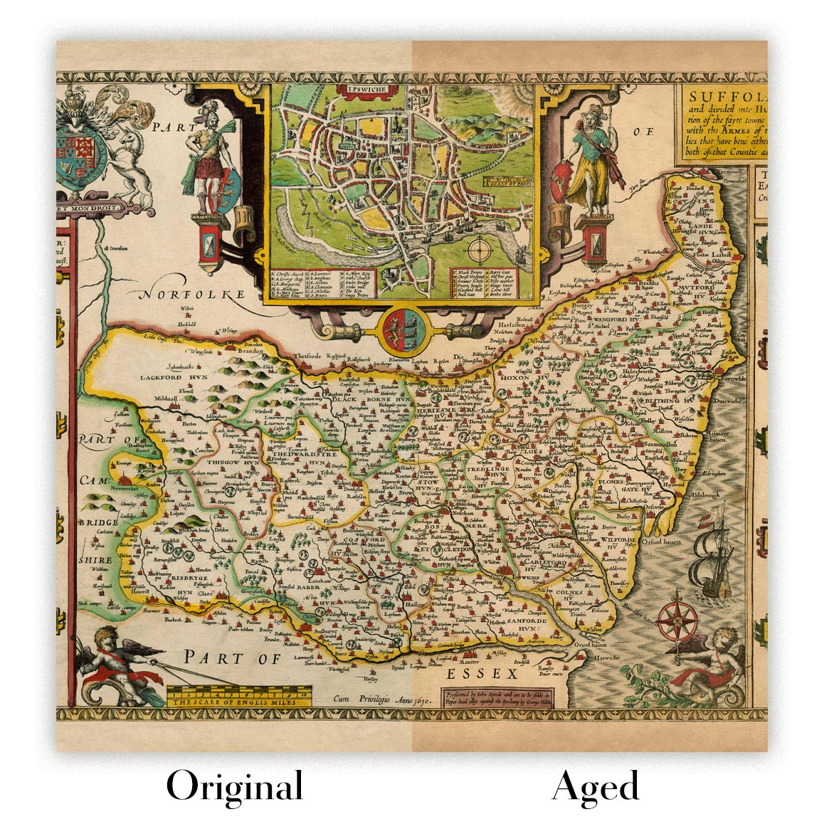
Map ageing
I have been asked hundreds of times over the years by customers if they could buy a map that looks even older.
Well, now you can, by selecting Aged before you add a map to your basket.
All the product photos you see on this page show the map in its Original form. This is what the map looks like today.
If you select Aged, I will age your map by hand, using a special and unique process developed through years of studying old maps, talking to researchers to understand the chemistry of aging paper, and of course... lots of practice!
If you're unsure, stick to the Original colour of the map. If you want something a bit darker and older looking, go for Aged.
If you are not happy with your order for any reason, contact me and I'll get it fixed ASAP, free of charge. Please see my returns and refund policy for more information.
I am very confident you will like your restored map or art print. I have been doing this since 1984. I'm a 5-star Etsy seller. I have sold tens of thousands of maps and art prints and have over 5,000 real 5-star reviews. My work has been featured in interior design magazines, on the BBC, and on the walls of dozens of 5-star hotels.
I use a unique process to restore maps and artwork that is massively time consuming and labour intensive. Hunting down the original maps and illustrations can take months. I use state of the art and eye-wateringly expensive technology to scan and restore them. As a result, I guarantee my maps and art prints are a cut above the rest. I stand by my products and will always make sure you're 100% happy with what you receive.
Almost all of my maps and art prints look amazing at large sizes (200cm, 6.5ft+) and I can frame and deliver them to you as well, via special oversized courier. Contact me to discuss your specific needs.
Or try searching for something!


