


Large Old Railway Map of India by Judd, 1890: Mumbai, Delhi, Kolkata, Ganges River, Himalayas
20% off 2 — 33% off 3
Add any two eligible items to your bag to receive 20% off. Add a third and it will be complimentary (equivalent to 33% off when purchasing three).
No code needed — the offer applies automatically at checkout.
Valid on all standard maps and fine art prints. You can mix and match any designs.
If you’d like to ship items to multiple addresses, please contact us before placing your order.
Custom and bespoke commissions are excluded.
Contact us if you have any questions
 Designed in London Made in the UK
Designed in London • Made in the UK
Designed in London Made in the UK
Designed in London • Made in the UK

Choose your size
Framing


(More info)
Gift message & custom finish

If you want to add a gift message, or a finish (jigsaw, aluminium board, etc.) that is not available here, please request it in the "order note" when you check out.
Every order is custom made, so if you need the size adjusted slightly, or printed on an unusual material, just let us know. We've done thousands of custom orders over the years, so there's (almost) nothing we can't manage.
You can also contact us before you order, if you prefer!

- Made locally for fast, safe delivery
- Free worldwide delivery, with no import duty surprises
- 90-day returns and 5-year guarantee
- Need advice? Message us on WhatsApp
Own a piece of history
7,000+ 5 star reviews


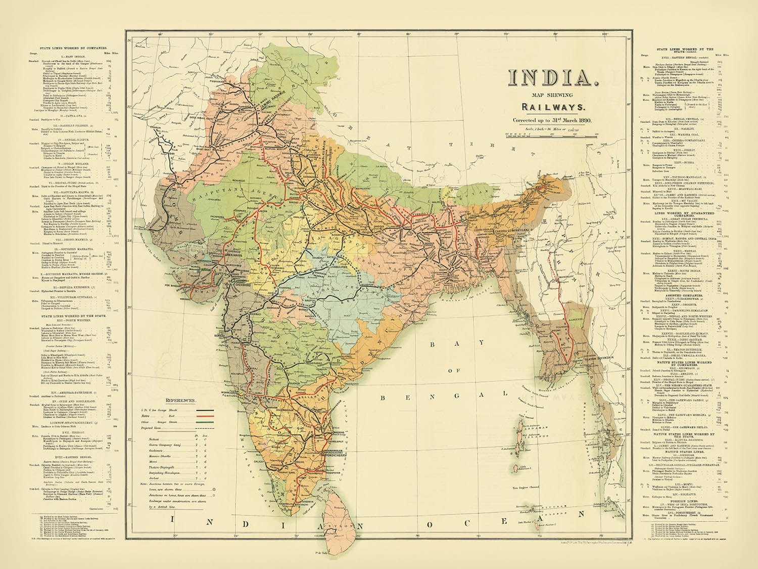
Step into the intricate world of late 19th-century South Asia with “India. Map Shewing Railways, corrected up to 31st March 1890,” a masterful cartographic achievement by the esteemed mapmaker Judd. This rare map captures the pulse of a continent in transformation, as British India’s burgeoning railway network reshaped the very fabric of society, commerce, and governance. Judd’s meticulous attention to detail and dedication to accuracy are evident in every line and legend, providing a snapshot of the subcontinent at a time when railways were not just tracks of steel, but arteries of empire.
Commissioned during a period of rapid infrastructural expansion, this map was created to document and celebrate the explosive growth of the Indian railway system. The British colonial administration saw the railway as both a symbol and a tool of their dominion, facilitating the movement of troops, goods, and ideas across vast and varied terrains. Judd’s work elegantly differentiates between broad, metre, and narrow gauge lines, using a sophisticated color-coding system to guide the viewer through the complexities of the network. Projected lines and railways under construction are also clearly indicated, offering a glimpse into the ambitions and priorities of the era.
Beyond its technical brilliance, the map is a visual journey across the subcontinent’s diverse landscapes. The mighty Himalayas form a dramatic northern border, while the great rivers—the Ganges, Indus, and Brahmaputra—snake across the plains, nourishing the land and shaping civilizations. The Arabian Sea, Bay of Bengal, and Indian Ocean are rendered with clarity, anchoring the map’s coastal cities and bustling ports. Major waterways and mountain ranges are not mere backdrops but essential elements in the story of the railway’s expansion, dictating routes and engineering marvels.
The map’s urban tapestry is equally compelling, featuring a constellation of cities and towns that would become some of the world’s great metropolises. Mumbai, Delhi, Kolkata, and Chennai are all prominently marked, alongside historic centers like Hyderabad, Jaipur, and Varanasi. Each city is a node in the network, connected by lines of commerce and culture. Notably, the map extends beyond present-day India, encompassing Karachi and Lahore (now in Pakistan), Dhaka and Chittagong (now in Bangladesh), and Rangoon (now Yangon, Myanmar), thus illustrating the reach and ambition of the colonial railway project.
Judd’s map is more than a utilitarian record; it is a work of art and a historical document of immense significance. It invites the viewer to contemplate the profound impact of the railways on the subcontinent’s economy, society, and identity. As you trace the routes across provinces, rivers, and borders, you are transported to an era when the clang of the locomotive echoed the ambitions of an empire and the hopes of a nation on the cusp of change. This map stands as a testament to the power of vision, engineering, and the enduring allure of exploration.
Cities and towns on this map
- India:
- Mumbai (Bombay)
- Delhi
- Kolkata (Calcutta)
- Chennai (Madras)
- Hyderabad
- Ahmedabad
- Pune (Poona)
- Surat
- Kanpur (Cawnpore)
- Lucknow
- Jaipur
- Nagpur
- Patna
- Agra
- Varanasi (Benares)
- Allahabad (Prayagraj)
-
Amritsar
-
Pakistan (modern-day):
- Karachi
- Lahore
- Multan
-
Peshawar
-
Bangladesh (modern-day):
- Dhaka
-
Chittagong
-
Myanmar (modern-day):
- Yangon (Rangoon)
- Mandalay
Notable Features & Landmarks
- Arabian Sea
- Bay of Bengal
- Indian Ocean
- Gulf of Mannar
- Ganges River
- Indus River
- Brahmaputra River
- Godavari River
- Krishna River
- Clearly marked borders of British India and neighboring territories, including Afghanistan, Nepal, Bhutan, Tibet, and Burma (Myanmar)
- Himalaya Mountains
Historical and design context
- Original title: "India. Map Shewing Railways, corrected up to 31st March 1890"
- Created by Judd in 1890, a noted mapmaker of the late 19th century
- The map illustrates the railway network in British India, distinguishing different railway gauges and showing projected lines
- Color-coded lines for broad, metre, and narrow gauge railways, with dashed lines for projected routes
- Commissioned during a period of rapid railway expansion under British colonial rule
- Covers the British Indian Empire, including modern-day India, Pakistan, Bangladesh, Myanmar, and neighboring regions
- Serves as a historical document of British colonial infrastructure, economic policy, and administrative control
- Highlights the impact of railways on trade, movement, and the spread of ideas across the subcontinent
Please double check the images to make sure that a specific town or place is shown on this map. You can also get in touch and ask us to check the map for you.
This map looks great at every size, but I always recommend going for a larger size if you have space. That way you can easily make out all of the details.
This map looks amazing at sizes all the way up to 100in (250cm). If you are looking for a larger map, please get in touch.
Please note: the labels on this map are hard to read if you order a map that is 20in (50cm) or smaller. The map is still very attractive, but if you would like to read the map easily, please buy a larger size.
The model in the listing images is holding the 18x24in (45x60cm) version of this map.
The fifth listing image shows an example of my map personalisation service.
If you’re looking for something slightly different, check out my collection of the best old maps to see if something else catches your eye.
Please contact me to check if a certain location, landmark or feature is shown on this map.
This would make a wonderful birthday, Christmas, Father's Day, work leaving, anniversary or housewarming gift for someone from the areas covered by this map.
This map is available as a giclée print on acid free archival matte paper, or you can buy it framed. The frame is a nice, simple black frame that suits most aesthetics. Please get in touch if you'd like a different frame colour or material. My frames are glazed with super-clear museum-grade acrylic (perspex/acrylite), which is significantly less reflective than glass, safer, and will always arrive in perfect condition.
This map is also available as a float framed canvas, sometimes known as a shadow gap framed canvas or canvas floater. The map is printed on artist's cotton canvas and then stretched over a handmade box frame. We then "float" the canvas inside a wooden frame, which is available in a range of colours (black, dark brown, oak, antique gold and white). This is a wonderful way to present a map without glazing in front. See some examples of float framed canvas maps and explore the differences between my different finishes.
For something truly unique, this map is also available in "Unique 3D", our trademarked process that dramatically transforms the map so that it has a wonderful sense of depth. We combine the original map with detailed topography and elevation data, so that mountains and the terrain really "pop". For more info and examples of 3D maps, check my Unique 3D page.
Many of our maps and art prints are chosen as thoughtful gifts for homes, offices, studies and meaningful places.
Choose a framed option for the easiest ready-to-hang gift, or choose an unframed print if the recipient may prefer to select their own frame.
We make orders locally in 23 countries around the world, so gifts can often be produced close to the recipient. This helps them arrive faster, travel more safely, and avoid customs or import duty surprises.
- We can deliver directly to the recipient
- Framed pieces arrive ready to hang
- Unframed prints are carefully packed in a strong protective tube
- Almost every order is made locally, for faster, safer gifting
- 90-day returns give the recipient time to decide
If you are not sure what to choose, please contact us. We can help you pick the right map, size, finish or delivery option.
Most orders are made locally and delivered in around 2–3 working days, depending on the product, size and destination.
We print and frame maps and artwork in 23 countries around the world, so your order is usually made close to you or your recipient. That means faster delivery, less time in transit, and no customs or import duty surprises.
Personalised and customised pieces usually take an extra 1–2 working days, because we prepare your design and send it to you for approval before printing.
Very large framed orders can take a little longer, as they need extra care in production and delivery.
Every order is carefully packaged: unframed prints are sent in a strong protective tube, while framed pieces are securely packed with protective materials around the frame.
If you need your order by a particular date, please contact us before ordering. We’ll check the best production route and delivery option for your location.
Express delivery is available at checkout for most countries. Next-day delivery is available in the UK, US, Singapore and the UAE.
Your order is covered by our 90-day returns policy and 5-year guarantee.
My standard frame is a gallery style black ash hardwood frame. It is simple and quite modern looking. My standard frame is around 20mm (0.8in) wide.
I use super-clear acrylic (perspex/acrylite) for the frame glass. It's lighter and safer than glass - and it looks better, as the reflectivity is lower.
Six standard frame colours are available for free (black, dark brown, dark grey, oak, white and antique gold). Custom framing and mounting/matting is available if you're looking for something else.
Most maps, art and illustrations are also available as a framed canvas. We use matte (not shiny) cotton canvas, stretch it over a sustainably sourced box wood frame, and then 'float' the piece within a wood frame. The end result is quite beautiful, and there's no glazing to get in the way.
All frames are provided "ready to hang", with either a string or brackets on the back. Very large frames will have heavy duty hanging plates and/or a mounting baton. If you have any questions, please get in touch.
See some examples of my framed maps and framed canvas maps.
Alternatively, I can also supply old maps and artwork on canvas, foam board, cotton rag and other materials.
If you want to frame your map or artwork yourself, please read my size guide first.
My maps are extremely high quality reproductions of original maps.
I source original, rare maps from libraries, auction houses and private collections around the world, restore them at my London workshop, and then use specialist giclée inks and printers to create beautiful maps that look even better than the original.
My maps are printed on acid-free archival matte (not glossy) paper that feels very high quality and almost like card. In technical terms the paper weight/thickness is 10mil/200gsm. It's perfect for framing.
I print with Epson ultrachrome giclée UV fade resistant pigment inks - some of the best inks you can find.
I can also make maps on canvas, cotton rag and other exotic materials.
Learn more about The Unique Maps Co.
Map personalisation
If you're looking for the perfect anniversary or housewarming gift, I can personalise your map to make it truly unique. For example, I can add a short message, or highlight an important location, or add your family's coat of arms.
The options are almost infinite. Please see my map personalisation page for some wonderful examples of what's possible.
To order a personalised map, select "personalise your map" before adding it to your basket.
Get in touch if you're looking for more complex customisations and personalisations.
Map ageing
I have been asked hundreds of times over the years by customers if they could buy a map that looks even older.
Well, now you can, by selecting Aged before you add a map to your basket.
All the product photos you see on this page show the map in its Original form. This is what the map looks like today.
If you select Aged, I will age your map by hand, using a special and unique process developed through years of studying old maps, talking to researchers to understand the chemistry of aging paper, and of course... lots of practice!
If you're unsure, stick to the Original colour of the map. If you want something a bit darker and older looking, go for Aged.
If you are not happy with your order for any reason, contact me and I'll get it fixed ASAP, free of charge. Please see my returns and refund policy for more information.
I am very confident you will like your restored map or art print. I have been doing this since 1984. I'm a 5-star Etsy seller. I have sold tens of thousands of maps and art prints and have over 5,000 real 5-star reviews. My work has been featured in interior design magazines, on the BBC, and on the walls of dozens of 5-star hotels.
I use a unique process to restore maps and artwork that is massively time consuming and labour intensive. Hunting down the original maps and illustrations can take months. I use state of the art and eye-wateringly expensive technology to scan and restore them. As a result, I guarantee my maps and art prints are a cut above the rest. I stand by my products and will always make sure you're 100% happy with what you receive.
Almost all of my maps and art prints look amazing at large sizes (200cm, 6.5ft+) and I can frame and deliver them to you as well, via special oversized courier. Contact me to discuss your specific needs.
Or try searching for something!


