


Ancienne carte des forêts et des parcs nationaux dans l'ouest des États-Unis par l'USGS, 1900: Yellowstone, Sierra Nevada, etc.
L’offre du collectionneur
Choisissez deux œuvres éligibles et bénéficiez de 20 % de réduction sur les deux. Choisissez-en trois et celle au prix le plus bas est offerte, pour une économie maximale de 33 %.
Associez librement des cartes standard éligibles et des tirages d’art. Aucun code n’est requis ; l’offre est appliquée automatiquement lors du paiement.
Les configurations standard réalisées sur commande sont incluses. Les formats sur mesure, les créations personnalisées et les œuvres commissionnées sont exclus.
Besoin d’une livraison à différentes adresses ? Contactez-nous avant de commander.L’offre du collectionneur
Choisissez deux œuvres éligibles et bénéficiez de 20 % de réduction sur les deux. Choisissez-en trois et celle au prix le plus bas est offerte, pour une économie maximale de 33 %.
Associez librement des cartes standard éligibles et des tirages d’art. Aucun code n’est requis ; l’offre est appliquée automatiquement lors du paiement.
Les configurations standard réalisées sur commande sont incluses. Les formats sur mesure, les créations personnalisées et les œuvres commissionnées sont exclus.
Besoin d’une livraison à différentes adresses ? Contactez-nous avant de commander. Restauré à Londres • Fabriqué en the UK

Restaurée à partir de la carte originale de 1900 et imprimée en qualité musée. Lire l’histoire de cette carte
Choose your size
Choose your finish


(Plus d’infos)
Message cadeau & finition personnalisée

Si vous souhaitez ajouter un message cadeau, ou une finition (puzzle, panneau en aluminium, etc.) qui n'est pas disponible ici, veuillez le demander dans la "note de commande" lors de votre passage à la caisse.
Chaque commande est fabriquée sur mesure, donc si vous avez besoin d'ajuster légèrement la taille, ou d'imprimer sur un matériau inhabituel, faites-le nous savoir. Nous avons réalisé des milliers de commandes personnalisées au fil des ans, donc il n'y a (presque) rien que nous ne puissions gérer.
Vous pouvez également nous contacter avant de passer votre commande, si vous le souhaitez !

- Fabriqué en the UK. Livraison sûre
- Livraison le lendemain disponible
- Besoin d’aide ? Appelez-nous ou message WhatsApp
Own a piece of history
8,000+ five-star reviews


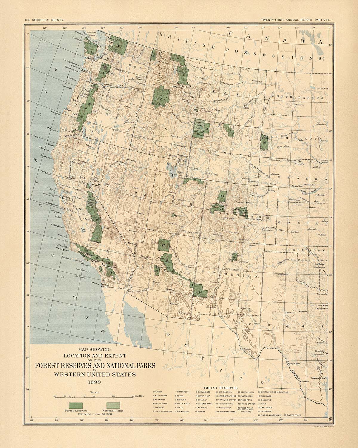
Entrez dans l'aube de la conservation américaine avec "Plaque I. Les réserves forestières et les parcs nationaux dans l'Ouest des États-Unis, 1899,"...
Continuer la lectureEntrez dans l'aube de la conservation américaine avec "Plaque I. Les réserves forestières et les parcs nationaux dans l'Ouest des États-Unis, 1899," une œuvre maîtresse de l'histoire cartographique réalisée par le vénérable US Geological Survey (USGS) en 1900. Cette carte est un témoignage visuel d'une époque charnière, lorsque les États-Unis ont commencé à se tourner vers la préservation de la grandeur sauvage de ses terres occidentales. Le titre original de la carte évoque à lui seul l'ambition et la vision de l'époque, alors qu'il cartographie méticuleusement les parcs nationaux et les réserves forestières nouvellement établis à l'ouest du 97e méridien. C'était un moment où les frontières entre la nature sauvage et la civilisation étaient encore en cours de négociation, et les contours du paysage américain étaient formellement inscrits pour la toute première fois.
L'USGS, établi en 1879, était à l'avant-garde de cette tâche monumentale, apportant rigueur scientifique et précision artistique à la cartographie des régions naturelles les plus précieuses de la nation. Leur expertise est évidente dans l'utilisation élégante des lignes de contour et des subtiles dégradés de couleurs, qui ensemble donnent vie au relief accidenté de la Sierra Nevada, de la chaîne des Cascades et des montagnes Rocheuses. Chaque détail, de la délimitation des frontières des États à l'ombrage soigné des terres protégées, reflète l'engagement double du Survey envers l'exactitude et la beauté. Cette carte n'est pas seulement un outil de navigation mais une œuvre d'art, capturant l'interaction de la géographie, de la politique et de la merveille naturelle au tournant du 20e siècle.
Le focus thématique de la carte est à la fois opportun et visionnaire. Au cœur se trouvent les grands parcs nationaux et les réserves forestières—Yellowstone, Lewis et Clarke, Mont Rainier, Olympic, chaîne des Cascades, Stanislaus et lac Tahoe—chacun délimité avec audace comme des phares du mouvement de conservation naissant. Ces zones protégées, mises en évidence par des couleurs distinctes, contrastent avec les terres environnantes non réservées, soulignant l'engagement fédéral précoce à protéger les forêts et les bassins versants de l'Amérique. La carte capture également l'ampleur des grandes chaînes de montagnes et les subtiles ondulations du paysage occidental, invitant le spectateur à tracer les chemins des rivières, suivre l'élévation des sommets et imaginer les forêts telles qu'elles étaient autrefois.
Au-delà de son attrait visuel, cette carte est une clé pour comprendre le contexte historique de la gestion des terres américaines. Publiée dans le cadre d'une collection monumentale de 711 pages, elle était accompagnée de rapports détaillés sur la classification des terres et l'état des ressources en bois, rédigés par certains des esprits scientifiques les plus éminents de l'époque. Ces documents offrent un aperçu des défis et des triomphes des premiers conservationnistes, dont les efforts ont jeté les bases des systèmes modernes de forêts nationales et de parcs nationaux. La carte elle-même sert donc à la fois de cliché d'un moment formateur et de référence pour quiconque s'intéresse à l'évolution de la politique environnementale américaine.
Ancrant la nature sauvage se trouvent les villes et villages en plein essor de l'Ouest—San Francisco, Los Angeles, Seattle, Denver, et d'autres—chacun étiqueté avec soin et situé contre l'immensité de leur environnement naturel. Ces établissements, aujourd'hui des métropoles, étaient alors des postes avancés à la lisière de l'inconnu, leurs fortunes étant étroitement liées au destin des forêts et des montagnes qui les entouraient. Cette juxtaposition de la civilisation et de la nature sauvage, rendue avec tant de compétence par l'USGS, fait de la carte un puissant artefact de l'identité américaine—un artefact qui parle de la tension durable entre développement et préservation, et de l'attrait intemporel de la frontière sauvage.
Villes et villages sur cette carte
- Californie:
- San Francisco
- Los Angeles
- San Diego
- Sacramento
- Washington:
- Seattle
- Spokane
- Tacoma
- Oregon:
- Portland
- Colorado:
- Denver
- Arizona:
- Phoenix
- Utah:
- Salt Lake City
Caractéristiques et monuments notables
- Les parcs nationaux sont clairement étiquetés et mis en évidence, y compris le parc national de Yellowstone.
- Les réserves forestières sont distinctement marquées, telles que:
- Réserve forestière Lewis et Clarke (Montana)
- Réserve forestière du mont Rainier (Washington)
- Réserve forestière olympique (Washington)
- Réserve forestière de la chaîne des Cascades (Oregon/Washington)
- Réserve forestière de Stanislaus (Californie)
- Réserve forestière du lac Tahoe (Californie/Nevada)
- Les frontières des États sont clairement délimitées.
- Les principales chaînes de montagnes, telles que la Sierra Nevada, la chaîne des Cascades et les montagnes Rocheuses, sont représentées avec des contours de relief.
- Le 97ème méridien ouest est marqué comme la frontière est de l'accent de la carte.
- Un ombrage coloré est utilisé pour différencier les réserves forestières et les parcs nationaux des autres terres.
Contexte historique et de conception
- Nom de la carte : Plaque I. Les réserves forestières et les parcs nationaux dans l'ouest des États-Unis, 1899.
- Date de création : Carte mise à jour au 30 juin 1900 ; publiée par le US Geological Survey (USGS) en 1900.
- Cartographe/éditeur : US Geological Survey (USGS), une agence scientifique fédérale établie en 1879, connue pour la cartographie et l'étude des ressources naturelles et des paysages des États-Unis.
- Couverture géographique : Se concentre sur l'ouest des États-Unis, en particulier les zones à l'ouest du 97ème méridien ouest, y compris des États tels que la Californie, l'Oregon, Washington, l'Idaho, le Montana, le Wyoming, le Colorado, l'Utah, l'Arizona et le Nouveau-Mexique.
- Type de carte : Carte thématique de comté ou d'État, mettant l'accent sur la gestion des terres et les thèmes de conservation.
- Principaux sujets et thèmes : Représente les parcs nationaux et les réserves forestières, soulignant les premiers efforts fédéraux de conservation et les classifications des terres au tournant du 20ème siècle.
- Conception/style : Le relief est montré à l'aide de lignes de contour et de couleurs, améliorant la visualisation des régions montagneuses et boisées.
- Importance historique : La carte fait partie d'une publication plus large (711 pages, 39 cartes) qui documente le développement précoce et la gestion des réserves forestières américaines, reflétant le mouvement croissant de conservation de l'époque.
- Importance contextuelle : Fournit un aperçu complet de la gestion des terres fédérales, des politiques de conservation et de la distribution géographique des zones protégées dans l'ouest des États-Unis vers 1900.
- Notable pour : Être une source primaire pour les historiens étudiant les origines des systèmes de forêts nationales et de parcs nationaux des États-Unis.
Veuillez vérifier les images pour vous assurer qu'une ville ou un endroit spécifique est montré sur cette carte. Vous pouvez également nous contacter et demander à vérifier la carte pour vous.
Cette carte est magnifique à toutes les tailles, mais je recommande toujours d'opter pour une taille plus grande si vous avez de l'espace. De cette façon, vous pouvez facilement distinguer tous les détails.
Cette carte est incroyable à des tailles allant jusqu'à 50 pouces (125 cm). Si vous recherchez une carte plus grande, veuillez nous contacter.
Le modèle sur les images de l'annonce tient la version 16x20in (40x50cm) de cette carte.
La cinquième image de la liste montre un exemple de mon service de personnalisation de carte.
Si vous cherchez quelque chose de légèrement différent, consultez ma collection des meilleures anciennes cartes pour voir si quelque chose d'autre attire votre attention.
Veuillez me contacter pour vérifier si un certain emplacement, un monument ou une caractéristique est représenté sur cette carte.
Cela ferait un merveilleux cadeau d'anniversaire, de Noël, pour la fête des pères, pour un départ au travail, un anniversaire de mariage ou une pendaison de crémaillère pour quelqu'un des zones couvertes par cette carte.
Cette carte est disponible en tant qu'impression giclée sur papier mat d'archivage sans acide, ou vous pouvez l'acheter encadrée. Le cadre est un joli cadre noir simple qui convient à la plupart des esthétiques. Veuillez me contacter si vous souhaitez une couleur ou un matériau de cadre différent. Mes cadres sont vitrées avec un acrylique de musée super clair (perspex/acrylite), qui est significativement moins réfléchissant que le verre, plus sûr, et arrivera toujours en parfait état.
This map is also available as a float framed canvas, sometimes known as a shadow gap framed canvas or canvas floater. The map is printed on artist's cotton canvas and then stretched over a handmade box frame. We then "float" the canvas inside a wooden frame, which is available in a range of colours (black, dark brown, oak, antique gold and white). This is a wonderful way to present a map without glazing in front. See some examples of float framed canvas maps and explore the differences between my different finishes.
For something truly unique, this map is also available in "Unique 3D", our trademarked process that dramatically transforms the map so that it has a wonderful sense of depth. We combine the original map with detailed topography and elevation data, so that mountains and the terrain really "pop". For more info and examples of 3D maps, check my Unique 3D page.
Entrez dans l'aube de la conservation américaine avec "Plaque I. Les réserves forestières et les parcs nationaux dans l'Ouest des États-Unis, 1899," une œuvre maîtresse de l'histoire cartographique réalisée par le vénérable US Geological Survey (USGS) en 1900. Cette carte est un témoignage visuel d'une époque charnière, lorsque les États-Unis ont commencé à se tourner vers la préservation de la grandeur sauvage de ses terres occidentales. Le titre original de la carte évoque à lui seul l'ambition et la vision de l'époque, alors qu'il cartographie méticuleusement les parcs nationaux et les réserves forestières nouvellement établis à l'ouest du 97e méridien. C'était un moment où les frontières entre la nature sauvage et la civilisation étaient encore en cours de négociation, et les contours du paysage américain étaient formellement inscrits pour la toute première fois.
L'USGS, établi en 1879, était à l'avant-garde de cette tâche monumentale, apportant rigueur scientifique et précision artistique à la cartographie des régions naturelles les plus précieuses de la nation. Leur expertise est évidente dans l'utilisation élégante des lignes de contour et des subtiles dégradés de couleurs, qui ensemble donnent vie au relief accidenté de la Sierra Nevada, de la chaîne des Cascades et des montagnes Rocheuses. Chaque détail, de la délimitation des frontières des États à l'ombrage soigné des terres protégées, reflète l'engagement double du Survey envers l'exactitude et la beauté. Cette carte n'est pas seulement un outil de navigation mais une œuvre d'art, capturant l'interaction de la géographie, de la politique et de la merveille naturelle au tournant du 20e siècle.
Le focus thématique de la carte est à la fois opportun et visionnaire. Au cœur se trouvent les grands parcs nationaux et les réserves forestières—Yellowstone, Lewis et Clarke, Mont Rainier, Olympic, chaîne des Cascades, Stanislaus et lac Tahoe—chacun délimité avec audace comme des phares du mouvement de conservation naissant. Ces zones protégées, mises en évidence par des couleurs distinctes, contrastent avec les terres environnantes non réservées, soulignant l'engagement fédéral précoce à protéger les forêts et les bassins versants de l'Amérique. La carte capture également l'ampleur des grandes chaînes de montagnes et les subtiles ondulations du paysage occidental, invitant le spectateur à tracer les chemins des rivières, suivre l'élévation des sommets et imaginer les forêts telles qu'elles étaient autrefois.
Au-delà de son attrait visuel, cette carte est une clé pour comprendre le contexte historique de la gestion des terres américaines. Publiée dans le cadre d'une collection monumentale de 711 pages, elle était accompagnée de rapports détaillés sur la classification des terres et l'état des ressources en bois, rédigés par certains des esprits scientifiques les plus éminents de l'époque. Ces documents offrent un aperçu des défis et des triomphes des premiers conservationnistes, dont les efforts ont jeté les bases des systèmes modernes de forêts nationales et de parcs nationaux. La carte elle-même sert donc à la fois de cliché d'un moment formateur et de référence pour quiconque s'intéresse à l'évolution de la politique environnementale américaine.
Ancrant la nature sauvage se trouvent les villes et villages en plein essor de l'Ouest—San Francisco, Los Angeles, Seattle, Denver, et d'autres—chacun étiqueté avec soin et situé contre l'immensité de leur environnement naturel. Ces établissements, aujourd'hui des métropoles, étaient alors des postes avancés à la lisière de l'inconnu, leurs fortunes étant étroitement liées au destin des forêts et des montagnes qui les entouraient. Cette juxtaposition de la civilisation et de la nature sauvage, rendue avec tant de compétence par l'USGS, fait de la carte un puissant artefact de l'identité américaine—un artefact qui parle de la tension durable entre développement et préservation, et de l'attrait intemporel de la frontière sauvage.
Villes et villages sur cette carte
- Californie:
- San Francisco
- Los Angeles
- San Diego
- Sacramento
- Washington:
- Seattle
- Spokane
- Tacoma
- Oregon:
- Portland
- Colorado:
- Denver
- Arizona:
- Phoenix
- Utah:
- Salt Lake City
Caractéristiques et monuments notables
- Les parcs nationaux sont clairement étiquetés et mis en évidence, y compris le parc national de Yellowstone.
- Les réserves forestières sont distinctement marquées, telles que:
- Réserve forestière Lewis et Clarke (Montana)
- Réserve forestière du mont Rainier (Washington)
- Réserve forestière olympique (Washington)
- Réserve forestière de la chaîne des Cascades (Oregon/Washington)
- Réserve forestière de Stanislaus (Californie)
- Réserve forestière du lac Tahoe (Californie/Nevada)
- Les frontières des États sont clairement délimitées.
- Les principales chaînes de montagnes, telles que la Sierra Nevada, la chaîne des Cascades et les montagnes Rocheuses, sont représentées avec des contours de relief.
- Le 97ème méridien ouest est marqué comme la frontière est de l'accent de la carte.
- Un ombrage coloré est utilisé pour différencier les réserves forestières et les parcs nationaux des autres terres.
Contexte historique et de conception
- Nom de la carte : Plaque I. Les réserves forestières et les parcs nationaux dans l'ouest des États-Unis, 1899.
- Date de création : Carte mise à jour au 30 juin 1900 ; publiée par le US Geological Survey (USGS) en 1900.
- Cartographe/éditeur : US Geological Survey (USGS), une agence scientifique fédérale établie en 1879, connue pour la cartographie et l'étude des ressources naturelles et des paysages des États-Unis.
- Couverture géographique : Se concentre sur l'ouest des États-Unis, en particulier les zones à l'ouest du 97ème méridien ouest, y compris des États tels que la Californie, l'Oregon, Washington, l'Idaho, le Montana, le Wyoming, le Colorado, l'Utah, l'Arizona et le Nouveau-Mexique.
- Type de carte : Carte thématique de comté ou d'État, mettant l'accent sur la gestion des terres et les thèmes de conservation.
- Principaux sujets et thèmes : Représente les parcs nationaux et les réserves forestières, soulignant les premiers efforts fédéraux de conservation et les classifications des terres au tournant du 20ème siècle.
- Conception/style : Le relief est montré à l'aide de lignes de contour et de couleurs, améliorant la visualisation des régions montagneuses et boisées.
- Importance historique : La carte fait partie d'une publication plus large (711 pages, 39 cartes) qui documente le développement précoce et la gestion des réserves forestières américaines, reflétant le mouvement croissant de conservation de l'époque.
- Importance contextuelle : Fournit un aperçu complet de la gestion des terres fédérales, des politiques de conservation et de la distribution géographique des zones protégées dans l'ouest des États-Unis vers 1900.
- Notable pour : Être une source primaire pour les historiens étudiant les origines des systèmes de forêts nationales et de parcs nationaux des États-Unis.
Veuillez vérifier les images pour vous assurer qu'une ville ou un endroit spécifique est montré sur cette carte. Vous pouvez également nous contacter et demander à vérifier la carte pour vous.
Cette carte est magnifique à toutes les tailles, mais je recommande toujours d'opter pour une taille plus grande si vous avez de l'espace. De cette façon, vous pouvez facilement distinguer tous les détails.
Cette carte est incroyable à des tailles allant jusqu'à 50 pouces (125 cm). Si vous recherchez une carte plus grande, veuillez nous contacter.
Le modèle sur les images de l'annonce tient la version 16x20in (40x50cm) de cette carte.
La cinquième image de la liste montre un exemple de mon service de personnalisation de carte.
Si vous cherchez quelque chose de légèrement différent, consultez ma collection des meilleures anciennes cartes pour voir si quelque chose d'autre attire votre attention.
Veuillez me contacter pour vérifier si un certain emplacement, un monument ou une caractéristique est représenté sur cette carte.
Cela ferait un merveilleux cadeau d'anniversaire, de Noël, pour la fête des pères, pour un départ au travail, un anniversaire de mariage ou une pendaison de crémaillère pour quelqu'un des zones couvertes par cette carte.
Cette carte est disponible en tant qu'impression giclée sur papier mat d'archivage sans acide, ou vous pouvez l'acheter encadrée. Le cadre est un joli cadre noir simple qui convient à la plupart des esthétiques. Veuillez me contacter si vous souhaitez une couleur ou un matériau de cadre différent. Mes cadres sont vitrées avec un acrylique de musée super clair (perspex/acrylite), qui est significativement moins réfléchissant que le verre, plus sûr, et arrivera toujours en parfait état.
This map is also available as a float framed canvas, sometimes known as a shadow gap framed canvas or canvas floater. The map is printed on artist's cotton canvas and then stretched over a handmade box frame. We then "float" the canvas inside a wooden frame, which is available in a range of colours (black, dark brown, oak, antique gold and white). This is a wonderful way to present a map without glazing in front. See some examples of float framed canvas maps and explore the differences between my different finishes.
For something truly unique, this map is also available in "Unique 3D", our trademarked process that dramatically transforms the map so that it has a wonderful sense of depth. We combine the original map with detailed topography and elevation data, so that mountains and the terrain really "pop". For more info and examples of 3D maps, check my Unique 3D page.
Many of our maps and art prints are chosen as thoughtful gifts for homes, offices, studies and meaningful places.
Choose a framed option for the easiest ready-to-hang gift, or choose an unframed print if the recipient may prefer to select their own frame.
We make orders locally in 23 countries around the world, so gifts can often be produced close to the recipient. This helps them arrive faster, travel more safely, and avoid customs or import duty surprises.
- We can deliver directly to the recipient
- Framed pieces arrive ready to hang
- Unframed prints are carefully packed in a strong protective tube
- Almost every order is made locally, for faster, safer gifting
- 90-day returns give the recipient time to decide
If you are not sure what to choose, please contact us. We can help you pick the right map, size, finish or delivery option.
Pour la plupart des commandes, le délai de livraison est d'environ 3 jours ouvrables. Les produits personnalisés et sur mesure prennent plus de temps, car je dois faire la personnalisation et vous l'envoyer pour approbation, ce qui prend généralement 1 ou 2 jours.
Veuillez noter que les grandes commandes encadrées prennent généralement plus de temps à réaliser et à livrer.
Si vous avez besoin que votre commande arrive à une date précise, veuillez me contacter avant de passer votre commande afin que nous puissions trouver le meilleur moyen de nous assurer que vous receviez votre commande à temps.
J'imprime et encadre des cartes et des œuvres d'art dans 23 pays à travers le monde. Cela signifie que votre commande sera réalisée localement, ce qui réduit le temps de livraison et garantit qu'elle ne sera pas endommagée pendant le transport. Vous ne paierez jamais de droits de douane ou d'importation, et nous mettrons moins de CO2 dans l'air.
Toutes mes cartes et impressions artistiques sont bien emballées et envoyées dans un tube robuste si non encadrées, ou entourées de mousse si encadrées.
J'essaie d'envoyer toutes les commandes dans les 1 ou 2 jours suivant la réception de votre commande, bien que certains produits (comme les masques, les mugs et les sacs fourre-tout) puissent prendre plus de temps à réaliser.
Si vous choisissez Livraison Express lors du paiement, nous donnerons la priorité à votre commande et l'enverrons par un service de messagerie de 1 jour (Fedex, DHL, UPS, Parcelforce).
La livraison le lendemain est également disponible dans certains pays (États-Unis, Royaume-Uni, Singapour, Émirats Arabes Unis), mais veuillez essayer de commander tôt dans la journée afin que nous puissions l'envoyer à temps.
Lisez mon guide complet sur la livraison et la production locale
Mon cadre standard est un cadre en bois dur noir de style galerie. Il est simple et a un aspect assez moderne. Mon cadre standard mesure environ 20 mm (0,8 po) de large.
J'utilise de l'acrylique super clair (perspex/acrylite) pour le verre du cadre. C'est plus léger et plus sûr que le verre - et cela a meilleur aspect, car la réflexivité est plus faible.
Six couleurs de cadre standard sont disponibles gratuitement (noir, marron foncé, gris foncé, chêne, blanc et or antique). Des encadrements et montages/matelassages personnalisés sont disponibles si vous recherchez autre chose.
La plupart des cartes, œuvres d'art et illustrations sont également disponibles sous forme de toile encadrée. Nous utilisons une toile en coton mate (non brillante), que nous tendons sur un cadre en bois de boîte provenant de sources durables, puis nous 'flottions' la pièce à l'intérieur d'un cadre en bois. Le résultat final est assez beau, et il n'y a pas de vitrage qui gêne.
Tous les cadres sont fournis "prêts à accrocher", avec soit une corde, soit des supports à l'arrière. Les très grands cadres auront des plaques de suspension lourdes et/ou une latte de montage. Si vous avez des questions, veuillez nous contacter.
Voir quelques exemples de mes cartes encadrées et de cartes en toile encadrées.
Alternativement, je peux également fournir de vieilles cartes et œuvres d'art sur toile, sur panneau en mousse, en coton et d'autres matériaux.
Si vous souhaitez encadrer votre carte ou œuvre d'art vous-même, veuillez lire d'abord mon guide des tailles.
Mes cartes sont des reproductions de cartes originales de très haute qualité.
Je recherche des cartes originales et rares auprès de bibliothèques, de maisons de ventes aux enchères et de collections privées du monde entier, je les restaure dans mon atelier de Londres, puis j'utilise des encres et des imprimantes giclées spécialisées pour créer de magnifiques cartes encore plus belles que l'originale.
Mes cartes sont imprimées sur du papier d’archives mat (non brillant) sans acide qui semble de très haute qualité et ressemble presque à une carte. En termes techniques, le grammage/épaisseur du papier est de 10 mil/200 g/m². C'est parfait pour l'encadrement.
J’imprime avec des encres pigmentaires Epson ultrachrome giclée UV résistantes à la décoloration – certaines des meilleures encres que vous puissiez trouver.
je peux aussi faire cartes sur toile, chiffon en coton et autres matériaux exotiques.
En savoir plus sur Unique Maps Co..
Personnalisation de la carte
Si vous recherchez le cadeau parfait pour un anniversaire ou une pendaison de crémaillère, je peux personnaliser votre carte pour la rendre vraiment unique. Par exemple, je peux ajouter un court message, mettre en évidence un lieu important ou ajouter les armoiries de votre famille.
Les options sont presque infinies. S'il vous plaît voir mon page de personnalisation de la carte pour quelques merveilleux exemples de ce qui est possible.
Pour commander une carte personnalisée, sélectionnez « personnaliser votre carte » avant de l'ajouter à votre panier.
Entrer en contact si vous recherchez des personnalisations et des personnalisations plus complexes.
Vieillissement de la carte
Au fil des ans, des clients m'ont demandé des centaines de fois s'ils pouvaient acheter une carte qui semble uniforme. plus vieux.
Eh bien, vous pouvez désormais le faire en sélectionnant Aged avant d'ajouter une carte à votre panier.
Toutes les photos de produits que vous voyez sur cette page montrent la carte dans sa forme originale. Voilà à quoi ressemble la carte aujourd'hui.
Si vous sélectionnez Vieilli, je vieillirai votre carte à la main, en utilisant un processus spécial et unique développé au cours d'années d'étude de cartes anciennes, de discussions avec des chercheurs pour comprendre la chimie du vieillissement du papier, et bien sûr... beaucoup de pratique !
Si vous n'êtes pas sûr, respectez la couleur originale de la carte. Si vous voulez quelque chose d'un peu plus sombre et plus vieux à la recherche, optez pour Aged.
Si vous n'êtes pas satisfait de votre commande pour une raison quelconque, contactez-moi pour un remboursement sans conditions. Veuillez consulter notre politique de retours et de remboursements pour plus d'informations.
Je suis très confiant que vous aimerez votre carte restaurée ou votre impression artistique. Je fais cela depuis 1984. Je suis un vendeur Etsy 5 étoiles. J'ai vendu des dizaines de milliers de cartes et d'impressions artistiques et j'ai plus de 5 000 vrais avis 5 étoiles.
J'utilise un processus unique pour restaurer des cartes et des œuvres d'art qui est extrêmement chronophage et exigeant en main-d'œuvre. Trouver les cartes et illustrations originales peut prendre des mois. J'utilise une technologie de pointe et incroyablement coûteuse pour les numériser et les restaurer. En conséquence, je garantis que mes cartes et impressions artistiques sont d'une qualité supérieure - c'est pourquoi je peux offrir un remboursement sans conditions.
Presque toutes mes cartes et impressions artistiques ont l'air incroyables en grandes tailles (200 cm, 6,5 pieds+) et je peux également les encadrer et vous les livrer, via un transporteur spécial surdimensionné. Contactez-moi pour discuter de vos besoins spécifiques.
Or try searching for something!


