


Rare Old Map of New South Wales and Victoria by Arrowsmith 1844: Sydney, Melbourne, Port Phillip, Bass Strait, routes 1817–40
Das Sammlerangebot
Wählen Sie zwei berechtigte Werke und erhalten Sie auf beide 20 % Rabatt. Wählen Sie drei, und das günstigste ist kostenlos – eine maximale Ersparnis von 33 %.
Kombinieren Sie berechtigte Standardkarten und Kunstdrucke nach Belieben. Kein Code erforderlich; das Angebot wird an der Kasse automatisch angewendet.
Standardmäßige Konfigurationen nach Maßanfertigung sind inbegriffen. Maßgeschneiderte Größen, personalisierte Entwürfe und Auftragsarbeiten sind ausgeschlossen.
Benötigen Sie die Lieferung an unterschiedliche Adressen? Kontaktieren Sie uns vor der Bestellung.Das Sammlerangebot
Wählen Sie zwei berechtigte Werke und erhalten Sie auf beide 20 % Rabatt. Wählen Sie drei, und das günstigste ist kostenlos – eine maximale Ersparnis von 33 %.
Kombinieren Sie berechtigte Standardkarten und Kunstdrucke nach Belieben. Kein Code erforderlich; das Angebot wird an der Kasse automatisch angewendet.
Standardmäßige Konfigurationen nach Maßanfertigung sind inbegriffen. Maßgeschneiderte Größen, personalisierte Entwürfe und Auftragsarbeiten sind ausgeschlossen.
Benötigen Sie die Lieferung an unterschiedliche Adressen? Kontaktieren Sie uns vor der Bestellung. In London gestaltet Hergestellt in the UK
In London gestaltet • Hergestellt in the UK
In London gestaltet Hergestellt in the UK
In London gestaltet • Hergestellt in the UK

Aus der Originalkarte von 1844 restauriert und in Museumsqualität gedruckt. Die Geschichte hinter dieser Karte lesen
Choose your size
Choose your finish


(Mehr Infos)
Geschenkmitteilung & individuelle Ausführung

Wenn Sie eine Geschenkmitteilung oder eine Ausführung (Puzzle, Aluminiumplatte usw.) hinzufügen möchten, die hier nicht verfügbar ist, geben Sie dies bitte in der "Bestellnotiz" beim Checkout an.
Jede Bestellung wird individuell angefertigt. Wenn Sie die Größe leicht anpassen oder auf einem ungewöhnlichen Material drucken lassen möchten, lassen Sie es uns einfach wissen. Wir haben im Laufe der Jahre Tausende von individuellen Bestellungen bearbeitet, daher gibt es (fast) nichts, was wir nicht bewältigen können.
Sie können uns auch kontaktieren, bevor Sie bestellen, wenn Sie möchten!

- Lokal gefertigt. Sicher geliefert
- Keine Zölle oder versteckten Gebühren
- Hilfe nötig? Rufen Sie uns an oder WhatsApp schreiben
Own a piece of history
8,000+ five-star reviews


South Eastern Portion of Australia, issued in 1844 by John Arrowsmith, captures a continent on the cusp of transformation with the cool...
WeiterlesenSouth Eastern Portion of Australia, issued in 1844 by John Arrowsmith, captures a continent on the cusp of transformation with the cool assurance of a master cartographer. The title signals his focus with unflinching precision: a judicious portrait of New South Wales and the Port Phillip District at a moment when counties, routes, and rivers were instruments of policy as much as geography. Arrowsmith’s signature outline color distinguishes counties and numbers them for swift reference, while a clear legend translates chromatic grace into practical intelligence. Issued amid the evolution of his celebrated atlas—whose expanded 1842 issue, with additional maps through 1844, is noted as an unrecorded variant by Verner, Phillips, and the British Museum—this map exemplifies the mid-century shift toward modern, information-rich design paired with spare, luminous elegance.
Arrowsmith’s design marries restraint with depth. Counties are washed in lucid tones and crisply numbered, their borders threaded across a terrain rendered through disciplined hachures that articulate the fall of land and the drama of elevation. Rivers are named with measured clarity—arteries that organize both settlement and imagination—while the great watershed of the interior is implied by the careful pull of tributaries running toward the south and west. Coastal forms are delineated with the delicacy of a draftsman: from the scalloped inlets around Port Jackson to the generous sweep of Port Phillip and the hard, oblique line of Bass Strait. The legend/key distills the visual system, allowing the viewer to navigate political divisions and physical geography with equal confidence.
The human geography is as telling as the physical. Sydney anchors the littoral world of New South Wales, its relationships to Newcastle and Wollongong traced along coast and river valleys that feed into the Hunter and Illawarra districts. Southward, in the Port Phillip District, Melbourne and Geelong appear as ascendant colonial towns, set against the estuarine breadth of Port Phillip and the lattice of rivers that would power trade and pastoral expansion. The counties that frame them—meticulously differentiated and cross-referenced—suggest a colonial order being mapped into existence. Roads and tracks are implied by alignments of settlement, ferries, and ports, while hinterlands begin to resolve into recognizable districts: places where naming, measuring, and jurisdiction were precursors to governance and commerce.
Perhaps the most evocative threads on the sheet are the routes of travelers into the interior, spanning 1817 to 1840. These lines press westward over the ranges and south across the plains, each bearing dates and directional cues that tether story to space. They record the audacity and contingency of exploration—episodic, cumulative, and often indebted to Aboriginal knowledge—linking coast to interior through a sequence of trials, river crossings, and passes. In frontier districts, Arrowsmith observes varying topographic textures and, where contemporary sources allowed, acknowledges cultural or territorial notes that shadow the colonial grid. The map becomes a palimpsest: the stable geometry of counties overlaying the more fluid itineraries of discovery that preceded them.
John Arrowsmith’s authority radiates from every decision. Nephew and heir to the Arrowsmith cartographic legacy, he drew upon Admiralty surveys, colonial dispatches, and explorers’ journals to synthesize the most reliable portrait available to London and the world. This 1844 sheet embodies the exploratory spirit and the administrative momentum of the nineteenth century: lucid in design, scrupulous in compilation, and forward-looking in its embrace of standardized color and intelligible referencing. It sits within an atlas program that, by the mid-1840s, had grown beyond its 1842 contours—adding fifteen new maps, including the scarce 1843 Texas—and now recognized by leading bibliographers as an unrecorded variant. For the discerning collector, it is a work of clarity and consequence: elegant, exacting, and historically resonant.
Cities and towns on this map
- Sydney (modern-day population: 5.3 million)
- Newcastle (modern-day population: 322,000)
- Wollongong (modern-day population: 300,000)
- Melbourne (modern-day population: 5 million)
- Geelong (modern-day population: 250,000)
Notable Features & Landmarks
- Detailed outlines of terrain and physical geographic features (e.g., mountains, rivers)
- Color-coded counties, each numbered for easy reference
- A detailed legend/key explaining color distinctions
- Routes of travelers into the interior clearly marked
- Notable rivers and lakes named and located
- Indication of indigenous territories or notable tribal regions (if applicable)
- Markings of exploratory expeditions conducted prior to 1840
- Areas depicted with varying topographic features
Historical and design context
- Date created: 1844
- Mapmaker: John Arrowsmith, a noted cartographer known for his accurate maps and innovative designs, which contributed significantly to cartography during the 19th century.
- This atlas is an exemplary piece reflecting elegance and clarity, marking a shift to modern atlas design in the 19th century.
- The 1842 edition includes an additional fifteen maps, including a rare Map of Texas from 1843 and several maps dated 1844; it’s noted as an unrecorded edition in Verner, Phillips, and the British Museum.
- Design/style context: The outline color design with differentiated counties enhances both the aesthetic and functional aspects of the map, making it an educational tool.
- Historical significance: This map exemplifies the exploratory spirit of the 19th century and reflects the colonial endeavors in Australia during a pivotal period of its development.
Please double check the images to make sure that a specific town or place is shown on this map. You can also get in touch and ask us to check the map for you.
This map looks great at every size, but I always recommend going for a larger size if you have space. That way you can easily make out all of the details.
This map looks amazing at sizes all the way up to 70in (180cm). If you are looking for a larger map, please get in touch.
Please note: the labels on this map are hard to read if you order a map that is 20in (50cm) or smaller. The map is still very attractive, but if you would like to read the map easily, please buy a larger size.
The model in the listing images is holding the 16x20in (40x50cm) version of this map.
The fifth listing image shows an example of my map personalisation service.
If you’re looking for something slightly different, check out my collection of the best old maps to see if something else catches your eye.
Please contact me to check if a certain location, landmark or feature is shown on this map.
This would make a wonderful birthday, Christmas, Father's Day, work leaving, anniversary or housewarming gift for someone from the areas covered by this map.
This map is available as a giclée print on acid free archival matte paper, or you can buy it framed. The frame is a nice, simple black frame that suits most aesthetics. Please get in touch if you'd like a different frame colour or material. My frames are glazed with super-clear museum-grade acrylic (perspex/acrylite), which is significantly less reflective than glass, safer, and will always arrive in perfect condition.
This map is also available as a float framed canvas, sometimes known as a shadow gap framed canvas or canvas floater. The map is printed on artist's cotton canvas and then stretched over a handmade box frame. We then "float" the canvas inside a wooden frame, which is available in a range of colours (black, dark brown, oak, antique gold and white). This is a wonderful way to present a map without glazing in front. See some examples of float framed canvas maps and explore the differences between my different finishes.
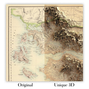
For something truly unique, this map is also available in "Unique 3D", our trademarked process that dramatically transforms the map so that it has a wonderful sense of depth. We combine the original map with detailed topography and elevation data, so that mountains and the terrain really "pop". For more info and examples of 3D maps, check my Unique 3D page.
South Eastern Portion of Australia, issued in 1844 by John Arrowsmith, captures a continent on the cusp of transformation with the cool assurance of a master cartographer. The title signals his focus with unflinching precision: a judicious portrait of New South Wales and the Port Phillip District at a moment when counties, routes, and rivers were instruments of policy as much as geography. Arrowsmith’s signature outline color distinguishes counties and numbers them for swift reference, while a clear legend translates chromatic grace into practical intelligence. Issued amid the evolution of his celebrated atlas—whose expanded 1842 issue, with additional maps through 1844, is noted as an unrecorded variant by Verner, Phillips, and the British Museum—this map exemplifies the mid-century shift toward modern, information-rich design paired with spare, luminous elegance.
Arrowsmith’s design marries restraint with depth. Counties are washed in lucid tones and crisply numbered, their borders threaded across a terrain rendered through disciplined hachures that articulate the fall of land and the drama of elevation. Rivers are named with measured clarity—arteries that organize both settlement and imagination—while the great watershed of the interior is implied by the careful pull of tributaries running toward the south and west. Coastal forms are delineated with the delicacy of a draftsman: from the scalloped inlets around Port Jackson to the generous sweep of Port Phillip and the hard, oblique line of Bass Strait. The legend/key distills the visual system, allowing the viewer to navigate political divisions and physical geography with equal confidence.
The human geography is as telling as the physical. Sydney anchors the littoral world of New South Wales, its relationships to Newcastle and Wollongong traced along coast and river valleys that feed into the Hunter and Illawarra districts. Southward, in the Port Phillip District, Melbourne and Geelong appear as ascendant colonial towns, set against the estuarine breadth of Port Phillip and the lattice of rivers that would power trade and pastoral expansion. The counties that frame them—meticulously differentiated and cross-referenced—suggest a colonial order being mapped into existence. Roads and tracks are implied by alignments of settlement, ferries, and ports, while hinterlands begin to resolve into recognizable districts: places where naming, measuring, and jurisdiction were precursors to governance and commerce.
Perhaps the most evocative threads on the sheet are the routes of travelers into the interior, spanning 1817 to 1840. These lines press westward over the ranges and south across the plains, each bearing dates and directional cues that tether story to space. They record the audacity and contingency of exploration—episodic, cumulative, and often indebted to Aboriginal knowledge—linking coast to interior through a sequence of trials, river crossings, and passes. In frontier districts, Arrowsmith observes varying topographic textures and, where contemporary sources allowed, acknowledges cultural or territorial notes that shadow the colonial grid. The map becomes a palimpsest: the stable geometry of counties overlaying the more fluid itineraries of discovery that preceded them.
John Arrowsmith’s authority radiates from every decision. Nephew and heir to the Arrowsmith cartographic legacy, he drew upon Admiralty surveys, colonial dispatches, and explorers’ journals to synthesize the most reliable portrait available to London and the world. This 1844 sheet embodies the exploratory spirit and the administrative momentum of the nineteenth century: lucid in design, scrupulous in compilation, and forward-looking in its embrace of standardized color and intelligible referencing. It sits within an atlas program that, by the mid-1840s, had grown beyond its 1842 contours—adding fifteen new maps, including the scarce 1843 Texas—and now recognized by leading bibliographers as an unrecorded variant. For the discerning collector, it is a work of clarity and consequence: elegant, exacting, and historically resonant.
Cities and towns on this map
- Sydney (modern-day population: 5.3 million)
- Newcastle (modern-day population: 322,000)
- Wollongong (modern-day population: 300,000)
- Melbourne (modern-day population: 5 million)
- Geelong (modern-day population: 250,000)
Notable Features & Landmarks
- Detailed outlines of terrain and physical geographic features (e.g., mountains, rivers)
- Color-coded counties, each numbered for easy reference
- A detailed legend/key explaining color distinctions
- Routes of travelers into the interior clearly marked
- Notable rivers and lakes named and located
- Indication of indigenous territories or notable tribal regions (if applicable)
- Markings of exploratory expeditions conducted prior to 1840
- Areas depicted with varying topographic features
Historical and design context
- Date created: 1844
- Mapmaker: John Arrowsmith, a noted cartographer known for his accurate maps and innovative designs, which contributed significantly to cartography during the 19th century.
- This atlas is an exemplary piece reflecting elegance and clarity, marking a shift to modern atlas design in the 19th century.
- The 1842 edition includes an additional fifteen maps, including a rare Map of Texas from 1843 and several maps dated 1844; it’s noted as an unrecorded edition in Verner, Phillips, and the British Museum.
- Design/style context: The outline color design with differentiated counties enhances both the aesthetic and functional aspects of the map, making it an educational tool.
- Historical significance: This map exemplifies the exploratory spirit of the 19th century and reflects the colonial endeavors in Australia during a pivotal period of its development.
Please double check the images to make sure that a specific town or place is shown on this map. You can also get in touch and ask us to check the map for you.
This map looks great at every size, but I always recommend going for a larger size if you have space. That way you can easily make out all of the details.
This map looks amazing at sizes all the way up to 70in (180cm). If you are looking for a larger map, please get in touch.
Please note: the labels on this map are hard to read if you order a map that is 20in (50cm) or smaller. The map is still very attractive, but if you would like to read the map easily, please buy a larger size.
The model in the listing images is holding the 16x20in (40x50cm) version of this map.
The fifth listing image shows an example of my map personalisation service.
If you’re looking for something slightly different, check out my collection of the best old maps to see if something else catches your eye.
Please contact me to check if a certain location, landmark or feature is shown on this map.
This would make a wonderful birthday, Christmas, Father's Day, work leaving, anniversary or housewarming gift for someone from the areas covered by this map.
This map is available as a giclée print on acid free archival matte paper, or you can buy it framed. The frame is a nice, simple black frame that suits most aesthetics. Please get in touch if you'd like a different frame colour or material. My frames are glazed with super-clear museum-grade acrylic (perspex/acrylite), which is significantly less reflective than glass, safer, and will always arrive in perfect condition.
This map is also available as a float framed canvas, sometimes known as a shadow gap framed canvas or canvas floater. The map is printed on artist's cotton canvas and then stretched over a handmade box frame. We then "float" the canvas inside a wooden frame, which is available in a range of colours (black, dark brown, oak, antique gold and white). This is a wonderful way to present a map without glazing in front. See some examples of float framed canvas maps and explore the differences between my different finishes.
For something truly unique, this map is also available in "Unique 3D", our trademarked process that dramatically transforms the map so that it has a wonderful sense of depth. We combine the original map with detailed topography and elevation data, so that mountains and the terrain really "pop". For more info and examples of 3D maps, check my Unique 3D page.
Many of our maps and art prints are chosen as thoughtful gifts for homes, offices, studies and meaningful places.
Choose a framed option for the easiest ready-to-hang gift, or choose an unframed print if the recipient may prefer to select their own frame.
We make orders locally in 23 countries around the world, so gifts can often be produced close to the recipient. This helps them arrive faster, travel more safely, and avoid customs or import duty surprises.
- We can deliver directly to the recipient
- Framed pieces arrive ready to hang
- Unframed prints are carefully packed in a strong protective tube
- Almost every order is made locally, for faster, safer gifting
- 90-day returns give the recipient time to decide
If you are not sure what to choose, please contact us. We can help you pick the right map, size, finish or delivery option.
Für die meisten Bestellungen beträgt die Lieferzeit etwa 3 Werktage. Personalisierte und maßgeschneiderte Produkte benötigen länger, da ich die Personalisierung durchführen und sie Ihnen zur Genehmigung zusenden muss, was normalerweise 1 oder 2 Tage dauert.
Bitte beachten Sie, dass sehr große gerahmte Bestellungen in der Regel länger für die Herstellung und Lieferung benötigen.
Wenn Sie möchten, dass Ihre Bestellung bis zu einem bestimmten Datum ankommt, bitte kontaktieren Sie mich, bevor Sie bestellen, damit wir den besten Weg finden können, um sicherzustellen, dass Sie Ihre Bestellung rechtzeitig erhalten.
Ich drucke und rahme Karten und Kunstwerke in 23 Ländern weltweit. Das bedeutet, dass Ihre Bestellung lokal gefertigt wird, was die Lieferzeit verkürzt und sicherstellt, dass sie während der Lieferung nicht beschädigt wird. Sie zahlen nie Zoll oder Einfuhrgebühren, und wir stoßen weniger CO2 in die Luft aus.
Alle meine Karten und Kunstdrucke sind gut verpackt und werden in einem robusten Rohr versendet, wenn sie ungerahmt sind, oder von Schaum umgeben, wenn sie gerahmt sind.
Ich versuche, alle Bestellungen innerhalb von 1 oder 2 Tagen nach Erhalt Ihrer Bestellung zu versenden, obwohl einige Produkte (wie Gesichtsmasken, Tassen und Tragetaschen) länger zur Herstellung benötigen können.
Wenn Sie Express-Lieferung an der Kasse auswählen, priorisieren wir Ihre Bestellung und versenden sie per 1-Tages-Kurier (Fedex, DHL, UPS, Parcelforce).
Nächster Tag Lieferung ist auch in einigen Ländern verfügbar (USA, UK, Singapur, VAE), aber bitte versuchen Sie, früh am Tag zu bestellen, damit wir es rechtzeitig versenden können.
Lesen Sie meinen vollständigen Leitfaden zur Lieferung und lokalen Produktion
Mein Standardrahmen ist ein Galerie-Stil-Rahmen aus schwarzem Eschenholz. Er ist einfach und sieht ziemlich modern aus. Mein Standardrahmen ist etwa 20 mm (0,8 Zoll) breit.
Ich verwende super-klares Acryl (Plexiglas/Acrylt) für das Glas des Rahmens. Es ist leichter und sicherer als Glas – und es sieht besser aus, da die Reflexion geringer ist.
Sechs Standardrahmenfarben sind kostenlos erhältlich (schwarz, dunkelbraun, dunkelgrau, Eiche, weiß und antikgold).
Die meisten Karten, Kunstwerke und Illustrationen sind auch als gerahmte Leinwand erhältlich. Wir verwenden matte (nicht glänzende) Baumwollleinwand, spannen sie über einen nachhaltig beschafften Buchenrahmen und 'schweben' dann das Stück innerhalb eines Holzrahmens. Das Endergebnis ist ziemlich schön, und es gibt keine Verglasung, die im Weg ist.
Alle Rahmen werden "bereit zum Aufhängen" geliefert, entweder mit einer Schnur oder Halterungen auf der Rückseite. Sehr große Rahmen haben schwere Aufhängeplatten und/oder eine Montageschiene. Wenn Sie Fragen haben, können Sie bitte Kontakt aufnehmen.
Sehen Sie sich einige Beispiele meiner gerahmten Karten und gerahmten Leinwandkarten an.
Alternativ kann ich auch alte Karten und Kunstwerke auf Leinwand, Schaumstoffplatten, Baumwollrag und andere Materialien liefern.
Wenn Sie Ihre Karte oder Ihr Kunstwerk selbst rahmen möchten, lesen Sie bitte zuerst meinen Größenleitfaden.
Meine Karten sind äußerst hochwertige Reproduktionen von Originalkarten.
Ich beziehe originale, seltene Karten aus Bibliotheken, Auktionshäusern und Privatsammlungen auf der ganzen Welt, restauriere sie in meiner Londoner Werkstatt und erstelle dann mit speziellen Giclée-Tinten und -Druckern wunderschöne Karten, die sogar noch besser aussehen als das Original.
Meine Karten werden auf säurefreiem, mattem Archivpapier (nicht glänzend) gedruckt, das sich sehr hochwertig anfühlt und fast wie Karton aussieht. Technisch gesehen beträgt das Papiergewicht/die Papierdicke 10mil/200g/m². Es eignet sich perfekt zum Einrahmen.
Ich drucke mit UV-lichtbeständigen Ultrachrome-Giclée-Pigmenttinten von Epson – einige der besten Tinten, die Sie finden können.
Ich kann auch machen Karten auf Leinwand, Baumwolllappen und andere exotische Materialien.
Erfahren Sie mehr über The Unique Maps Co.
Kartenpersonalisierung
Wenn Sie nach dem perfekten Geschenk zum Jahrestag oder zur Einweihung suchen, kann ich Ihre Karte personalisieren, um sie wirklich einzigartig zu machen. Ich kann beispielsweise eine kurze Nachricht hinzufügen, einen wichtigen Ort hervorheben oder das Wappen Ihrer Familie hinzufügen.
Die Möglichkeiten sind nahezu unbegrenzt. Bitte sehen Sie sich meine Kartenpersonalisierungsseite für einige wunderbare Beispiele dessen, was möglich ist.
Um eine personalisierte Karte zu bestellen, wählen Sie „Personalisieren Sie Ihre Karte“, bevor Sie sie in den Warenkorb legen.
In Kontakt kommen wenn Sie nach komplexeren Anpassungen und Personalisierungen suchen.
Kartenalterung
Im Laufe der Jahre wurde ich von Kunden hunderte Male gefragt, ob sie eine Karte kaufen könnten, die noch älter.
Nun, jetzt können Sie das, indem Sie „Alter“ auswählen, bevor Sie eine Karte in Ihren Warenkorb legen.
Alle Produktfotos, die Sie auf dieser Seite sehen, zeigen die Karte in ihrer Originalform. So sieht die Karte heute aus.
Wenn Sie „Gealtert“ auswählen, werde ich Ihre Karte von Hand altern lassen. Dazu verwende ich ein spezielles und einzigartiges Verfahren, das ich durch jahrelanges Studium alter Karten und Gespräche mit Forschern zum Verständnis der Chemie alternder Papiere entwickelt habe, und natürlich ... viel Übung!
Wenn Sie sich nicht sicher sind, bleiben Sie bei der Originalfarbe der Karte. Wenn Sie etwas Dunkleres und älter Wenn Sie auf der Suche sind, entscheiden Sie sich für „Aged“.
Sehen Sie einige erstaunliche Beispiele für gealterte Karten.
Wenn Sie aus irgendeinem Grund mit Ihrer Bestellung nicht zufrieden sind, kontaktieren Sie mich für eine unkomplizierte Rückerstattung. Bitte sehen Sie sich unsere Rückgabe- und Rückerstattungsrichtlinien für weitere Informationen an.
Ich bin sehr zuversichtlich, dass Ihnen Ihre restaurierte Karte oder Kunstdruck gefallen wird. Ich mache das seit 1984. Ich bin ein 5-Sterne Etsy-Verkäufer. Ich habe Zehntausende von Karten und Kunstdrucken verkauft und habe über 5.000 echte 5-Sterne-Bewertungen.
Ich verwende einen einzigartigen Prozess, um Karten und Kunstwerke zu restaurieren, der extrem zeitaufwendig und arbeitsintensiv ist. Die Suche nach den Originalkarten und Illustrationen kann Monate dauern. Ich benutze modernste und unglaublich teure Technologie, um sie zu scannen und wiederherzustellen. Daher garantiere ich, dass meine Karten und Kunstdrucke eine Klasse für sich sind - deshalb kann ich eine unkomplizierte Rückerstattung anbieten.
Fast alle meine Karten und Kunstdrucke sehen in großen Größen (200 cm, 6,5 Fuß+) erstaunlich aus und ich kann sie Ihnen auch gerahmt und über einen speziellen Übergrößen-Kurier liefern. Kontaktieren Sie mich, um Ihre speziellen Bedürfnisse zu besprechen.
Or try searching for something!


