


Alte Karte von "Französisch-Indien" von Vuillemin, 1869: Französische Enklaven, Pondicherry, Chandannagar, Mahé, Golf von Bengalen
20% Rabatt auf 2 — 33% Rabatt auf 3
Fügen Sie beliebige zwei berechtigte Artikel zu Ihrem Warenkorb hinzu, um 20% Rabatt zu erhalten. Fügen Sie einen dritten hinzu und er ist kostenlos (entspricht 33% Rabatt, wenn Sie drei kaufen).
Kein Code erforderlich — das Angebot wird automatisch an der Kasse angewendet.
Gültig für alle Standardkarten und Kunstdrucke. Sie können beliebige Designs kombinieren.
Wenn Sie Artikel an mehrere Adressen versenden möchten, kontaktieren Sie uns bitte, bevor Sie Ihre Bestellung aufgeben.
Maßanfertigungen und individuelle Aufträge sind ausgeschlossen.
Kontaktieren Sie uns wenn Sie Fragen haben
 In London gestaltet Hergestellt in the UK
In London gestaltet • Hergestellt in the UK
In London gestaltet Hergestellt in the UK
In London gestaltet • Hergestellt in the UK

Choose your size
Choose your finish


(Mehr Infos)
Geschenkmitteilung & individuelle Ausführung

Wenn Sie eine Geschenkmitteilung oder eine Ausführung (Puzzle, Aluminiumplatte usw.) hinzufügen möchten, die hier nicht verfügbar ist, geben Sie dies bitte in der "Bestellnotiz" beim Checkout an.
Jede Bestellung wird individuell angefertigt. Wenn Sie die Größe leicht anpassen oder auf einem ungewöhnlichen Material drucken lassen möchten, lassen Sie es uns einfach wissen. Wir haben im Laufe der Jahre Tausende von individuellen Bestellungen bearbeitet, daher gibt es (fast) nichts, was wir nicht bewältigen können.
Sie können uns auch kontaktieren, bevor Sie bestellen, wenn Sie möchten!

- Made locally for fast, safe delivery
- No import duty or hidden fees
- Need advice? Message us on WhatsApp
Own a piece of history
7,000+ 5 star reviews


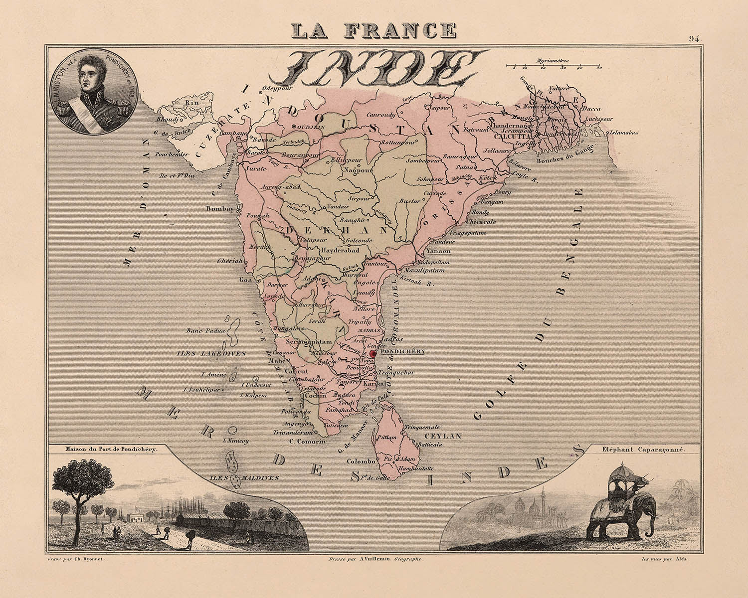
Betreten Sie die lebendige Welt der kolonialen Kartographie des 19. Jahrhunderts mit "Französisch-Indien", ursprünglich betitelt Inde la France, erstellt von dem angesehenen französischen Kartenmacher A. Vuillemin im Jahr 1869. Diese Karte ist ein Zeugnis für die künstlerischen und wissenschaftlichen Ambitionen ihrer Zeit und verbindet präzise geografische Details mit eindrucksvollen Vignetten, die das kulturelle und wirtschaftliche Gefüge der französischen Kolonien in Indien zum Leben erwecken. Vuillemins akribischer Ansatz zeigt sich in jedem Element, von der klaren Abgrenzung der französischen Gebiete bis hin zu den lebhaften Illustrationen, die die Karte umrahmen und den Betrachtern einen Einblick in die Landschaften und alltäglichen Rhythmen einer fernen kolonialen Welt bieten.
A. Vuillemin war bekannt für seine Fähigkeit, wissenschaftliche Kartographie mit künstlerischem Flair zu verbinden, und diese Karte ist ein typisches Beispiel seines Schaffens. Jede Region—Pondichéry, Karikal, Mahé, Yanaon und Chandernagor—wurde sorgfältig dargestellt, mit scharf definierten Grenzen, um die französische Präsenz im weiten britisch kontrollierten indischen Subkontinent hervorzuheben. Vuillemins Werk wird zudem durch die Einbeziehung lokaler Szenen, bemerkenswerter Persönlichkeiten und Wappen, die alle akribisch illustriert sind, um die einzigartige Identität jeder Enklave hervorzurufen, weiter ausgezeichnet. Seine Liebe zum Detail verbessert nicht nur die ästhetische Anziehungskraft der Karte, sondern dient auch als wertvolles historisches Dokument einer vergangenen Ära.
Die Kunstfertigkeit der Karte wird durch ihren reichen thematischen Inhalt ergänzt. Um die Hauptkartenpanels herum sind Vignetten abgebildet, die die Menschen, Pflanzen und Aktivitäten zeigen, die Französisch-Indien im 19. Jahrhundert prägten. Diese Illustrationen sind mehr als bloße Dekoration—sie sind Fenster in das soziale und wirtschaftliche Leben der Region, von geschäftigen Marktplätzen bis zu ruhigen Flussufern. Die Karte enthält auch informative Texte, die Statistiken und geografischen Kontext bieten, einschließlich der Entfernung und Richtung von Paris, wodurch diese fernen Kolonien in die breitere Erzählung des französischen imperialen Ehrgeizes eingeordnet werden.
Geografisch ist die Karte ein Meisterwerk in Präzision und Klarheit. Wichtige Gewässer wie die Bucht von Bengalen, das Arabische Meer und der Indische Ozean sind sorgfältig dargestellt, während Flüsse wie der Hooghly in der Nähe von Chandernagor der Komposition Tiefe und Realität verleihen. Die Küstenlinien und Flussverläufe sind nicht nur genau, sondern auch elegant in das Gesamtdesign der Karte integriert. Die Grenzen der französischen Territorien sind klar markiert, was einen auffälligen Kontrast zu den umliegenden Regionen bietet und die geopolitischen Komplexitäten des kolonialen Indiens unterstreicht.
Am überzeugendsten sind vielleicht die Städte und Orte, die diese Karte verankern—Puducherry (Pondichéry), Karaikal, Chandannagar, Yanam und Mahé. Jede Siedlung ist mit historischer Präzision markiert, was ihre Bedeutung als Zentrum der Verwaltung, des Handels und des kulturellen Austauschs widerspiegelt. Diese Enklaven, obwohl klein, spielten eine überproportionale Rolle in der Geschichte des Französischen Indiens und dienten als Tore für Handel und interkulturelle Interaktion. Durch Vuillemins geschickte Hand werden diese Orte lebendig und laden den Betrachter ein, nicht nur die Geographie, sondern die lebendige Geschichte eines einzigartigen Kapitels im kolonialen Zusammentreffen zwischen Frankreich und Indien zu erkunden.
Städte und Orte auf dieser Karte
- Puducherry (Pondichéry)
- Karaikal (Karikal)
- Chandannagar (Chandernagor)
- Yanam (Yanaon)
- Mahé
Bemerkenswerte Merkmale & Wahrzeichen
- Karte, die die einzelnen französischen Enklaven in Indien zeigt, einschließlich Pondichéry, Karikal, Mahé, Yanaon und Chandernagor
- Künstlerische Vignetten, die lokale Szenen, kulturelle Praktiken und menschliche Aktivitäten in den französischen Indienterritorien darstellen
- Darstellungen von Einheimischen in traditioneller Kleidung, die an täglichen Aktivitäten teilnehmen
- Bengalische Bucht
- Arabisches Meer
- Indischer Ozean
- Flüsse, die deutlich in der Nähe der Enklaven dargestellt sind, wie der Hooghly-Fluss in der Nähe von Chandernagor
- Deutlich abgegrenzte Grenzen der französischen Territorien, die sie von den umliegenden britisch kontrollierten Gebieten unterscheiden
- Prominente Küstenlinien und Flussverläufe
Historischer und gestalterischer Kontext
- Erstellt von A. Vuillemin, einem renommierten französischen Kartografen des 19. Jahrhunderts, bekannt dafür, wissenschaftliche Kartografie mit künstlerischem Flair zu kombinieren
- Produziert im Jahr 1869, das das Ausmaß und die Natur des französischen kolonialen Einflusses in Indien im späten 19. Jahrhundert widerspiegelt
- Teil einer Sammlung, die durch farbenfrohe künstlerische Karten gekennzeichnet ist, die mit Vignetten kombiniert sind, die lokale Szenen, bemerkenswerte Persönlichkeiten, Tiere, menschliche Aktivitäten, Pflanzen und Wappen illustrieren
- Jede Karte in der Sammlung wird von umfassenden Textinformationen begleitet, einschließlich Statistiken und geografischen Details wie Entfernungen und Richtungen von Paris
- Künstlerischer und dekorativer Stil, der typisch für die europäische Kartografie des 19. Jahrhunderts ist, und der geografische Genauigkeit mit kulturellem und historischem Kontext verbindet
- Bietet Einblicke in den europäischen Kolonialismus, Handel und kulturelle Interaktionen zwischen Frankreich und Indien zu dieser Zeit
Bitte überprüfen Sie die Bilder, um sicherzustellen, dass eine bestimmte Stadt oder ein Ort auf dieser Karte dargestellt ist. Sie können uns auch kontaktieren und uns bitten, die Karte für Sie zu überprüfen.
Diese Karte sieht in jeder Größe großartig aus, aber ich empfehle immer, eine größere Größe zu wählen, wenn Sie Platz haben. So können Sie alle Details leicht erkennen.
Diese Karte sieht bis zu 50 Zoll (125 cm) großartig aus. Wenn Sie nach einer größeren Karte suchen, bitte nehmen Sie Kontakt auf.
Das Modell in den Angebotsbildern hält die 16x20 Zoll (40x50 cm) Version dieser Karte.
Das fünfte Angebotsbild zeigt ein Beispiel für meinen Personalisierungsservice für Karten.
Wenn Sie nach etwas etwas anderem suchen, schauen Sie sich meine Sammlung der besten alten Karten an, um zu sehen, ob etwas anderes Ihr Interesse weckt.
Bitte kontaktieren Sie mich, um zu überprüfen, ob ein bestimmter Ort, ein Wahrzeichen oder ein Merkmal auf dieser Karte dargestellt ist.
Dies wäre ein wunderbares Geschenk zum Geburtstag, zu Weihnachten, zum Vatertag, zum Abschied von der Arbeit, zum Jubiläum oder zur Einweihung für jemanden aus den Gebieten, die von dieser Karte abgedeckt werden.
Diese Karte ist als Giclée-Druck auf säurefreiem, archiviertem mattem Papier erhältlich, oder Sie können sie gerahmt kaufen. Der Rahmen ist ein schöner, einfacher schwarzer Rahmen, der zu den meisten Ästhetiken passt. Bitte kontaktieren Sie mich, wenn Sie eine andere Rahmenfarbe oder -material wünschen. Meine Rahmen sind mit superklarem museumsgrauem Acryl (Plexiglas/Acrylt) verglast, das deutlich weniger reflektierend als Glas ist, sicherer und immer in perfektem Zustand ankommt.
This map is also available as a float framed canvas, sometimes known as a shadow gap framed canvas or canvas floater. The map is printed on artist's cotton canvas and then stretched over a handmade box frame. We then "float" the canvas inside a wooden frame, which is available in a range of colours (black, dark brown, oak, antique gold and white). This is a wonderful way to present a map without glazing in front. See some examples of float framed canvas maps and explore the differences between my different finishes.
For something truly unique, this map is also available in "Unique 3D", our trademarked process that dramatically transforms the map so that it has a wonderful sense of depth. We combine the original map with detailed topography and elevation data, so that mountains and the terrain really "pop". For more info and examples of 3D maps, check my Unique 3D page.
Many of our maps and art prints are chosen as thoughtful gifts for homes, offices, studies and meaningful places.
Choose a framed option for the easiest ready-to-hang gift, or choose an unframed print if the recipient may prefer to select their own frame.
We make orders locally in 23 countries around the world, so gifts can often be produced close to the recipient. This helps them arrive faster, travel more safely, and avoid customs or import duty surprises.
- We can deliver directly to the recipient
- Framed pieces arrive ready to hang
- Unframed prints are carefully packed in a strong protective tube
- Almost every order is made locally, for faster, safer gifting
- 90-day returns give the recipient time to decide
If you are not sure what to choose, please contact us. We can help you pick the right map, size, finish or delivery option.
Für die meisten Bestellungen beträgt die Lieferzeit etwa 3 Werktage. Personalisierte und maßgeschneiderte Produkte benötigen länger, da ich die Personalisierung durchführen und sie Ihnen zur Genehmigung zusenden muss, was normalerweise 1 oder 2 Tage dauert.
Bitte beachten Sie, dass sehr große gerahmte Bestellungen in der Regel länger für die Herstellung und Lieferung benötigen.
Wenn Sie möchten, dass Ihre Bestellung bis zu einem bestimmten Datum ankommt, bitte kontaktieren Sie mich, bevor Sie bestellen, damit wir den besten Weg finden können, um sicherzustellen, dass Sie Ihre Bestellung rechtzeitig erhalten.
Ich drucke und rahme Karten und Kunstwerke in 23 Ländern weltweit. Das bedeutet, dass Ihre Bestellung lokal gefertigt wird, was die Lieferzeit verkürzt und sicherstellt, dass sie während der Lieferung nicht beschädigt wird. Sie zahlen nie Zoll oder Einfuhrgebühren, und wir stoßen weniger CO2 in die Luft aus.
Alle meine Karten und Kunstdrucke sind gut verpackt und werden in einem robusten Rohr versendet, wenn sie ungerahmt sind, oder von Schaum umgeben, wenn sie gerahmt sind.
Ich versuche, alle Bestellungen innerhalb von 1 oder 2 Tagen nach Erhalt Ihrer Bestellung zu versenden, obwohl einige Produkte (wie Gesichtsmasken, Tassen und Tragetaschen) länger zur Herstellung benötigen können.
Wenn Sie Express-Lieferung an der Kasse auswählen, priorisieren wir Ihre Bestellung und versenden sie per 1-Tages-Kurier (Fedex, DHL, UPS, Parcelforce).
Nächster Tag Lieferung ist auch in einigen Ländern verfügbar (USA, UK, Singapur, VAE), aber bitte versuchen Sie, früh am Tag zu bestellen, damit wir es rechtzeitig versenden können.
Lesen Sie meinen vollständigen Leitfaden zur Lieferung und lokalen Produktion
Mein Standardrahmen ist ein Galerie-Stil-Rahmen aus schwarzem Eschenholz. Er ist einfach und sieht ziemlich modern aus. Mein Standardrahmen ist etwa 20 mm (0,8 Zoll) breit.
Ich verwende super-klares Acryl (Plexiglas/Acrylt) für das Glas des Rahmens. Es ist leichter und sicherer als Glas – und es sieht besser aus, da die Reflexion geringer ist.
Sechs Standardrahmenfarben sind kostenlos erhältlich (schwarz, dunkelbraun, dunkelgrau, Eiche, weiß und antikgold).
Die meisten Karten, Kunstwerke und Illustrationen sind auch als gerahmte Leinwand erhältlich. Wir verwenden matte (nicht glänzende) Baumwollleinwand, spannen sie über einen nachhaltig beschafften Buchenrahmen und 'schweben' dann das Stück innerhalb eines Holzrahmens. Das Endergebnis ist ziemlich schön, und es gibt keine Verglasung, die im Weg ist.
Alle Rahmen werden "bereit zum Aufhängen" geliefert, entweder mit einer Schnur oder Halterungen auf der Rückseite. Sehr große Rahmen haben schwere Aufhängeplatten und/oder eine Montageschiene. Wenn Sie Fragen haben, können Sie bitte Kontakt aufnehmen.
Sehen Sie sich einige Beispiele meiner gerahmten Karten und gerahmten Leinwandkarten an.
Alternativ kann ich auch alte Karten und Kunstwerke auf Leinwand, Schaumstoffplatten, Baumwollrag und andere Materialien liefern.
Wenn Sie Ihre Karte oder Ihr Kunstwerk selbst rahmen möchten, lesen Sie bitte zuerst meinen Größenleitfaden.
Meine Karten sind äußerst hochwertige Reproduktionen von Originalkarten.
Ich beziehe originale, seltene Karten aus Bibliotheken, Auktionshäusern und Privatsammlungen auf der ganzen Welt, restauriere sie in meiner Londoner Werkstatt und erstelle dann mit speziellen Giclée-Tinten und -Druckern wunderschöne Karten, die sogar noch besser aussehen als das Original.
Meine Karten werden auf säurefreiem, mattem Archivpapier (nicht glänzend) gedruckt, das sich sehr hochwertig anfühlt und fast wie Karton aussieht. Technisch gesehen beträgt das Papiergewicht/die Papierdicke 10mil/200g/m². Es eignet sich perfekt zum Einrahmen.
Ich drucke mit UV-lichtbeständigen Ultrachrome-Giclée-Pigmenttinten von Epson – einige der besten Tinten, die Sie finden können.
Ich kann auch machen Karten auf Leinwand, Baumwolllappen und andere exotische Materialien.
Erfahren Sie mehr über The Unique Maps Co.
Kartenpersonalisierung
Wenn Sie nach dem perfekten Geschenk zum Jahrestag oder zur Einweihung suchen, kann ich Ihre Karte personalisieren, um sie wirklich einzigartig zu machen. Ich kann beispielsweise eine kurze Nachricht hinzufügen, einen wichtigen Ort hervorheben oder das Wappen Ihrer Familie hinzufügen.
Die Möglichkeiten sind nahezu unbegrenzt. Bitte sehen Sie sich meine Kartenpersonalisierungsseite für einige wunderbare Beispiele dessen, was möglich ist.
Um eine personalisierte Karte zu bestellen, wählen Sie „Personalisieren Sie Ihre Karte“, bevor Sie sie in den Warenkorb legen.
In Kontakt kommen wenn Sie nach komplexeren Anpassungen und Personalisierungen suchen.
Kartenalterung
Im Laufe der Jahre wurde ich von Kunden hunderte Male gefragt, ob sie eine Karte kaufen könnten, die noch älter.
Nun, jetzt können Sie das, indem Sie „Alter“ auswählen, bevor Sie eine Karte in Ihren Warenkorb legen.
Alle Produktfotos, die Sie auf dieser Seite sehen, zeigen die Karte in ihrer Originalform. So sieht die Karte heute aus.
Wenn Sie „Gealtert“ auswählen, werde ich Ihre Karte von Hand altern lassen. Dazu verwende ich ein spezielles und einzigartiges Verfahren, das ich durch jahrelanges Studium alter Karten und Gespräche mit Forschern zum Verständnis der Chemie alternder Papiere entwickelt habe, und natürlich ... viel Übung!
Wenn Sie sich nicht sicher sind, bleiben Sie bei der Originalfarbe der Karte. Wenn Sie etwas Dunkleres und älter Wenn Sie auf der Suche sind, entscheiden Sie sich für „Aged“.
Sehen Sie einige erstaunliche Beispiele für gealterte Karten.
Wenn Sie aus irgendeinem Grund mit Ihrer Bestellung nicht zufrieden sind, kontaktieren Sie mich für eine unkomplizierte Rückerstattung. Bitte sehen Sie sich unsere Rückgabe- und Rückerstattungsrichtlinien für weitere Informationen an.
Ich bin sehr zuversichtlich, dass Ihnen Ihre restaurierte Karte oder Kunstdruck gefallen wird. Ich mache das seit 1984. Ich bin ein 5-Sterne Etsy-Verkäufer. Ich habe Zehntausende von Karten und Kunstdrucken verkauft und habe über 5.000 echte 5-Sterne-Bewertungen.
Ich verwende einen einzigartigen Prozess, um Karten und Kunstwerke zu restaurieren, der extrem zeitaufwendig und arbeitsintensiv ist. Die Suche nach den Originalkarten und Illustrationen kann Monate dauern. Ich benutze modernste und unglaublich teure Technologie, um sie zu scannen und wiederherzustellen. Daher garantiere ich, dass meine Karten und Kunstdrucke eine Klasse für sich sind - deshalb kann ich eine unkomplizierte Rückerstattung anbieten.
Fast alle meine Karten und Kunstdrucke sehen in großen Größen (200 cm, 6,5 Fuß+) erstaunlich aus und ich kann sie Ihnen auch gerahmt und über einen speziellen Übergrößen-Kurier liefern. Kontaktieren Sie mich, um Ihre speziellen Bedürfnisse zu besprechen.
Or try searching for something!


