


Alte Landkarte von England und Wales von Lewis, 1844: Wichtige Straßen und Eisenbahnen
Das Sammlerangebot
Wählen Sie zwei berechtigte Werke und erhalten Sie auf beide 20 % Rabatt. Wählen Sie drei, und das günstigste ist kostenlos – eine maximale Ersparnis von 33 %.
Kombinieren Sie berechtigte Standardkarten und Kunstdrucke nach Belieben. Kein Code erforderlich; das Angebot wird an der Kasse automatisch angewendet.
Standardmäßige Konfigurationen nach Maßanfertigung sind inbegriffen. Maßgeschneiderte Größen, personalisierte Entwürfe und Auftragsarbeiten sind ausgeschlossen.
Benötigen Sie die Lieferung an unterschiedliche Adressen? Kontaktieren Sie uns vor der Bestellung.Das Sammlerangebot
Wählen Sie zwei berechtigte Werke und erhalten Sie auf beide 20 % Rabatt. Wählen Sie drei, und das günstigste ist kostenlos – eine maximale Ersparnis von 33 %.
Kombinieren Sie berechtigte Standardkarten und Kunstdrucke nach Belieben. Kein Code erforderlich; das Angebot wird an der Kasse automatisch angewendet.
Standardmäßige Konfigurationen nach Maßanfertigung sind inbegriffen. Maßgeschneiderte Größen, personalisierte Entwürfe und Auftragsarbeiten sind ausgeschlossen.
Benötigen Sie die Lieferung an unterschiedliche Adressen? Kontaktieren Sie uns vor der Bestellung. In London restauriert • Hergestellt in the UK

Aus der Originalkarte von 1844 restauriert und in Museumsqualität gedruckt. Die Geschichte hinter dieser Karte lesen
Choose your size
Choose your finish


(Mehr Infos)
Geschenkmitteilung & individuelle Ausführung

Wenn Sie eine Geschenkmitteilung oder eine Ausführung (Puzzle, Aluminiumplatte usw.) hinzufügen möchten, die hier nicht verfügbar ist, geben Sie dies bitte in der "Bestellnotiz" beim Checkout an.
Jede Bestellung wird individuell angefertigt. Wenn Sie die Größe leicht anpassen oder auf einem ungewöhnlichen Material drucken lassen möchten, lassen Sie es uns einfach wissen. Wir haben im Laufe der Jahre Tausende von individuellen Bestellungen bearbeitet, daher gibt es (fast) nichts, was wir nicht bewältigen können.
Sie können uns auch kontaktieren, bevor Sie bestellen, wenn Sie möchten!

- Lokal gefertigt. Sicher geliefert
- Keine Zölle oder versteckten Gebühren
- Hilfe nötig? Rufen Sie uns an oder WhatsApp schreiben
Own a piece of history
8,000+ five-star reviews


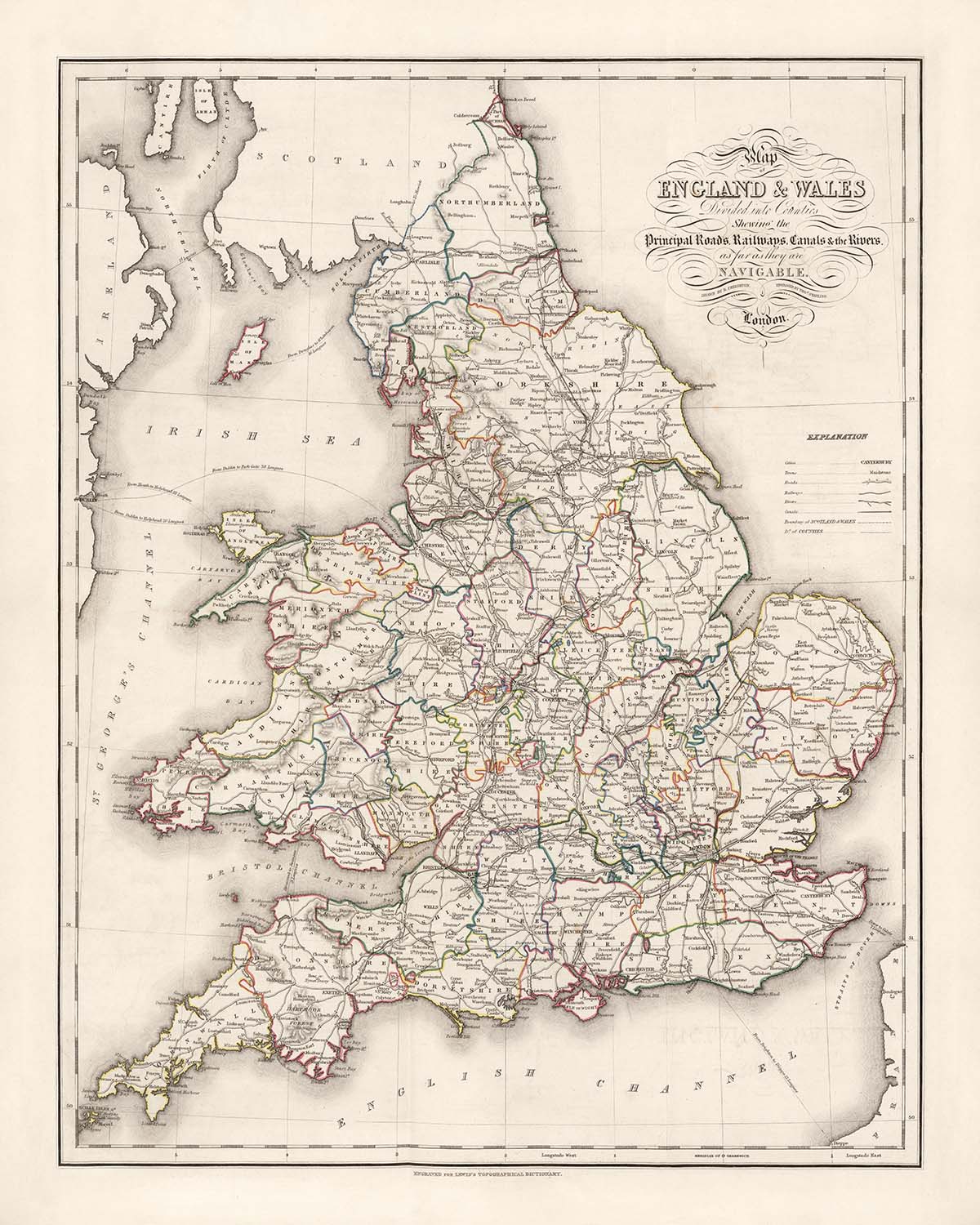
Tauchen Sie ein in die komplexe Welt der viktorianischen Kartografie mit Samuel Lewis' "Karte von England & Wales: Unterteilt in Grafschaften", einem...
WeiterlesenTauchen Sie ein in die komplexe Welt der viktorianischen Kartografie mit Samuel Lewis' "Karte von England & Wales: Unterteilt in Grafschaften", einem Meisterwerk, das 1844 erstmals veröffentlicht wurde. Diese sorgfältig handkolorierte Karte wurde erstellt, um Lewis' renommiertes Topographisches Wörterbuch zu begleiten, ein monumentales Nachschlagewerk, das die sich ständig wandelnde Landschaft des 19. Jahrhunderts in Großbritannien festhalten wollte. Der ursprüngliche Zweck der Karte war sowohl praktisch als auch wissenschaftlich: das komplizierte Flickwerk von Grafschaften, Verwaltungsgrenzen und Verkehrswegen zu beleuchten, die die Nation zu Beginn des Eisenzeitalters definierten. Ihre detaillierte Legende und präzisen Linien laden den Betrachter ein, das England und Wales einer vergangenen Ära zu erkunden, wo jede Grafschaftsgrenze und Wasserstraße mit Sorgfalt und Absicht gezeichnet wurde.
Samuel Lewis, der angesehene Verleger hinter dieser Karte, war ein visionärer Chronist der britischen Geografie. Sein Topographisches Wörterbuch und der begleitende Atlas setzten neue Maßstäbe für Genauigkeit und Vollständigkeit in einer Zeit rascher sozialer und industrieller Transformation. Die Karte selbst wurde von dem talentierten J. & C. Walker graviert und von R. Creighton gezeichnet, die beide für ihr technisches Können und ihre Kunstfertigkeit gefeiert werden. Lewis' Engagement für Klarheit und Nützlichkeit zeigt sich in jedem Aspekt der Karte, von den handkolorierten Grafschaftsgrenzen bis zur sorgfältigen Darstellung von Straßen, Eisenbahnen und Kanälen – jede eine lebenswichtige Arterie im wirtschaftlichen und kulturellen Leben des viktorianischen Großbritanniens.
Diese Karte bietet einen faszinierenden Einblick in die physische und administrative Landschaft von England und Wales während eines entscheidenden Zeitraums in der Geschichte. Die Grafschaften sind kühn umreißt, mit ihren Grenzen in lebendigen Farben hervorgehoben, während die nationale Grenze zwischen England und Wales deutlich markiert ist. Wichtige Flüsse wie die Themse, Severn, Mersey und Trent schlängeln sich über die Karte und dienen sowohl als natürliche Grenzen als auch als Lebensadern für Handel und Reisen. Die Irische See, die Nordsee und der Bristolkanal umrahmen die Landmasse, während die Küstenlinie mit exquisiten Details dargestellt ist, die jede Bucht, jeden Flussmündung und jede Halbinsel erfasst.
Die Karte ist auch eine Feier der menschlichen Besiedlung und Errungenschaften und zeigt die Standorte von Englands und Wales' berühmtesten Städten und Gemeinden. Von der pulsierenden Metropole London bis zu den industriellen Kraftzentren Birmingham, Manchester und Liverpool ist jede Siedlung sorgfältig positioniert und spiegelt ihre Bedeutung im nationalen Gefüge wider. Kleinere, aber nicht weniger bedeutende Städte – York, Oxford, Cambridge, Exeter, Cardiff, Swansea und viele mehr – sind ebenfalls verzeichnet, deren Namen Jahrhunderte von Geschichte, Kultur und lokaler Identität widerspiegeln. Die Einbeziehung von Brücken, Kanälen und frühen Eisenbahnen hebt weiter den Innovations- und Verbindungsgeist der Ära hervor.
Über die geografische Präzision hinaus steht diese Karte als Zeugnis für die Kunstfertigkeit und Ambition der britischen Kartografie des 19. Jahrhunderts. Relief wird durch zarte Hachuren dargestellt, die den Bergen und Hochländern von Wales und den Penninen Gestalt verleihen, während der Nullmeridian in Greenwich einen modernen Anker für die Navigation bietet. Als eine von 57 Karten in Lewis' gefeiertem Atlas verkörpert dieses Stück die intellektuelle Neugier und technische Meisterschaft seiner Schöpfer. Es ist nicht nur eine Karte, sondern ein lebendiges historisches Dokument – eine Einladung, durch die Landschaften, Grenzen und Geschichten zu reisen, die das viktorianische England und Wales geprägt haben.
Städte und Gemeinden auf dieser Karte
- England:
- London
- Birmingham
- Manchester
- Liverpool
- Leeds
- Sheffield
- Bristol
- Newcastle (Newcastle upon Tyne)
- Nottingham
- Leicester
- Portsmouth
- Southampton
- Plymouth
- Derby
- Stoke (Stoke-on-Trent)
- Sunderland
- Wolverhampton
- Reading
- Brighton
- Hull (Kingston upon Hull)
- Coventry
- Bradford
- Middlesbrough
- Northampton
- Luton
- Milton Keynes
- Norwich
- York
- Oxford
- Cambridge
- Exeter
- Gloucester
- Carlisle
- Chester
- Lincoln
- Bath
- Canterbury
- Hereford
- Salisbury
- Winchester
- Shrewsbury
- Worcester
- Durham
-
Wales:
- Kardiff
- Swansea
- Newport
- Wrexham
- Bangor
- St Asaph
- St Davids
- Brecon
- Carmarthen
- Haverfordwest
- Aberystwyth
Lancaster
Bemerkenswerte Merkmale & Wahrzeichen
- Die Landkreisgrenzen sind deutlich mit Handfarbe gekennzeichnet.
- Die nationale Grenze zwischen England und Wales ist markiert.
- Die Irische See, die Nordsee und der Bristolkanal sind beschriftet.
- Wichtige Flüsse wie die Themse, der Severn, der Mersey, der Trent und der Humber sind dargestellt.
- Der Nullmeridian in Greenwich ist angegeben.
- Hachuren werden verwendet, um Gebiete höherer Erhebung darzustellen, insbesondere in Regionen wie Wales und den Penninen.
- Wichtige Straßen und frühe Eisenbahnen sind markiert.
- Kanäle sind dargestellt, die ihre Bedeutung im Transport des 19. Jahrhunderts widerspiegeln.
- Wichtige Brücken sind an entscheidenden Flussübergängen markiert.
- Eine detaillierte Erklärung oder Legende ist enthalten, die die Kartensymbole und Merkmale klärt.
- Detaillierte Darstellung der Küstenlinie, einschließlich Buchten, Mündungen und Halbinseln.
Historischer und gestalterischer Kontext
- Erstellt im Jahr 1844 als Teil von Samuel Lewis' Topographischem Wörterbuch.
- Produziert von Samuel Lewis & Co., London; gestochen von J. & C. Walker und gezeichnet von R. Creighton.
- Entwickelt, um Navigationsrouten, Entfernungen und bedeutende geografische Merkmale zu veranschaulichen.
- Deckt die Länder England und Wales ab, unterteilt in Grafschaften.
- Handkoloriert und so gestaltet, dass es für die praktische Nutzung faltbar ist.
- Der Nullmeridian ist in Greenwich festgelegt, wodurch Standortreferenzen standardisiert werden.
- Spiegelt das Verständnis der Geografie, Infrastruktur und Siedlungsmuster im mittleren 19. Jahrhundert wider.
- Teil eines größeren Atlas (57 Karten), der eine umfassende Abdeckung von England und Wales während einer Zeit bedeutender sozialer und industrieller Veränderungen bietet.
Bitte überprüfen Sie die Bilder, um sicherzustellen, dass eine bestimmte Stadt oder ein bestimmter Ort auf dieser Karte angezeigt wird. Sie können sich auch mit uns in Verbindung setzen und uns bitten, die Karte für Sie zu überprüfen.
Diese Karte sieht in jeder Größe großartig aus, aber ich empfehle immer, eine größere Größe zu wählen, wenn Sie Platz haben. So können Sie alle Details leicht erkennen.
Diese Karte sieht in Größen bis zu 70 Zoll (180 cm) erstaunlich aus. Wenn Sie nach einer größeren Karte suchen, kontaktieren Sie uns bitte hier.
Das Modell in den Angebotsbildern hält die 16x20 Zoll (40x50 cm) Version dieser Karte.
Das fünfte Angebotsbild zeigt ein Beispiel für meinen Personalisierungsservice für Karten.
Wenn Sie nach etwas etwas anderem suchen, schauen Sie sich meine Sammlung der besten alten Karten an, um zu sehen, ob etwas anderes Ihr Interesse weckt.
Bitte kontaktieren Sie mich, um zu überprüfen, ob ein bestimmter Ort, Wahrzeichen oder Merkmal auf dieser Karte angezeigt wird.
Dies wäre ein wunderbares Geschenk zum Geburtstag, Weihnachten, Vatertag, Abschied von der Arbeit, Jubiläum oder Einweihung für jemanden aus den Gebieten, die von dieser Karte abgedeckt werden.
Diese Karte ist als Giclée-Druck auf säurefreiem, archivierbarem mattem Papier erhältlich, oder Sie können sie gerahmt kaufen. Der Rahmen ist ein schöner, einfacher schwarzer Rahmen, der zu den meisten Ästhetiken passt. Bitte nehmen Sie Kontakt auf, wenn Sie eine andere Rahmenfarbe oder -material wünschen. Meine Rahmen sind mit superklarem museumstauglichem Acryl (Plexiglas/Acrylt) verglast, das deutlich weniger reflektierend als Glas ist, sicherer ist und immer in perfektem Zustand ankommt.
This map is also available as a float framed canvas, sometimes known as a shadow gap framed canvas or canvas floater. The map is printed on artist's cotton canvas and then stretched over a handmade box frame. We then "float" the canvas inside a wooden frame, which is available in a range of colours (black, dark brown, oak, antique gold and white). This is a wonderful way to present a map without glazing in front. See some examples of float framed canvas maps and explore the differences between my different finishes.
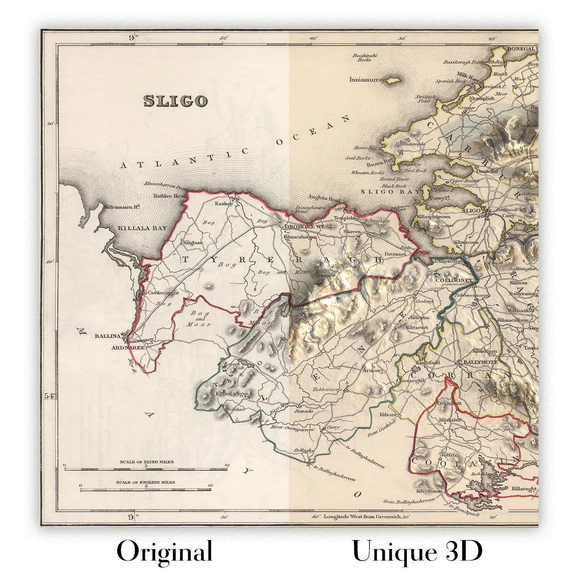
For something truly unique, this map is also available in "Unique 3D", our trademarked process that dramatically transforms the map so that it has a wonderful sense of depth. We combine the original map with detailed topography and elevation data, so that mountains and the terrain really "pop". For more info and examples of 3D maps, check my Unique 3D page.
Tauchen Sie ein in die komplexe Welt der viktorianischen Kartografie mit Samuel Lewis' "Karte von England & Wales: Unterteilt in Grafschaften", einem Meisterwerk, das 1844 erstmals veröffentlicht wurde. Diese sorgfältig handkolorierte Karte wurde erstellt, um Lewis' renommiertes Topographisches Wörterbuch zu begleiten, ein monumentales Nachschlagewerk, das die sich ständig wandelnde Landschaft des 19. Jahrhunderts in Großbritannien festhalten wollte. Der ursprüngliche Zweck der Karte war sowohl praktisch als auch wissenschaftlich: das komplizierte Flickwerk von Grafschaften, Verwaltungsgrenzen und Verkehrswegen zu beleuchten, die die Nation zu Beginn des Eisenzeitalters definierten. Ihre detaillierte Legende und präzisen Linien laden den Betrachter ein, das England und Wales einer vergangenen Ära zu erkunden, wo jede Grafschaftsgrenze und Wasserstraße mit Sorgfalt und Absicht gezeichnet wurde.
Samuel Lewis, der angesehene Verleger hinter dieser Karte, war ein visionärer Chronist der britischen Geografie. Sein Topographisches Wörterbuch und der begleitende Atlas setzten neue Maßstäbe für Genauigkeit und Vollständigkeit in einer Zeit rascher sozialer und industrieller Transformation. Die Karte selbst wurde von dem talentierten J. & C. Walker graviert und von R. Creighton gezeichnet, die beide für ihr technisches Können und ihre Kunstfertigkeit gefeiert werden. Lewis' Engagement für Klarheit und Nützlichkeit zeigt sich in jedem Aspekt der Karte, von den handkolorierten Grafschaftsgrenzen bis zur sorgfältigen Darstellung von Straßen, Eisenbahnen und Kanälen – jede eine lebenswichtige Arterie im wirtschaftlichen und kulturellen Leben des viktorianischen Großbritanniens.
Diese Karte bietet einen faszinierenden Einblick in die physische und administrative Landschaft von England und Wales während eines entscheidenden Zeitraums in der Geschichte. Die Grafschaften sind kühn umreißt, mit ihren Grenzen in lebendigen Farben hervorgehoben, während die nationale Grenze zwischen England und Wales deutlich markiert ist. Wichtige Flüsse wie die Themse, Severn, Mersey und Trent schlängeln sich über die Karte und dienen sowohl als natürliche Grenzen als auch als Lebensadern für Handel und Reisen. Die Irische See, die Nordsee und der Bristolkanal umrahmen die Landmasse, während die Küstenlinie mit exquisiten Details dargestellt ist, die jede Bucht, jeden Flussmündung und jede Halbinsel erfasst.
Die Karte ist auch eine Feier der menschlichen Besiedlung und Errungenschaften und zeigt die Standorte von Englands und Wales' berühmtesten Städten und Gemeinden. Von der pulsierenden Metropole London bis zu den industriellen Kraftzentren Birmingham, Manchester und Liverpool ist jede Siedlung sorgfältig positioniert und spiegelt ihre Bedeutung im nationalen Gefüge wider. Kleinere, aber nicht weniger bedeutende Städte – York, Oxford, Cambridge, Exeter, Cardiff, Swansea und viele mehr – sind ebenfalls verzeichnet, deren Namen Jahrhunderte von Geschichte, Kultur und lokaler Identität widerspiegeln. Die Einbeziehung von Brücken, Kanälen und frühen Eisenbahnen hebt weiter den Innovations- und Verbindungsgeist der Ära hervor.
Über die geografische Präzision hinaus steht diese Karte als Zeugnis für die Kunstfertigkeit und Ambition der britischen Kartografie des 19. Jahrhunderts. Relief wird durch zarte Hachuren dargestellt, die den Bergen und Hochländern von Wales und den Penninen Gestalt verleihen, während der Nullmeridian in Greenwich einen modernen Anker für die Navigation bietet. Als eine von 57 Karten in Lewis' gefeiertem Atlas verkörpert dieses Stück die intellektuelle Neugier und technische Meisterschaft seiner Schöpfer. Es ist nicht nur eine Karte, sondern ein lebendiges historisches Dokument – eine Einladung, durch die Landschaften, Grenzen und Geschichten zu reisen, die das viktorianische England und Wales geprägt haben.
Städte und Gemeinden auf dieser Karte
- England:
- London
- Birmingham
- Manchester
- Liverpool
- Leeds
- Sheffield
- Bristol
- Newcastle (Newcastle upon Tyne)
- Nottingham
- Leicester
- Portsmouth
- Southampton
- Plymouth
- Derby
- Stoke (Stoke-on-Trent)
- Sunderland
- Wolverhampton
- Reading
- Brighton
- Hull (Kingston upon Hull)
- Coventry
- Bradford
- Middlesbrough
- Northampton
- Luton
- Milton Keynes
- Norwich
- York
- Oxford
- Cambridge
- Exeter
- Gloucester
- Carlisle
- Chester
- Lincoln
- Bath
- Canterbury
- Hereford
- Salisbury
- Winchester
- Shrewsbury
- Worcester
- Durham
-
Wales:
- Kardiff
- Swansea
- Newport
- Wrexham
- Bangor
- St Asaph
- St Davids
- Brecon
- Carmarthen
- Haverfordwest
- Aberystwyth
Lancaster
Bemerkenswerte Merkmale & Wahrzeichen
- Die Landkreisgrenzen sind deutlich mit Handfarbe gekennzeichnet.
- Die nationale Grenze zwischen England und Wales ist markiert.
- Die Irische See, die Nordsee und der Bristolkanal sind beschriftet.
- Wichtige Flüsse wie die Themse, der Severn, der Mersey, der Trent und der Humber sind dargestellt.
- Der Nullmeridian in Greenwich ist angegeben.
- Hachuren werden verwendet, um Gebiete höherer Erhebung darzustellen, insbesondere in Regionen wie Wales und den Penninen.
- Wichtige Straßen und frühe Eisenbahnen sind markiert.
- Kanäle sind dargestellt, die ihre Bedeutung im Transport des 19. Jahrhunderts widerspiegeln.
- Wichtige Brücken sind an entscheidenden Flussübergängen markiert.
- Eine detaillierte Erklärung oder Legende ist enthalten, die die Kartensymbole und Merkmale klärt.
- Detaillierte Darstellung der Küstenlinie, einschließlich Buchten, Mündungen und Halbinseln.
Historischer und gestalterischer Kontext
- Erstellt im Jahr 1844 als Teil von Samuel Lewis' Topographischem Wörterbuch.
- Produziert von Samuel Lewis & Co., London; gestochen von J. & C. Walker und gezeichnet von R. Creighton.
- Entwickelt, um Navigationsrouten, Entfernungen und bedeutende geografische Merkmale zu veranschaulichen.
- Deckt die Länder England und Wales ab, unterteilt in Grafschaften.
- Handkoloriert und so gestaltet, dass es für die praktische Nutzung faltbar ist.
- Der Nullmeridian ist in Greenwich festgelegt, wodurch Standortreferenzen standardisiert werden.
- Spiegelt das Verständnis der Geografie, Infrastruktur und Siedlungsmuster im mittleren 19. Jahrhundert wider.
- Teil eines größeren Atlas (57 Karten), der eine umfassende Abdeckung von England und Wales während einer Zeit bedeutender sozialer und industrieller Veränderungen bietet.
Bitte überprüfen Sie die Bilder, um sicherzustellen, dass eine bestimmte Stadt oder ein bestimmter Ort auf dieser Karte angezeigt wird. Sie können sich auch mit uns in Verbindung setzen und uns bitten, die Karte für Sie zu überprüfen.
Diese Karte sieht in jeder Größe großartig aus, aber ich empfehle immer, eine größere Größe zu wählen, wenn Sie Platz haben. So können Sie alle Details leicht erkennen.
Diese Karte sieht in Größen bis zu 70 Zoll (180 cm) erstaunlich aus. Wenn Sie nach einer größeren Karte suchen, kontaktieren Sie uns bitte hier.
Das Modell in den Angebotsbildern hält die 16x20 Zoll (40x50 cm) Version dieser Karte.
Das fünfte Angebotsbild zeigt ein Beispiel für meinen Personalisierungsservice für Karten.
Wenn Sie nach etwas etwas anderem suchen, schauen Sie sich meine Sammlung der besten alten Karten an, um zu sehen, ob etwas anderes Ihr Interesse weckt.
Bitte kontaktieren Sie mich, um zu überprüfen, ob ein bestimmter Ort, Wahrzeichen oder Merkmal auf dieser Karte angezeigt wird.
Dies wäre ein wunderbares Geschenk zum Geburtstag, Weihnachten, Vatertag, Abschied von der Arbeit, Jubiläum oder Einweihung für jemanden aus den Gebieten, die von dieser Karte abgedeckt werden.
Diese Karte ist als Giclée-Druck auf säurefreiem, archivierbarem mattem Papier erhältlich, oder Sie können sie gerahmt kaufen. Der Rahmen ist ein schöner, einfacher schwarzer Rahmen, der zu den meisten Ästhetiken passt. Bitte nehmen Sie Kontakt auf, wenn Sie eine andere Rahmenfarbe oder -material wünschen. Meine Rahmen sind mit superklarem museumstauglichem Acryl (Plexiglas/Acrylt) verglast, das deutlich weniger reflektierend als Glas ist, sicherer ist und immer in perfektem Zustand ankommt.
This map is also available as a float framed canvas, sometimes known as a shadow gap framed canvas or canvas floater. The map is printed on artist's cotton canvas and then stretched over a handmade box frame. We then "float" the canvas inside a wooden frame, which is available in a range of colours (black, dark brown, oak, antique gold and white). This is a wonderful way to present a map without glazing in front. See some examples of float framed canvas maps and explore the differences between my different finishes.
For something truly unique, this map is also available in "Unique 3D", our trademarked process that dramatically transforms the map so that it has a wonderful sense of depth. We combine the original map with detailed topography and elevation data, so that mountains and the terrain really "pop". For more info and examples of 3D maps, check my Unique 3D page.
Many of our maps and art prints are chosen as thoughtful gifts for homes, offices, studies and meaningful places.
Choose a framed option for the easiest ready-to-hang gift, or choose an unframed print if the recipient may prefer to select their own frame.
We make orders locally in 23 countries around the world, so gifts can often be produced close to the recipient. This helps them arrive faster, travel more safely, and avoid customs or import duty surprises.
- We can deliver directly to the recipient
- Framed pieces arrive ready to hang
- Unframed prints are carefully packed in a strong protective tube
- Almost every order is made locally, for faster, safer gifting
- 90-day returns give the recipient time to decide
If you are not sure what to choose, please contact us. We can help you pick the right map, size, finish or delivery option.
Für die meisten Bestellungen beträgt die Lieferzeit etwa 3 Werktage. Personalisierte und maßgeschneiderte Produkte benötigen länger, da ich die Personalisierung durchführen und sie Ihnen zur Genehmigung zusenden muss, was normalerweise 1 oder 2 Tage dauert.
Bitte beachten Sie, dass sehr große gerahmte Bestellungen in der Regel länger für die Herstellung und Lieferung benötigen.
Wenn Sie möchten, dass Ihre Bestellung bis zu einem bestimmten Datum ankommt, bitte kontaktieren Sie mich, bevor Sie bestellen, damit wir den besten Weg finden können, um sicherzustellen, dass Sie Ihre Bestellung rechtzeitig erhalten.
Ich drucke und rahme Karten und Kunstwerke in 23 Ländern weltweit. Das bedeutet, dass Ihre Bestellung lokal gefertigt wird, was die Lieferzeit verkürzt und sicherstellt, dass sie während der Lieferung nicht beschädigt wird. Sie zahlen nie Zoll oder Einfuhrgebühren, und wir stoßen weniger CO2 in die Luft aus.
Alle meine Karten und Kunstdrucke sind gut verpackt und werden in einem robusten Rohr versendet, wenn sie ungerahmt sind, oder von Schaum umgeben, wenn sie gerahmt sind.
Ich versuche, alle Bestellungen innerhalb von 1 oder 2 Tagen nach Erhalt Ihrer Bestellung zu versenden, obwohl einige Produkte (wie Gesichtsmasken, Tassen und Tragetaschen) länger zur Herstellung benötigen können.
Wenn Sie Express-Lieferung an der Kasse auswählen, priorisieren wir Ihre Bestellung und versenden sie per 1-Tages-Kurier (Fedex, DHL, UPS, Parcelforce).
Nächster Tag Lieferung ist auch in einigen Ländern verfügbar (USA, UK, Singapur, VAE), aber bitte versuchen Sie, früh am Tag zu bestellen, damit wir es rechtzeitig versenden können.
Lesen Sie meinen vollständigen Leitfaden zur Lieferung und lokalen Produktion
Mein Standardrahmen ist ein Galerie-Stil-Rahmen aus schwarzem Eschenholz. Er ist einfach und sieht ziemlich modern aus. Mein Standardrahmen ist etwa 20 mm (0,8 Zoll) breit.
Ich verwende super-klares Acryl (Plexiglas/Acrylt) für das Glas des Rahmens. Es ist leichter und sicherer als Glas – und es sieht besser aus, da die Reflexion geringer ist.
Sechs Standardrahmenfarben sind kostenlos erhältlich (schwarz, dunkelbraun, dunkelgrau, Eiche, weiß und antikgold).
Die meisten Karten, Kunstwerke und Illustrationen sind auch als gerahmte Leinwand erhältlich. Wir verwenden matte (nicht glänzende) Baumwollleinwand, spannen sie über einen nachhaltig beschafften Buchenrahmen und 'schweben' dann das Stück innerhalb eines Holzrahmens. Das Endergebnis ist ziemlich schön, und es gibt keine Verglasung, die im Weg ist.
Alle Rahmen werden "bereit zum Aufhängen" geliefert, entweder mit einer Schnur oder Halterungen auf der Rückseite. Sehr große Rahmen haben schwere Aufhängeplatten und/oder eine Montageschiene. Wenn Sie Fragen haben, können Sie bitte Kontakt aufnehmen.
Sehen Sie sich einige Beispiele meiner gerahmten Karten und gerahmten Leinwandkarten an.
Alternativ kann ich auch alte Karten und Kunstwerke auf Leinwand, Schaumstoffplatten, Baumwollrag und andere Materialien liefern.
Wenn Sie Ihre Karte oder Ihr Kunstwerk selbst rahmen möchten, lesen Sie bitte zuerst meinen Größenleitfaden.
Meine Karten sind äußerst hochwertige Reproduktionen von Originalkarten.
Ich beziehe originale, seltene Karten aus Bibliotheken, Auktionshäusern und Privatsammlungen auf der ganzen Welt, restauriere sie in meiner Londoner Werkstatt und erstelle dann mit speziellen Giclée-Tinten und -Druckern wunderschöne Karten, die sogar noch besser aussehen als das Original.
Meine Karten werden auf säurefreiem, mattem Archivpapier (nicht glänzend) gedruckt, das sich sehr hochwertig anfühlt und fast wie Karton aussieht. Technisch gesehen beträgt das Papiergewicht/die Papierdicke 10mil/200g/m². Es eignet sich perfekt zum Einrahmen.
Ich drucke mit UV-lichtbeständigen Ultrachrome-Giclée-Pigmenttinten von Epson – einige der besten Tinten, die Sie finden können.
Ich kann auch machen Karten auf Leinwand, Baumwolllappen und andere exotische Materialien.
Erfahren Sie mehr über The Unique Maps Co.
Kartenpersonalisierung
Wenn Sie nach dem perfekten Geschenk zum Jahrestag oder zur Einweihung suchen, kann ich Ihre Karte personalisieren, um sie wirklich einzigartig zu machen. Ich kann beispielsweise eine kurze Nachricht hinzufügen, einen wichtigen Ort hervorheben oder das Wappen Ihrer Familie hinzufügen.
Die Möglichkeiten sind nahezu unbegrenzt. Bitte sehen Sie sich meine Kartenpersonalisierungsseite für einige wunderbare Beispiele dessen, was möglich ist.
Um eine personalisierte Karte zu bestellen, wählen Sie „Personalisieren Sie Ihre Karte“, bevor Sie sie in den Warenkorb legen.
In Kontakt kommen wenn Sie nach komplexeren Anpassungen und Personalisierungen suchen.
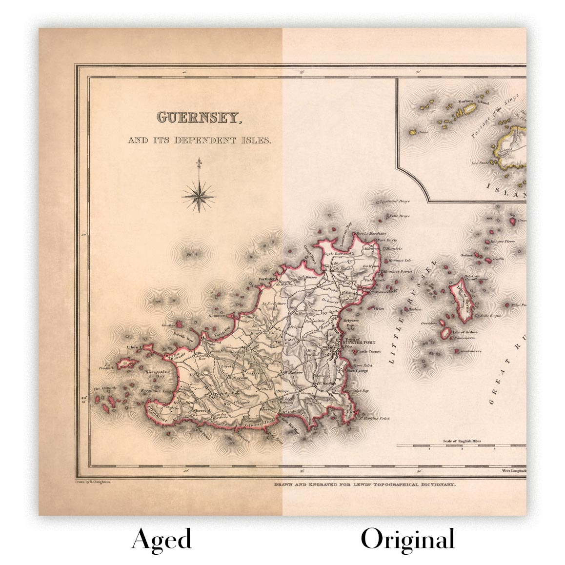
Kartenalterung
Im Laufe der Jahre wurde ich von Kunden hunderte Male gefragt, ob sie eine Karte kaufen könnten, die noch älter.
Nun, jetzt können Sie das, indem Sie „Alter“ auswählen, bevor Sie eine Karte in Ihren Warenkorb legen.
Alle Produktfotos, die Sie auf dieser Seite sehen, zeigen die Karte in ihrer Originalform. So sieht die Karte heute aus.
Wenn Sie „Gealtert“ auswählen, werde ich Ihre Karte von Hand altern lassen. Dazu verwende ich ein spezielles und einzigartiges Verfahren, das ich durch jahrelanges Studium alter Karten und Gespräche mit Forschern zum Verständnis der Chemie alternder Papiere entwickelt habe, und natürlich ... viel Übung!
Wenn Sie sich nicht sicher sind, bleiben Sie bei der Originalfarbe der Karte. Wenn Sie etwas Dunkleres und älter Wenn Sie auf der Suche sind, entscheiden Sie sich für „Aged“.
Sehen Sie einige erstaunliche Beispiele für gealterte Karten.
Wenn Sie aus irgendeinem Grund mit Ihrer Bestellung nicht zufrieden sind, kontaktieren Sie mich für eine unkomplizierte Rückerstattung. Bitte sehen Sie sich unsere Rückgabe- und Rückerstattungsrichtlinien für weitere Informationen an.
Ich bin sehr zuversichtlich, dass Ihnen Ihre restaurierte Karte oder Kunstdruck gefallen wird. Ich mache das seit 1984. Ich bin ein 5-Sterne Etsy-Verkäufer. Ich habe Zehntausende von Karten und Kunstdrucken verkauft und habe über 5.000 echte 5-Sterne-Bewertungen.
Ich verwende einen einzigartigen Prozess, um Karten und Kunstwerke zu restaurieren, der extrem zeitaufwendig und arbeitsintensiv ist. Die Suche nach den Originalkarten und Illustrationen kann Monate dauern. Ich benutze modernste und unglaublich teure Technologie, um sie zu scannen und wiederherzustellen. Daher garantiere ich, dass meine Karten und Kunstdrucke eine Klasse für sich sind - deshalb kann ich eine unkomplizierte Rückerstattung anbieten.
Fast alle meine Karten und Kunstdrucke sehen in großen Größen (200 cm, 6,5 Fuß+) erstaunlich aus und ich kann sie Ihnen auch gerahmt und über einen speziellen Übergrößen-Kurier liefern. Kontaktieren Sie mich, um Ihre speziellen Bedürfnisse zu besprechen.
Or try searching for something!


