


Große alte Karte von Oxford von Hoggar, 1850: Colleges, St. Giles', High St, Magdalen St, Fluss Thames
20% Rabatt auf 2 — 33% Rabatt auf 3
Fügen Sie beliebige zwei berechtigte Artikel zu Ihrem Warenkorb hinzu, um 20% Rabatt zu erhalten. Fügen Sie einen dritten hinzu und er ist kostenlos (entspricht 33% Rabatt, wenn Sie drei kaufen).
Kein Code erforderlich — das Angebot wird automatisch an der Kasse angewendet.
Gültig für alle Standardkarten und Kunstdrucke. Sie können beliebige Designs kombinieren.
Wenn Sie Artikel an mehrere Adressen versenden möchten, kontaktieren Sie uns bitte, bevor Sie Ihre Bestellung aufgeben.
Maßanfertigungen und individuelle Aufträge sind ausgeschlossen.
Kontaktieren Sie uns wenn Sie Fragen haben
 In London gestaltet Hergestellt in the UK
In London gestaltet • Hergestellt in the UK
In London gestaltet Hergestellt in the UK
In London gestaltet • Hergestellt in the UK

Aus der Originalkarte von 1850 restauriert und in Museumsqualität gedruckt. Die Geschichte hinter dieser Karte lesen
Choose your size
Choose your finish


(Mehr Infos)
Geschenkmitteilung & individuelle Ausführung

Wenn Sie eine Geschenkmitteilung oder eine Ausführung (Puzzle, Aluminiumplatte usw.) hinzufügen möchten, die hier nicht verfügbar ist, geben Sie dies bitte in der "Bestellnotiz" beim Checkout an.
Jede Bestellung wird individuell angefertigt. Wenn Sie die Größe leicht anpassen oder auf einem ungewöhnlichen Material drucken lassen möchten, lassen Sie es uns einfach wissen. Wir haben im Laufe der Jahre Tausende von individuellen Bestellungen bearbeitet, daher gibt es (fast) nichts, was wir nicht bewältigen können.
Sie können uns auch kontaktieren, bevor Sie bestellen, wenn Sie möchten!

- Lokal gefertigt. Sicher geliefert
- Keine Zölle oder versteckten Gebühren
- Hilfe nötig? Rufen Sie uns an oder WhatsApp schreiben
Own a piece of history
8,000+ five-star reviews


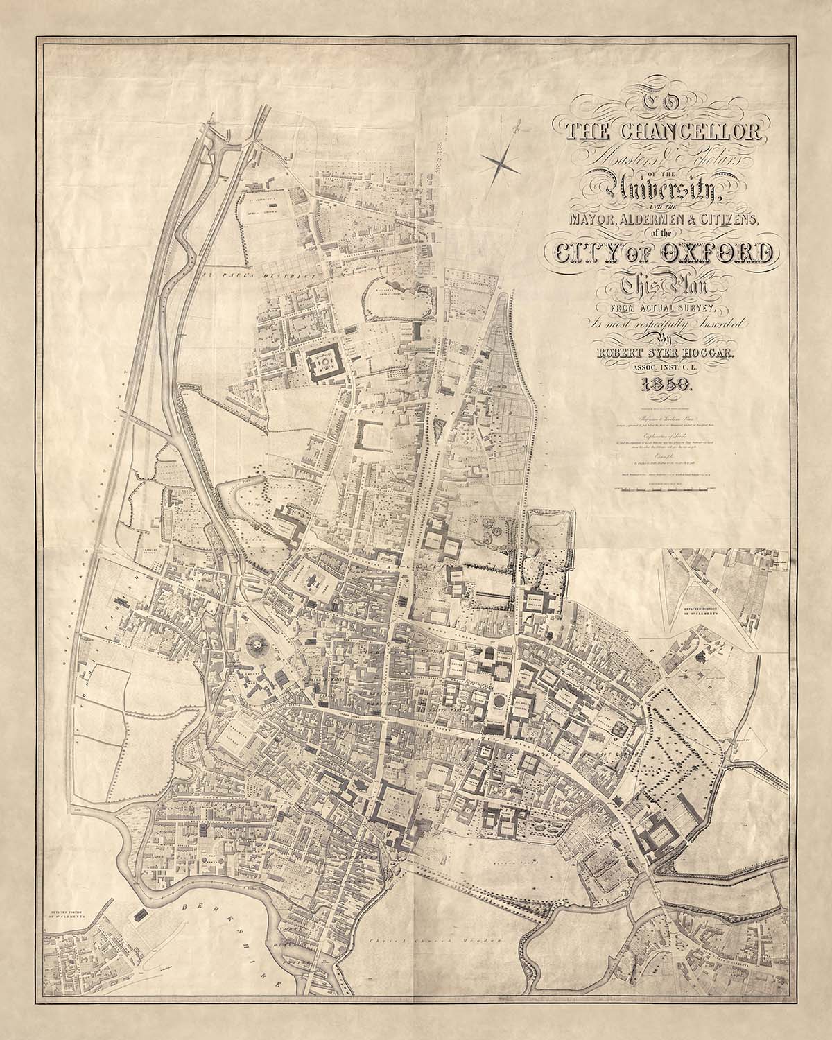
Der "Stadtplan von Oxford" von Robert Syer Hoggar, erstellt im Jahr 1850, ist ein faszinierender Einblick in das historische Herz einer der...
WeiterlesenDer "Stadtplan von Oxford" von Robert Syer Hoggar, erstellt im Jahr 1850, ist ein faszinierender Einblick in das historische Herz einer der bekanntesten Städte Englands. Diese Karte, die für die sanitäre Untersuchung der Oxford Paving Commissioners von 1851 erstellt wurde, ist nicht nur ein Navigationswerkzeug, sondern ein detailliertes Porträt des städtischen Lebens im mittleren 19. Jahrhundert. Mit ihrer sorgfältigen Darstellung der wichtigsten Gebäude, Colleges und klar markierten Kreis- und Pfarreigrenzen bietet sie ein Fenster in die architektonische und bürgerliche Landschaft jener Zeit. Die Präzision und Eleganz der Karte spiegeln Hoggars Fachkenntnis als Mitglied der Institution of Civil Engineers wider.
Die Arbeit von Robert Syer Hoggar ist ein Zeugnis für die Kunst und Wissenschaft der Kartographie im 19. Jahrhundert. Seine Verbindung zur Institution of Civil Engineers unterstreicht sein Engagement für Genauigkeit und Detail, was diese Karte zu einer wertvollen Ressource für Historiker und Enthusiasten gleichermaßen macht. Graviert von Thos. Jones, ist die Karte ein Meisterwerk des Designs, das die komplexen Straßenmuster und bedeutenden Wahrzeichen zeigt, die Oxford prägen. Hoggars Hingabe an sein Handwerk ist in jeder Linie und Kontur sichtbar und fängt das Wesen einer Stadt ein, die reich an Geschichte und Tradition ist.
Oxford, mit seinem reichen Geflecht aus Stadtvierteln und Wahrzeichen, wird durch Hoggars Karte lebendig. Die Darstellung von Gebieten wie St. Giles' und Cornmarket Street offenbart das lebendige urbane Gewebe der Stadt. Jede Straße und jedes Gebäude ist sorgfältig dargestellt und bietet Einblicke in das tägliche Leben und die soziale Struktur der damaligen Zeit. Die Einbeziehung bedeutender Hauptstraßen wie der High Street und der Magdalen Street hebt die geschäftigen kommerziellen und akademischen Aktivitäten hervor, die lange das Markenzeichen der Stadt sind.
Die Karte bietet auch einen faszinierenden Blick auf Oxfords natürliche und gebaute Umgebung. Die Präsenz der Themse, die sich durch die Stadt schlängelt, fügt der urbanen Landschaft ein dynamisches Element hinzu. Die sorgfältige Markierung von Parks und Freiflächen spiegelt das Engagement der Stadt für grüne Bereiche inmitten ihrer architektonischen Pracht wider. Dieses Gleichgewicht zwischen Natur und Urbanität ist ein prägendes Merkmal Oxfords, und Hoggars Karte fängt es mit bemerkenswerter Klarheit und Schönheit ein.
Zusammengefasst ist der "Stadtplan von Oxford" mehr als nur eine Karte; es ist ein historisches Dokument, das den Geist einer Stadt in einem entscheidenden Moment ihrer Entwicklung einfängt. Seine detaillierte Darstellung von Oxfords Straßen, Gebäuden und Grenzen bietet eine einzigartige Perspektive auf die Entwicklung der Stadt und ihr bleibendes Erbe. Für Sammler und Historiker ist diese Karte eine Schatztruhe voller Informationen und ein Zeugnis für die Kunstfertigkeit und Präzision der Kartographie des 19. Jahrhunderts.
Straßen und Wege auf dieser Karte
- Banbury Road
- Beaumont Street
- Broad Street
- Cornmarket Street
- George Street
- High Street
- Holywell Street
- Longwall Street
- Magdalen Street
- New Inn Hall Street
- New Road
- Parks Road
- Queen Street
- St. Aldate's
- St. Clement's Street
- St. Giles'
- St. John Street
- Turl Street
- Walton Street
- Wellington Square
- Worcester Street
Bemerkenswerte Merkmale & Wahrzeichen
- Einlegekarten:
- Zwei Einlegekarten von abgetrennten Teilen der Pfarrei St. Clement's.
- Wahrzeichen:
- Zahlreiche Hauptgebäude sind benannt.
- Stadtviertel:
- Detailierte Anordnung der Stadtstraßen und Stadtviertel innerhalb von Oxford.
- Hochschulen:
- Alle bestehenden Oxford-Hochschulen aus dem Jahr 1850 sind auf dieser Karte deutlich dargestellt
Historischer und gestalterischer Kontext
- Erstellungsdatum: 1850
- Kartenmacher/Verleger: Robert Syer Hoggar, gestochen von Thos. Jones
- Zweck: Produziert für die sanitäre Untersuchung der Oxford Paving Commissioners von 1851.
- Themen und Themenbereiche:
- Illustriert die wichtigsten Gebäude und markiert die Grenzen von Grafschaften und Pfarreien.
- Maßstab: 1 Zoll zu 44 Fuß (1:1584).
- Gezeigte Regionen: Die Stadt Oxford, England.
- Design/Stil: Detaillierte Straßenkarte mit Schwerpunkt auf Gebäuden und Grenzen, typisch für die Stadtplanung und Vermessungskarten des mittleren 19. Jahrhunderts.
- Historische Bedeutung: Spiegelt die Stadtplanung und sanitären Bedenken der damaligen Zeit wider und bietet Einblicke in das Oxford des mittleren 19. Jahrhunderts.
Bitte überprüfen Sie die Bilder, um sicherzustellen, dass eine bestimmte Stadt oder ein bestimmter Ort auf dieser Karte dargestellt ist. Sie können auch Kontakt aufnehmen und uns bitten, die Karte für Sie zu überprüfen.
Dies ist eine sehr große Karte, die in großer Größe bestellt werden muss, damit Sie alle Details leicht erkennen können.
Diese Karte sieht in Größen bis zu 100 Zoll (250 cm) fantastisch aus. Wenn Sie eine größere Karte suchen, bitte nehmen Sie Kontakt auf.
Das Modell in den Abbildungsbildern hält die 16x20 Zoll (40x50 cm) Version dieser Karte.
Das fünfte Abbildungsbild zeigt ein Beispiel für meinen Personalisierungsservice für Karten.
Wenn Sie nach etwas leicht anderem suchen, schauen Sie sich meine Sammlung der besten alten Karten an, um zu sehen, ob Ihnen etwas anderes ins Auge fällt.
Bitte kontaktieren Sie mich, um zu überprüfen, ob ein bestimmter Standort, Wahrzeichen oder Merkmal auf dieser Karte dargestellt ist.
Dies wäre ein wunderbares Geschenk zum Geburtstag, Weihnachten, Vatertag, Abschied von der Arbeit, Jubiläum oder Einweihung für jemanden aus den von dieser Karte abgedeckten Bereichen.
Diese Karte ist als Giclée-Druck auf säurefreiem, archivierbarem, mattem Papier erhältlich, oder Sie können sie gerahmt kaufen. Der Rahmen ist ein schöner, einfacher schwarzer Rahmen, der zu den meisten Ästhetiken passt. Bitte nehmen Sie Kontakt auf, wenn Sie eine andere Rahmenfarbe oder -material wünschen. Meine Rahmen sind mit superklarem, museumsglanzendem Acryl (Plexiglas/Acrylt) verglast, das deutlich weniger reflektierend als Glas ist, sicherer und immer in perfektem Zustand ankommt.
This map is also available as a float framed canvas, sometimes known as a shadow gap framed canvas or canvas floater. The map is printed on artist's cotton canvas and then stretched over a handmade box frame. We then "float" the canvas inside a wooden frame, which is available in a range of colours (black, dark brown, oak, antique gold and white). This is a wonderful way to present a map without glazing in front. See some examples of float framed canvas maps and explore the differences between my different finishes.
For something truly unique, this map is also available in "Unique 3D", our trademarked process that dramatically transforms the map so that it has a wonderful sense of depth. We combine the original map with detailed topography and elevation data, so that mountains and the terrain really "pop". For more info and examples of 3D maps, check my Unique 3D page.
Der "Stadtplan von Oxford" von Robert Syer Hoggar, erstellt im Jahr 1850, ist ein faszinierender Einblick in das historische Herz einer der bekanntesten Städte Englands. Diese Karte, die für die sanitäre Untersuchung der Oxford Paving Commissioners von 1851 erstellt wurde, ist nicht nur ein Navigationswerkzeug, sondern ein detailliertes Porträt des städtischen Lebens im mittleren 19. Jahrhundert. Mit ihrer sorgfältigen Darstellung der wichtigsten Gebäude, Colleges und klar markierten Kreis- und Pfarreigrenzen bietet sie ein Fenster in die architektonische und bürgerliche Landschaft jener Zeit. Die Präzision und Eleganz der Karte spiegeln Hoggars Fachkenntnis als Mitglied der Institution of Civil Engineers wider.
Die Arbeit von Robert Syer Hoggar ist ein Zeugnis für die Kunst und Wissenschaft der Kartographie im 19. Jahrhundert. Seine Verbindung zur Institution of Civil Engineers unterstreicht sein Engagement für Genauigkeit und Detail, was diese Karte zu einer wertvollen Ressource für Historiker und Enthusiasten gleichermaßen macht. Graviert von Thos. Jones, ist die Karte ein Meisterwerk des Designs, das die komplexen Straßenmuster und bedeutenden Wahrzeichen zeigt, die Oxford prägen. Hoggars Hingabe an sein Handwerk ist in jeder Linie und Kontur sichtbar und fängt das Wesen einer Stadt ein, die reich an Geschichte und Tradition ist.
Oxford, mit seinem reichen Geflecht aus Stadtvierteln und Wahrzeichen, wird durch Hoggars Karte lebendig. Die Darstellung von Gebieten wie St. Giles' und Cornmarket Street offenbart das lebendige urbane Gewebe der Stadt. Jede Straße und jedes Gebäude ist sorgfältig dargestellt und bietet Einblicke in das tägliche Leben und die soziale Struktur der damaligen Zeit. Die Einbeziehung bedeutender Hauptstraßen wie der High Street und der Magdalen Street hebt die geschäftigen kommerziellen und akademischen Aktivitäten hervor, die lange das Markenzeichen der Stadt sind.
Die Karte bietet auch einen faszinierenden Blick auf Oxfords natürliche und gebaute Umgebung. Die Präsenz der Themse, die sich durch die Stadt schlängelt, fügt der urbanen Landschaft ein dynamisches Element hinzu. Die sorgfältige Markierung von Parks und Freiflächen spiegelt das Engagement der Stadt für grüne Bereiche inmitten ihrer architektonischen Pracht wider. Dieses Gleichgewicht zwischen Natur und Urbanität ist ein prägendes Merkmal Oxfords, und Hoggars Karte fängt es mit bemerkenswerter Klarheit und Schönheit ein.
Zusammengefasst ist der "Stadtplan von Oxford" mehr als nur eine Karte; es ist ein historisches Dokument, das den Geist einer Stadt in einem entscheidenden Moment ihrer Entwicklung einfängt. Seine detaillierte Darstellung von Oxfords Straßen, Gebäuden und Grenzen bietet eine einzigartige Perspektive auf die Entwicklung der Stadt und ihr bleibendes Erbe. Für Sammler und Historiker ist diese Karte eine Schatztruhe voller Informationen und ein Zeugnis für die Kunstfertigkeit und Präzision der Kartographie des 19. Jahrhunderts.
Straßen und Wege auf dieser Karte
- Banbury Road
- Beaumont Street
- Broad Street
- Cornmarket Street
- George Street
- High Street
- Holywell Street
- Longwall Street
- Magdalen Street
- New Inn Hall Street
- New Road
- Parks Road
- Queen Street
- St. Aldate's
- St. Clement's Street
- St. Giles'
- St. John Street
- Turl Street
- Walton Street
- Wellington Square
- Worcester Street
Bemerkenswerte Merkmale & Wahrzeichen
- Einlegekarten:
- Zwei Einlegekarten von abgetrennten Teilen der Pfarrei St. Clement's.
- Wahrzeichen:
- Zahlreiche Hauptgebäude sind benannt.
- Stadtviertel:
- Detailierte Anordnung der Stadtstraßen und Stadtviertel innerhalb von Oxford.
- Hochschulen:
- Alle bestehenden Oxford-Hochschulen aus dem Jahr 1850 sind auf dieser Karte deutlich dargestellt
Historischer und gestalterischer Kontext
- Erstellungsdatum: 1850
- Kartenmacher/Verleger: Robert Syer Hoggar, gestochen von Thos. Jones
- Zweck: Produziert für die sanitäre Untersuchung der Oxford Paving Commissioners von 1851.
- Themen und Themenbereiche:
- Illustriert die wichtigsten Gebäude und markiert die Grenzen von Grafschaften und Pfarreien.
- Maßstab: 1 Zoll zu 44 Fuß (1:1584).
- Gezeigte Regionen: Die Stadt Oxford, England.
- Design/Stil: Detaillierte Straßenkarte mit Schwerpunkt auf Gebäuden und Grenzen, typisch für die Stadtplanung und Vermessungskarten des mittleren 19. Jahrhunderts.
- Historische Bedeutung: Spiegelt die Stadtplanung und sanitären Bedenken der damaligen Zeit wider und bietet Einblicke in das Oxford des mittleren 19. Jahrhunderts.
Bitte überprüfen Sie die Bilder, um sicherzustellen, dass eine bestimmte Stadt oder ein bestimmter Ort auf dieser Karte dargestellt ist. Sie können auch Kontakt aufnehmen und uns bitten, die Karte für Sie zu überprüfen.
Dies ist eine sehr große Karte, die in großer Größe bestellt werden muss, damit Sie alle Details leicht erkennen können.
Diese Karte sieht in Größen bis zu 100 Zoll (250 cm) fantastisch aus. Wenn Sie eine größere Karte suchen, bitte nehmen Sie Kontakt auf.
Das Modell in den Abbildungsbildern hält die 16x20 Zoll (40x50 cm) Version dieser Karte.
Das fünfte Abbildungsbild zeigt ein Beispiel für meinen Personalisierungsservice für Karten.
Wenn Sie nach etwas leicht anderem suchen, schauen Sie sich meine Sammlung der besten alten Karten an, um zu sehen, ob Ihnen etwas anderes ins Auge fällt.
Bitte kontaktieren Sie mich, um zu überprüfen, ob ein bestimmter Standort, Wahrzeichen oder Merkmal auf dieser Karte dargestellt ist.
Dies wäre ein wunderbares Geschenk zum Geburtstag, Weihnachten, Vatertag, Abschied von der Arbeit, Jubiläum oder Einweihung für jemanden aus den von dieser Karte abgedeckten Bereichen.
Diese Karte ist als Giclée-Druck auf säurefreiem, archivierbarem, mattem Papier erhältlich, oder Sie können sie gerahmt kaufen. Der Rahmen ist ein schöner, einfacher schwarzer Rahmen, der zu den meisten Ästhetiken passt. Bitte nehmen Sie Kontakt auf, wenn Sie eine andere Rahmenfarbe oder -material wünschen. Meine Rahmen sind mit superklarem, museumsglanzendem Acryl (Plexiglas/Acrylt) verglast, das deutlich weniger reflektierend als Glas ist, sicherer und immer in perfektem Zustand ankommt.
This map is also available as a float framed canvas, sometimes known as a shadow gap framed canvas or canvas floater. The map is printed on artist's cotton canvas and then stretched over a handmade box frame. We then "float" the canvas inside a wooden frame, which is available in a range of colours (black, dark brown, oak, antique gold and white). This is a wonderful way to present a map without glazing in front. See some examples of float framed canvas maps and explore the differences between my different finishes.
For something truly unique, this map is also available in "Unique 3D", our trademarked process that dramatically transforms the map so that it has a wonderful sense of depth. We combine the original map with detailed topography and elevation data, so that mountains and the terrain really "pop". For more info and examples of 3D maps, check my Unique 3D page.
Many of our maps and art prints are chosen as thoughtful gifts for homes, offices, studies and meaningful places.
Choose a framed option for the easiest ready-to-hang gift, or choose an unframed print if the recipient may prefer to select their own frame.
We make orders locally in 23 countries around the world, so gifts can often be produced close to the recipient. This helps them arrive faster, travel more safely, and avoid customs or import duty surprises.
- We can deliver directly to the recipient
- Framed pieces arrive ready to hang
- Unframed prints are carefully packed in a strong protective tube
- Almost every order is made locally, for faster, safer gifting
- 90-day returns give the recipient time to decide
If you are not sure what to choose, please contact us. We can help you pick the right map, size, finish or delivery option.
Für die meisten Bestellungen beträgt die Lieferzeit etwa 3 Werktage. Personalisierte und maßgeschneiderte Produkte benötigen länger, da ich die Personalisierung durchführen und sie Ihnen zur Genehmigung zusenden muss, was normalerweise 1 oder 2 Tage dauert.
Bitte beachten Sie, dass sehr große gerahmte Bestellungen in der Regel länger für die Herstellung und Lieferung benötigen.
Wenn Sie möchten, dass Ihre Bestellung bis zu einem bestimmten Datum ankommt, bitte kontaktieren Sie mich, bevor Sie bestellen, damit wir den besten Weg finden können, um sicherzustellen, dass Sie Ihre Bestellung rechtzeitig erhalten.
Ich drucke und rahme Karten und Kunstwerke in 23 Ländern weltweit. Das bedeutet, dass Ihre Bestellung lokal gefertigt wird, was die Lieferzeit verkürzt und sicherstellt, dass sie während der Lieferung nicht beschädigt wird. Sie zahlen nie Zoll oder Einfuhrgebühren, und wir stoßen weniger CO2 in die Luft aus.
Alle meine Karten und Kunstdrucke sind gut verpackt und werden in einem robusten Rohr versendet, wenn sie ungerahmt sind, oder von Schaum umgeben, wenn sie gerahmt sind.
Ich versuche, alle Bestellungen innerhalb von 1 oder 2 Tagen nach Erhalt Ihrer Bestellung zu versenden, obwohl einige Produkte (wie Gesichtsmasken, Tassen und Tragetaschen) länger zur Herstellung benötigen können.
Wenn Sie Express-Lieferung an der Kasse auswählen, priorisieren wir Ihre Bestellung und versenden sie per 1-Tages-Kurier (Fedex, DHL, UPS, Parcelforce).
Nächster Tag Lieferung ist auch in einigen Ländern verfügbar (USA, UK, Singapur, VAE), aber bitte versuchen Sie, früh am Tag zu bestellen, damit wir es rechtzeitig versenden können.
Lesen Sie meinen vollständigen Leitfaden zur Lieferung und lokalen Produktion
Mein Standardrahmen ist ein Galerie-Stil-Rahmen aus schwarzem Eschenholz. Er ist einfach und sieht ziemlich modern aus. Mein Standardrahmen ist etwa 20 mm (0,8 Zoll) breit.
Ich verwende super-klares Acryl (Plexiglas/Acrylt) für das Glas des Rahmens. Es ist leichter und sicherer als Glas – und es sieht besser aus, da die Reflexion geringer ist.
Sechs Standardrahmenfarben sind kostenlos erhältlich (schwarz, dunkelbraun, dunkelgrau, Eiche, weiß und antikgold).
Die meisten Karten, Kunstwerke und Illustrationen sind auch als gerahmte Leinwand erhältlich. Wir verwenden matte (nicht glänzende) Baumwollleinwand, spannen sie über einen nachhaltig beschafften Buchenrahmen und 'schweben' dann das Stück innerhalb eines Holzrahmens. Das Endergebnis ist ziemlich schön, und es gibt keine Verglasung, die im Weg ist.
Alle Rahmen werden "bereit zum Aufhängen" geliefert, entweder mit einer Schnur oder Halterungen auf der Rückseite. Sehr große Rahmen haben schwere Aufhängeplatten und/oder eine Montageschiene. Wenn Sie Fragen haben, können Sie bitte Kontakt aufnehmen.
Sehen Sie sich einige Beispiele meiner gerahmten Karten und gerahmten Leinwandkarten an.
Alternativ kann ich auch alte Karten und Kunstwerke auf Leinwand, Schaumstoffplatten, Baumwollrag und andere Materialien liefern.
Wenn Sie Ihre Karte oder Ihr Kunstwerk selbst rahmen möchten, lesen Sie bitte zuerst meinen Größenleitfaden.
Meine Karten sind äußerst hochwertige Reproduktionen von Originalkarten.
Ich beziehe originale, seltene Karten aus Bibliotheken, Auktionshäusern und Privatsammlungen auf der ganzen Welt, restauriere sie in meiner Londoner Werkstatt und erstelle dann mit speziellen Giclée-Tinten und -Druckern wunderschöne Karten, die sogar noch besser aussehen als das Original.
Meine Karten werden auf säurefreiem, mattem Archivpapier (nicht glänzend) gedruckt, das sich sehr hochwertig anfühlt und fast wie Karton aussieht. Technisch gesehen beträgt das Papiergewicht/die Papierdicke 10mil/200g/m². Es eignet sich perfekt zum Einrahmen.
Ich drucke mit UV-lichtbeständigen Ultrachrome-Giclée-Pigmenttinten von Epson – einige der besten Tinten, die Sie finden können.
Ich kann auch machen Karten auf Leinwand, Baumwolllappen und andere exotische Materialien.
Erfahren Sie mehr über The Unique Maps Co.
Kartenpersonalisierung
Wenn Sie nach dem perfekten Geschenk zum Jahrestag oder zur Einweihung suchen, kann ich Ihre Karte personalisieren, um sie wirklich einzigartig zu machen. Ich kann beispielsweise eine kurze Nachricht hinzufügen, einen wichtigen Ort hervorheben oder das Wappen Ihrer Familie hinzufügen.
Die Möglichkeiten sind nahezu unbegrenzt. Bitte sehen Sie sich meine Kartenpersonalisierungsseite für einige wunderbare Beispiele dessen, was möglich ist.
Um eine personalisierte Karte zu bestellen, wählen Sie „Personalisieren Sie Ihre Karte“, bevor Sie sie in den Warenkorb legen.
In Kontakt kommen wenn Sie nach komplexeren Anpassungen und Personalisierungen suchen.
Kartenalterung
Im Laufe der Jahre wurde ich von Kunden hunderte Male gefragt, ob sie eine Karte kaufen könnten, die noch älter.
Nun, jetzt können Sie das, indem Sie „Alter“ auswählen, bevor Sie eine Karte in Ihren Warenkorb legen.
Alle Produktfotos, die Sie auf dieser Seite sehen, zeigen die Karte in ihrer Originalform. So sieht die Karte heute aus.
Wenn Sie „Gealtert“ auswählen, werde ich Ihre Karte von Hand altern lassen. Dazu verwende ich ein spezielles und einzigartiges Verfahren, das ich durch jahrelanges Studium alter Karten und Gespräche mit Forschern zum Verständnis der Chemie alternder Papiere entwickelt habe, und natürlich ... viel Übung!
Wenn Sie sich nicht sicher sind, bleiben Sie bei der Originalfarbe der Karte. Wenn Sie etwas Dunkleres und älter Wenn Sie auf der Suche sind, entscheiden Sie sich für „Aged“.
Sehen Sie einige erstaunliche Beispiele für gealterte Karten.
Wenn Sie aus irgendeinem Grund mit Ihrer Bestellung nicht zufrieden sind, kontaktieren Sie mich für eine unkomplizierte Rückerstattung. Bitte sehen Sie sich unsere Rückgabe- und Rückerstattungsrichtlinien für weitere Informationen an.
Ich bin sehr zuversichtlich, dass Ihnen Ihre restaurierte Karte oder Kunstdruck gefallen wird. Ich mache das seit 1984. Ich bin ein 5-Sterne Etsy-Verkäufer. Ich habe Zehntausende von Karten und Kunstdrucken verkauft und habe über 5.000 echte 5-Sterne-Bewertungen.
Ich verwende einen einzigartigen Prozess, um Karten und Kunstwerke zu restaurieren, der extrem zeitaufwendig und arbeitsintensiv ist. Die Suche nach den Originalkarten und Illustrationen kann Monate dauern. Ich benutze modernste und unglaublich teure Technologie, um sie zu scannen und wiederherzustellen. Daher garantiere ich, dass meine Karten und Kunstdrucke eine Klasse für sich sind - deshalb kann ich eine unkomplizierte Rückerstattung anbieten.
Fast alle meine Karten und Kunstdrucke sehen in großen Größen (200 cm, 6,5 Fuß+) erstaunlich aus und ich kann sie Ihnen auch gerahmt und über einen speziellen Übergrößen-Kurier liefern. Kontaktieren Sie mich, um Ihre speziellen Bedürfnisse zu besprechen.
Or try searching for something!


