


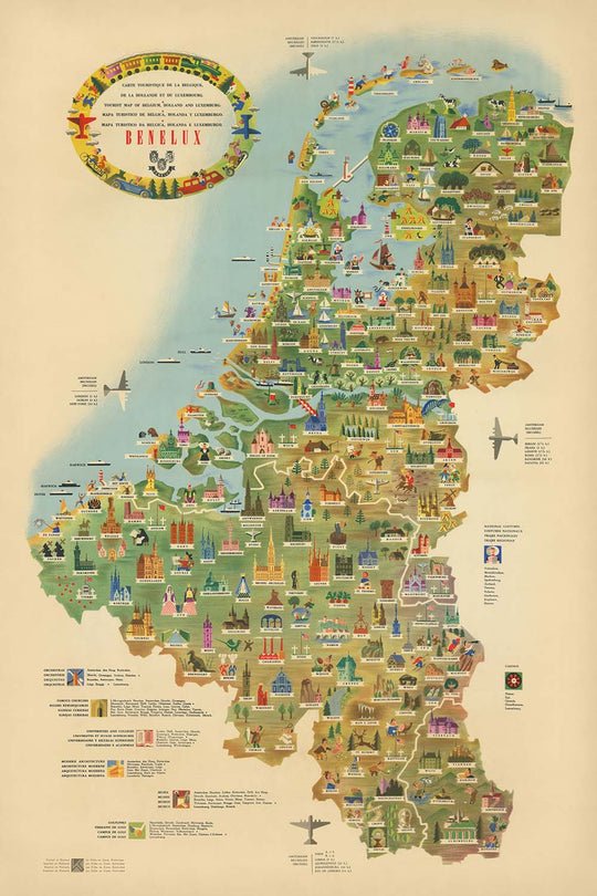


Alte bildliche Touristenkarte von Benelux, 1950: Optimismus nach dem Zweiten Weltkrieg, Brüssel, Amsterdam, Rhein, Windmühlen

-
![]() Handmade in the UK (we're based in London)
Handmade in the UK (we're based in London)
-
FREE worldwide delivery in 2-3 days ⓘ
Free delivery in 2-3 days
Your map should be delivered in 2-3 working days with free delivery, worldwide.
We make maps by hand locally in 23 countries. If you're buying a gift for someone in another country, we will make the map locally to them.
You will never pay import tax or customs duty.
Express delivery is available at checkout which can reduce the delivery time to 1-2 days.
Please note that personalised maps, and larger framed maps, can take longer to produce and deliver.
If you need your order to arrive by a certain date, contact me and we can discuss your options.
-
90 day money back guarantee
ⓘ
90 Tage für Rückgabe und Rückerstattung
Produkte können innerhalb von 90 Tagen für eine vollständige Rückerstattung oder einen Umtausch gegen ein anderes Produkt zurückgegeben werden.
Für personalisierte oder maßgefertigte Artikel können wir Ihnen möglicherweise Guthaben im Geschäft oder eine nicht ablaufende Geschenkkarte anbieten, da wir personalisierte Bestellungen nicht wiederverkaufen können.
Wenn Sie Fragen haben, nehmen Sie Kontakt auf. Für weitere Informationen siehe unsere vollständige Rückgabe- und Umtauschrichtlinie.

My maps are rare, museum-grade, restored old maps sourced from libraries, auction houses and private collections across the globe.
Framing & free personalisation available
1. Select your size
2. Frame & personalise your map
Make your map unique with framing, hand-drawn customisation, vintage ageing, pop art text, unique 3D styling and moreGeschenkmitteilung & individuelle Ausführung

Wenn Sie eine Geschenkmitteilung oder eine Ausführung (Puzzle, Aluminiumplatte usw.) hinzufügen möchten, die hier nicht verfügbar ist, geben Sie dies bitte in der "Bestellnotiz" beim Checkout an.
Jede Bestellung wird individuell angefertigt. Wenn Sie die Größe leicht anpassen oder auf einem ungewöhnlichen Material drucken lassen möchten, lassen Sie es uns einfach wissen. Wir haben im Laufe der Jahre Tausende von individuellen Bestellungen bearbeitet, daher gibt es (fast) nichts, was wir nicht bewältigen können.
Sie können uns auch kontaktieren, bevor Sie bestellen, wenn Sie möchten!

- Handmade locally. No import duty or tax
- FREE Delivery. Arrives in 2-3 days
- Love it or your money back
- Questions? WhatsApp me any time
Own a piece of history
5,000+ 5 star reviews


Betreten Sie die lebendige Welt des Nachkriegs-Europas mit der „Carte Touristique de la Belgique, de la Hollande et du Luxembourg“, einer fesselnden bildlichen Karte, die 1950 von den renommierten Libra Studios in Zusammenarbeit mit Kühn & Zoon geschaffen wurde. Dieses exquisite Stück ist eine visuelle Feier der Benelux-Region und spiegelt den Optimismus und die Dynamik der Reiseneuerung Westeuropas nach dem Zweiten Weltkrieg wider. Der ursprüngliche französische Titel der Karte weckt sofort ein Gefühl von Abenteuer und verspricht eine Reise durch das Herz Belgiens, der Niederlande und Luxemburgs, alles in einem üppigen, ansprechenden Offset-Lithografien dargestellt.
Kühn & Zoon, ein angesehenes niederländisches Verlagshaus, wurde in der Mitte des 20. Jahrhunderts für seine Kunstfertigkeit und Präzision in der Kartografie gefeiert. Ihre Zusammenarbeit mit Libra Studios führte zu Karten, die nicht nur funktional, sondern auch visuell bezaubernd waren. Diese spezielle Karte ist ein Zeugnis ihres Fachwissens und verbindet nahtlos praktische Reiseinformationen mit einem verspielten, bildlichen Stil. Jedes Detail, von den wirbelnden Flüssen bis zu den zarten Illustrationen von Sehenswürdigkeiten, zeigt eine Meisterschaft in Design und Geografie und lädt die Betrachter ein, die einzigartige Charakteristik der Region zu erkunden und zu schätzen.
Das Design der Karte ist ein Fest für die Augen, geschmückt mit lebhaften Illustrationen ikonischer Wahrzeichen, Windmühlen, Schlösser und Kathedralen, die die Kulturlandschaft der Benelux-Länder prägen. Wichtige Flüsse wie der Rhein, die Maas und die Schelde schlängeln sich über das Terrain, während die Küstenlinie der Nordsee den westlichen Rand der Karte einrahmt. Grenzen sind klar abgegrenzt, und die Karte ist zusätzlich mit Nationalflaggen, Wappen und einer dekorativen Kompassrose verziert, was eine harmonische Verbindung von Kunstfertigkeit und Information bietet, die für die besten kartografischen Werke dieser Ära charakteristisch war.
Über ihre visuelle Anziehungskraft hinaus ist die Karte reich an thematischen Details, die die Freizeitbeschäftigungen hervorheben, die in den 1950er Jahren florierten. Golfplätze, Wanderwege und Flughäfen sind mit charmanten Symbolen markiert, die die wachsende Begeisterung für Reisen und Outdoor-Aktivitäten in den Nachkriegsjahren widerspiegeln. Wälder, Parks und hügelige Regionen – insbesondere im Süden Belgiens und Luxemburgs – sind in üppigen Grüntönen und sanften Konturen dargestellt, während bildliche Vignetten regionale Industrien wie den Tulpenanbau in den Niederlanden und die Bierbrauerei in Belgien festhalten. Diese durchdachte Zusammenstellung von Inhalten macht die Karte sowohl zu einem praktischen Führer als auch zu einem erfreulichen Artefakt des Tourismus des 20. Jahrhunderts.
Ein Blick über die Karte offenbart ein Konstellation historischer Städte und Gemeinden, jede mit ihrer eigenen Geschichte. Von der kosmopolitischen Pracht Brüssels und Amsterdams bis zum mittelalterlichen Charme von Brügge und Luxemburg Stadt zeigt die Karte die wichtigsten urbanen Zentren der Region, geordnet nach ihrer anhaltenden Bedeutung. Die sorgfältige Platzierung der Siedlungen, neben illustrierten Wahrzeichen und natürlichen Merkmalen, schafft ein dynamisches Tableau, das den Geist des Benelux in einem entscheidenden Moment seiner Geschichte einfängt. Für Sammler und Kenner ist diese Karte nicht nur ein Navigationswerkzeug, sondern ein Fenster in eine vergangene Ära der Erkundung, Kunstfertigkeit und europäischen Einheit.
Städte und Gemeinden auf dieser Karte
- Belgien (geordnet nach heutiger Bevölkerung):
- Brüssel (Bruxelles/Brussel)
- Antwerpen (Antwerpen)
- Ghent (Gent)
- Charleroi
- Liège
- Brügge (Brugge)
- Namur
- Leuven
- Mons
- Ostende (Oostende)
- Mechelen
- Hasselt
- Tournai (Doornik)
- Kortrijk
- Sint-Niklaas
-
Arlon
-
Niederlande (geordnet nach der heutigen Bevölkerung):
- Amsterdam
- Rotterdam
- Die Haag (Den Haag/'s-Gravenhage)
- Utrecht
- Eindhoven
- Tilburg
- Groningen
- Breda
- Nijmegen
- Enschede
- Haarlem
- Arnhem
- Dordrecht
- Leiden
- Maastricht
- Apeldoorn
- Amersfoort
- Zwolle
- Leeuwarden
- Den Bosch ('s-Hertogenbosch)
- Alkmaar
- Hilversum
-
Middelburg
-
Luxemburg:
- Luxemburg Stadt (Luxembourg/Ville de Luxembourg)
- Esch-sur-Alzette
Bemerkenswerte Merkmale & Wahrzeichen
- Illustrationen von wichtigen Wahrzeichen und Denkmälern (z.B. Windmühlen, Kathedralen, Schlösser)
- Wichtige Flüsse (z.B. der Rhein, Maas, Schelde)
- Küstenlinien und die Nordsee
- Grenzen zwischen Belgien, den Niederlanden und Luxemburg sowie Nachbarländern (Frankreich, Deutschland)
- Flughäfen, gekennzeichnet mit Flugzeugsymbolen
- Golfplätze und Wanderwege, dargestellt mit thematischen Symbolen
- Waldgebiete und Parks, gezeigt mit grünen bildlichen Elementen
- Bergige oder hügelige Regionen, insbesondere im Süden Belgiens und Luxemburgs, illustriert mit stilisierten Hügeln
- Bildliche Darstellungen regionaler Industrien oder kultureller Aktivitäten (z.B. Tulpenfelder in den Niederlanden, Bierbrauen in Belgien)
- Dekorative Kompassrose und Kartusche
- Nationale Flaggen oder Wappen für Belgien, die Niederlande und Luxemburg
Historischer und gestalterischer Kontext
- Erstellt im Jahr 1950, spiegelt den Reiseboom nach dem Zweiten Weltkrieg in Westeuropa wider
- Gestaltet von Libra Studios / Kühn & Zoon, einem renommierten niederländischen Verlag, der für seine bildlichen und thematischen Karten bekannt ist
- Die Karte ist ein lebendiger Offset-Lithografie, die praktische Reiseinformationen mit bunten, ansprechenden Kunstwerken kombiniert
- Fokussiert auf die Benelux-Region: Belgien, die Niederlande und Luxemburg
- Hebt touristische Aktivitäten und Attraktionen hervor, wie Golfplätze, Wanderwege und Flughäfen
- Funktioniert sowohl als praktische Anleitung als auch als Werbemittel für Tourismus und kulturellen Austausch in den frühen Jahren der europäischen Erholung
- Präsentiert eine harmonische Mischung aus Kunst und Information, charakteristisch für kartografische Werke des mittleren 20. Jahrhunderts
Bitte überprüfen Sie die Bilder, um sicherzustellen, dass eine bestimmte Stadt oder ein Ort auf dieser Karte angezeigt wird. Sie können auch Kontakt mit uns aufnehmen und uns bitten, die Karte für Sie zu überprüfen.
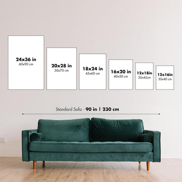
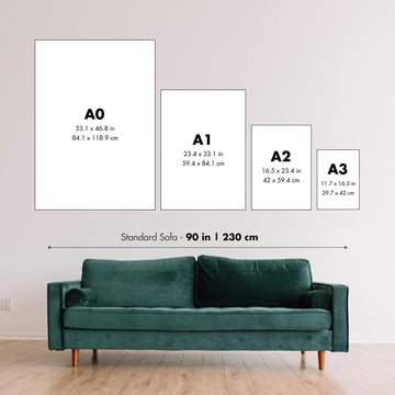
Diese Karte sieht in jeder Größe großartig aus, aber ich empfehle immer, eine größere Größe zu wählen, wenn Sie Platz haben. So können Sie alle Details leicht erkennen.
Diese Karte sieht bis zu 100 Zoll (250 cm) fantastisch aus. Wenn Sie nach einer größeren Karte suchen, bitte nehmen Sie Kontakt auf.
Bitte beachten Sie: Die Beschriftungen auf dieser Karte sind schwer zu lesen, wenn Sie eine Karte bestellen, die 16 Zoll (40 cm) oder kleiner ist. Die Karte ist immer noch sehr attraktiv, aber wenn Sie die Karte leicht lesen möchten, kaufen Sie bitte eine größere Größe.
Das Modell in den Listing-Bildern hält die 24x36 Zoll (60x90 cm) Version dieser Karte.
Das fünfte Listing-Bild zeigt ein Beispiel meines Karten-Personalisierungsdienstes.
Wenn Sie nach etwas leicht anderem suchen, schauen Sie sich meine Sammlung der besten alten Karten an. um zu sehen, ob etwas anderes Ihre Aufmerksamkeit erregt.
Bitte kontaktieren Sie mich, um zu überprüfen, ob ein bestimmter Ort, ein Wahrzeichen oder ein Merkmal auf dieser Karte angezeigt wird.
Dies wäre ein wunderbares Geburtstags-, Weihnachts-, Vatertags-, Abschieds-, Jubiläums- oder Einweihungsgeschenk für jemanden aus den von dieser Karte abgedeckten Gebieten.
Diese Karte ist als Giclée-Druck auf säurefreiem, archivierbarem mattem Papier erhältlich, oder Sie können sie gerahmt kaufen. Der Rahmen ist ein schöner, einfacher schwarzer Rahmen, der zu den meisten Ästhetiken passt. Bitte kontaktieren Sie mich, wenn Sie eine andere Rahmenfarbe oder -material wünschen. Meine Rahmen sind mit superklarem, museumstauglichem Acryl (Plexiglas/Acrylt) verglast, das erheblich weniger reflektierend ist als Glas, sicherer ist und immer in einwandfreiem Zustand ankommt.
This map is also available as a float framed canvas, sometimes known as a shadow gap framed canvas or canvas floater. The map is printed on artist's cotton canvas and then stretched over a handmade box frame. We then "float" the canvas inside a wooden frame, which is available in a range of colours (black, dark brown, oak, antique gold and white). This is a wonderful way to present a map without glazing in front. See some examples of float framed canvas maps and explore the differences between my different finishes.
For something truly unique, this map is also available in "Unique 3D", our trademarked process that dramatically transforms the map so that it has a wonderful sense of depth. We combine the original map with detailed topography and elevation data, so that mountains and the terrain really "pop". For more info and examples of 3D maps, check my Unique 3D page.
Für die meisten Bestellungen beträgt die Lieferzeit etwa 3 Werktage. Personalisierte und maßgeschneiderte Produkte benötigen länger, da ich die Personalisierung durchführen und sie Ihnen zur Genehmigung zusenden muss, was normalerweise 1 oder 2 Tage dauert.
Bitte beachten Sie, dass sehr große gerahmte Bestellungen in der Regel länger für die Herstellung und Lieferung benötigen.
Wenn Sie möchten, dass Ihre Bestellung bis zu einem bestimmten Datum ankommt, bitte kontaktieren Sie mich, bevor Sie bestellen, damit wir den besten Weg finden können, um sicherzustellen, dass Sie Ihre Bestellung rechtzeitig erhalten.
Ich drucke und rahme Karten und Kunstwerke in 23 Ländern weltweit. Das bedeutet, dass Ihre Bestellung lokal gefertigt wird, was die Lieferzeit verkürzt und sicherstellt, dass sie während der Lieferung nicht beschädigt wird. Sie zahlen nie Zoll oder Einfuhrgebühren, und wir stoßen weniger CO2 in die Luft aus.
Alle meine Karten und Kunstdrucke sind gut verpackt und werden in einem robusten Rohr versendet, wenn sie ungerahmt sind, oder von Schaum umgeben, wenn sie gerahmt sind.
Ich versuche, alle Bestellungen innerhalb von 1 oder 2 Tagen nach Erhalt Ihrer Bestellung zu versenden, obwohl einige Produkte (wie Gesichtsmasken, Tassen und Tragetaschen) länger zur Herstellung benötigen können.
Wenn Sie Express-Lieferung an der Kasse auswählen, priorisieren wir Ihre Bestellung und versenden sie per 1-Tages-Kurier (Fedex, DHL, UPS, Parcelforce).
Nächster Tag Lieferung ist auch in einigen Ländern verfügbar (USA, UK, Singapur, VAE), aber bitte versuchen Sie, früh am Tag zu bestellen, damit wir es rechtzeitig versenden können.
Lesen Sie meinen vollständigen Leitfaden zur Lieferung und lokalen Produktion
Mein Standardrahmen ist ein Galerie-Stil-Rahmen aus schwarzem Eschenholz. Er ist einfach und sieht ziemlich modern aus. Mein Standardrahmen ist etwa 20 mm (0,8 Zoll) breit.
Ich verwende super-klares Acryl (Plexiglas/Acrylt) für das Glas des Rahmens. Es ist leichter und sicherer als Glas – und es sieht besser aus, da die Reflexion geringer ist.
Sechs Standardrahmenfarben sind kostenlos erhältlich (schwarz, dunkelbraun, dunkelgrau, Eiche, weiß und antikgold).
Die meisten Karten, Kunstwerke und Illustrationen sind auch als gerahmte Leinwand erhältlich. Wir verwenden matte (nicht glänzende) Baumwollleinwand, spannen sie über einen nachhaltig beschafften Buchenrahmen und 'schweben' dann das Stück innerhalb eines Holzrahmens. Das Endergebnis ist ziemlich schön, und es gibt keine Verglasung, die im Weg ist.
Alle Rahmen werden "bereit zum Aufhängen" geliefert, entweder mit einer Schnur oder Halterungen auf der Rückseite. Sehr große Rahmen haben schwere Aufhängeplatten und/oder eine Montageschiene. Wenn Sie Fragen haben, können Sie bitte Kontakt aufnehmen.
Sehen Sie sich einige Beispiele meiner gerahmten Karten und gerahmten Leinwandkarten an.
Alternativ kann ich auch alte Karten und Kunstwerke auf Leinwand, Schaumstoffplatten, Baumwollrag und andere Materialien liefern.
Wenn Sie Ihre Karte oder Ihr Kunstwerk selbst rahmen möchten, lesen Sie bitte zuerst meinen Größenleitfaden.
Einige meiner alten Karten sind jetzt als gerahmte Leinwände erhältlich. Bitte kontaktiere mich, wenn du eine Größe bestellen möchtest, die in meinem Shop nicht verfügbar ist.
Leinwand alte Karten sind eine interessante Alternative zu konventionell gerahmten Karten. Je nach deinem persönlichen Geschmack und der Raumdekoration können Leinwandkarten etwas mehr „herausstechen“ als eine gerahmte Karte.
Meine Karten sind äußerst hochwertige Reproduktionen von Originalkarten.
Ich beziehe originale, seltene Karten aus Bibliotheken, Auktionshäusern und Privatsammlungen auf der ganzen Welt, restauriere sie in meiner Londoner Werkstatt und erstelle dann mit speziellen Giclée-Tinten und -Druckern wunderschöne Karten, die sogar noch besser aussehen als das Original.
Meine Karten werden auf säurefreiem, mattem Archivpapier (nicht glänzend) gedruckt, das sich sehr hochwertig anfühlt und fast wie Karton aussieht. Technisch gesehen beträgt das Papiergewicht/die Papierdicke 10mil/200g/m². Es eignet sich perfekt zum Einrahmen.
Ich drucke mit UV-lichtbeständigen Ultrachrome-Giclée-Pigmenttinten von Epson – einige der besten Tinten, die Sie finden können.
Ich kann auch machen Karten auf Leinwand, Baumwolllappen und andere exotische Materialien.
Erfahren Sie mehr über The Unique Maps Co.
Kartenpersonalisierung
Wenn Sie nach dem perfekten Geschenk zum Jahrestag oder zur Einweihung suchen, kann ich Ihre Karte personalisieren, um sie wirklich einzigartig zu machen. Ich kann beispielsweise eine kurze Nachricht hinzufügen, einen wichtigen Ort hervorheben oder das Wappen Ihrer Familie hinzufügen.
Die Möglichkeiten sind nahezu unbegrenzt. Bitte sehen Sie sich meine Kartenpersonalisierungsseite für einige wunderbare Beispiele dessen, was möglich ist.
Um eine personalisierte Karte zu bestellen, wählen Sie „Personalisieren Sie Ihre Karte“, bevor Sie sie in den Warenkorb legen.
In Kontakt kommen wenn Sie nach komplexeren Anpassungen und Personalisierungen suchen.
Kartenalterung
Im Laufe der Jahre wurde ich von Kunden hunderte Male gefragt, ob sie eine Karte kaufen könnten, die noch älter.
Nun, jetzt können Sie das, indem Sie „Alter“ auswählen, bevor Sie eine Karte in Ihren Warenkorb legen.
Alle Produktfotos, die Sie auf dieser Seite sehen, zeigen die Karte in ihrer Originalform. So sieht die Karte heute aus.
Wenn Sie „Gealtert“ auswählen, werde ich Ihre Karte von Hand altern lassen. Dazu verwende ich ein spezielles und einzigartiges Verfahren, das ich durch jahrelanges Studium alter Karten und Gespräche mit Forschern zum Verständnis der Chemie alternder Papiere entwickelt habe, und natürlich ... viel Übung!
Wenn Sie sich nicht sicher sind, bleiben Sie bei der Originalfarbe der Karte. Wenn Sie etwas Dunkleres und älter Wenn Sie auf der Suche sind, entscheiden Sie sich für „Aged“.
Sehen Sie einige erstaunliche Beispiele für gealterte Karten.
Wenn Sie aus irgendeinem Grund mit Ihrer Bestellung nicht zufrieden sind, kontaktieren Sie mich für eine unkomplizierte Rückerstattung. Bitte sehen Sie sich unsere Rückgabe- und Rückerstattungsrichtlinien für weitere Informationen an.
Ich bin sehr zuversichtlich, dass Ihnen Ihre restaurierte Karte oder Kunstdruck gefallen wird. Ich mache das seit 1984. Ich bin ein 5-Sterne Etsy-Verkäufer. Ich habe Zehntausende von Karten und Kunstdrucken verkauft und habe über 5.000 echte 5-Sterne-Bewertungen.
Ich verwende einen einzigartigen Prozess, um Karten und Kunstwerke zu restaurieren, der extrem zeitaufwendig und arbeitsintensiv ist. Die Suche nach den Originalkarten und Illustrationen kann Monate dauern. Ich benutze modernste und unglaublich teure Technologie, um sie zu scannen und wiederherzustellen. Daher garantiere ich, dass meine Karten und Kunstdrucke eine Klasse für sich sind - deshalb kann ich eine unkomplizierte Rückerstattung anbieten.
Fast alle meine Karten und Kunstdrucke sehen in großen Größen (200 cm, 6,5 Fuß+) erstaunlich aus und ich kann sie Ihnen auch gerahmt und über einen speziellen Übergrößen-Kurier liefern. Kontaktieren Sie mich, um Ihre speziellen Bedürfnisse zu besprechen.
Or try searching for something!


