


Old World Map of Protestant Missions, 1923: Christianity, Race & Religion Infographic, Gall Projection
20% off 2 — 33% off 3
Add any two eligible items to your bag to receive 20% off. Add a third and it will be complimentary (equivalent to 33% off when purchasing three).
No code needed — the offer applies automatically at checkout.
Valid on all standard maps and fine art prints. You can mix and match any designs.
If you’d like to ship items to multiple addresses, please contact us before placing your order.
Custom and bespoke commissions are excluded.
Contact us if you have any questions
-
![]() Handmade in the UK (we're based in London)
Handmade in the UK (we're based in London)

-
FREE worldwide delivery in 2-3 days ⓘ
Free delivery in 2-3 days
Your map should be delivered in 2-3 working days with free delivery, worldwide.
We make maps by hand locally in 23 countries, including the UK
![]() . If you're buying a gift for someone in another country, we will make the map locally to them.
. If you're buying a gift for someone in another country, we will make the map locally to them.You will never pay import tax or customs duty.
Express delivery is available at checkout which can reduce the delivery time to 1-2 days.
Please note that personalised maps, and larger framed maps, can take longer to produce and deliver.
If you need your order to arrive by a certain date, contact me and we can discuss your options.
-
Complimentary gifting & design advice
ⓘ
Complimentary gifting & design advice
Available almost 24/7 on WhatsApp and email — we usually reply within minutes. We can help you:
- Choose a perfectly personalised gift
- Send a digital gift preview to the recipient
- Pick the ideal size for your wall
- Select the right finish and frame
Quick, friendly advice so you can order with confidence.
For last minute gifts, consider buying a digital gift card. We have over 5,000 maps and art prints to choose from.
-
90-day returns & 5-year guarantee
ⓘ
90-day returns & 5-year guarantee
Products can be returned within 90 days for a full refund, or exchange for another product.
We are also proud to offer a 5-year quality guarantee on our maps and art, covering defects in materials or workmanship under normal use.
For personalised and custom made items, we may offer you store credit or a non-expiring gift card, as we cannot resell personalised orders.
If you have any questions, get in touch. For more information, see our full returns & exchanges policy.

This is a museum-grade archival print from the original 1923 map — restored in our workshop and made to order on 220gsm archival matte paper or 400gsm artist's cotton canvas with pigment inks.
Professional framing & free personalisation available.
1. Choose a size
2. Frame & personalise your map
Make your map unique with framing, hand-drawn customisation, vintage ageing, pop art text, unique 3D styling and more.


Gift message & custom finish

If you want to add a gift message, or a finish (jigsaw, aluminium board, etc.) that is not available here, please request it in the "order note" when you check out.
Every order is custom made, so if you need the size adjusted slightly, or printed on an unusual material, just let us know. We've done thousands of custom orders over the years, so there's (almost) nothing we can't manage.
You can also contact us before you order, if you prefer!

- Handmade locally. No import duty or tax
- FREE worldwide delivery
- 90-day returns & 5-year product guarantee
- Questions? WhatsApp me any time
Own a piece of history
7,000+ 5 star reviews


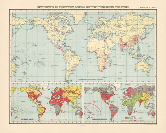
Embark on a journey through time with the captivating "Distribution of Protestant Mission Stations throughout the World," a map meticulously crafted in 1923 by the Institute of Social and Religious Research. This remarkable document not only charts the geographical spread of Protestant missions across the globe but also delves into the intricate tapestry of races and religions that painted the world during the early 20th century. The map's creation was driven by a desire to visualize the reach and impact of Protestantism, set against the backdrop of a world rapidly changing through colonialism, technological advancement, and the shifting sands of geopolitical boundaries. It stands as a testament to the era's complex interplay between faith, culture, and power.
The map is distinguished by its thematic design, employing a rich palette of colors to differentiate between regions based on religious dominance, racial demographics, and the density of missionary stations. This choice of design not only makes the map a visually striking piece but also a tool for understanding the global religious landscape of the time. The inclusion of smaller inset maps and illustrations, such as the distribution of races and prevailing religions, further enriches the narrative, offering insights into the societal structures and beliefs that shaped the world in 1923. The use of the Gall cartographic projection ensures that this visual narrative is conveyed with both accuracy and aesthetic appeal.
The historical significance of this map cannot be overstated. It serves as a window into the state of Protestant missions and the broader religious context of the early 20th century, highlighting the widespread influence of Christianity while also acknowledging the presence and persistence of other major world religions and belief systems. The map's detailed representation of the distribution of Protestant missions, alongside data on the percentage of Christians in each country and the number of Protestant missionaries, provides a unique snapshot of the missionary zeal that characterized the period.
Beyond its religious implications, the map is a rich historical document that offers insights into the geopolitical and social dynamics of the era. The extensive geographic coverage, from the vast expanses of Africa and Asia to the diverse landscapes of the Americas and the remote islands of the Pacific, reflects the global scale of missionary activities and the interconnectedness of the world. The detailed depiction of bodies of water and mountain ranges adds another layer of depth, inviting viewers to consider the natural barriers that missionaries had to navigate in their quest to spread their faith.
In summary, the "Distribution of Protestant Mission Stations throughout the World" is more than just a map; it is a historical artifact that captures the essence of a pivotal moment in world history. Its creation by the Institute of Social and Religious Research underscores the importance of understanding the global distribution of religions and their cultural implications. For collectors, historians, and anyone fascinated by the interplay between geography, religion, and history, this map is a treasure trove of insights, offering a unique perspective on the world as it was in 1923.
Countries and regions on this map
- Africa
- North America
- South America
- Europe
- Asia
- Australia
- New Zealand
- China
- India
- Japan
- Korea
- Burma
- Siam
- French Indo-China
- Dutch East Indies
- British East Indies
- Ceylon
- Persia
- Arabia
- Turkey
- Egypt
- North Africa
- West Africa
- Central Africa
- East Africa
- South Africa
- Madagascar
- Mauritius
- Reunion
- Seychelles
- Comoro Islands
- Socotra
- Cape Verde Islands
- Madeira
- Canary Islands
- Azores
- Bermuda
- Bahamas
- Turks and Caicos Islands
- Cayman Islands
- Jamaica
- Hispaniola
- Puerto Rico
- Virgin Islands
- Leeward Islands
- Windward Islands
- Barbados
- Trinidad and Tobago
- British Guiana
- Dutch Guiana
- French Guiana
- Venezuela
- Colombia
- Ecuador
- Peru
- Bolivia
- Chile
- Argentina
- Uruguay
- Paraguay
- Brazil
Notable Features & Landmarks
- Atlantic Ocean
- Pacific Ocean
- Indian Ocean
- Arctic Ocean
- Southern Ocean
- Mediterranean Sea
- Caribbean Sea
- North Sea
- Baltic Sea
- Black Sea
- Caspian Sea
- Lake Superior
- Lake Huron
- Lake Michigan
- Lake Erie
- Lake Ontario
- St. Lawrence River
- Mississippi River
- Amazon River
- Congo River
- Nile River
- Niger River
- Zambezi River
- Murray River
- Ganges River
- Indus River
- Yangtze River
- Yellow River
- Amur River
- Lena River
- Yenisei River
- Ob River
- Irtysh River
- Ural River
- Volga River
- Danube River
- Rhine River
- Elbe River
- Oder River
- Vistula River
- Dnieper River
- Don River
- Oka River
- Kama River
- Belaya River
- Ufa River
- Tobol River
- Ishim River
- Aldan River
- Sungari River
- Ussuri River
- Yalu River
- Liao River
- Hai River
- Wei River
- Fen River
- Huai River
- Han River
- Jiang River
- Min River
- Wu River
- Xiang River
- Gan River
- Bei River
- Qiantang River
- Pearl River
- Xi River
- Dong River
- Mekong River
- Salween River
- Irrawaddy River
- Brahmaputra River
- Yamuna River
- Sutlej River
- Chenab River
- Jhelum River
- Ravi River
- Beas River
- Son River
- Kosi River
- Gandak River
- Ghaghara River
- Chambal River
- Betwa River
- Ken River
- Tons River
- Narmada River
- Tapti River
- Godavari River
- Krishna River
- Bhima River
- Tungabhadra River
- Malaprabha River
- Ghataprabha River
- Koyna River
- Warna River
- Penganga River
- Wainganga River
- Indravati River
- Pranhita River
- Wardha River
- Mahanadi River
- Brahmani River
- Baitarani River
- Subarnarekha River
- Damodar River
- Ajay River
- Barakar River
- Kangsabati River
- Hooghly River
- Bhagirathi River
- Jalangi River
- Matla River
- Muri Ganga River
- Padma River
- Meghna River
- Barak River
- Tista River
- Jaldhaka River
- Raidak River
- Sankosh River
- Punatsangchu River
- Manas River
- Dhansiri River
- Kopili River
- Surma River
- Kusiyara River
- Gumti River
- Halda River
- Feni River
- Muhuri River
- Karnaphuli River
- Sangu River
- Matamuhuri River
- Naf River
- Arakan Yoma
- Pegu Yoma
- Shan Hills
- Annamite Range
- Cardamom Mountains
- Elephant Range
- Tenasserim Hills
- Bilauktaung Range
- Arakan Mountains
- Chin Hills
Historical and design context
- Title: Distribution of Protestant Mission Stations throughout the World
- Date: 1923
- Mapmaker/Publisher: Institute of Social and Religious Research
- Description: Shows the distribution of Protestant mission stations and the prevailing races and religions in different parts of the world.
- Topics and themes: Religion, Race, Colonialism
- Geographic coverage: The map covers the entire world.
- Design and style: Thematic map using different colors to show different topics and themes.
- Historical significance: Provides a snapshot of the state of Protestant missions and the prevailing races and religions around the world in 1923.
- Uses a Gall cartographic projection.
Please double check the images to make sure that a specific town or place is shown on this map. You can also get in touch and ask us to check the map for you.
This map looks great at every size, but I always recommend going for a larger size if you have space. That way you can easily make out all of the details.
This map looks amazing at sizes all the way up to 70in (180cm). If you are looking for a larger map, please get in touch.
The model in the listing images is holding the 16x20in (40x50cm) version of this map.
The fifth listing image shows an example of my map personalisation service.
If you’re looking for something slightly different, check out my collection of the best old maps to see if something else catches your eye.
Please contact me to check if a certain location, landmark or feature is shown on this map.
This would make a wonderful birthday, Christmas, Father's Day, work leaving, anniversary or housewarming gift for someone from the areas covered by this map.
This map is available as a giclée print on acid free archival matte paper, or you can buy it framed. The frame is a nice, simple black frame that suits most aesthetics. Please get in touch if you'd like a different frame colour or material. My frames are glazed with super-clear museum-grade acrylic (perspex/acrylite), which is significantly less reflective than glass, safer, and will always arrive in perfect condition.
This map is also available as a float framed canvas, sometimes known as a shadow gap framed canvas or canvas floater. The map is printed on artist's cotton canvas and then stretched over a handmade box frame. We then "float" the canvas inside a wooden frame, which is available in a range of colours (black, dark brown, oak, antique gold and white). This is a wonderful way to present a map without glazing in front. See some examples of float framed canvas maps and explore the differences between my different finishes.
For something truly unique, this map is also available in "Unique 3D", our trademarked process that dramatically transforms the map so that it has a wonderful sense of depth. We combine the original map with detailed topography and elevation data, so that mountains and the terrain really "pop". For more info and examples of 3D maps, check my Unique 3D page.
For most orders, delivery time is about 3 working days. Personalised and customised products take longer, as I have to do the personalisation and send it to you for approval, which usually takes 1 or 2 days.
Please note that very large framed orders usually take longer to make and deliver.
If you need your order to arrive by a certain date, please contact me before you order so that we can find the best way of making sure you get your order in time.
I print and frame maps and artwork in 23 countries around the world. This means your order will be made locally, which cuts down on delivery time and ensures that it won't be damaged during delivery. You'll never pay customs or import duty, and we'll put less CO2 into the air.
All of my maps and art prints are well packaged and sent in a rugged tube if unframed, or surrounded by foam if framed.
I try to send out all orders within 1 or 2 days of receiving your order, though some products (like face masks, mugs and tote bags) can take longer to make.
If you select Express Delivery at checkout your order we will prioritise your order and send it out by 1-day courier (Fedex, DHL, UPS, Parcelforce).
Next Day delivery is also available in some countries (US, UK, Singapore, UAE) but please try to order early in the day so that we can get it sent out on time.
My standard frame is a gallery style black ash hardwood frame. It is simple and quite modern looking. My standard frame is around 20mm (0.8in) wide.
I use super-clear acrylic (perspex/acrylite) for the frame glass. It's lighter and safer than glass - and it looks better, as the reflectivity is lower.
Six standard frame colours are available for free (black, dark brown, dark grey, oak, white and antique gold). Custom framing and mounting/matting is available if you're looking for something else.
Most maps, art and illustrations are also available as a framed canvas. We use matte (not shiny) cotton canvas, stretch it over a sustainably sourced box wood frame, and then 'float' the piece within a wood frame. The end result is quite beautiful, and there's no glazing to get in the way.
All frames are provided "ready to hang", with either a string or brackets on the back. Very large frames will have heavy duty hanging plates and/or a mounting baton. If you have any questions, please get in touch.
See some examples of my framed maps and framed canvas maps.
Alternatively, I can also supply old maps and artwork on canvas, foam board, cotton rag and other materials.
If you want to frame your map or artwork yourself, please read my size guide first.
My maps are extremely high quality reproductions of original maps.
I source original, rare maps from libraries, auction houses and private collections around the world, restore them at my London workshop, and then use specialist giclée inks and printers to create beautiful maps that look even better than the original.
My maps are printed on acid-free archival matte (not glossy) paper that feels very high quality and almost like card. In technical terms the paper weight/thickness is 10mil/200gsm. It's perfect for framing.
I print with Epson ultrachrome giclée UV fade resistant pigment inks - some of the best inks you can find.
I can also make maps on canvas, cotton rag and other exotic materials.
Learn more about The Unique Maps Co.
Map personalisation
If you're looking for the perfect anniversary or housewarming gift, I can personalise your map to make it truly unique. For example, I can add a short message, or highlight an important location, or add your family's coat of arms.
The options are almost infinite. Please see my map personalisation page for some wonderful examples of what's possible.
To order a personalised map, select "personalise your map" before adding it to your basket.
Get in touch if you're looking for more complex customisations and personalisations.
Map ageing
I have been asked hundreds of times over the years by customers if they could buy a map that looks even older.
Well, now you can, by selecting Aged before you add a map to your basket.
All the product photos you see on this page show the map in its Original form. This is what the map looks like today.
If you select Aged, I will age your map by hand, using a special and unique process developed through years of studying old maps, talking to researchers to understand the chemistry of aging paper, and of course... lots of practice!
If you're unsure, stick to the Original colour of the map. If you want something a bit darker and older looking, go for Aged.
If you are not happy with your order for any reason, contact me and I'll get it fixed ASAP, free of charge. Please see my returns and refund policy for more information.
I am very confident you will like your restored map or art print. I have been doing this since 1984. I'm a 5-star Etsy seller. I have sold tens of thousands of maps and art prints and have over 5,000 real 5-star reviews. My work has been featured in interior design magazines, on the BBC, and on the walls of dozens of 5-star hotels.
I use a unique process to restore maps and artwork that is massively time consuming and labour intensive. Hunting down the original maps and illustrations can take months. I use state of the art and eye-wateringly expensive technology to scan and restore them. As a result, I guarantee my maps and art prints are a cut above the rest. I stand by my products and will always make sure you're 100% happy with what you receive.
Almost all of my maps and art prints look amazing at large sizes (200cm, 6.5ft+) and I can frame and deliver them to you as well, via special oversized courier. Contact me to discuss your specific needs.
Or try searching for something!


