


Old Map of Compagnie Generale Transatlantique by Blondel La Rougery, 1970: Shipping Routes, Liners
20% off 2 — 33% off 3
Add any two eligible items to your bag to receive 20% off. Add a third and it will be complimentary (equivalent to 33% off when purchasing three).
No code needed — the offer applies automatically at checkout.
Valid on all standard maps and fine art prints. You can mix and match any designs.
If you’d like to ship items to multiple addresses, please contact us before placing your order.
Custom and bespoke commissions are excluded.
Contact us if you have any questions
-
![]() Handmade in the UK (we're based in London)
Handmade in the UK (we're based in London)

-
FREE worldwide delivery in 2-3 days ⓘ
Free delivery in 2-3 days
Your map should be delivered in 2-3 working days with free delivery, worldwide.
We make maps by hand locally in 23 countries, including the UK
![]() . If you're buying a gift for someone in another country, we will make the map locally to them.
. If you're buying a gift for someone in another country, we will make the map locally to them.You will never pay import tax or customs duty.
Express delivery is available at checkout which can reduce the delivery time to 1-2 days.
Please note that personalised maps, and larger framed maps, can take longer to produce and deliver.
If you need your order to arrive by a certain date, contact me and we can discuss your options.
-
Complimentary gifting & design advice
ⓘ
Complimentary gifting & design advice
Available almost 24/7 on WhatsApp and email — we usually reply within minutes. We can help you:
- Choose a perfectly personalised gift
- Send a digital gift preview to the recipient
- Pick the ideal size for your wall
- Select the right finish and frame
Quick, friendly advice so you can order with confidence.
For last minute gifts, consider buying a digital gift card. We have over 5,000 maps and art prints to choose from.
-
90-day returns & 5-year guarantee
ⓘ
90-day returns & 5-year guarantee
Products can be returned within 90 days for a full refund, or exchange for another product.
We are also proud to offer a 5-year quality guarantee on our maps and art, covering defects in materials or workmanship under normal use.
For personalised and custom made items, we may offer you store credit or a non-expiring gift card, as we cannot resell personalised orders.
If you have any questions, get in touch. For more information, see our full returns & exchanges policy.

This is a museum-grade archival print from the original 1970 map — restored in our workshop and made to order on 220gsm archival matte paper or 400gsm artist's cotton canvas with pigment inks.
Professional framing & free personalisation available.
1. Choose a size
2. Frame & personalise your map
Make your map unique with framing, hand-drawn customisation, vintage ageing, pop art text, unique 3D styling and more.


Gift message & custom finish

If you want to add a gift message, or a finish (jigsaw, aluminium board, etc.) that is not available here, please request it in the "order note" when you check out.
Every order is custom made, so if you need the size adjusted slightly, or printed on an unusual material, just let us know. We've done thousands of custom orders over the years, so there's (almost) nothing we can't manage.
You can also contact us before you order, if you prefer!

- Handmade locally. No import duty or tax
- FREE worldwide delivery
- 90-day returns & 5-year product guarantee
- Questions? WhatsApp me any time
Own a piece of history
7,000+ 5 star reviews


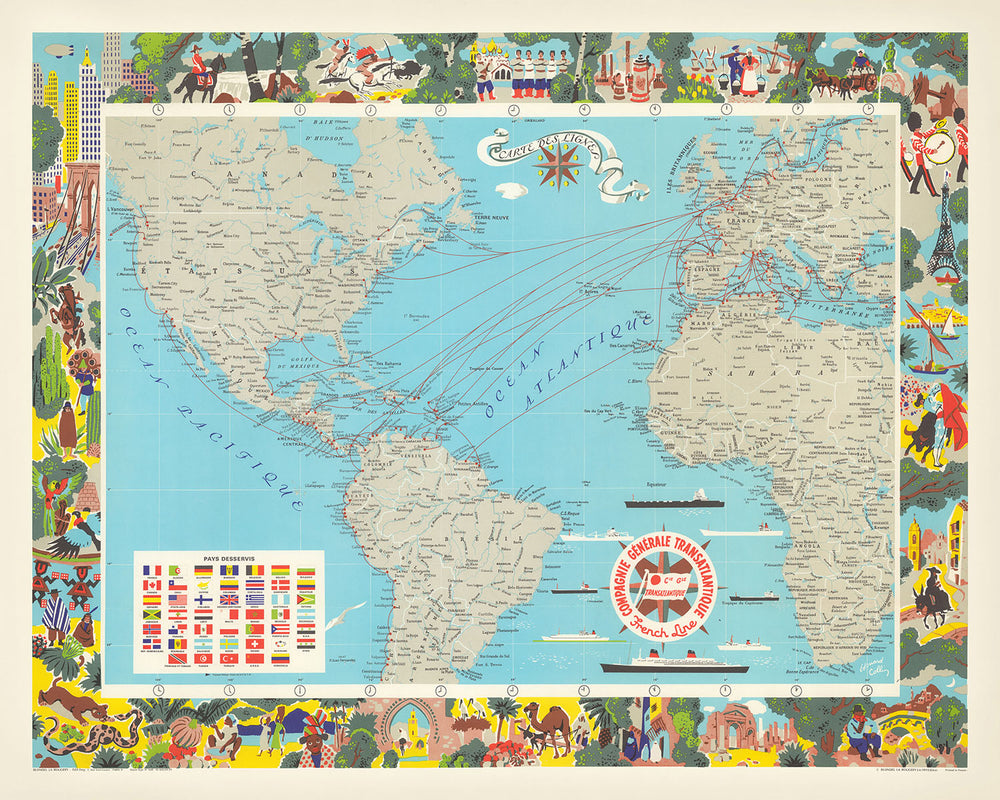
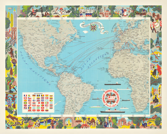
The "Carte des lignes. Compagnie Generale Transatlantique. French line," crafted by Max Blondel La Rougery in 1970, is a stunning representation of a bygone era in maritime history. This thematic and pictorial map was published in Paris and serves as a visual testament to the global reach of the Compagnie Generale Transatlantique, a French shipping company established in 1855. The map is adorned with intricate illustrations, including a compass rose and five illustrious liners, encapsulating the grandeur and prestige of the company’s fleet, which gained international fame with vessels like the Paris, Ile-de-France, and the legendary Normandie.
This map is not merely a navigational tool but a work of art that captures the essence of international travel in the mid-20th century. Highlighting the shipping lines in red, it showcases the extensive routes that connected North America, the West Indies, Europe, and parts of Africa and Asia. The map also delineates main airline routes and transatlantic hotels, illustrating the comprehensive network of travel options available at the time. The decorative borders, featuring scenes and characters from various countries, add a cultural richness that enhances its visual appeal and historical significance.
Max Blondel La Rougery, the mastermind behind this map, succeeded his father Edouard Blondel La Rougery in directing the family publishing house. The Blondel La Rougery Editions, founded in 1902, were renowned for their detailed and artistic maps, including a monumental bird's-eye view of Paris. Max continued this legacy, and his work on this map reflects a deep understanding of cartography combined with an artistic flair that makes this piece both informative and aesthetically pleasing.
The map’s design is a harmonious blend of functionality and artistry. The use of vibrant colors to highlight shipping routes and the inclusion of national flags and a table of countries served by the Compagnie Generale Transatlantique add layers of information that are both engaging and educational. The pictorial elements, such as the illustrations of liners and cultural scenes, provide a narrative that goes beyond geographical data, offering a glimpse into the world of international travel and trade during the mid-20th century.
Historically, this map is significant as it marks the twilight years of the Compagnie Generale Transatlantique before its merger with the Compagnie des Messageries Maritimes in 1975. It captures a moment in time when maritime travel was a luxurious and prestigious mode of transportation, soon to be overshadowed by the rise of air travel. This map is not just a representation of routes and destinations; it is a piece of history that tells the story of a company that played a pivotal role in connecting continents and cultures through the power of the sea.
Countries and regions on this map
- North America:
- United States
- Canada
- Mexico
- South America:
- Brazil
- Argentina
- Chile
- Peru
- Venezuela
- Colombia
- Uruguay
- Paraguay
- Ecuador
- Bolivia
- Europe:
- United Kingdom
- France
- Spain
- Portugal
- Italy
- Germany
- Netherlands
- Belgium
- Switzerland
- Sweden
- Norway
- Denmark
- Finland
- Poland
- Austria
- Hungary
- Czechoslovakia (modern-day Czech Republic and Slovakia)
- Yugoslavia (modern-day Slovenia, Croatia, Bosnia and Herzegovina, Montenegro, North Macedonia, Serbia, and Kosovo)
- Greece
- Turkey
- Soviet Union (including modern-day Russia, Baltic states, and other former Soviet republics)
- Africa:
- Morocco
- Algeria
- Tunisia
- Egypt
- Senegal
- Ivory Coast
- Ghana
- Nigeria
- Cameroon
- Democratic Republic of the Congo
- Kenya
- Tanzania
- South Africa
- Asia:
- Middle East regions including Israel, Lebanon, and Syria
Notable Features & Landmarks
- Smaller inset maps or additional illustrations outside the map:
- Illustrations of five liners.
- Decorative border with scenes and characters from various countries.
- French flag and a table of countries served with their respective flags.
- Bodies of water:
- Atlantic Ocean (Océan Atlantique)
- Pacific Ocean (Océan Pacifique)
- Indian Ocean (Océan Indien)
- Sea routes:
- Shipping lines highlighted in red.
- Other interesting features:
- Compass rose.
- Transatlantic hotels.
- Main airline routes.
Historical and design context
- Mapmaker or publisher: Max Blondel La Rougery
- The Blondel La Rougery Editions were founded in 1902 by Edouard Blondel La Rougery.
- Max Blondel La Rougery succeeded Edouard around 1955 and directed the company until 1976.
- Topics and themes shown on the map:
- Shipping lines, main airline routes, and transatlantic hotels.
- The map highlights connections to the American continent, the West Indies, Europe, and parts of Africa and Asia.
- Adorned with a compass rose, illustrations of liners, and a French flag.
- Features a table of countries served along with their respective flags.
- The borders are decorated with scenes and characters depicting various countries served by the shipping lines.
- Design or style of the map:
- Thematic and pictorial, with decorative elements including illustrations of ships, flags, and cultural scenes.
- Historical significance or context:
- Reflects the global reach and importance of the Compagnie Generale Transatlantique before the rise of air travel.
- Illustrates the historical context of international shipping routes and the cultural connections facilitated by maritime travel.
Please double check the images to make sure that a specific town or place is shown on this map. You can also get in touch and ask us to check the map for you.
This map looks great at every size, but I always recommend going for a larger size if you have space. That way you can easily make out all of the details.
This map looks amazing at sizes all the way up to 100in (250cm). If you are looking for a larger map, please get in touch.
Please note: the labels on this map are hard to read if you order a map that is 16in (40cm) or smaller. The map is still very attractive, but if you would like to read the map easily, please buy a larger size.
The model in the listing images is holding the 16x20in (40x50cm) version of this map.
The fifth listing image shows an example of my map personalisation service.
If you’re looking for something slightly different, check out my collection of the best old maps to see if something else catches your eye.
Please contact me to check if a certain location, landmark or feature is shown on this map.
This would make a wonderful birthday, Christmas, Father's Day, work leaving, anniversary or housewarming gift for someone from the areas covered by this map.
This map is available as a giclée print on acid free archival matte paper, or you can buy it framed. The frame is a nice, simple black frame that suits most aesthetics. Please get in touch if you'd like a different frame colour or material. My frames are glazed with super-clear museum-grade acrylic (perspex/acrylite), which is significantly less reflective than glass, safer, and will always arrive in perfect condition.
This map is also available as a float framed canvas, sometimes known as a shadow gap framed canvas or canvas floater. The map is printed on artist's cotton canvas and then stretched over a handmade box frame. We then "float" the canvas inside a wooden frame, which is available in a range of colours (black, dark brown, oak, antique gold and white). This is a wonderful way to present a map without glazing in front. See some examples of float framed canvas maps and explore the differences between my different finishes.
For something truly unique, this map is also available in "Unique 3D", our trademarked process that dramatically transforms the map so that it has a wonderful sense of depth. We combine the original map with detailed topography and elevation data, so that mountains and the terrain really "pop". For more info and examples of 3D maps, check my Unique 3D page.
For most orders, delivery time is about 3 working days. Personalised and customised products take longer, as I have to do the personalisation and send it to you for approval, which usually takes 1 or 2 days.
Please note that very large framed orders usually take longer to make and deliver.
If you need your order to arrive by a certain date, please contact me before you order so that we can find the best way of making sure you get your order in time.
I print and frame maps and artwork in 23 countries around the world. This means your order will be made locally, which cuts down on delivery time and ensures that it won't be damaged during delivery. You'll never pay customs or import duty, and we'll put less CO2 into the air.
All of my maps and art prints are well packaged and sent in a rugged tube if unframed, or surrounded by foam if framed.
I try to send out all orders within 1 or 2 days of receiving your order, though some products (like face masks, mugs and tote bags) can take longer to make.
If you select Express Delivery at checkout your order we will prioritise your order and send it out by 1-day courier (Fedex, DHL, UPS, Parcelforce).
Next Day delivery is also available in some countries (US, UK, Singapore, UAE) but please try to order early in the day so that we can get it sent out on time.
My standard frame is a gallery style black ash hardwood frame. It is simple and quite modern looking. My standard frame is around 20mm (0.8in) wide.
I use super-clear acrylic (perspex/acrylite) for the frame glass. It's lighter and safer than glass - and it looks better, as the reflectivity is lower.
Six standard frame colours are available for free (black, dark brown, dark grey, oak, white and antique gold). Custom framing and mounting/matting is available if you're looking for something else.
Most maps, art and illustrations are also available as a framed canvas. We use matte (not shiny) cotton canvas, stretch it over a sustainably sourced box wood frame, and then 'float' the piece within a wood frame. The end result is quite beautiful, and there's no glazing to get in the way.
All frames are provided "ready to hang", with either a string or brackets on the back. Very large frames will have heavy duty hanging plates and/or a mounting baton. If you have any questions, please get in touch.
See some examples of my framed maps and framed canvas maps.
Alternatively, I can also supply old maps and artwork on canvas, foam board, cotton rag and other materials.
If you want to frame your map or artwork yourself, please read my size guide first.
My maps are extremely high quality reproductions of original maps.
I source original, rare maps from libraries, auction houses and private collections around the world, restore them at my London workshop, and then use specialist giclée inks and printers to create beautiful maps that look even better than the original.
My maps are printed on acid-free archival matte (not glossy) paper that feels very high quality and almost like card. In technical terms the paper weight/thickness is 10mil/200gsm. It's perfect for framing.
I print with Epson ultrachrome giclée UV fade resistant pigment inks - some of the best inks you can find.
I can also make maps on canvas, cotton rag and other exotic materials.
Learn more about The Unique Maps Co.
Map personalisation
If you're looking for the perfect anniversary or housewarming gift, I can personalise your map to make it truly unique. For example, I can add a short message, or highlight an important location, or add your family's coat of arms.
The options are almost infinite. Please see my map personalisation page for some wonderful examples of what's possible.
To order a personalised map, select "personalise your map" before adding it to your basket.
Get in touch if you're looking for more complex customisations and personalisations.
Map ageing
I have been asked hundreds of times over the years by customers if they could buy a map that looks even older.
Well, now you can, by selecting Aged before you add a map to your basket.
All the product photos you see on this page show the map in its Original form. This is what the map looks like today.
If you select Aged, I will age your map by hand, using a special and unique process developed through years of studying old maps, talking to researchers to understand the chemistry of aging paper, and of course... lots of practice!
If you're unsure, stick to the Original colour of the map. If you want something a bit darker and older looking, go for Aged.
If you are not happy with your order for any reason, contact me and I'll get it fixed ASAP, free of charge. Please see my returns and refund policy for more information.
I am very confident you will like your restored map or art print. I have been doing this since 1984. I'm a 5-star Etsy seller. I have sold tens of thousands of maps and art prints and have over 5,000 real 5-star reviews. My work has been featured in interior design magazines, on the BBC, and on the walls of dozens of 5-star hotels.
I use a unique process to restore maps and artwork that is massively time consuming and labour intensive. Hunting down the original maps and illustrations can take months. I use state of the art and eye-wateringly expensive technology to scan and restore them. As a result, I guarantee my maps and art prints are a cut above the rest. I stand by my products and will always make sure you're 100% happy with what you receive.
Almost all of my maps and art prints look amazing at large sizes (200cm, 6.5ft+) and I can frame and deliver them to you as well, via special oversized courier. Contact me to discuss your specific needs.
Or try searching for something!


