


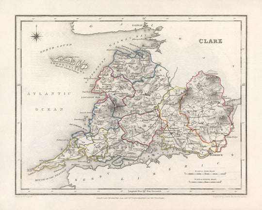


Old Map of County Clare by Samuel Lewis, 1844: Ennis, Kilrush, Shannon Estuary, Loop Head Peninsula, and Burren Landscape

-
![]() Handmade in the UK (we're based in London)
Handmade in the UK (we're based in London)
-
FREE worldwide delivery in 2-3 days ⓘ
Free Christmas delivery in 2-3 days
Your map should be delivered in 2-3 working days with free delivery, worldwide.
We make maps by hand locally in 23 countries, including the UK
![]() . If you're buying a gift for someone in another country, we will make the map locally to them.
. If you're buying a gift for someone in another country, we will make the map locally to them.You will never pay import tax or customs duty.
Check the Christmas delivery guide for order deadlines.
Express delivery is available at checkout which can reduce the delivery time to 1-2 days.
Please note that personalised maps, and larger framed maps, can take longer to produce and deliver.
If you need your order to arrive by a certain date, contact me and we can discuss your options.
-
90 day money back guarantee
ⓘ
90 days to return and refund
Products can be returned within 90 days for a full refund, or exchange for another product.
For personalised and custom made items, we may offer you store credit or a non-expiring gift card, as we cannot resell personalised orders.
If you have any questions, get in touch. For more information, see our full returns & exchanges policy.

My maps are rare, museum-grade, restored old maps sourced from libraries, auction houses and private collections across the globe.
Framing & free personalisation available
1. Select your size
2. Frame & personalise your map
Make your map unique with framing, hand-drawn customisation, vintage ageing, pop art text, unique 3D styling and moreGift message & custom finish

If you want to add a gift message, or a finish (jigsaw, aluminium board, etc.) that is not available here, please request it in the "order note" when you check out.
Every order is custom made, so if you need the size adjusted slightly, or printed on an unusual material, just let us know. We've done thousands of custom orders over the years, so there's (almost) nothing we can't manage.
You can also contact us before you order, if you prefer!

- Handmade locally. No import duty or tax
- FREE Delivery. Arrives in 2-3 days
- Love it or your money back
- Questions? WhatsApp me any time
Own a piece of history
5,000+ 5 star reviews


This Old Map of Clare by Samuel Lewis in 1844 showcases the historical boundaries of County Clare, Ireland, providing a fascinating glimpse into the past. With its intricate details and exquisite craftsmanship, this map is a captivating piece of history that will enhance any collection or adorn any wall.
The map presents a unique opportunity to explore the major towns, cities, and notable features of County Clare in 1844. While some modern cities may not be depicted, or may appear under earlier names, this only adds to the allure of the map. It allows you to discover the region as it was known during the mid-19th century, offering a valuable perspective on the historical development of Clare.
Notable features on this map include Ennis, the county town of Clare, with its rich medieval history and charming streets. Kilrush, an important trading port on the Shannon Estuary, is also showcased, highlighting its maritime significance. The map further encompasses the stunning Loop Head Peninsula, renowned for its rugged cliffs and picturesque lighthouses. Lastly, the Burren Landscape, with its unique karst terrain and ancient archaeological sites, adds an element of intrigue to this historical representation.
Settlements Founded Before 1840 within County Clare:- Ennis (1240): County town of Clare, known for its medieval history and vibrant culture.- Kilrush (circa 1760): Thriving trading port on the Shannon Estuary, historically significant for its maritime activities.- Shannon (1939): Originally known as Newmarket-on-Fergus, it was renamed Shannon in 1939 due to the establishment of Shannon Airport.- Sixmilebridge (1812): A picturesque village situated on the banks of the River Fergus.- Newmarket-on-Fergus (1318): A historic village with strong ties to the O'Brien clan, offering a glimpse into medieval Ireland.- Lahinch (circa 1800): A popular seaside resort renowned for its sandy beach and world-class surfing.- Scariff (circa 1750): A charming market town located on the shores of Lough Derg, offering scenic beauty and historical interest.- Kilkee (circa 1760): A coastal town famous for its Victorian seaside resort heritage and stunning cliffs.- Miltown Malbay (circa 1800): A vibrant town known for its traditional Irish music heritage and annual Willie Clancy Summer School.- Quin (circa 1280): Home to the striking ruins of Quin Abbey, this village is steeped in history and architectural beauty.- Tulla (circa 1610): A picturesque village situated on the banks of the River Graney, known for its traditional music scene.- Corofin (circa 1800): Nestled amidst scenic landscapes, this village offers access to the stunning Burren region.- Kilfenora (circa 1200): Known as the "City of the Crosses," this village boasts a rich ecclesiastical heritage and ancient Celtic crosses.- Kildysart (circa 1812): A tranquil village located on the Shannon Estuary, offering picturesque views and a peaceful atmosphere.- Cratloe (circa 1200): Home to the historic Cratloe Woods, this village is renowned for its natural beauty and outdoor recreational opportunities.- Doonbeg (circa 1802): A coastal village known for its beautiful beach and proximity to the Trump International Golf Links.- Feakle (circa 1610): Famous for its traditional music festival, this village is nestled in the scenic East Clare countryside.- Whitegate (circa 1830): A charming village situated on Lough Derg, offering stunning views and a tranquil atmosphere.- Broadford (circa 1800): A picturesque village surrounded by rolling hills and scenic beauty.- Parteen (circa 1800): Located on the banks of the River Shannon, this village offers idyllic riverside views and recreational opportunities.- O'Briensbridge (circa 1800): Known for its picturesque bridge over the River Shannon, this village provides a tranquil setting for visitors.- Mountshannon (circa 1810): Situated on the shores of Lough Derg, this village offers breathtaking views and access to the East Clare Way.- Liscannor (circa 1800): A coastal village renowned for its proximity to the Cliffs of Moher and traditional fishing heritage.- Quilty (circa 1800): A scenic village located on the Wild Atlantic Way, offering stunning coastal views and a peaceful ambiance.- Ballyvaughan (circa 1800): Nestled in the heart of the Burren, this village provides a gateway to the unique karst landscape.- Kilrush (circa 1760): A picturesque village situated on the banks of the River Shannon, historically significant for its maritime activities.- Lisdoonvarna (circa 1800): Famous for its annual matchmaking festival, this village is surrounded by breathtaking natural beauty.- Spanish Point (circa 1800): A coastal village known for its sandy beach and connection to the Spanish Armada shipwrecks.- Bridgetown (circa 1800): Located on the Loop Head Peninsula, this village offers stunning coastal views and a tranquil atmosphere.- Carrigaholt (circa 1800): A charming village with a rich maritime history and a picturesque castle overlooking the Shannon Estuary.- Labasheeda (circa 1800): Situated on the banks of the River Shannon, this village offers scenic beauty and a peaceful ambiance.
Notable Boundaries, Rivers, and Natural Phenomena:- Shannon Estuary: A scenic estuary formed by the River Shannon, renowned for its diverse wildlife and picturesque landscapes.- Loop Head Peninsula: A stunning peninsula characterized by dramatic cliffs, historic lighthouses, and breathtaking coastal scenery.- Burren Landscape: A unique karst region known for its limestone pavements, rare flora, and ancient archaeological sites.- Cliffs of Moher: Majestic cliffs rising over 700 feet above the Atlantic Ocean, offering awe-inspiring views and dramatic coastal scenery.- Lough Derg: A picturesque lake located on the River Shannon, known for its tranquil waters and scenic beauty.
Historical Events in County Clare between 1800 and 1850:- 1803: The Battle of Killaloe took place during the Irish Rebellion of 1803, resulting in the defeat of the rebels by British forces.- 1828: The construction of the Shannon Scheme, a major hydroelectric project, began in Clare, transforming the region's energy infrastructure.- 1849: The Great Famine deeply impacted County Clare, leading to widespread poverty, emigration, and loss of life.
Own a piece of history with this Old Map of Clare by Samuel Lewis in 1844. Explore the past, uncover forgotten towns, and marvel at the beauty of County Clare as it was over a century ago.
Please double check the images to make sure that a specific town or place is shown on this map. You can also get in touch and ask us to check the map for you.
This map looks great at all sizes: 12x16in (30.5x41cm), 16x20in (40.5x51cm), 18x24in (45.5x61cm), 24x30in (61x76cm), 32x40in (81.5x102cm) and 40x50in (102x127cm), but it looks even better when printed large.
I can create beautiful, large prints of this map up to 50in (127cm). Please get in touch if you're looking for larger, customised or different framing options.
The model in the listing images is holding the 16x20in (40.5x51cm) version of this map.
The fifth listing image shows an example of my map personalisation service.
If you’re looking for something slightly different, check out my main collection of UK and Ireland maps.
Please contact me to check if a certain location, landmark or feature is shown on this map.
This would make a wonderful birthday, Christmas, Father's Day, work leaving, anniversary or housewarming gift for someone from the areas covered by this map.
This map is available as a giclée print on acid free archival matte paper, or you can buy it framed. The frame is a nice, simple black frame that suits most aesthetics. Please get in touch if you'd like a different frame colour or material. My frames are glazed with super-clear museum-grade acrylic (perspex/acrylite), which is significantly less reflective than glass, safer, and will always arrive in perfect condition.
This map is also available as a float framed canvas, sometimes known as a shadow gap framed canvas or canvas floater. The map is printed on artist's cotton canvas and then stretched over a handmade box frame. We then "float" the canvas inside a wooden frame, which is available in a range of colours (black, dark brown, oak, antique gold and white). This is a wonderful way to present a map without glazing in front. See some examples of float framed canvas maps and explore the differences between my different finishes.
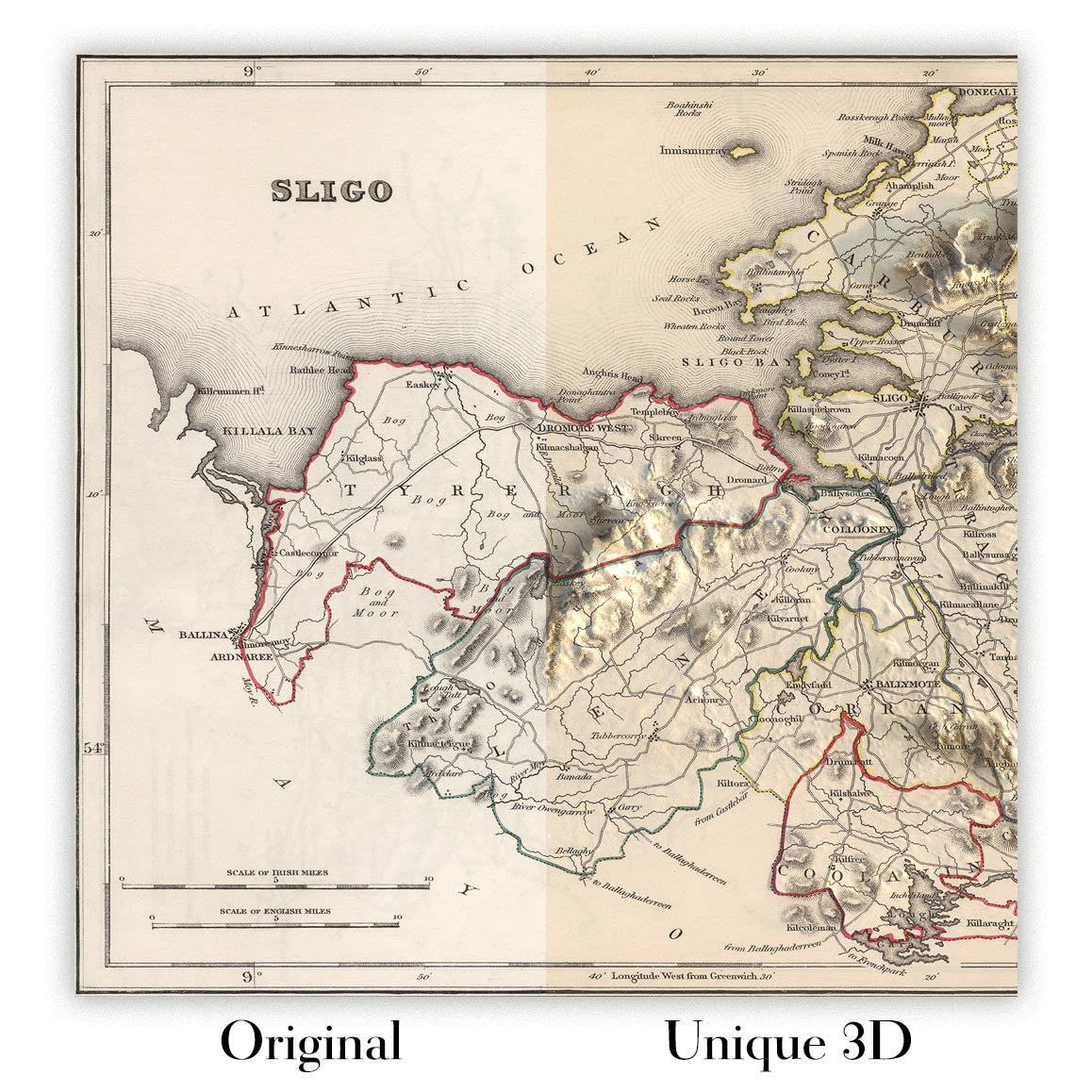
For something truly unique, this map is also available in "Unique 3D", our trademarked process that dramatically transforms the map so that it has a wonderful sense of depth. We combine the original map with detailed topography and elevation data, so that mountains and the terrain really "pop". For more info and examples of 3D maps, check my Unique 3D page.
For most orders, delivery time is about 3 working days. Personalised and customised products take longer, as I have to do the personalisation and send it to you for approval, which usually takes 1 or 2 days.
Please note that very large framed orders usually take longer to make and deliver.
If you need your order to arrive by a certain date, please contact me before you order so that we can find the best way of making sure you get your order in time.
I print and frame maps and artwork in 23 countries around the world. This means your order will be made locally, which cuts down on delivery time and ensures that it won't be damaged during delivery. You'll never pay customs or import duty, and we'll put less CO2 into the air.
All of my maps and art prints are well packaged and sent in a rugged tube if unframed, or surrounded by foam if framed.
I try to send out all orders within 1 or 2 days of receiving your order, though some products (like face masks, mugs and tote bags) can take longer to make.
If you select Express Delivery at checkout your order we will prioritise your order and send it out by 1-day courier (Fedex, DHL, UPS, Parcelforce).
Next Day delivery is also available in some countries (US, UK, Singapore, UAE) but please try to order early in the day so that we can get it sent out on time.
My standard frame is a gallery style black ash hardwood frame. It is simple and quite modern looking. My standard frame is around 20mm (0.8in) wide.
I use super-clear acrylic (perspex/acrylite) for the frame glass. It's lighter and safer than glass - and it looks better, as the reflectivity is lower.
Six standard frame colours are available for free (black, dark brown, dark grey, oak, white and antique gold). Custom framing and mounting/matting is available if you're looking for something else.
Most maps, art and illustrations are also available as a framed canvas. We use matte (not shiny) cotton canvas, stretch it over a sustainably sourced box wood frame, and then 'float' the piece within a wood frame. The end result is quite beautiful, and there's no glazing to get in the way.
All frames are provided "ready to hang", with either a string or brackets on the back. Very large frames will have heavy duty hanging plates and/or a mounting baton. If you have any questions, please get in touch.
See some examples of my framed maps and framed canvas maps.
Alternatively, I can also supply old maps and artwork on canvas, foam board, cotton rag and other materials.
If you want to frame your map or artwork yourself, please read my size guide first.
My maps are extremely high quality reproductions of original maps.
I source original, rare maps from libraries, auction houses and private collections around the world, restore them at my London workshop, and then use specialist giclée inks and printers to create beautiful maps that look even better than the original.
My maps are printed on acid-free archival matte (not glossy) paper that feels very high quality and almost like card. In technical terms the paper weight/thickness is 10mil/200gsm. It's perfect for framing.
I print with Epson ultrachrome giclée UV fade resistant pigment inks - some of the best inks you can find.
I can also make maps on canvas, cotton rag and other exotic materials.
Learn more about The Unique Maps Co.
Map personalisation
If you're looking for the perfect anniversary or housewarming gift, I can personalise your map to make it truly unique. For example, I can add a short message, or highlight an important location, or add your family's coat of arms.
The options are almost infinite. Please see my map personalisation page for some wonderful examples of what's possible.
To order a personalised map, select "personalise your map" before adding it to your basket.
Get in touch if you're looking for more complex customisations and personalisations.
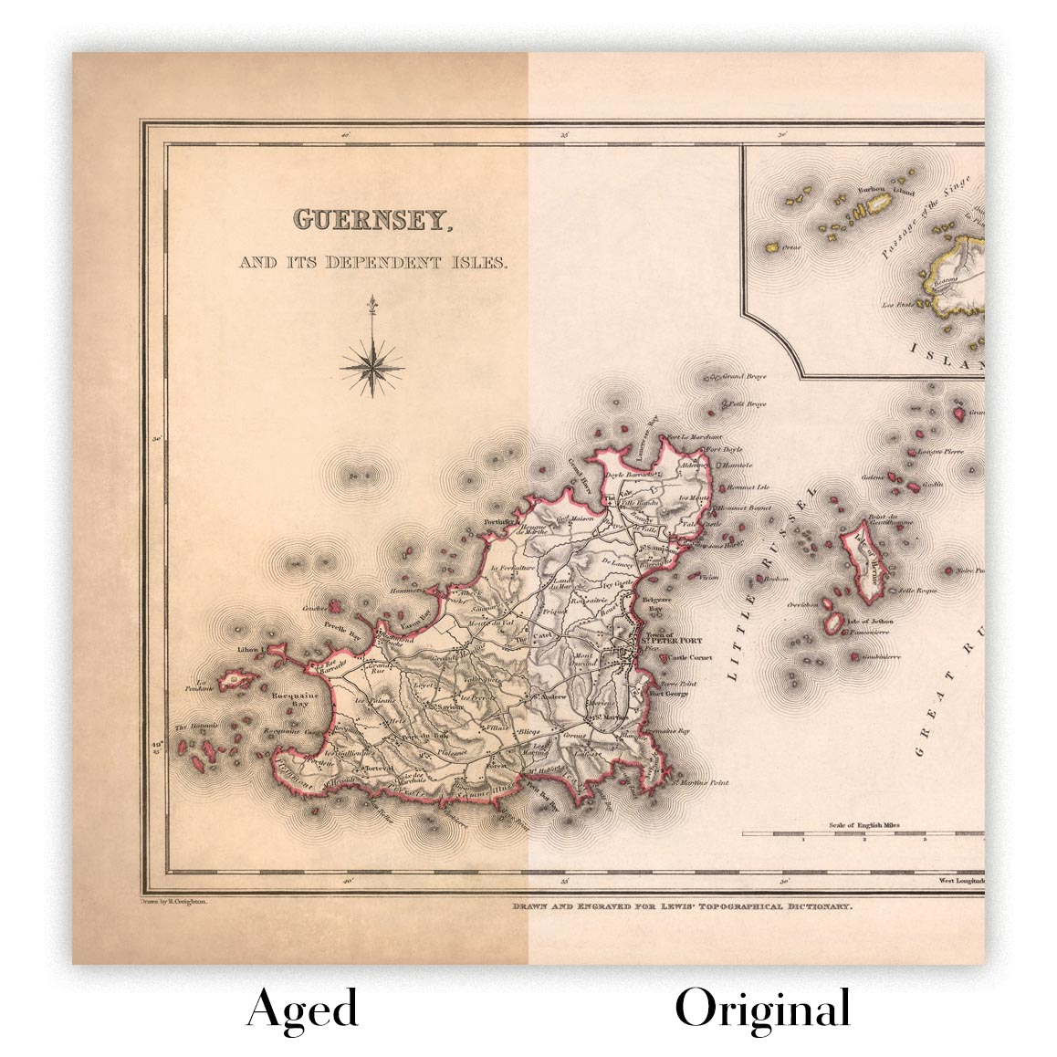
Map ageing
I have been asked hundreds of times over the years by customers if they could buy a map that looks even older.
Well, now you can, by selecting Aged before you add a map to your basket.
All the product photos you see on this page show the map in its Original form. This is what the map looks like today.
If you select Aged, I will age your map by hand, using a special and unique process developed through years of studying old maps, talking to researchers to understand the chemistry of aging paper, and of course... lots of practice!
If you're unsure, stick to the Original colour of the map. If you want something a bit darker and older looking, go for Aged.
If you are not happy with your order for any reason, contact me and I'll get it fixed ASAP, free of charge. Please see my returns and refund policy for more information.
I am very confident you will like your restored map or art print. I have been doing this since 1984. I'm a 5-star Etsy seller. I have sold tens of thousands of maps and art prints and have over 5,000 real 5-star reviews. My work has been featured in interior design magazines, on the BBC, and on the walls of dozens of 5-star hotels.
I use a unique process to restore maps and artwork that is massively time consuming and labour intensive. Hunting down the original maps and illustrations can take months. I use state of the art and eye-wateringly expensive technology to scan and restore them. As a result, I guarantee my maps and art prints are a cut above the rest. I stand by my products and will always make sure you're 100% happy with what you receive.
Almost all of my maps and art prints look amazing at large sizes (200cm, 6.5ft+) and I can frame and deliver them to you as well, via special oversized courier. Contact me to discuss your specific needs.
Or try searching for something!


