

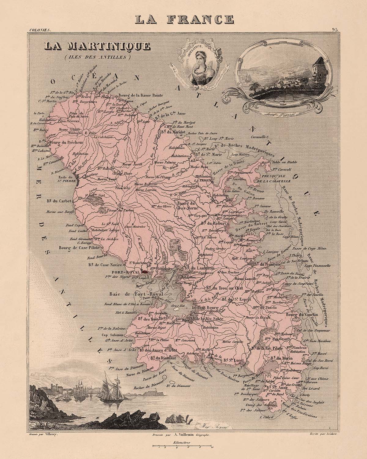


Old Map of Martinique, Lesser Antilles by Vuillemin, 1869: Fort-de-France, Saint-Pierre, Sugar Cane
20% off 2 — 33% off 3
Add any two eligible items to your bag to receive 20% off. Add a third and it will be complimentary (equivalent to 33% off when purchasing three).
No code needed — the offer applies automatically at checkout.
Valid on all standard maps and fine art prints. You can mix and match any designs.
If you’d like to ship items to multiple addresses, please contact us before placing your order.
Custom and bespoke commissions are excluded.
Contact us if you have any questions
-
![]() Handmade in the UK (we're based in London)
Handmade in the UK (we're based in London)

-
FREE worldwide delivery in 2-3 days ⓘ
Free delivery in 2-3 days
Your map should be delivered in 2-3 working days with free delivery, worldwide.
Mother's Day: Order by 9th March with free delivery, or 11th March with express delivery.
We make maps by hand locally in 23 countries, including the UK
![]() . If you're buying a gift for someone in another country, we will make the map locally to them.
. If you're buying a gift for someone in another country, we will make the map locally to them.You will never pay import tax or customs duty.
Express delivery is available at checkout which can reduce the delivery time to 1-2 days.
Please note that personalised maps, and larger framed maps, can take longer to produce and deliver.
If you need your order to arrive by a certain date, contact me and we can discuss your options.
-
Complimentary gifting & design advice
ⓘ
Complimentary gifting & design advice
Available almost 24/7 on WhatsApp and email — we usually reply within minutes. We can help you:
- Choose a perfectly personalised gift
- Send a digital gift preview to the recipient
- Pick the ideal size for your wall
- Select the right finish and frame
Quick, friendly advice so you can order with confidence.
For last minute gifts, consider buying a digital gift card. We have over 5,000 maps and art prints to choose from.
-
90-day returns & 5-year guarantee
ⓘ
90-day returns & 5-year guarantee
Products can be returned within 90 days for a full refund, or exchange for another product.
We are also proud to offer a 5-year quality guarantee on our maps and art, covering defects in materials or workmanship under normal use.
For personalised and custom made items, we may offer you store credit or a non-expiring gift card, as we cannot resell personalised orders.
If you have any questions, get in touch. For more information, see our full returns & exchanges policy.

This is a museum-grade archival print from the original 1869 map — restored in our workshop and made to order on 220gsm archival matte paper or 400gsm artist's cotton canvas with pigment inks.
Professional framing & free personalisation available.
1. Choose a size
2. Frame & personalise your map
Make your map unique with framing, hand-drawn customisation, vintage ageing, pop art text, unique 3D styling and more.


Gift message & custom finish

If you want to add a gift message, or a finish (jigsaw, aluminium board, etc.) that is not available here, please request it in the "order note" when you check out.
Every order is custom made, so if you need the size adjusted slightly, or printed on an unusual material, just let us know. We've done thousands of custom orders over the years, so there's (almost) nothing we can't manage.
You can also contact us before you order, if you prefer!

- Handmade locally. No import duty or tax
- FREE worldwide delivery
- 90-day returns & 5-year product guarantee
- Questions? WhatsApp me any time
Own a piece of history
7,000+ 5 star reviews


Step into the vibrant world of 19th-century Caribbean cartography with “La Martinique,” an exquisitely detailed map crafted by the renowned French cartographer A. Vuillemin in 1869. Bearing its original French title, this map stands as a testament to both artistic finesse and geographic precision, capturing the island of Martinique in a period of profound historical significance. Vuillemin’s meticulous approach is evident in the harmonious blend of vivid color, intricate border vignettes, and precise political boundaries, offering a window into the colonial era when Martinique was a prized overseas department of France.
A. Vuillemin, celebrated for his skill in combining decorative artistry with scientific accuracy, infused this map with a wealth of visual and contextual detail. Around the central depiction of Martinique, the map is adorned with vignettes that illustrate the island’s unique culture and natural wealth. Scenes of local life—farming, fishing, and maritime trade—intermingle with images of indigenous wildlife and agricultural abundance, notably the flourishing sugar cane fields that once fueled the island’s economy. These artistic flourishes are not mere embellishments; they are thoughtfully chosen to reflect the social and economic lifeblood of Martinique in the late 1800s.
The map’s design is a masterclass in both cartographic clarity and decorative elegance. Vuillemin’s use of color delineates the island’s administrative divisions, while the decorative coat of arms and maritime scenes underscore Martinique’s strategic importance as a French colonial outpost. The mountainous terrain, lush coastal regions, and detailed hydrography evoke the dramatic natural beauty of the island, from its volcanic peaks to its verdant valleys and sparkling shores. The map’s composition invites the viewer to explore not just geography, but the lived experience of Martinique’s inhabitants.
Beyond its visual splendor, “La Martinique” is enriched with contextual notes and statistical information, originally paired with descriptive text that situated the island within the broader French colonial world. The map includes data on distances and directions from Paris, reinforcing Martinique’s role as a far-flung yet integral part of the French empire. This contextual layering transforms the map from a simple navigational aid into a comprehensive portrait of a society—its people, its products, and its place in the world.
The map’s careful labeling of towns and settlements—such as Fort-de-France, Saint-Pierre, Le Marin, and La Trinité—offers a rare glimpse into the urban and rural landscape of Martinique during a pivotal era. Each settlement is rendered with a clarity that speaks to Vuillemin’s commitment to accuracy, while the surrounding illustrations breathe life into the historical and cultural context of each locale. Whether you are drawn to the artistry of antique maps, the allure of Caribbean history, or the legacy of French cartography, “La Martinique” by A. Vuillemin is a truly captivating artifact, offering both aesthetic delight and a deep well of historical insight.
Cities and towns on this map
- Fort-de-France
- Saint-Pierre
- Le Marin
- La Trinité
- Le François
- Sainte-Marie
- Le Robert
- Le Carbet
- Le Lamentin
- Rivière-Pilote
- Saint-Esprit
- Case-Pilote
- Sainte-Anne
- Le Vauclin
- Macouba
- Le Morne-Rouge
- Le Morne-Vert
- Le Gros-Morne
- Les Trois-Îlets
- Basse-Pointe
- Ducos
- Fonds-Saint-Denis
- Grand'Rivière
- Rivière-Salée
- Ajoupa-Bouillon
- Bellefontaine
- Schoelcher
- Le Diamant
Notable Features & Landmarks
- Illustrations of agricultural crops, notably sugar cane, highlighting the island's historical economic reliance on sugar production
- Depiction of local wildlife, including birds and marine life, emphasizing the biodiversity of Martinique
- Scenes of local human activities, such as farming and fishing, providing a glimpse into daily life and economic practices
- A decorative coat of arms representing Martinique
- Illustrations of sailing ships, reflecting the maritime importance and trade connections of the island
- Scenes depicting the natural landscape, including mountainous terrain and coastal features
Historical and design context
- Original title: La Martinique
- Created by renowned French cartographer A. Vuillemin in 1869
- The map is intricately designed and colored, featuring decorative vignettes around the borders
- Part of a collection pairing each map with descriptive text, offering comprehensive overviews of the depicted department or colony
- Includes statistical data and contextual information such as distance and direction from Paris
- Reflects the colonial perspective of the 19th century, showcasing the economic and cultural importance of Martinique to France
- Provides insights into historical agricultural practices and local culture during the colonial era
- Harmonious blend of vivid color, intricate border vignettes, and precise political boundaries
Please double check the images to make sure that a specific town or place is shown on this map. You can also get in touch and ask us to check the map for you.
This map looks great at every size, but I always recommend going for a larger size if you have space. That way you can easily make out all of the details.
This map looks amazing at sizes all the way up to 50in (125cm). If you are looking for a larger map, please get in touch.
The model in the listing images is holding the 16x20in (40x50cm) version of this map.
The fifth listing image shows an example of my map personalisation service.
If you’re looking for something slightly different, check out my collection of the best old maps to see if something else catches your eye.
Please contact me to check if a certain location, landmark or feature is shown on this map.
This would make a wonderful birthday, Christmas, Father's Day, work leaving, anniversary or housewarming gift for someone from the areas covered by this map.
This map is available as a giclée print on acid free archival matte paper, or you can buy it framed. The frame is a nice, simple black frame that suits most aesthetics. Please get in touch if you'd like a different frame colour or material. My frames are glazed with super-clear museum-grade acrylic (perspex/acrylite), which is significantly less reflective than glass, safer, and will always arrive in perfect condition.
This map is also available as a float framed canvas, sometimes known as a shadow gap framed canvas or canvas floater. The map is printed on artist's cotton canvas and then stretched over a handmade box frame. We then "float" the canvas inside a wooden frame, which is available in a range of colours (black, dark brown, oak, antique gold and white). This is a wonderful way to present a map without glazing in front. See some examples of float framed canvas maps and explore the differences between my different finishes.
For something truly unique, this map is also available in "Unique 3D", our trademarked process that dramatically transforms the map so that it has a wonderful sense of depth. We combine the original map with detailed topography and elevation data, so that mountains and the terrain really "pop". For more info and examples of 3D maps, check my Unique 3D page.
For most orders, delivery time is about 3 working days. Personalised and customised products take longer, as I have to do the personalisation and send it to you for approval, which usually takes 1 or 2 days.
Please note that very large framed orders usually take longer to make and deliver.
If you need your order to arrive by a certain date, please contact me before you order so that we can find the best way of making sure you get your order in time.
I print and frame maps and artwork in 23 countries around the world. This means your order will be made locally, which cuts down on delivery time and ensures that it won't be damaged during delivery. You'll never pay customs or import duty, and we'll put less CO2 into the air.
All of my maps and art prints are well packaged and sent in a rugged tube if unframed, or surrounded by foam if framed.
I try to send out all orders within 1 or 2 days of receiving your order, though some products (like face masks, mugs and tote bags) can take longer to make.
If you select Express Delivery at checkout your order we will prioritise your order and send it out by 1-day courier (Fedex, DHL, UPS, Parcelforce).
Next Day delivery is also available in some countries (US, UK, Singapore, UAE) but please try to order early in the day so that we can get it sent out on time.
My standard frame is a gallery style black ash hardwood frame. It is simple and quite modern looking. My standard frame is around 20mm (0.8in) wide.
I use super-clear acrylic (perspex/acrylite) for the frame glass. It's lighter and safer than glass - and it looks better, as the reflectivity is lower.
Six standard frame colours are available for free (black, dark brown, dark grey, oak, white and antique gold). Custom framing and mounting/matting is available if you're looking for something else.
Most maps, art and illustrations are also available as a framed canvas. We use matte (not shiny) cotton canvas, stretch it over a sustainably sourced box wood frame, and then 'float' the piece within a wood frame. The end result is quite beautiful, and there's no glazing to get in the way.
All frames are provided "ready to hang", with either a string or brackets on the back. Very large frames will have heavy duty hanging plates and/or a mounting baton. If you have any questions, please get in touch.
See some examples of my framed maps and framed canvas maps.
Alternatively, I can also supply old maps and artwork on canvas, foam board, cotton rag and other materials.
If you want to frame your map or artwork yourself, please read my size guide first.
My maps are extremely high quality reproductions of original maps.
I source original, rare maps from libraries, auction houses and private collections around the world, restore them at my London workshop, and then use specialist giclée inks and printers to create beautiful maps that look even better than the original.
My maps are printed on acid-free archival matte (not glossy) paper that feels very high quality and almost like card. In technical terms the paper weight/thickness is 10mil/200gsm. It's perfect for framing.
I print with Epson ultrachrome giclée UV fade resistant pigment inks - some of the best inks you can find.
I can also make maps on canvas, cotton rag and other exotic materials.
Learn more about The Unique Maps Co.
Map personalisation
If you're looking for the perfect anniversary or housewarming gift, I can personalise your map to make it truly unique. For example, I can add a short message, or highlight an important location, or add your family's coat of arms.
The options are almost infinite. Please see my map personalisation page for some wonderful examples of what's possible.
To order a personalised map, select "personalise your map" before adding it to your basket.
Get in touch if you're looking for more complex customisations and personalisations.
Map ageing
I have been asked hundreds of times over the years by customers if they could buy a map that looks even older.
Well, now you can, by selecting Aged before you add a map to your basket.
All the product photos you see on this page show the map in its Original form. This is what the map looks like today.
If you select Aged, I will age your map by hand, using a special and unique process developed through years of studying old maps, talking to researchers to understand the chemistry of aging paper, and of course... lots of practice!
If you're unsure, stick to the Original colour of the map. If you want something a bit darker and older looking, go for Aged.
If you are not happy with your order for any reason, contact me and I'll get it fixed ASAP, free of charge. Please see my returns and refund policy for more information.
I am very confident you will like your restored map or art print. I have been doing this since 1984. I'm a 5-star Etsy seller. I have sold tens of thousands of maps and art prints and have over 5,000 real 5-star reviews. My work has been featured in interior design magazines, on the BBC, and on the walls of dozens of 5-star hotels.
I use a unique process to restore maps and artwork that is massively time consuming and labour intensive. Hunting down the original maps and illustrations can take months. I use state of the art and eye-wateringly expensive technology to scan and restore them. As a result, I guarantee my maps and art prints are a cut above the rest. I stand by my products and will always make sure you're 100% happy with what you receive.
Almost all of my maps and art prints look amazing at large sizes (200cm, 6.5ft+) and I can frame and deliver them to you as well, via special oversized courier. Contact me to discuss your specific needs.
Or try searching for something!


