


Old Map of "French India" by Vuillemin, 1869: French Enclaves, Pondicherry, Chandannagar, Mahé, Bay of Bengal
Buy 2, Get 1 Free
If you add 2 items to your bag, you can add a third product for free. The discount is automatic - no code required.
This is equivalent to 33% off, which will be the largest discount available on my shop this year.
This works for all maps and artwork. You can order 3 of the same thing, or 3 different things.
My custom maps are excluded, as they're too time consuming to make and we'd prefer to take our time rather than rush through a lot of orders.
Please take advantage of the deal and buy lots of beautiful maps and art for your walls.
Contact me if you have any questions.

-
![]() Handmade in the UK (we're based in London)
Handmade in the UK (we're based in London)
-
FREE worldwide delivery in 2-3 days ⓘ
Free delivery in 2-3 days
Your map should be delivered in 2-3 working days with free delivery, worldwide.
Deliveries over the Christmas and New Year period may be slightly delayed, as couriers and postal services catch up with a huge backlog of packages.
We make maps by hand locally in 23 countries, including the UK
![]() . If you're buying a gift for someone in another country, we will make the map locally to them.
. If you're buying a gift for someone in another country, we will make the map locally to them.You will never pay import tax or customs duty.
Express delivery is available at checkout which can reduce the delivery time to 1-2 days.
Please note that personalised maps, and larger framed maps, can take longer to produce and deliver.
If you need your order to arrive by a certain date, contact me and we can discuss your options.
-
FREE gift preview
ⓘ
Digital gift preview
After you complete your order, you can send a beautiful digital preview to the gift recipient. Just provide their email address and we'll do the rest. (Their email address will not be stored or used for any other purpose.)
This is perfect if you're concerned that your order might not arrive in time.
You can also buy a real non-expiring gift card, and email it directly to the recipient, so they can buy their own map or artwork.
-
90 day money back guarantee
ⓘ
90 days to return and refund
Products can be returned within 90 days for a full refund, or exchange for another product.
For personalised and custom made items, we may offer you store credit or a non-expiring gift card, as we cannot resell personalised orders.
If you have any questions, get in touch. For more information, see our full returns & exchanges policy.

My maps are rare, museum-grade, restored old maps sourced from libraries, auction houses and private collections across the globe.
Framing & free personalisation available
1. Select your size
Click here to order a custom size.
2. Frame & personalise your map
Make your map unique with framing, hand-drawn customisation, vintage ageing, pop art text, unique 3D styling and more.


Gift message & custom finish

If you want to add a gift message, or a finish (jigsaw, aluminium board, etc.) that is not available here, please request it in the "order note" when you check out.
Every order is custom made, so if you need the size adjusted slightly, or printed on an unusual material, just let us know. We've done thousands of custom orders over the years, so there's (almost) nothing we can't manage.
You can also contact us before you order, if you prefer!

- Handmade locally. No import duty or tax
- FREE worldwide delivery
- Love it or your money back (90 days)
- Questions? WhatsApp me any time
Own a piece of history
5,000+ 5 star reviews


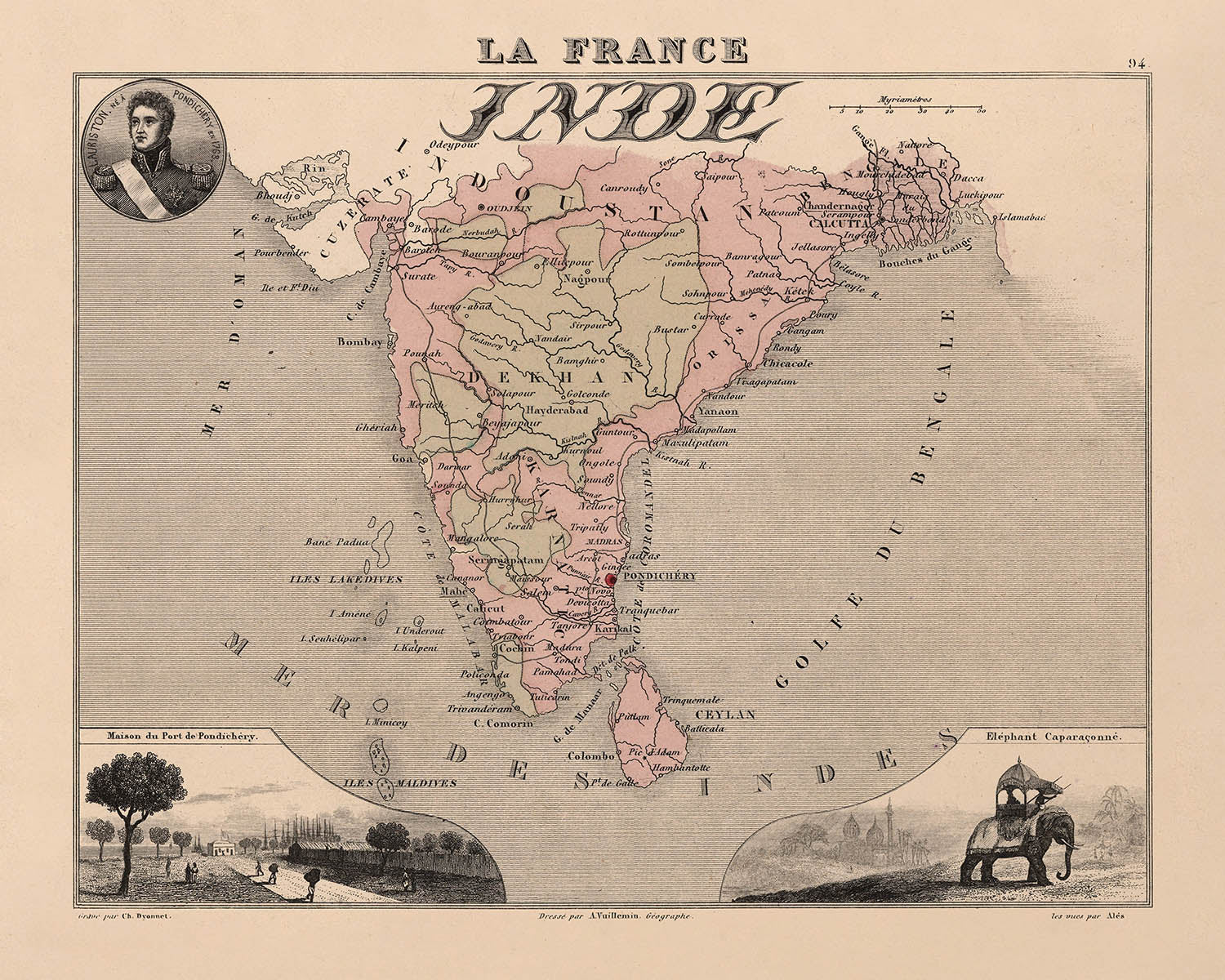
Step into the vivid world of 19th-century colonial cartography with "French India," originally titled Inde la France, created by the esteemed French mapmaker A. Vuillemin in 1869. This map stands as a testament to the artistic and scholarly ambitions of its era, blending precise geographical detail with evocative vignettes that bring to life the cultural and economic tapestry of French colonial enclaves in India. Vuillemin’s meticulous approach is evident in every element, from the clear delineation of French territories to the vibrant illustrations that frame the map, offering viewers a window into the landscapes and daily rhythms of a distant colonial world.
A. Vuillemin was renowned for his ability to merge scientific cartography with artistic flourish, and this map is a quintessential example of his craft. Each region—Pondichéry, Karikal, Mahé, Yanaon, and Chandernagor—is carefully rendered, with boundaries crisply defined to highlight the French presence amid the vast British-controlled Indian subcontinent. Vuillemin’s work is further distinguished by the inclusion of local scenes, notable personages, and coats-of-arms, all meticulously illustrated to evoke the unique identity of each enclave. His attention to detail not only enhances the map’s aesthetic appeal but also serves as a valuable historical record of a bygone era.
The map’s artistry is complemented by its rich thematic content. Surrounding the main cartographic panels are vignettes depicting the people, crops, and activities that characterized French India in the 19th century. These illustrations are more than mere decoration—they are windows into the social and economic life of the region, from bustling marketplaces to serene riversides. The map also features informative text, providing statistics and geographical context, including the distance and direction from Paris, thus situating these distant colonies within the broader narrative of French imperial ambition.
Geographically, the map is a masterclass in precision and clarity. Major bodies of water such as the Bay of Bengal, Arabian Sea, and Indian Ocean are rendered with care, while rivers like the Hooghly near Chandernagor add depth and realism to the composition. The coastal outlines and river courses are not only accurate but also elegantly integrated into the map’s overall design. The borders of the French territories are clearly marked, offering a striking contrast to the surrounding regions and underscoring the geopolitical complexities of colonial India.
Perhaps most compelling are the cities and towns that anchor this map—Puducherry (Pondichéry), Karaikal, Chandannagar, Yanam, and Mahé. Each settlement is marked with historical precision, reflecting its importance as a center of administration, trade, and cultural exchange. These enclaves, though small in size, played an outsized role in the story of French India, serving as gateways for commerce and cross-cultural interaction. Through Vuillemin’s expert hand, these places come alive, inviting the viewer to explore not just the geography, but the living history of a unique chapter in the colonial encounter between France and India.
Cities and towns on this map
- Puducherry (Pondichéry)
- Karaikal (Karikal)
- Chandannagar (Chandernagor)
- Yanam (Yanaon)
- Mahé
Notable Features & Landmarks
- Map showing the individual French enclaves in India, including Pondichéry, Karikal, Mahé, Yanaon, and Chandernagor
- Artistic vignettes depicting local scenes, cultural practices, and human activities relevant to the French Indian territories
- Depictions of local people in traditional attire, engaged in daily activities
- Bay of Bengal
- Arabian Sea
- Indian Ocean
- Rivers clearly depicted near the enclaves, such as the Hooghly River near Chandernagor
- Clearly delineated borders of French territories, distinguishing them from surrounding British-controlled areas
- Prominent coastal outlines and river courses
Historical and design context
- Created by A. Vuillemin, a renowned 19th-century French cartographer known for combining scientific cartography with artistic flourish
- Produced in 1869, reflecting the extent and nature of French colonial influence in India during the late 19th century
- Part of a collection characterized by colorful artistic maps paired with vignettes illustrating local scenes, notable figures, animals, human activities, crops, and coats-of-arms
- Each map in the collection is accompanied by comprehensive textual information, including statistics and geographical details such as distances and directions from Paris
- Artistic and decorative style typical of 19th-century European cartography, blending geographical accuracy with cultural and historical context
- Provides insight into European colonialism, trade, and cultural interactions between France and India at the time
Please double check the images to make sure that a specific town or place is shown on this map. You can also get in touch and ask us to check the map for you.
This map looks great at every size, but I always recommend going for a larger size if you have space. That way you can easily make out all of the details.
This map looks amazing at sizes all the way up to 50in (125cm). If you are looking for a larger map, please get in touch.
The model in the listing images is holding the 16x20in (40x50cm) version of this map.
The fifth listing image shows an example of my map personalisation service.
If you’re looking for something slightly different, check out my collection of the best old maps to see if something else catches your eye.
Please contact me to check if a certain location, landmark or feature is shown on this map.
This would make a wonderful birthday, Christmas, Father's Day, work leaving, anniversary or housewarming gift for someone from the areas covered by this map.
This map is available as a giclée print on acid free archival matte paper, or you can buy it framed. The frame is a nice, simple black frame that suits most aesthetics. Please get in touch if you'd like a different frame colour or material. My frames are glazed with super-clear museum-grade acrylic (perspex/acrylite), which is significantly less reflective than glass, safer, and will always arrive in perfect condition.
This map is also available as a float framed canvas, sometimes known as a shadow gap framed canvas or canvas floater. The map is printed on artist's cotton canvas and then stretched over a handmade box frame. We then "float" the canvas inside a wooden frame, which is available in a range of colours (black, dark brown, oak, antique gold and white). This is a wonderful way to present a map without glazing in front. See some examples of float framed canvas maps and explore the differences between my different finishes.
For something truly unique, this map is also available in "Unique 3D", our trademarked process that dramatically transforms the map so that it has a wonderful sense of depth. We combine the original map with detailed topography and elevation data, so that mountains and the terrain really "pop". For more info and examples of 3D maps, check my Unique 3D page.
For most orders, delivery time is about 3 working days. Personalised and customised products take longer, as I have to do the personalisation and send it to you for approval, which usually takes 1 or 2 days.
Please note that very large framed orders usually take longer to make and deliver.
If you need your order to arrive by a certain date, please contact me before you order so that we can find the best way of making sure you get your order in time.
I print and frame maps and artwork in 23 countries around the world. This means your order will be made locally, which cuts down on delivery time and ensures that it won't be damaged during delivery. You'll never pay customs or import duty, and we'll put less CO2 into the air.
All of my maps and art prints are well packaged and sent in a rugged tube if unframed, or surrounded by foam if framed.
I try to send out all orders within 1 or 2 days of receiving your order, though some products (like face masks, mugs and tote bags) can take longer to make.
If you select Express Delivery at checkout your order we will prioritise your order and send it out by 1-day courier (Fedex, DHL, UPS, Parcelforce).
Next Day delivery is also available in some countries (US, UK, Singapore, UAE) but please try to order early in the day so that we can get it sent out on time.
My standard frame is a gallery style black ash hardwood frame. It is simple and quite modern looking. My standard frame is around 20mm (0.8in) wide.
I use super-clear acrylic (perspex/acrylite) for the frame glass. It's lighter and safer than glass - and it looks better, as the reflectivity is lower.
Six standard frame colours are available for free (black, dark brown, dark grey, oak, white and antique gold). Custom framing and mounting/matting is available if you're looking for something else.
Most maps, art and illustrations are also available as a framed canvas. We use matte (not shiny) cotton canvas, stretch it over a sustainably sourced box wood frame, and then 'float' the piece within a wood frame. The end result is quite beautiful, and there's no glazing to get in the way.
All frames are provided "ready to hang", with either a string or brackets on the back. Very large frames will have heavy duty hanging plates and/or a mounting baton. If you have any questions, please get in touch.
See some examples of my framed maps and framed canvas maps.
Alternatively, I can also supply old maps and artwork on canvas, foam board, cotton rag and other materials.
If you want to frame your map or artwork yourself, please read my size guide first.
My maps are extremely high quality reproductions of original maps.
I source original, rare maps from libraries, auction houses and private collections around the world, restore them at my London workshop, and then use specialist giclée inks and printers to create beautiful maps that look even better than the original.
My maps are printed on acid-free archival matte (not glossy) paper that feels very high quality and almost like card. In technical terms the paper weight/thickness is 10mil/200gsm. It's perfect for framing.
I print with Epson ultrachrome giclée UV fade resistant pigment inks - some of the best inks you can find.
I can also make maps on canvas, cotton rag and other exotic materials.
Learn more about The Unique Maps Co.
Map personalisation
If you're looking for the perfect anniversary or housewarming gift, I can personalise your map to make it truly unique. For example, I can add a short message, or highlight an important location, or add your family's coat of arms.
The options are almost infinite. Please see my map personalisation page for some wonderful examples of what's possible.
To order a personalised map, select "personalise your map" before adding it to your basket.
Get in touch if you're looking for more complex customisations and personalisations.
Map ageing
I have been asked hundreds of times over the years by customers if they could buy a map that looks even older.
Well, now you can, by selecting Aged before you add a map to your basket.
All the product photos you see on this page show the map in its Original form. This is what the map looks like today.
If you select Aged, I will age your map by hand, using a special and unique process developed through years of studying old maps, talking to researchers to understand the chemistry of aging paper, and of course... lots of practice!
If you're unsure, stick to the Original colour of the map. If you want something a bit darker and older looking, go for Aged.
If you are not happy with your order for any reason, contact me and I'll get it fixed ASAP, free of charge. Please see my returns and refund policy for more information.
I am very confident you will like your restored map or art print. I have been doing this since 1984. I'm a 5-star Etsy seller. I have sold tens of thousands of maps and art prints and have over 5,000 real 5-star reviews. My work has been featured in interior design magazines, on the BBC, and on the walls of dozens of 5-star hotels.
I use a unique process to restore maps and artwork that is massively time consuming and labour intensive. Hunting down the original maps and illustrations can take months. I use state of the art and eye-wateringly expensive technology to scan and restore them. As a result, I guarantee my maps and art prints are a cut above the rest. I stand by my products and will always make sure you're 100% happy with what you receive.
Almost all of my maps and art prints look amazing at large sizes (200cm, 6.5ft+) and I can frame and deliver them to you as well, via special oversized courier. Contact me to discuss your specific needs.
Or try searching for something!


