

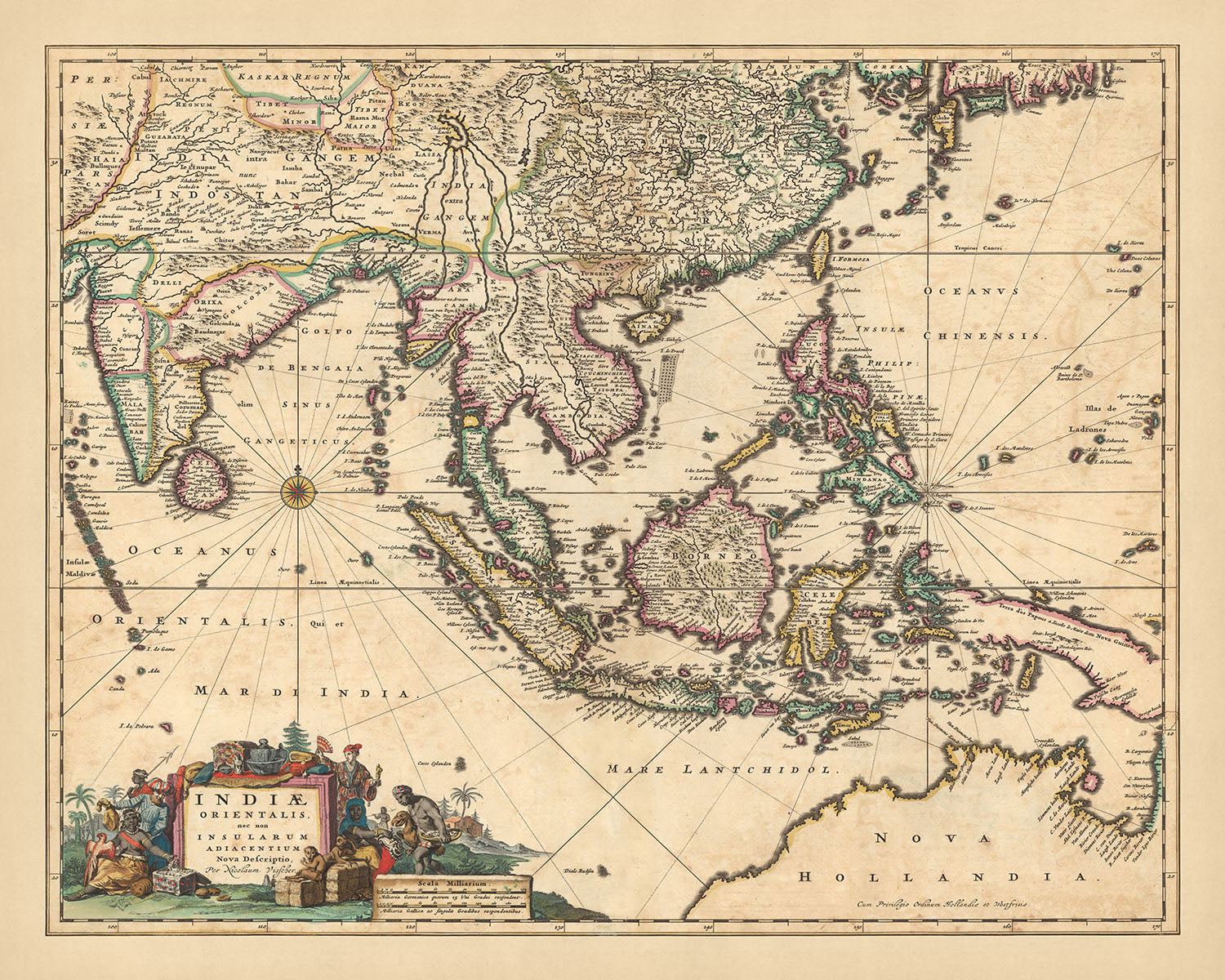

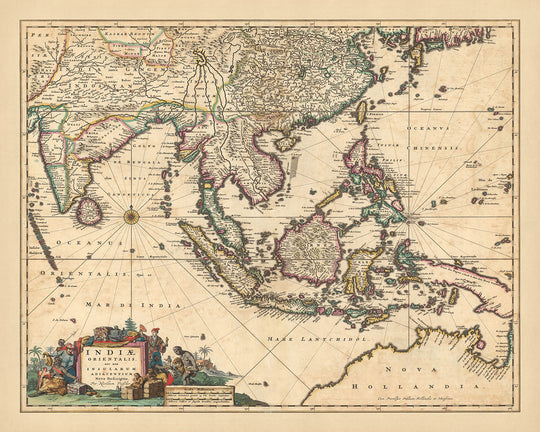


Old Map of the East Indies by Visscher, 1690: Southeast Asia, South Asia, Southern China, Northern Territory, Himalayas

-
![]() Handmade in the UK (we're based in London)
Handmade in the UK (we're based in London)
-
FREE worldwide delivery in 2-3 days ⓘ
Free delivery in 2-3 days
Your map should be delivered in 2-3 working days with free delivery, worldwide.
We make maps by hand locally in 23 countries, including the UK
![]() . If you're buying a gift for someone in another country, we will make the map locally to them.
. If you're buying a gift for someone in another country, we will make the map locally to them.You will never pay import tax or customs duty.
Express delivery is available at checkout which can reduce the delivery time to 1-2 days.
Please note that personalised maps, and larger framed maps, can take longer to produce and deliver.
If you need your order to arrive by a certain date, contact me and we can discuss your options.
-
90 day money back guarantee
ⓘ
90 days to return and refund
Products can be returned within 90 days for a full refund, or exchange for another product.
For personalised or custom made items, we may offer you store credit or a non-expiring gift card, as we cannot resell personalised orders.
If you have any questions, get in touch. For more information, see our full returns & exchanges policy.

My maps are rare, museum-grade, restored old maps sourced from libraries, auction houses and private collections across the globe.
Framing & free personalisation available
1. Select your size
2. Frame & personalise your map
Make your map unique with framing, hand-drawn customisation, vintage ageing, pop art text, unique 3D styling and moreGift message & custom finish

If you want to add a gift message, or a finish (jigsaw, aluminium board, etc.) that is not available here, please request it in the "order note" when you check out.
Every order is custom made, so if you need the size adjusted slightly, or printed on an unusual material, just let us know. We've done thousands of custom orders over the years, so there's (almost) nothing we can't manage.
You can also contact us before you order, if you prefer!

- Handmade locally. No import duty or tax
- FREE Delivery. Arrives in 2-3 days
- Love it or your money back
- Questions? WhatsApp me any time
Own a piece of history
5,000+ 5 star reviews


Immerse yourself in the rich tapestry of history with our exquisite map, 'Indiae Orientalis nec non Insularum Adiacentium Nova Descriptio', or in English, 'New Description of the East Indies and Adjacent Islands'. This captivating piece was crafted by Nicolaes Visscher II in 1690, a renowned mapmaker from the Dutch Golden Age, carrying forward the legacy of his grandfather, Claes Janszoon Visscher. This map, with its meticulous detailing and artistry, offers a fascinating glimpse into the geopolitical landscape of the larger modern day area of Asia during the late 17th century.
The map is a detailed representation of Southeast Asia, South Asia, Southern China, Northern Territory, and the Himalayas. It beautifully illustrates the political and administrative boundaries of the time, along with prominent cities and towns. The waterways, canals, and landmarks are painstakingly depicted, giving a comprehensive view of the region's geographical features. The decorative cartouche and compass rose add an artistic touch to the overall aesthetics of the map.
A closer look at the map reveals the intricate hand-colored outline engravings. The relief is shown pictorially, which brings a sense of depth and realism to the map. The lakes and mountains are not just geographical features, but also a testament to the mapmaker's skill and attention to detail. The map is not just a geographical representation, but also a work of art that reflects the cartographic excellence of the Dutch Golden Age.
This map is not just a piece of history, but also a conversation starter. It is a testament to the time when the East Indies and its adjacent islands were a hub of trade and exploration. The map, with its depiction of the then known world, invites the viewer to delve into the past and explore the world as it was known in the 17th century. This map is more than a decorative piece, it is a journey into the past, a testament to human curiosity and the desire to explore and understand our world.
Some of the significant locations shown on this map:
Southeast Asia - Jakarta (Historically known as Sunda Kelapa, Jayakarta, and Batavia): The capital of Indonesia, notable for its historical importance as a major trading port. - Manila (Historically known as Maynila): The capital of the Philippines, known for its strategic location and rich cultural heritage. - Hanoi (Historically known as Thăng Long, Đông Kinh): The capital of Vietnam, known for its centuries-old architecture. - Ho Chi Minh City (Historically known as Prey Nokor, Gia Định, and Saigon): The most populous city in Vietnam, notable for its French colonial landmarks. - Bangkok (Historically known as Bang Makok): The capital of Thailand, known for its vibrant street life and cultural landmarks.
South Asia - Delhi (Historically known as Shahjahanabad): The capital of India, known for its rich history and architectural wonders. - Lahore (Historically known as Lavapuri): The second largest city in Pakistan, known for its Mughal Era monuments. - Dhaka (Historically known as Jahangir Nagar): The capital of Bangladesh, known for its vibrant culture and history. - Colombo (Historically known as Kolon Thota): The commercial capital of Sri Lanka, known for its colonial architecture. - Kathmandu (Historically known as Kantipur): The capital of Nepal, known for its multiethnic population and rich culture.
Southern China - Beijing (Historically known as Yanjing, Dadu, and Beiping): The capital of China, known for its opulent palaces, temples, and huge stone walls. - Shanghai (Historically known as Hu): The most populous city in China, known for its skyline and historical landmarks. - Guangzhou (Historically known as Canton): Known for its avant-garde architecture and bustling markets. - Hangzhou (Historically known as Lin'an): Known for its beautiful natural scenery and historical heritage. - Nanjing (Historically known as Yingtian, Jiankang): Known for its significant place in Chinese history and culture.
Northern Territory - Darwin: The capital of Australia's Northern Territory, known for its Aboriginal art and natural beauty.
Himalayas - Lhasa (Historically known as Rasa): The capital of Tibet, known for its religious significance and historical sites. - Kathmandu (Historically known as Kantipur): The capital of Nepal, known for its temples and historical sites. - Thimphu: The capital of Bhutan, known for its monasteries and fortresses. - Dehradun (Historically known as Sudhnagar): The capital of Uttarakhand, India, known for its natural beauty and educational institutions. - Shimla (Historically known as Shyamala): The capital of Himachal Pradesh, India, known for its colonial architecture and Himalayan views.
Notable natural phenomena and tourist attractions: - The Great Wall of China: A historical fortification in Northern China. - The Yellow River: The second longest river in China, often referred to as the "Cradle of Chinese Civilization". - Mount Everest: The highest peak in the world, located in the Himalayas. - Halong Bay: A beautiful natural wonder in northern Vietnam with emerald waters and thousands of towering limestone islands. - Angkor Wat: The largest religious monument in the world, located in Cambodia.
Historical events between 1600 and 1690: - The construction of Taj Mahal in Agra, India (1632 - 1653): An ivory-white marble mausoleum built by the Mughal emperor Shah Jahan for his wife Mumtaz Mahal. - The Manchu conquest of China (1618 - 1683): A period of conflict in which the Manchu people, led by the Qing dynasty, conquered the Ming dynasty of China. - The Siege of Malacca (1606): A successful Portuguese defense against Dutch attempts to capture Malacca.
Please double check the images to make sure that a specific town or place is shown on this map. You can also get in touch and ask us to check the map for you.
This map looks great at all sizes: 12x16in (30.5x41cm), 16x20in (40.5x51cm), 18x24in (45.5x61cm), 24x30in (61x76cm), 32x40in (81.5x102cm), 40x50in (102x127cm), 48x60in (122x153cm) and 56x70in (142x178cm), but it looks even better when printed large.
I can create beautiful, large prints of this map up to 90in (229cm). Please get in touch if you're looking for larger, customised or different framing options.
The model in the listing images is holding the 16x20in (40.5x51cm) version of this map.
The fifth listing image shows an example of my map personalisation service.
If you’re looking for something slightly different, check out my collection of the best old maps of Europe and European cities to see if something else catches your eye.
Please contact me to check if a certain location, landmark or feature is shown on this map.
This would make a wonderful birthday, Christmas, Father's Day, work leaving, anniversary or housewarming gift for someone from the areas covered by this map.
This map is available as a giclée print on acid free archival matte paper, or you can buy it framed. The frame is a nice, simple black frame that suits most aesthetics. Please get in touch if you'd like a different frame colour or material. My frames are glazed with super-clear museum-grade acrylic (perspex/acrylite), which is significantly less reflective than glass, safer, and will always arrive in perfect condition.
This map is also available as a float framed canvas, sometimes known as a shadow gap framed canvas or canvas floater. The map is printed on artist's cotton canvas and then stretched over a handmade box frame. We then "float" the canvas inside a wooden frame, which is available in a range of colours (black, dark brown, oak, antique gold and white). This is a wonderful way to present a map without glazing in front. See some examples of float framed canvas maps and explore the differences between my different finishes.
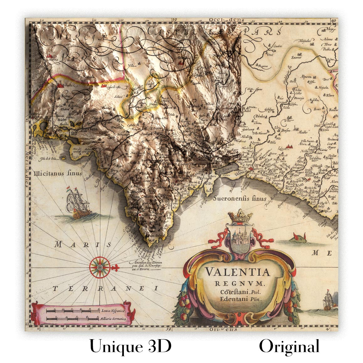
For something truly unique, this map is also available in "Unique 3D", our trademarked process that dramatically transforms the map so that it has a wonderful sense of depth. We combine the original map with detailed topography and elevation data, so that mountains and the terrain really "pop". For more info and examples of 3D maps, check my Unique 3D page.
For most orders, delivery time is about 3 working days. Personalised and customised products take longer, as I have to do the personalisation and send it to you for approval, which usually takes 1 or 2 days.
Please note that very large framed orders usually take longer to make and deliver.
If you need your order to arrive by a certain date, please contact me before you order so that we can find the best way of making sure you get your order in time.
I print and frame maps and artwork in 23 countries around the world. This means your order will be made locally, which cuts down on delivery time and ensures that it won't be damaged during delivery. You'll never pay customs or import duty, and we'll put less CO2 into the air.
All of my maps and art prints are well packaged and sent in a rugged tube if unframed, or surrounded by foam if framed.
I try to send out all orders within 1 or 2 days of receiving your order, though some products (like face masks, mugs and tote bags) can take longer to make.
If you select Express Delivery at checkout your order we will prioritise your order and send it out by 1-day courier (Fedex, DHL, UPS, Parcelforce).
Next Day delivery is also available in some countries (US, UK, Singapore, UAE) but please try to order early in the day so that we can get it sent out on time.
My standard frame is a gallery style black ash hardwood frame. It is simple and quite modern looking. My standard frame is around 20mm (0.8in) wide.
I use super-clear acrylic (perspex/acrylite) for the frame glass. It's lighter and safer than glass - and it looks better, as the reflectivity is lower.
Six standard frame colours are available for free (black, dark brown, dark grey, oak, white and antique gold). Custom framing and mounting/matting is available if you're looking for something else.
Most maps, art and illustrations are also available as a framed canvas. We use matte (not shiny) cotton canvas, stretch it over a sustainably sourced box wood frame, and then 'float' the piece within a wood frame. The end result is quite beautiful, and there's no glazing to get in the way.
All frames are provided "ready to hang", with either a string or brackets on the back. Very large frames will have heavy duty hanging plates and/or a mounting baton. If you have any questions, please get in touch.
See some examples of my framed maps and framed canvas maps.
Alternatively, I can also supply old maps and artwork on canvas, foam board, cotton rag and other materials.
If you want to frame your map or artwork yourself, please read my size guide first.
My maps are extremely high quality reproductions of original maps.
I source original, rare maps from libraries, auction houses and private collections around the world, restore them at my London workshop, and then use specialist giclée inks and printers to create beautiful maps that look even better than the original.
My maps are printed on acid-free archival matte (not glossy) paper that feels very high quality and almost like card. In technical terms the paper weight/thickness is 10mil/200gsm. It's perfect for framing.
I print with Epson ultrachrome giclée UV fade resistant pigment inks - some of the best inks you can find.
I can also make maps on canvas, cotton rag and other exotic materials.
Learn more about The Unique Maps Co.
Map personalisation
If you're looking for the perfect anniversary or housewarming gift, I can personalise your map to make it truly unique. For example, I can add a short message, or highlight an important location, or add your family's coat of arms.
The options are almost infinite. Please see my map personalisation page for some wonderful examples of what's possible.
To order a personalised map, select "personalise your map" before adding it to your basket.
Get in touch if you're looking for more complex customisations and personalisations.
Map ageing
I have been asked hundreds of times over the years by customers if they could buy a map that looks even older.
Well, now you can, by selecting Aged before you add a map to your basket.
All the product photos you see on this page show the map in its Original form. This is what the map looks like today.
If you select Aged, I will age your map by hand, using a special and unique process developed through years of studying old maps, talking to researchers to understand the chemistry of aging paper, and of course... lots of practice!
If you're unsure, stick to the Original colour of the map. If you want something a bit darker and older looking, go for Aged.
If you are not happy with your order for any reason, contact me for a no-quibble refund. Please see our returns and refund policy for more information.
I am very confident you will like your restored map or art print. I have been doing this since 1984. I'm a 5-star Etsy seller. I have sold tens of thousands of maps and art prints and have over 5,000 real 5-star reviews.
I use a unique process to restore maps and artwork that is massively time consuming and labour intensive. Hunting down the original maps and illustrations can take months. I use state of the art and eye-wateringly expensive technology to scan and restore them. As a result, I guarantee my maps and art prints are a cut above the rest - that's why I can offer a no-quibble refund.
Almost all of my maps and art prints look amazing at large sizes (200cm, 6.5ft+) and I can frame and deliver them to you as well, via special oversized courier. Contact me to discuss your specific needs.
Or try searching for something!


