


Old Map of the Americas by Visscher, 1690: Central America, Caribbean, Polynesia, Atlantic Islands, Amazon Rainforest
Buy 2, Get 1 More Free
If you add 2 items to your bag, you can add a third product for free. The discount is automatic - no code required.
This is equivalent to 33% off, which will be the largest discount available on my shop this year.
This works for all maps and artwork. You can order 3 of the same thing, or 3 different things.
Custom maps are excluded, as they're too time consuming to make and we'd prefer to take our time rather than rush through a lot of orders.
Contact me if you have any questions.
-
![]() Handmade in the UK (we're based in London)
Handmade in the UK (we're based in London)

-
FREE worldwide delivery in 2-3 days ⓘ
Free delivery in 2-3 days
Your map should be delivered in 2-3 working days with free delivery, worldwide.
We make maps by hand locally in 23 countries, including the UK
![]() . If you're buying a gift for someone in another country, we will make the map locally to them.
. If you're buying a gift for someone in another country, we will make the map locally to them.You will never pay import tax or customs duty.
Express delivery is available at checkout which can reduce the delivery time to 1-2 days.
Please note that personalised maps, and larger framed maps, can take longer to produce and deliver.
If you need your order to arrive by a certain date, contact me and we can discuss your options.
-
Complimentary gifting & design advice
ⓘ
Complimentary gifting & design advice
Available almost 24/7 on WhatsApp and email — we usually reply within minutes. We can help you:
- Choose a perfectly personalised gift
- Send a digital gift preview to the recipient
- Pick the ideal size for your wall
- Select the right finish and frame
Quick, friendly advice so you can order with confidence.
For last minute gifts, consider buying a digital gift card. We have over 5,000 maps and art prints to choose from.
-
90-day returns & 5-year guarantee
ⓘ
90-day returns & 5-year guarantee
Products can be returned within 90 days for a full refund, or exchange for another product.
We are also proud to offer a 5-year quality guarantee on our maps and art, covering defects in materials or workmanship under normal use.
For personalised and custom made items, we may offer you store credit or a non-expiring gift card, as we cannot resell personalised orders.
If you have any questions, get in touch. For more information, see our full returns & exchanges policy.

This is a museum-grade archival print from the original 1690 map — restored in our workshop and made to order on 220gsm archival matte paper or 400gsm artist's cotton canvas with pigment inks.
Professional framing & free personalisation available
1. Choose a size
2. Frame & personalise your map
Make your map unique with framing, hand-drawn customisation, vintage ageing, pop art text, unique 3D styling and more.


Gift message & custom finish

If you want to add a gift message, or a finish (jigsaw, aluminium board, etc.) that is not available here, please request it in the "order note" when you check out.
Every order is custom made, so if you need the size adjusted slightly, or printed on an unusual material, just let us know. We've done thousands of custom orders over the years, so there's (almost) nothing we can't manage.
You can also contact us before you order, if you prefer!

- Handmade locally. No import duty or tax
- FREE worldwide delivery
- 90-day returns & 5-year product guarantee
- Questions? WhatsApp me any time
Own a piece of history
7,000+ 5 star reviews


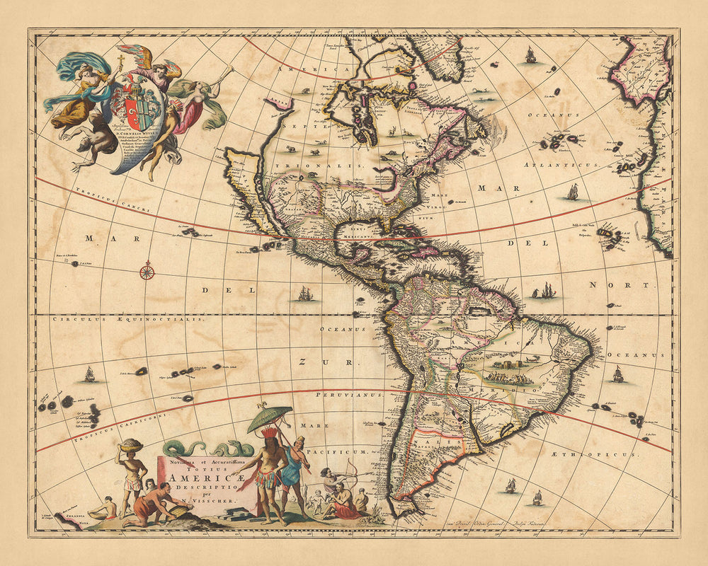
Unearth the rich tapestry of the Americas as seen through the eyes of Dutch cartographer Nicolaes Visscher II in 1690. Our offering, the 'Novissima et accuratissima totius Ameriae', or 'The Newest and Most Accurate Map of the Whole of America', is a breathtaking illustration of North and South America. This map, meticulously crafted by Visscher, the grandson of Claes Janszoon Visscher, a renowned mapmaker from the Dutch Golden Age, offers a unique perspective on the political and geographical divisions of the time.
Explore the vibrant Central America, the Caribbean's tropical charm, the vast expanse of the Amazon Rainforest, and the mystique of Polynesia and the Atlantic Islands. The map's unique hand coloring in outline and engraved details bring these regions to life, showcasing the cities, towns, waterways, canals, landmarks, and Indian settlements that made up the Western Hemisphere at the end of the 17th century.
Immerse yourself in the intricate details of this map, such as the depiction of California as an island and a small slice of New Zealand at the lower left corner. The open-ended Great Lake, conjectural Northwest Passage, and Straits of Anian add an element of exploration and discovery. The map's decorative cartouches, compass roses, and a vignette of natives in South America further enhance its visual appeal and historical significance.
This product is not just a map; it's a journey back in time, a testament to the artistry and geographical understanding of the Dutch Golden Age. The 'Novissima et accuratissima totius Ameriae' is a stunning piece of history, a conversation starter, and a perfect addition to the collection of any map enthusiast or history buff. With its rich details and accurate depiction of the Americas, it's a luxurious piece that invites viewers to explore, discover, and appreciate the world as it was seen over three centuries ago.
Some of the significant locations shown on this map:
North America:
- Quebec, Canada - Known as Ville-Marie, or "City of Mary," it is one of the oldest cities in North America and the only walled city north of Mexico.
- Boston, USA - Founded in 1630, it's one of the oldest cities in the U.S.
- New York, USA - Originally called New Amsterdam when it was a 17th-century Dutch settlement.
- Philadelphia, USA - Known as the "City of Brotherly Love," it was founded by William Penn in 1682.
- Charleston, USA - Founded in 1670 as Charles Town in honor of King Charles II of England.
- Salem, USA - Known for the infamous Salem witch trials of 1692.
- Santa Fe, USA - Founded in 1610, it's the oldest state capital in the United States.
- Havana, Cuba - Founded by the Spanish in the 16th century, it became one of the Caribbean's main centers for shipbuilding.
- St. Augustine, USA - Founded in 1565 by Spanish explorers, it's the oldest continuously inhabited European-established settlement in the continental United States.
South America:
- Bogota, Colombia - Originally called Santa Fe de Bogotá, it was founded by Gonzalo Jiménez de Quesada in 1538.
- Lima, Peru - Known as the "City of Kings," it was founded by Spanish conquistador Francisco Pizarro in 1535.
- Rio de Janeiro, Brazil - Founded in 1565 by the Portuguese, it's now known for its carnival festival.
- Santiago, Chile - Founded in 1541 by the Spanish conquistador Pedro de Valdivia.
- Buenos Aires, Argentina - Originally established as Ciudad de Nuestra Señora Santa María del Buen Ayre (City of Our Lady Saint Mary of the Fair Winds) in 1536.
- Asunción, Paraguay - One of the oldest cities in South America, it was founded in 1537 by Spanish explorer Juan de Salazar y Espinoza.
- Caracas, Venezuela - Founded in 1567 by Spanish explorer Diego de Losada.
- Quito, Ecuador - Known as San Francisco de Quito, it was founded by Spanish conquistador Sebastián de Belalcázar in 1534.
- Cuzco, Peru - The historic capital of the Inca Empire, it was captured by Spanish conquistadors in 1533.
Caribbean:
- Santo Domingo, Dominican Republic - Founded in 1496 by Bartholomew Columbus, brother of Christopher Columbus, it's the oldest continuously inhabited European settlement in the Americas.
- San Juan, Puerto Rico - Founded by Spanish colonists in 1521, who called it Ciudad de Puerto Rico ("Rich Port City").
- Port-au-Prince, Haiti - Founded in 1749, it's known for its French colonial architecture.
Central America:
- Panama City, Panama - Founded in 1519 by Spanish conquistador Pedro Arias Dávila, it was the starting point for expeditions that conquered the Inca Empire in Peru.
- San Salvador, El Salvador - Founded in 1525 by Spanish conquistador Pedro de Alvarado.
- Guatemala City, Guatemala - Founded in 1776, it's known for its Mayan history and high-altitude location.
- Tegucigalpa, Honduras - Founded by Spanish colonists as Real de Minas de San Miguel de Tegucigalpa in 1578.
- Managua, Nicaragua - Originally a pre-Columbian fishing town, the Spanish colonists made it a city in 1819.
- San José, Costa Rica - Founded in 1738 by order of Cabildo de León, its historical district, the Barrio Amón, is home to several historic and visual art displays.
- Belmopan, Belize - While it only became the capital city in 1970, the area known as Old Belize was inhabited by the Mayans and was a center of the ancient Maya civilization.
Notable Natural Phenomena:
- Amazon Rainforest - The world's largest rainforest, it's home to an incredibly diverse range of wildlife.
- Andes Mountains - The world's longest mountain range, running along South America's western side.
- Mississippi River - North America's second longest river, it was a significant transportation route in the 17th century.
- Niagara Falls - Located on the border of New York and Ontario, it's one of the most famous waterfalls in the world.
- Grand Canyon - Located in Arizona, it's one of the most famous examples of water erosion.
Notable Historical Events:
- The founding of the Massachusetts Bay Colony in 1628.
- The signing of the Treaty of Tordesillas in 1494, which divided the New World between Spain and Portugal.
- The Pueblo Revolt in 1680, where Pueblo people in modern-day New Mexico rose against Spanish colonizers.
Please double check the images to make sure that a specific town or place is shown on this map. You can also get in touch and ask us to check the map for you.
This map looks great at all sizes: 12x16in (30.5x41cm), 16x20in (40.5x51cm), 18x24in (45.5x61cm), 24x30in (61x76cm), 32x40in (81.5x102cm), 40x50in (102x127cm), 48x60in (122x153cm) and 56x70in (142x178cm), but it looks even better when printed large.
I can create beautiful, large prints of this map up to 90in (229cm). Please get in touch if you're looking for larger, customised or different framing options.
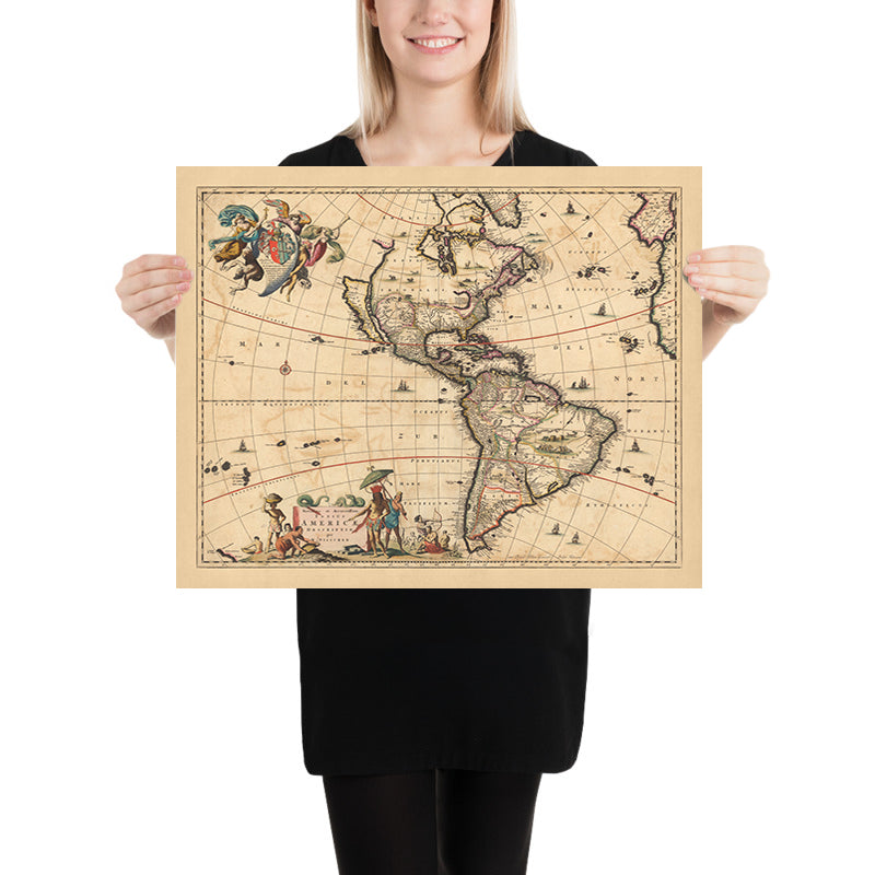
The model in the listing images is holding the 16x20in (40.5x51cm) version of this map.
The fifth listing image shows an example of my map personalisation service.
The labels on this map are very small at 12x16in (30.5x41cm). The map is still very attractive, but you may struggle to read the smallest letters. Please buy a larger map if it's important to be able to read the map easily.
If you’re looking for something slightly different, check out my collection of the best old maps of Europe and European cities to see if something else catches your eye.
Please contact me to check if a certain location, landmark or feature is shown on this map.
This would make a wonderful birthday, Christmas, Father's Day, work leaving, anniversary or housewarming gift for someone from the areas covered by this map.
This map is available as a giclée print on acid free archival matte paper, or you can buy it framed. The frame is a nice, simple black frame that suits most aesthetics. Please get in touch if you'd like a different frame colour or material. My frames are glazed with super-clear museum-grade acrylic (perspex/acrylite), which is significantly less reflective than glass, safer, and will always arrive in perfect condition.
This map is also available as a float framed canvas, sometimes known as a shadow gap framed canvas or canvas floater. The map is printed on artist's cotton canvas and then stretched over a handmade box frame. We then "float" the canvas inside a wooden frame, which is available in a range of colours (black, dark brown, oak, antique gold and white). This is a wonderful way to present a map without glazing in front. See some examples of float framed canvas maps and explore the differences between my different finishes.
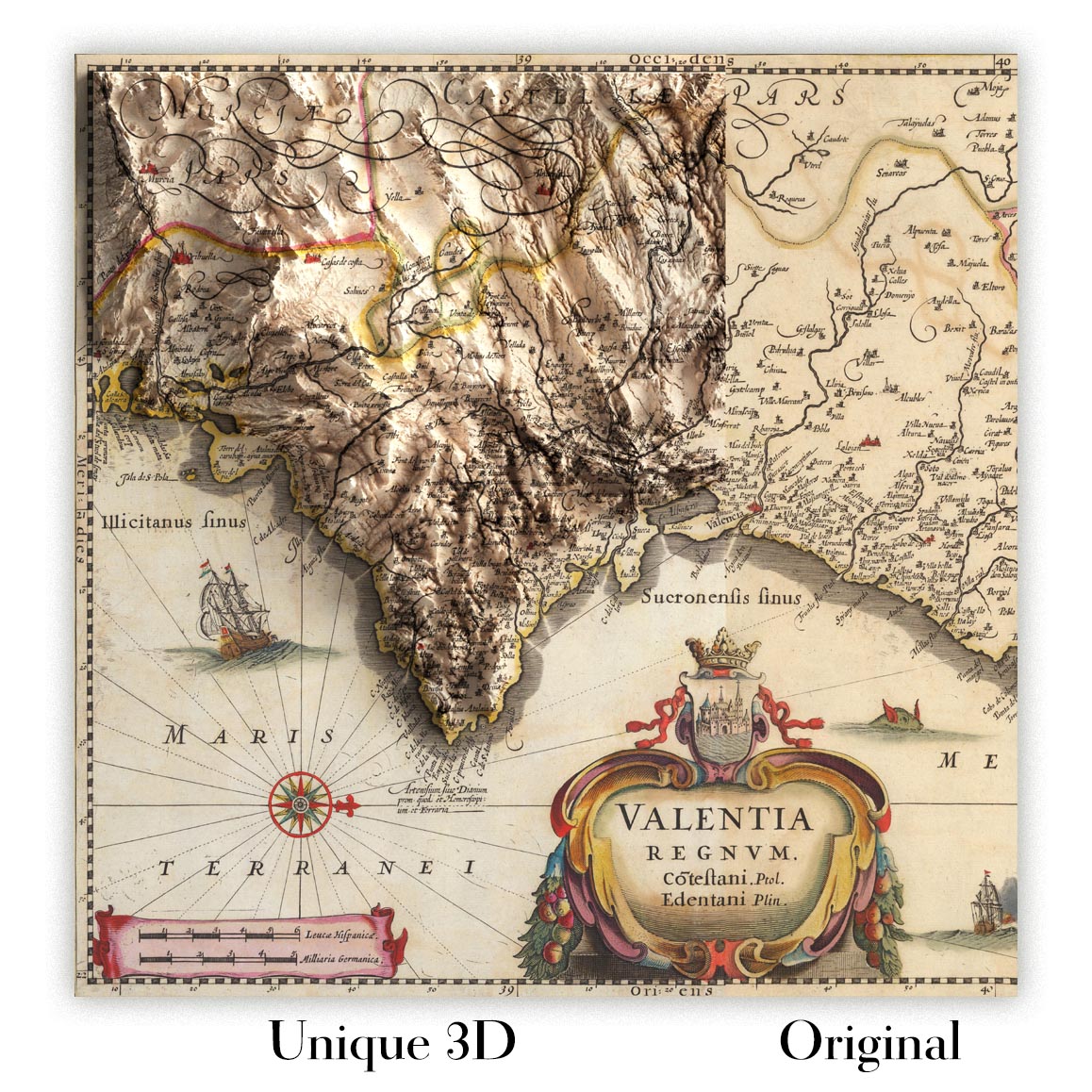
For something truly unique, this map is also available in "Unique 3D", our trademarked process that dramatically transforms the map so that it has a wonderful sense of depth. We combine the original map with detailed topography and elevation data, so that mountains and the terrain really "pop". For more info and examples of 3D maps, check my Unique 3D page.
For most orders, delivery time is about 3 working days. Personalised and customised products take longer, as I have to do the personalisation and send it to you for approval, which usually takes 1 or 2 days.
Please note that very large framed orders usually take longer to make and deliver.
If you need your order to arrive by a certain date, please contact me before you order so that we can find the best way of making sure you get your order in time.
I print and frame maps and artwork in 23 countries around the world. This means your order will be made locally, which cuts down on delivery time and ensures that it won't be damaged during delivery. You'll never pay customs or import duty, and we'll put less CO2 into the air.
All of my maps and art prints are well packaged and sent in a rugged tube if unframed, or surrounded by foam if framed.
I try to send out all orders within 1 or 2 days of receiving your order, though some products (like face masks, mugs and tote bags) can take longer to make.
If you select Express Delivery at checkout your order we will prioritise your order and send it out by 1-day courier (Fedex, DHL, UPS, Parcelforce).
Next Day delivery is also available in some countries (US, UK, Singapore, UAE) but please try to order early in the day so that we can get it sent out on time.
My standard frame is a gallery style black ash hardwood frame. It is simple and quite modern looking. My standard frame is around 20mm (0.8in) wide.
I use super-clear acrylic (perspex/acrylite) for the frame glass. It's lighter and safer than glass - and it looks better, as the reflectivity is lower.
Six standard frame colours are available for free (black, dark brown, dark grey, oak, white and antique gold). Custom framing and mounting/matting is available if you're looking for something else.
Most maps, art and illustrations are also available as a framed canvas. We use matte (not shiny) cotton canvas, stretch it over a sustainably sourced box wood frame, and then 'float' the piece within a wood frame. The end result is quite beautiful, and there's no glazing to get in the way.
All frames are provided "ready to hang", with either a string or brackets on the back. Very large frames will have heavy duty hanging plates and/or a mounting baton. If you have any questions, please get in touch.
See some examples of my framed maps and framed canvas maps.
Alternatively, I can also supply old maps and artwork on canvas, foam board, cotton rag and other materials.
If you want to frame your map or artwork yourself, please read my size guide first.
My maps are extremely high quality reproductions of original maps.
I source original, rare maps from libraries, auction houses and private collections around the world, restore them at my London workshop, and then use specialist giclée inks and printers to create beautiful maps that look even better than the original.
My maps are printed on acid-free archival matte (not glossy) paper that feels very high quality and almost like card. In technical terms the paper weight/thickness is 10mil/200gsm. It's perfect for framing.
I print with Epson ultrachrome giclée UV fade resistant pigment inks - some of the best inks you can find.
I can also make maps on canvas, cotton rag and other exotic materials.
Learn more about The Unique Maps Co.
Map personalisation
If you're looking for the perfect anniversary or housewarming gift, I can personalise your map to make it truly unique. For example, I can add a short message, or highlight an important location, or add your family's coat of arms.
The options are almost infinite. Please see my map personalisation page for some wonderful examples of what's possible.
To order a personalised map, select "personalise your map" before adding it to your basket.
Get in touch if you're looking for more complex customisations and personalisations.
Map ageing
I have been asked hundreds of times over the years by customers if they could buy a map that looks even older.
Well, now you can, by selecting Aged before you add a map to your basket.
All the product photos you see on this page show the map in its Original form. This is what the map looks like today.
If you select Aged, I will age your map by hand, using a special and unique process developed through years of studying old maps, talking to researchers to understand the chemistry of aging paper, and of course... lots of practice!
If you're unsure, stick to the Original colour of the map. If you want something a bit darker and older looking, go for Aged.
If you are not happy with your order for any reason, contact me and I'll get it fixed ASAP, free of charge. Please see my returns and refund policy for more information.
I am very confident you will like your restored map or art print. I have been doing this since 1984. I'm a 5-star Etsy seller. I have sold tens of thousands of maps and art prints and have over 5,000 real 5-star reviews. My work has been featured in interior design magazines, on the BBC, and on the walls of dozens of 5-star hotels.
I use a unique process to restore maps and artwork that is massively time consuming and labour intensive. Hunting down the original maps and illustrations can take months. I use state of the art and eye-wateringly expensive technology to scan and restore them. As a result, I guarantee my maps and art prints are a cut above the rest. I stand by my products and will always make sure you're 100% happy with what you receive.
Almost all of my maps and art prints look amazing at large sizes (200cm, 6.5ft+) and I can frame and deliver them to you as well, via special oversized courier. Contact me to discuss your specific needs.
Or try searching for something!


