

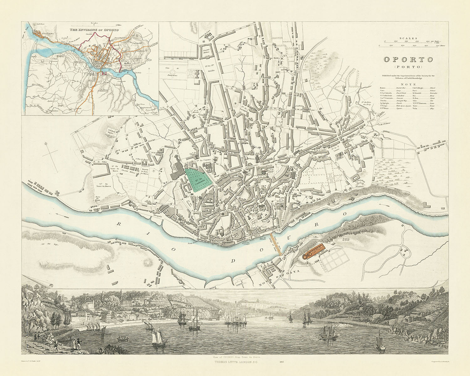
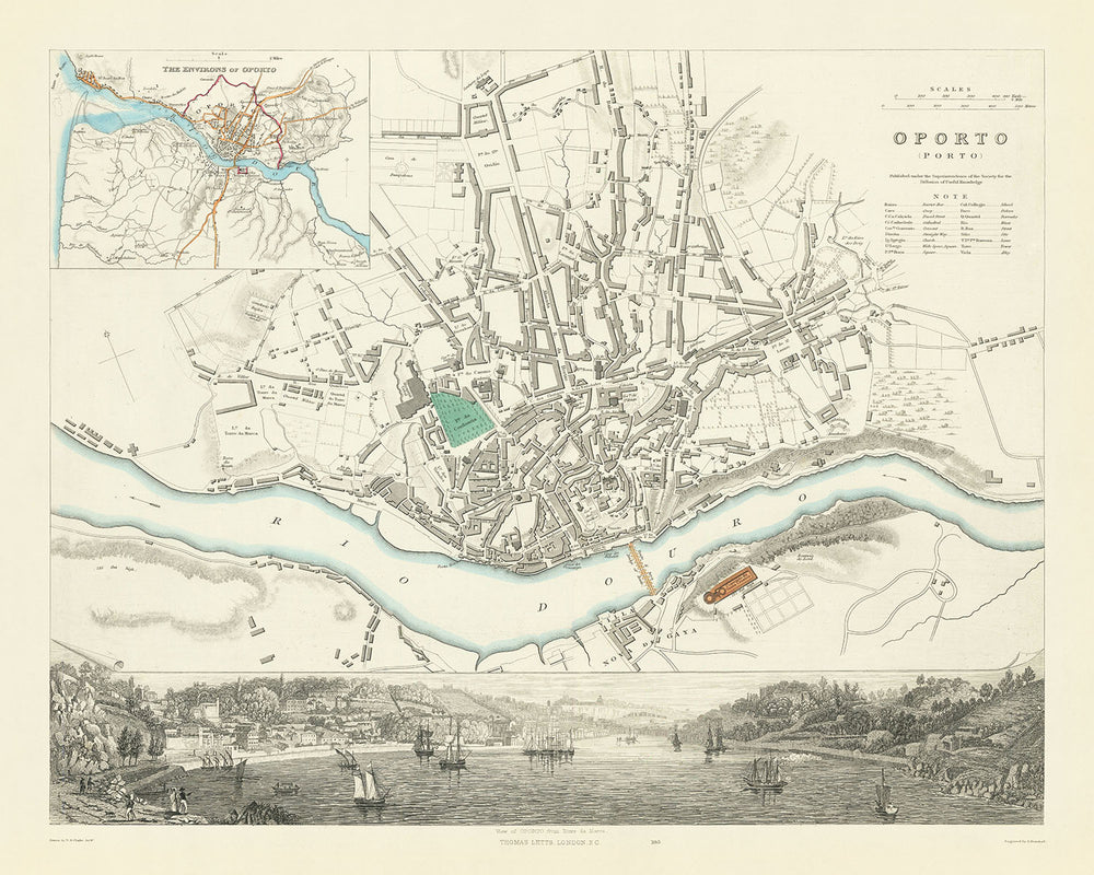


Old Map of Porto, 1870: Torre da Marca, Cathedral, Ribeira Square, St. Francis Church, Episcopal Palace
Spend £250, Save £50 Christmas Express Delivery available at checkout
Spend £250, Save £50

-
![]() Handmade in the UK (we're based in London)
Handmade in the UK (we're based in London)
-
FREE delivery in 3-4 days ⓘ
Free delivery in 3-4 days
Your map should be delivered in 3-4 working days with free delivery, worldwide.
Please use Express Delivery at checkout for Christmas orders. Framed orders may arrive with Express Delivery, but it is not guaranteed.
New for 2025: After you order, you can send a beautiful gift preview by email, if you're worried it won't arrive on time.
We make maps by hand locally in 23 countries, including the UK
![]() . If you're buying a gift for someone in another country, we will make the map locally to them.
. If you're buying a gift for someone in another country, we will make the map locally to them.You will never pay import tax or customs duty.
Check the Christmas delivery guide for order deadlines. Delivery times are starting to slow down, and will continue to slow down towards Christmas.
Express delivery is available at checkout which can reduce the delivery time to 1-2 days.
Please note that personalised maps, and larger framed maps, can take longer to produce and deliver.
If you need your order to arrive by a certain date, contact me and we can discuss your options.
-
FREE gift preview
ⓘ
Digital gift preview
New for 2025: After you complete your order, you can send a beautiful digital preview to the gift recipient. Just provide their email address and we'll do the rest. (Their email address will not be stored or used for any other purpose.)
This is perfect for Christmas gifting, particularly if you're concerned that your order might not arrive in time for Christmas.
-
90 day money back guarantee
ⓘ
90 days to return and refund
Products can be returned within 90 days for a full refund, or exchange for another product.
For personalised and custom made items, we may offer you store credit or a non-expiring gift card, as we cannot resell personalised orders.
If you have any questions, get in touch. For more information, see our full returns & exchanges policy.

My maps are rare, museum-grade, restored old maps sourced from libraries, auction houses and private collections across the globe.
Framing & free personalisation available
1. Select your size
2. Frame & personalise your map
There is limited framing & personalisation capacity available. Order by 10am tomorrow for Christmas delivery.


Gift message & custom finish

If you want to add a gift message, or a finish (jigsaw, aluminium board, etc.) that is not available here, please request it in the "order note" when you check out.
Every order is custom made, so if you need the size adjusted slightly, or printed on an unusual material, just let us know. We've done thousands of custom orders over the years, so there's (almost) nothing we can't manage.
You can also contact us before you order, if you prefer!

- Handmade locally. No import duty or tax
- FREE Delivery by Christmas
- Love it or your money back (90 days)
- Questions? WhatsApp me any time
Own a piece of history
5,000+ 5 star reviews


Discover the Historical Elegance of Porto through the "Antique Map of Porto, Portugal"
Immerse yourself in the rich tapestry of Porto with the "Antique Map of Porto, Portugal," a masterpiece produced in 1870 by the Society for the Diffusion of Useful Knowledge (SDUK). This map is not just a navigational tool but a historical document that captures Porto during a pivotal era of industrialization. The map features a meticulously detailed plan of the city, highlighting significant neighborhoods such as Bairro Alto, Cedofeita, and Miragaia. Each area is depicted with such precision that one can almost hear the bustling streets and see the vibrant life of 19th-century Porto.
A Panoramic View from the Historical Torre da Marca
One of the map's most captivating features is the panoramic birdseye illustration of Porto as viewed from the iconic Torre da Marca. This illustration below the main city map provides a unique perspective, offering a glimpse into the urban landscape and the daily lives of its inhabitants. The map details various landmarks, including the majestic Cathedral, the bustling Ribeira Square, and the ornate Episcopal Palace, making it an invaluable resource for those interested in the architectural and cultural history of the city.
Landmarks and Streets: A Cartographic Chronicle
The "Antique Map of Porto, Portugal" goes beyond mere geography. It serves as a chronicle of the city's rich heritage, with detailed depictions of streets like Flores and Cedofeita and landmarks such as St. Francis Church and the Carmelite Convent. Each street and landmark tells a story, reflecting the city's historical depth and the map's utility in studying urban development during a time of significant change.
The Artistry and Accuracy of SDUK Cartography
The Society for the Diffusion of Useful Knowledge, renowned for its commitment to educational publishing, ensured that this map exemplified the highest standards of British cartography in the 19th century. The traditional style, with hand-drawn lines and symbols, not only adds to the map's aesthetic appeal but also its accuracy and attention to detail. This map is a testament to the SDUK's mission to disseminate knowledge and contribute to the betterment of society through precise and informative maps.
A Collector's Delight and a Historian's Treasure
For collectors and historians alike, the "Antique Map of Porto, Portugal" is more than a decorative item; it is a portal to the past. It offers a unique opportunity to own a piece of history, to explore Porto as it was over a century ago, and to appreciate the artistry involved in its creation. This map is not only a significant historical document but also a reflection of the high quality of British cartography, making it a prized possession for anyone fascinated by maps, history, or the enchanting city of Porto.
Streets and Roads on this Map
- Agiun
- Alegria
- Almada
- Andre
- Antonio
- Areias
- Assumpcao
- Bandeirinha
- Barredo
- Boa Nova
- Boa Vista
- Bom Jardim
- C. dos Clerigos
- Calcada da Boa Vista
- Calcada das Virtudes
- Calvario
- Campo do Poco das Patas
- Cancella Velh
- Carmo
- Carregal
- Carreira
- Carvalhoza
- Casa de Paraiso
- Cathedral
- Cedofeita
- Cimo de Villa Nova
- Corticeira
- Crux d'Regateira
- D. Joao da Foz
- Descarga
- Direita
- Doca
- Doida
- Estivao
- Falaica de Tabaco
- Farinha
- Ferradores
- Figueirinhas
- Flores
- Formosa
- Freixo
- General
- Goncalo Cristovao
- Grillo
- Grimalde
- Hortas
- Laranjal
- Lavoradouros
- Lazaro
- Limoeiro
- Lordelo
- Magdalena
- Mal
- Mar
- Martim Moniz
- Miguel
- Miragaia
- Monte d'Aguia
- Moreira
- Mousinho da Silveira
- Muzas
- Natiodadez
- Nova
- Nova dos Inglezes
- Olival
- Oporto
- Ourem
- Paraiso
- Pedras Negras
- Pedro Hispano
- Picaria
- Pinheiro
- Pochinbo
- Ponte d'Arca
- Postigo do Sol
- Prata
- Principe
- Quebrantoens
- Remolao
- Ribeiro
- Rosario
- Rua Nova
- Ruas Guimaraes
- Salgueiro
- Salvador
- Sande
- Santa Catherina
- Santa Clara
- Santa Ildefonso
- Santa Marinha
- Santa Thereza
- Santo Antonio
- Santo Ovidio
- Sao Joao
- Sao Joao Baptista
- Sao Joao Novo
- Sao Lazaro
- Sao Lourenco
- Sao Miguel
- Sao Pedro
- Sao Vicente
- Senhor Bom Fim
- Senhora da Lapa
- Sol
- T. dos Clerigos
- Taipas
- Terreiro
- Torrinha
- Torre da Marca
- Trapiche
- Trindade
- Val de Piedade
- Viela
- Vinagre
- Virtudes
Notable Features & Landmarks
- Inset maps: Environs of Oporto
- Illustrations: View of Oporto from Torre da Marca
- Landmarks: Torre da Marca, Church of St Christovao, Seminary of the Bispo, Carmelite Convent, St. Francis Church, Episcopal Palace, Cathedral, St. John's Church, New Custom House, Exchange, Theatre, Barracks, Ribeira Square, Custom House, Bolsa, St. Francis Church, St. Anthony's Church, Church of the Clerigos, St. Ildefonso Church, St. Lazarus Hospital, Capuchin Convent, Bom Fim Orphanage, New Market, St. Catherine's Church, St. Michael's Church, Carmelite Church, St. Benedict's Convent, St. Dominic's Church, St. Clara's Convent, New Bridge, Fonte Nova Fountain, Arcada Fountain, St. John's Bridge, Wellesley Fountain, Lord Wellington's Battery
- Neighbourhoods: Bairro Alto, Cedofeita, Miragaia, Sao Nicolau, Vitoria
Historical and Design Context
- Highly detailed plan of Porto, including a large panoramic birdseye illustration of the City from Torre da Marca, below the main city map.
- One of the best 19th Century English town plans to appear in a commercial atlas.
- Published by the Society for the Diffusion of Useful Knowledge (SDUK), a British learned society founded in 1826 aimed at disseminating knowledge to improve living conditions.
- The map is an example of the high quality of British cartography in the 19th century.
- Provides a snapshot of Porto at a time when the city was undergoing rapid industrialization.
Please double check the images to make sure that a specific town or place is shown on this map. You can also get in touch and ask us to check the map for you.
This map looks great at every size, but I always recommend going for a larger size if you have space. That way you can easily make out all of the details.
This map looks amazing at sizes all the way up to 70in (180cm). If you are looking for a larger map, please get in touch.
The model in the listing images is holding the 16x20in (40x50cm) version of this map.
The fifth listing image shows an example of my map personalisation service.
If you’re looking for something slightly different, check out my collection of the best old maps to see if something else catches your eye.
Please contact me to check if a certain location, landmark or feature is shown on this map.
This would make a wonderful birthday, Christmas, Father's Day, work leaving, anniversary or housewarming gift for someone from the areas covered by this map.
This map is available as a giclée print on acid free archival matte paper, or you can buy it framed. The frame is a nice, simple black frame that suits most aesthetics. Please get in touch if you'd like a different frame colour or material. My frames are glazed with super-clear museum-grade acrylic (perspex/acrylite), which is significantly less reflective than glass, safer, and will always arrive in perfect condition.
This map is also available as a float framed canvas, sometimes known as a shadow gap framed canvas or canvas floater. The map is printed on artist's cotton canvas and then stretched over a handmade box frame. We then "float" the canvas inside a wooden frame, which is available in a range of colours (black, dark brown, oak, antique gold and white). This is a wonderful way to present a map without glazing in front. See some examples of float framed canvas maps and explore the differences between my different finishes.
For something truly unique, this map is also available in "Unique 3D", our trademarked process that dramatically transforms the map so that it has a wonderful sense of depth. We combine the original map with detailed topography and elevation data, so that mountains and the terrain really "pop". For more info and examples of 3D maps, check my Unique 3D page.
For most orders, delivery time is about 3 working days. Personalised and customised products take longer, as I have to do the personalisation and send it to you for approval, which usually takes 1 or 2 days.
Please note that very large framed orders usually take longer to make and deliver.
If you need your order to arrive by a certain date, please contact me before you order so that we can find the best way of making sure you get your order in time.
I print and frame maps and artwork in 23 countries around the world. This means your order will be made locally, which cuts down on delivery time and ensures that it won't be damaged during delivery. You'll never pay customs or import duty, and we'll put less CO2 into the air.
All of my maps and art prints are well packaged and sent in a rugged tube if unframed, or surrounded by foam if framed.
I try to send out all orders within 1 or 2 days of receiving your order, though some products (like face masks, mugs and tote bags) can take longer to make.
If you select Express Delivery at checkout your order we will prioritise your order and send it out by 1-day courier (Fedex, DHL, UPS, Parcelforce).
Next Day delivery is also available in some countries (US, UK, Singapore, UAE) but please try to order early in the day so that we can get it sent out on time.
My standard frame is a gallery style black ash hardwood frame. It is simple and quite modern looking. My standard frame is around 20mm (0.8in) wide.
I use super-clear acrylic (perspex/acrylite) for the frame glass. It's lighter and safer than glass - and it looks better, as the reflectivity is lower.
Six standard frame colours are available for free (black, dark brown, dark grey, oak, white and antique gold). Custom framing and mounting/matting is available if you're looking for something else.
Most maps, art and illustrations are also available as a framed canvas. We use matte (not shiny) cotton canvas, stretch it over a sustainably sourced box wood frame, and then 'float' the piece within a wood frame. The end result is quite beautiful, and there's no glazing to get in the way.
All frames are provided "ready to hang", with either a string or brackets on the back. Very large frames will have heavy duty hanging plates and/or a mounting baton. If you have any questions, please get in touch.
See some examples of my framed maps and framed canvas maps.
Alternatively, I can also supply old maps and artwork on canvas, foam board, cotton rag and other materials.
If you want to frame your map or artwork yourself, please read my size guide first.
My maps are extremely high quality reproductions of original maps.
I source original, rare maps from libraries, auction houses and private collections around the world, restore them at my London workshop, and then use specialist giclée inks and printers to create beautiful maps that look even better than the original.
My maps are printed on acid-free archival matte (not glossy) paper that feels very high quality and almost like card. In technical terms the paper weight/thickness is 10mil/200gsm. It's perfect for framing.
I print with Epson ultrachrome giclée UV fade resistant pigment inks - some of the best inks you can find.
I can also make maps on canvas, cotton rag and other exotic materials.
Learn more about The Unique Maps Co.
Map personalisation
If you're looking for the perfect anniversary or housewarming gift, I can personalise your map to make it truly unique. For example, I can add a short message, or highlight an important location, or add your family's coat of arms.
The options are almost infinite. Please see my map personalisation page for some wonderful examples of what's possible.
To order a personalised map, select "personalise your map" before adding it to your basket.
Get in touch if you're looking for more complex customisations and personalisations.
Map ageing
I have been asked hundreds of times over the years by customers if they could buy a map that looks even older.
Well, now you can, by selecting Aged before you add a map to your basket.
All the product photos you see on this page show the map in its Original form. This is what the map looks like today.
If you select Aged, I will age your map by hand, using a special and unique process developed through years of studying old maps, talking to researchers to understand the chemistry of aging paper, and of course... lots of practice!
If you're unsure, stick to the Original colour of the map. If you want something a bit darker and older looking, go for Aged.
If you are not happy with your order for any reason, contact me and I'll get it fixed ASAP, free of charge. Please see my returns and refund policy for more information.
I am very confident you will like your restored map or art print. I have been doing this since 1984. I'm a 5-star Etsy seller. I have sold tens of thousands of maps and art prints and have over 5,000 real 5-star reviews. My work has been featured in interior design magazines, on the BBC, and on the walls of dozens of 5-star hotels.
I use a unique process to restore maps and artwork that is massively time consuming and labour intensive. Hunting down the original maps and illustrations can take months. I use state of the art and eye-wateringly expensive technology to scan and restore them. As a result, I guarantee my maps and art prints are a cut above the rest. I stand by my products and will always make sure you're 100% happy with what you receive.
Almost all of my maps and art prints look amazing at large sizes (200cm, 6.5ft+) and I can frame and deliver them to you as well, via special oversized courier. Contact me to discuss your specific needs.
Or try searching for something!


