

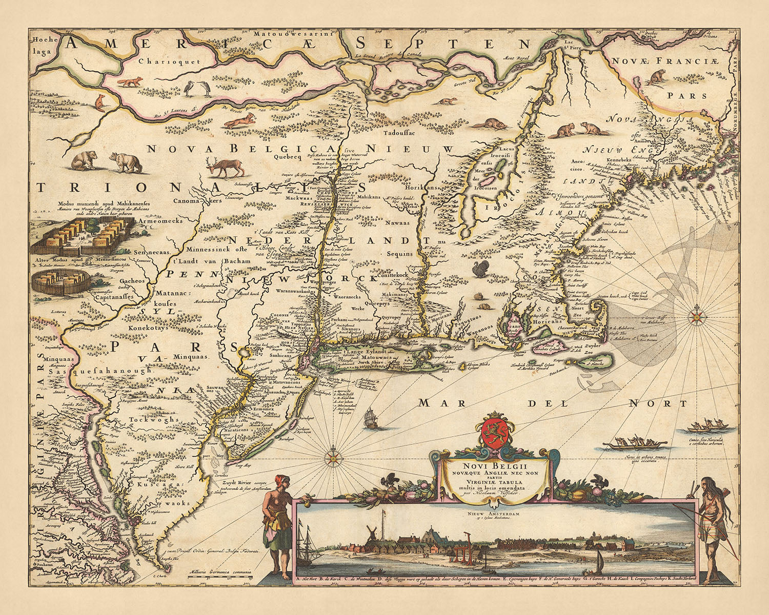


Old Map of New Netherland, New England and Part of Virginia by Visscher, 1690: New York, New Amsterdam, Indian Settlements
Christmas Express Delivery
You can order up until 10am on December 22 with Express Delivery to receive your order by Christmas.
Unframed products are much more likely to arrive by Christmas. Framed products may arrive on time, but they move more slowly, particularly when couriers are so overloaded with packages.
Personalised orders are unlikely to arrive on time (but if you absolutely must have a personalised product, please contact me and I'll do my best to help!)
Contact me for info on last-minute deliveries.
Spend £250, Save £50 Christmas Express Delivery available
Christmas Express Delivery
You can order up until 10am on December 22 with Express Delivery to receive your order by Christmas.
Unframed products are much more likely to arrive by Christmas. Framed products may arrive on time, but they move more slowly, particularly when couriers are so overloaded with packages.
Personalised orders are unlikely to arrive on time (but if you absolutely must have a personalised product, please contact me and I'll do my best to help!)
Contact me for info on last-minute deliveries.
Spend £250, Save £50

-
![]() Handmade in the UK (we're based in London)
Handmade in the UK (we're based in London)
-
FREE delivery in 3-4 days ⓘ
Free delivery in 3-4 days
Your map should be delivered in 3-4 working days with free delivery, worldwide.
Please use Express Delivery at checkout for Christmas orders. Framed orders may arrive with Express Delivery, but it is not guaranteed.
New for 2025: After you order, you can send a beautiful gift preview by email, if you're worried it won't arrive on time.
We make maps by hand locally in 23 countries, including the UK
![]() . If you're buying a gift for someone in another country, we will make the map locally to them.
. If you're buying a gift for someone in another country, we will make the map locally to them.You will never pay import tax or customs duty.
Check the Christmas delivery guide for order deadlines. Delivery times are starting to slow down, and will continue to slow down towards Christmas.
Express delivery is available at checkout which can reduce the delivery time to 1-2 days.
Please note that personalised maps, and larger framed maps, can take longer to produce and deliver.
If you need your order to arrive by a certain date, contact me and we can discuss your options.
-
FREE gift preview
ⓘ
Digital gift preview
New for 2025: After you complete your order, you can send a beautiful digital preview to the gift recipient. Just provide their email address and we'll do the rest. (Their email address will not be stored or used for any other purpose.)
This is perfect for Christmas gifting, particularly if you're concerned that your order might not arrive in time for Christmas.
-
90 day money back guarantee
ⓘ
90 days to return and refund
Products can be returned within 90 days for a full refund, or exchange for another product.
For personalised and custom made items, we may offer you store credit or a non-expiring gift card, as we cannot resell personalised orders.
If you have any questions, get in touch. For more information, see our full returns & exchanges policy.

My maps are rare, museum-grade, restored old maps sourced from libraries, auction houses and private collections across the globe.
Framing & free personalisation available
1. Select your size
2. Frame & personalise your map
There is limited framing & personalisation capacity available. Order by 10am tomorrow for Christmas delivery.


Gift message & custom finish

If you want to add a gift message, or a finish (jigsaw, aluminium board, etc.) that is not available here, please request it in the "order note" when you check out.
Every order is custom made, so if you need the size adjusted slightly, or printed on an unusual material, just let us know. We've done thousands of custom orders over the years, so there's (almost) nothing we can't manage.
You can also contact us before you order, if you prefer!

- Handmade locally. No import duty or tax
- FREE Delivery by Christmas
- Love it or your money back (90 days)
- Questions? WhatsApp me any time
Own a piece of history
5,000+ 5 star reviews


Immerse yourself in the grandeur of the past with the 'Atlas minor sive totius orbis terrarum contracta delinea ex conatibus Nico', or in English, 'Minor Atlas or a contracted delineation of the whole world undertaken by Nico'. This is a map that presents a snapshot of the world as it was understood in 1690, meticulously crafted by the esteemed cartographer Nicolaes Visscher II. It is a testament to the Dutch Golden Age, a period renowned for its significant contributions to cartography, when Visscher's grandfather, Claes Janszoon Visscher, laid the foundation for the family's legacy in the field.
This map, with its focus on "New Netherland and New England and part of Virginia", offers a fascinating look at the early stages of the United States' development. The regions highlighted on this map include present-day New York, New Jersey, Washington, and Massachusetts, offering a window into the past of these significant states. The White Mountain National Forest, a beloved natural landmark, is also captured in this historical representation, a testament to the enduring beauty of this landscape.
The map is adorned with intricate details that speak volumes about the era it represents. An inset view of New York City, then known as "New Amsterdam", is a highlight of this map. Manhattan, accurately depicted as an island, is marked with a settlement at its southern end. The map also features a variety of cities, towns, waterways, and canals, each rendered with the meticulous attention to detail that was characteristic of Visscher's work.
In addition to these geographical details, the map also features decorative cartouches, compass roses, and a vignette of American Indian settlements and wildlife, providing a glimpse into the rich cultural history of the region. The relief of the terrain is depicted pictorially, adding depth and dimension to this historical piece. The 'Atlas minor sive totius orbis terrarum contracta delinea ex conatibus Nico' is more than just a map; it is a journey through time, a piece of history that offers a unique perspective on the world as it was understood over three centuries ago.
Some of the significant locations shown on this map:
New Netherland
- New Amsterdam (Modern-day New York City): The Dutch West India Company established this city in 1624. It was the main city of the New Netherland colony.
- Beverwijck (Modern-day Albany): Founded in 1652, it was the second largest settlement in New Netherland.
- Fort Orange (Modern-day Albany): Established in 1624, it was the first permanent Dutch settlement in New Netherland.
- Breuckelen (Modern-day Brooklyn): Founded in 1646, it was the first municipality in what is now New York state.
- Rensselaerswyck (Modern-day Rensselaer County): Established in 1630, it was a patroonship that became the most successful Dutch colony in New Netherland.
New England
- Boston: Founded in 1630, it was one of the oldest cities in the United States and the largest city in New England.
- Plymouth: Established in 1620 by the Pilgrims, it was the first successful English colony in New England.
- Salem: Founded in 1626, it was notable for the Salem witch trials in 1692.
- Providence: Established in 1636, it was one of the first cities in the country to industrialize.
- Hartford: Founded in 1635, it is known as the "Insurance Capital of the World" due to the many insurance companies headquartered there.
Virginia
- Jamestown: Established in 1607, it was the first permanent English settlement in the Americas.
- Williamsburg: Founded in 1632, it was the capital of the Virginia Colony from 1699 to 1780.
- Yorktown: Established in 1691, it was the site of the final battle of the American Revolutionary War.
- Henricus: Founded in 1611, it was the second successful English settlement in the New World.
- Kecoughtan (Modern-day Hampton): Established in 1610, it was one of the oldest English-speaking communities in the United States.
Notable natural phenomena and boundaries:
- Hudson River: A 315-mile river that flows from north to south through eastern New York.
- Delaware River: Named after Thomas West, 3rd Baron De La Warr, it is a major river on the Atlantic coast of the United States.
- Appalachian Mountains: A mountain range in the eastern North America, extending from Canada to Alabama.
- Chesapeake Bay: The largest estuary in the United States, known for its beauty and bounty of seafood.
- Long Island Sound: A tidal estuary of the Atlantic Ocean, lying between the eastern shores of Bronx County, New York City, southern Westchester County, and Connecticut to the north, and the North Shore of Long Island, to the south.
Notable historical events:
- Founding of Jamestown (1607): The first permanent English settlement in the Americas.
- Pequot War (1636-1638): An armed conflict between the Pequot tribe and an alliance of the English colonists of the Massachusetts Bay, Plymouth, and Saybrook colonies.
- King Philip's War (1675-1678): An armed conflict between Native American inhabitants of present-day New England and English colonists and their Native American allies.
Please double check the images to make sure that a specific town or place is shown on this map. You can also get in touch and ask us to check the map for you.
This map looks great at all sizes: 12x16in (30.5x41cm), 16x20in (40.5x51cm), 18x24in (45.5x61cm), 24x30in (61x76cm), 32x40in (81.5x102cm), 40x50in (102x127cm), 48x60in (122x153cm) and 56x70in (142x178cm), but it looks even better when printed large.
I can create beautiful, large prints of this map up to 90in (229cm). Please get in touch if you're looking for larger, customised or different framing options.
The model in the listing images is holding the 16x20in (40.5x51cm) version of this map.
The fifth listing image shows an example of my map personalisation service.
If you’re looking for something slightly different, check out my collection of the best old maps of Europe and European cities to see if something else catches your eye.
Please contact me to check if a certain location, landmark or feature is shown on this map.
This would make a wonderful birthday, Christmas, Father's Day, work leaving, anniversary or housewarming gift for someone from the areas covered by this map.
This map is available as a giclée print on acid free archival matte paper, or you can buy it framed. The frame is a nice, simple black frame that suits most aesthetics. Please get in touch if you'd like a different frame colour or material. My frames are glazed with super-clear museum-grade acrylic (perspex/acrylite), which is significantly less reflective than glass, safer, and will always arrive in perfect condition.
This map is also available as a float framed canvas, sometimes known as a shadow gap framed canvas or canvas floater. The map is printed on artist's cotton canvas and then stretched over a handmade box frame. We then "float" the canvas inside a wooden frame, which is available in a range of colours (black, dark brown, oak, antique gold and white). This is a wonderful way to present a map without glazing in front. See some examples of float framed canvas maps and explore the differences between my different finishes.
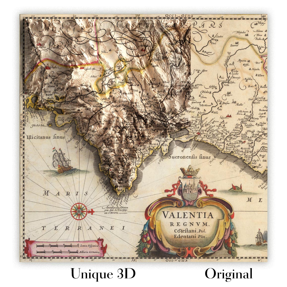
For something truly unique, this map is also available in "Unique 3D", our trademarked process that dramatically transforms the map so that it has a wonderful sense of depth. We combine the original map with detailed topography and elevation data, so that mountains and the terrain really "pop". For more info and examples of 3D maps, check my Unique 3D page.
For most orders, delivery time is about 3 working days. Personalised and customised products take longer, as I have to do the personalisation and send it to you for approval, which usually takes 1 or 2 days.
Please note that very large framed orders usually take longer to make and deliver.
If you need your order to arrive by a certain date, please contact me before you order so that we can find the best way of making sure you get your order in time.
I print and frame maps and artwork in 23 countries around the world. This means your order will be made locally, which cuts down on delivery time and ensures that it won't be damaged during delivery. You'll never pay customs or import duty, and we'll put less CO2 into the air.
All of my maps and art prints are well packaged and sent in a rugged tube if unframed, or surrounded by foam if framed.
I try to send out all orders within 1 or 2 days of receiving your order, though some products (like face masks, mugs and tote bags) can take longer to make.
If you select Express Delivery at checkout your order we will prioritise your order and send it out by 1-day courier (Fedex, DHL, UPS, Parcelforce).
Next Day delivery is also available in some countries (US, UK, Singapore, UAE) but please try to order early in the day so that we can get it sent out on time.
My standard frame is a gallery style black ash hardwood frame. It is simple and quite modern looking. My standard frame is around 20mm (0.8in) wide.
I use super-clear acrylic (perspex/acrylite) for the frame glass. It's lighter and safer than glass - and it looks better, as the reflectivity is lower.
Six standard frame colours are available for free (black, dark brown, dark grey, oak, white and antique gold). Custom framing and mounting/matting is available if you're looking for something else.
Most maps, art and illustrations are also available as a framed canvas. We use matte (not shiny) cotton canvas, stretch it over a sustainably sourced box wood frame, and then 'float' the piece within a wood frame. The end result is quite beautiful, and there's no glazing to get in the way.
All frames are provided "ready to hang", with either a string or brackets on the back. Very large frames will have heavy duty hanging plates and/or a mounting baton. If you have any questions, please get in touch.
See some examples of my framed maps and framed canvas maps.
Alternatively, I can also supply old maps and artwork on canvas, foam board, cotton rag and other materials.
If you want to frame your map or artwork yourself, please read my size guide first.
My maps are extremely high quality reproductions of original maps.
I source original, rare maps from libraries, auction houses and private collections around the world, restore them at my London workshop, and then use specialist giclée inks and printers to create beautiful maps that look even better than the original.
My maps are printed on acid-free archival matte (not glossy) paper that feels very high quality and almost like card. In technical terms the paper weight/thickness is 10mil/200gsm. It's perfect for framing.
I print with Epson ultrachrome giclée UV fade resistant pigment inks - some of the best inks you can find.
I can also make maps on canvas, cotton rag and other exotic materials.
Learn more about The Unique Maps Co.
Map personalisation
If you're looking for the perfect anniversary or housewarming gift, I can personalise your map to make it truly unique. For example, I can add a short message, or highlight an important location, or add your family's coat of arms.
The options are almost infinite. Please see my map personalisation page for some wonderful examples of what's possible.
To order a personalised map, select "personalise your map" before adding it to your basket.
Get in touch if you're looking for more complex customisations and personalisations.
Map ageing
I have been asked hundreds of times over the years by customers if they could buy a map that looks even older.
Well, now you can, by selecting Aged before you add a map to your basket.
All the product photos you see on this page show the map in its Original form. This is what the map looks like today.
If you select Aged, I will age your map by hand, using a special and unique process developed through years of studying old maps, talking to researchers to understand the chemistry of aging paper, and of course... lots of practice!
If you're unsure, stick to the Original colour of the map. If you want something a bit darker and older looking, go for Aged.
If you are not happy with your order for any reason, contact me and I'll get it fixed ASAP, free of charge. Please see my returns and refund policy for more information.
I am very confident you will like your restored map or art print. I have been doing this since 1984. I'm a 5-star Etsy seller. I have sold tens of thousands of maps and art prints and have over 5,000 real 5-star reviews. My work has been featured in interior design magazines, on the BBC, and on the walls of dozens of 5-star hotels.
I use a unique process to restore maps and artwork that is massively time consuming and labour intensive. Hunting down the original maps and illustrations can take months. I use state of the art and eye-wateringly expensive technology to scan and restore them. As a result, I guarantee my maps and art prints are a cut above the rest. I stand by my products and will always make sure you're 100% happy with what you receive.
Almost all of my maps and art prints look amazing at large sizes (200cm, 6.5ft+) and I can frame and deliver them to you as well, via special oversized courier. Contact me to discuss your specific needs.
Or try searching for something!


