

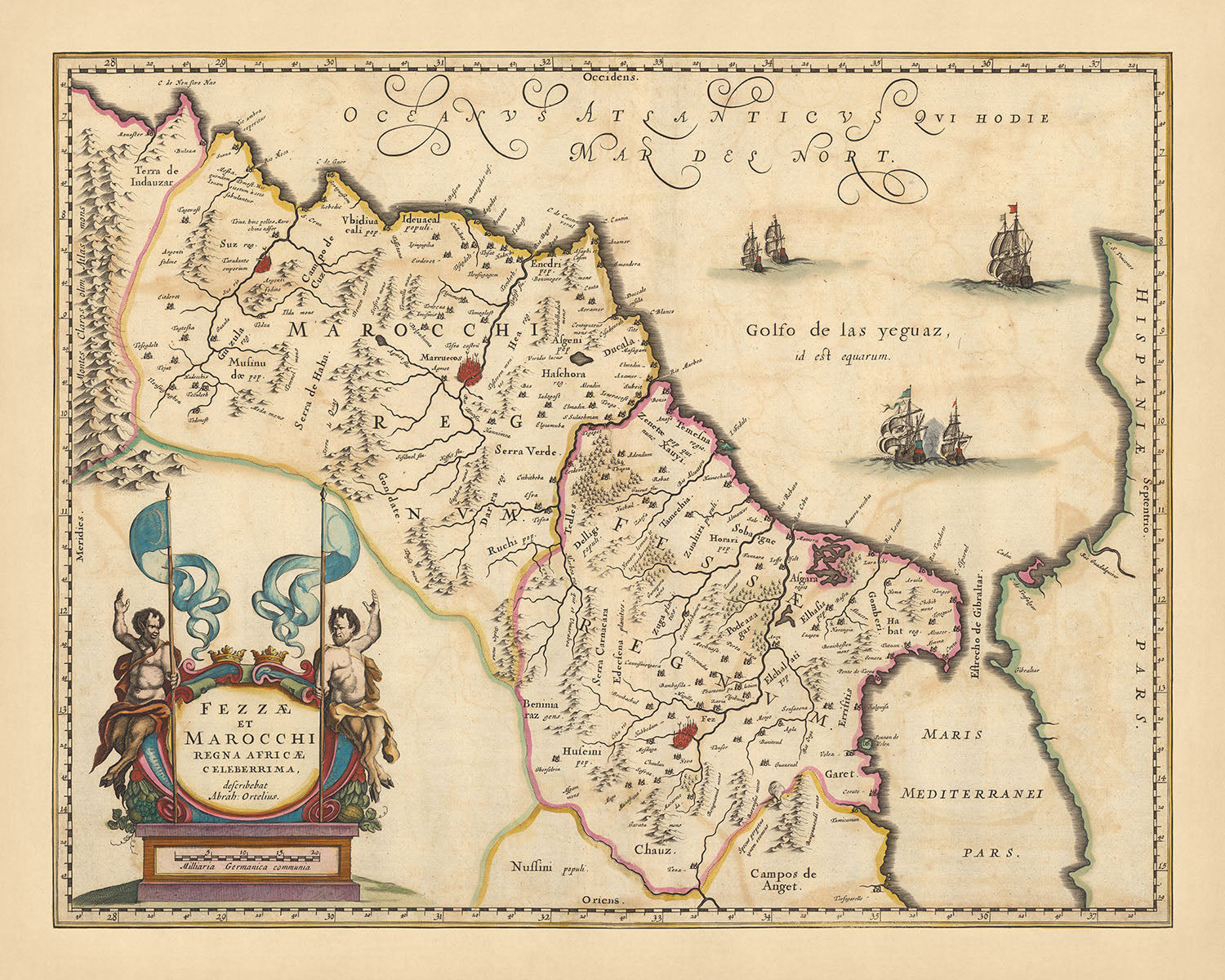

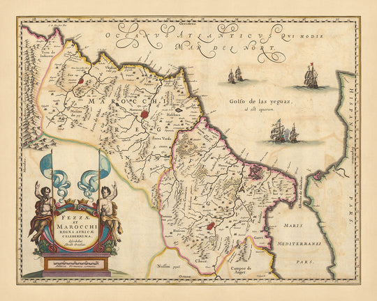


Old Map of Kingdoms of Fez & Marrakech, Morocco by Visscher, 1690: Rabat, Casablanca, Atlas Mountains

-
![]() Handmade in the UK (we're based in London)
Handmade in the UK (we're based in London)
-
FREE worldwide delivery in 2-3 days ⓘ
Free delivery in 2-3 days
Your map should be delivered in 2-3 working days with free delivery, worldwide.
We make maps by hand locally in 23 countries, including the UK
![]() . If you're buying a gift for someone in another country, we will make the map locally to them.
. If you're buying a gift for someone in another country, we will make the map locally to them.You will never pay import tax or customs duty.
Express delivery is available at checkout which can reduce the delivery time to 1-2 days.
Please note that personalised maps, and larger framed maps, can take longer to produce and deliver.
If you need your order to arrive by a certain date, contact me and we can discuss your options.
-
90 day money back guarantee
ⓘ
90 days to return and refund
Products can be returned within 90 days for a full refund, or exchange for another product.
For personalised or custom made items, we may offer you store credit or a non-expiring gift card, as we cannot resell personalised orders.
If you have any questions, get in touch. For more information, see our full returns & exchanges policy.

My maps are rare, museum-grade, restored old maps sourced from libraries, auction houses and private collections across the globe.
Framing & free personalisation available
1. Select your size
2. Frame & personalise your map
Make your map unique with framing, hand-drawn customisation, vintage ageing, pop art text, unique 3D styling and moreGift message & custom finish

If you want to add a gift message, or a finish (jigsaw, aluminium board, etc.) that is not available here, please request it in the "order note" when you check out.
Every order is custom made, so if you need the size adjusted slightly, or printed on an unusual material, just let us know. We've done thousands of custom orders over the years, so there's (almost) nothing we can't manage.
You can also contact us before you order, if you prefer!

- Handmade locally. No import duty or tax
- FREE Delivery. Arrives in 2-3 days
- Love it or your money back
- Questions? WhatsApp me any time
Own a piece of history
5,000+ 5 star reviews


Immerse yourself in the rich tapestry of history with the exquisite 'Fezzae et Marocchi regna Africae celeberrima, describebat Abrah' map, a masterful creation by the renowned mapmaker Nicolaes Visscher II. Translated into English, the title signifies 'The most celebrated kingdoms of Fez and Marrakech in Africa, described by Abraham'. This map, dating back to 1690, offers a detailed view of the regions of Fez and Marrakech, along with the larger area of Morocco, a land steeped in culture and history.
The map, with its meticulous details, captures the grandeur of significant cities such as Marrakech, Fes, Rabat, and Casablanca. Each city, with its unique history and culture, is depicted with remarkable precision, allowing you to traverse through time and space. The majestic Atlas Mountains, a geographical marvel, are also beautifully represented, adding a touch of nature's grandeur to the man-made boundaries.
The map is not just a representation of geographical locations but also a vivid depiction of the political landscape of the time. The clearly marked political boundaries provide a glimpse into the historical divisions and power dynamics that shaped the region. The inclusion of towns, waterways, and canals further adds to the intricate detailing, offering a comprehensive view of the region's topography.
The map is also embellished with a decorative title cartouche, adding an artistic touch to the scientific precision. The relief shown pictorially provides a sense of depth and realism, making the map not just a piece of historical artifact, but also a work of art. Wildlife and other landmarks are also depicted, adding layers of interest and intrigue. This map, with its blend of history, geography, and art, is a treasure trove for those with a keen interest in the past and a discerning eye for beauty.
Some of the significant locations shown on this map:
Kingdom of Fez:
- Fes - Founded in 789, Fes is one of the world's oldest inhabited cities and a former capital of Morocco. It's known for its vibrant souks and historic medina, a UNESCO World Heritage site.
- Taza - Established in 710, Taza is known for its strategic location between the Rif and Middle Atlas Mountains.
- Meknes - Founded in the 11th century, Meknes is one of Morocco's four imperial cities and was the capital during the reign of Sultan Moulay Ismail.
- Chefchaouen - Founded in 1471, Chefchaouen is famous for its blue-painted streets and buildings.
- Tetouan - Established in the 3rd century BC, Tetouan served as the main point of contact between Morocco and Andalusia.
- Ksar el-Kebir - Founded in the 8th century, it's known for the Battle of the Three Kings in 1578.
- Larache - Established in the 7th century BC, Larache is a coastal city known for its Spanish influence.
- Asilah - Founded in 1500 BC, Asilah is a fortified town on the northwest tip of the Atlantic coast.
- Safi - Established in the 11th century, Safi was a center for trade and navigation.
- Azemmour - Founded in the 2nd century BC, Azemmour is known for its historical medina.
- Sale - Established in 1030, Sale is known for its old medina and the Sale Rovers, a group of pirates who established a republic in the 17th century.
- Kenitra - Founded in the 9th century, Kenitra is known for its strategic location near the mouth of the Sebou River.
- Rabat - Founded in the 3rd century BC, Rabat is the current capital of Morocco and known for its cultural sites.
- Casablanca - Established in the 7th century BC, Casablanca is now Morocco's largest city and economic hub.
- Marrakech - Founded in 1062, Marrakech is known for its vibrant souks and historic sites.
Kingdom of Marrakech:
- Agadir - Founded in 1505, Agadir is known for its beautiful beaches and modern architecture.
- Essaouira - Established in the 7th century BC, Essaouira is a coastal city known for its well-preserved 18th-century medina.
- Taroudant - Founded in the 11th century, Taroudant is known for its historic city walls and souks.
- Ouarzazate - Established in 1928, Ouarzazate is known as a gateway to the Sahara Desert.
- Zagora - Founded in the 13th century, Zagora is known for its proximity to the Draa River valley.
- Tinghir - Established in the 13th century, Tinghir is known for its stunning Todra Gorge.
- Errachidia - Founded in 691, Errachidia is known for its Ziz River and palm groves.
- Midelt - Established in 1670, Midelt is known for its apple orchards and beautiful mountainous surroundings.
- Beni Mellal - Founded in 1688, Beni Mellal is known for its strategic location in the middle of Morocco.
- Khouribga - Established in 1923, Khouribga is known for its phosphate mining.
- Settat - Founded in 1524, Settat is known for its historic medina and Chaouia culture.
- El Jadida - Established in 1502, El Jadida is a port city known for its Portuguese Fortified City of Mazagan.
- Safi - Founded in the 11th century, Safi is known for its pottery and historic medina.
- Marrakech - Founded in 1062, Marrakeck is known for its vibrant souks and historic sites.
- Fes - Founded in 789, Fes is one of the world's oldest inhabited cities and a former capital of Morocco.
Notable natural phenomena and tourist attractions:
- Atlas Mountains - A mountain range across a northern stretch of Africa extending about 2,500 km.
- Rif Mountains - A mountain range in Northern Morocco.
- Sahara Desert - The world's largest hot desert.
- Draa River - Morocco's longest river.
- Ziz River - A well-known river in Morocco, especially noted for its spectacular gorges.
Notable historical events in this region between 1600 and 1690:
- Battle of Ksar El Kebir (1578) - A significant battle in Moroccan history, also known as the Battle of the Three Kings.
- Establishment of the Alaouite Dynasty (1631) - The current Moroccan royal family, under the leadership of Sharif ibn Ali.
- Barbary Pirates (1600s) - The Sale Rovers were infamous during this period, establishing a pirate republic in Sale.
Please double check the images to make sure that a specific town or place is shown on this map. You can also get in touch and ask us to check the map for you.
This map looks great at all sizes: 12x16in (30.5x41cm), 16x20in (40.5x51cm), 18x24in (45.5x61cm), 24x30in (61x76cm), 32x40in (81.5x102cm), 40x50in (102x127cm), 48x60in (122x153cm) and 56x70in (142x178cm), but it looks even better when printed large.
I can create beautiful, large prints of this map up to 90in (229cm). Please get in touch if you're looking for larger, customised or different framing options.
The model in the listing images is holding the 16x20in (40.5x51cm) version of this map.
The fifth listing image shows an example of my map personalisation service.
If you’re looking for something slightly different, check out my collection of the best old maps of Europe and European cities to see if something else catches your eye.
Please contact me to check if a certain location, landmark or feature is shown on this map.
This would make a wonderful birthday, Christmas, Father's Day, work leaving, anniversary or housewarming gift for someone from the areas covered by this map.
This map is available as a giclée print on acid free archival matte paper, or you can buy it framed. The frame is a nice, simple black frame that suits most aesthetics. Please get in touch if you'd like a different frame colour or material. My frames are glazed with super-clear museum-grade acrylic (perspex/acrylite), which is significantly less reflective than glass, safer, and will always arrive in perfect condition.
This map is also available as a float framed canvas, sometimes known as a shadow gap framed canvas or canvas floater. The map is printed on artist's cotton canvas and then stretched over a handmade box frame. We then "float" the canvas inside a wooden frame, which is available in a range of colours (black, dark brown, oak, antique gold and white). This is a wonderful way to present a map without glazing in front. See some examples of float framed canvas maps and explore the differences between my different finishes.
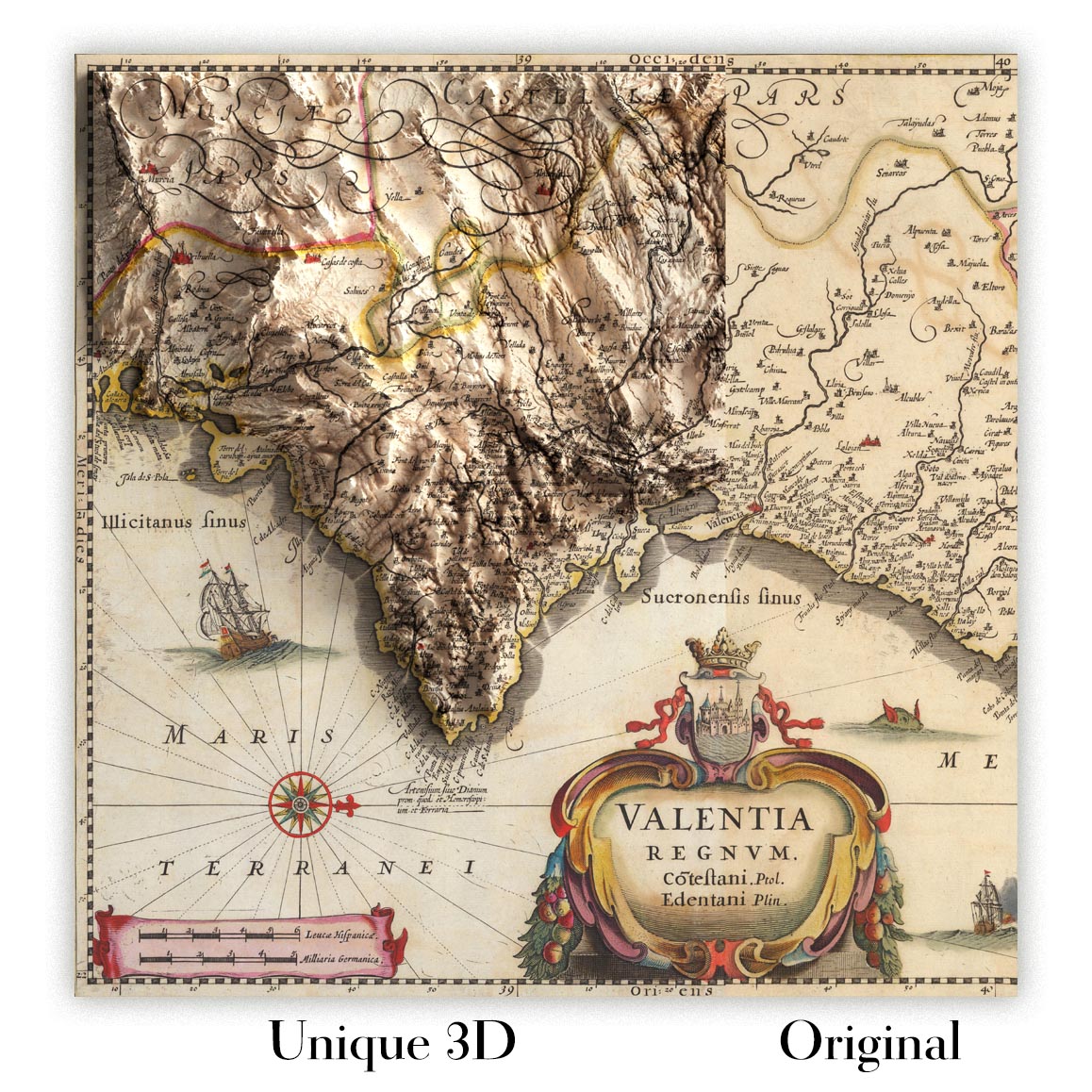
For something truly unique, this map is also available in "Unique 3D", our trademarked process that dramatically transforms the map so that it has a wonderful sense of depth. We combine the original map with detailed topography and elevation data, so that mountains and the terrain really "pop". For more info and examples of 3D maps, check my Unique 3D page.
For most orders, delivery time is about 3 working days. Personalised and customised products take longer, as I have to do the personalisation and send it to you for approval, which usually takes 1 or 2 days.
Please note that very large framed orders usually take longer to make and deliver.
If you need your order to arrive by a certain date, please contact me before you order so that we can find the best way of making sure you get your order in time.
I print and frame maps and artwork in 23 countries around the world. This means your order will be made locally, which cuts down on delivery time and ensures that it won't be damaged during delivery. You'll never pay customs or import duty, and we'll put less CO2 into the air.
All of my maps and art prints are well packaged and sent in a rugged tube if unframed, or surrounded by foam if framed.
I try to send out all orders within 1 or 2 days of receiving your order, though some products (like face masks, mugs and tote bags) can take longer to make.
If you select Express Delivery at checkout your order we will prioritise your order and send it out by 1-day courier (Fedex, DHL, UPS, Parcelforce).
Next Day delivery is also available in some countries (US, UK, Singapore, UAE) but please try to order early in the day so that we can get it sent out on time.
My standard frame is a gallery style black ash hardwood frame. It is simple and quite modern looking. My standard frame is around 20mm (0.8in) wide.
I use super-clear acrylic (perspex/acrylite) for the frame glass. It's lighter and safer than glass - and it looks better, as the reflectivity is lower.
Six standard frame colours are available for free (black, dark brown, dark grey, oak, white and antique gold). Custom framing and mounting/matting is available if you're looking for something else.
Most maps, art and illustrations are also available as a framed canvas. We use matte (not shiny) cotton canvas, stretch it over a sustainably sourced box wood frame, and then 'float' the piece within a wood frame. The end result is quite beautiful, and there's no glazing to get in the way.
All frames are provided "ready to hang", with either a string or brackets on the back. Very large frames will have heavy duty hanging plates and/or a mounting baton. If you have any questions, please get in touch.
See some examples of my framed maps and framed canvas maps.
Alternatively, I can also supply old maps and artwork on canvas, foam board, cotton rag and other materials.
If you want to frame your map or artwork yourself, please read my size guide first.
My maps are extremely high quality reproductions of original maps.
I source original, rare maps from libraries, auction houses and private collections around the world, restore them at my London workshop, and then use specialist giclée inks and printers to create beautiful maps that look even better than the original.
My maps are printed on acid-free archival matte (not glossy) paper that feels very high quality and almost like card. In technical terms the paper weight/thickness is 10mil/200gsm. It's perfect for framing.
I print with Epson ultrachrome giclée UV fade resistant pigment inks - some of the best inks you can find.
I can also make maps on canvas, cotton rag and other exotic materials.
Learn more about The Unique Maps Co.
Map personalisation
If you're looking for the perfect anniversary or housewarming gift, I can personalise your map to make it truly unique. For example, I can add a short message, or highlight an important location, or add your family's coat of arms.
The options are almost infinite. Please see my map personalisation page for some wonderful examples of what's possible.
To order a personalised map, select "personalise your map" before adding it to your basket.
Get in touch if you're looking for more complex customisations and personalisations.
Map ageing
I have been asked hundreds of times over the years by customers if they could buy a map that looks even older.
Well, now you can, by selecting Aged before you add a map to your basket.
All the product photos you see on this page show the map in its Original form. This is what the map looks like today.
If you select Aged, I will age your map by hand, using a special and unique process developed through years of studying old maps, talking to researchers to understand the chemistry of aging paper, and of course... lots of practice!
If you're unsure, stick to the Original colour of the map. If you want something a bit darker and older looking, go for Aged.
If you are not happy with your order for any reason, contact me for a no-quibble refund. Please see our returns and refund policy for more information.
I am very confident you will like your restored map or art print. I have been doing this since 1984. I'm a 5-star Etsy seller. I have sold tens of thousands of maps and art prints and have over 5,000 real 5-star reviews.
I use a unique process to restore maps and artwork that is massively time consuming and labour intensive. Hunting down the original maps and illustrations can take months. I use state of the art and eye-wateringly expensive technology to scan and restore them. As a result, I guarantee my maps and art prints are a cut above the rest - that's why I can offer a no-quibble refund.
Almost all of my maps and art prints look amazing at large sizes (200cm, 6.5ft+) and I can frame and deliver them to you as well, via special oversized courier. Contact me to discuss your specific needs.
Or try searching for something!


