


Old Map of "Italy: the Newest Empire" by Sundberg, 1939: WW2, Mussolin, Vs. Roman Empire
Buy 2, Get 1 Free
If you add 2 items to your bag, you can add a third product for free. The discount is automatic - no code required.
This is equivalent to 33% off, which will be the largest discount available on my shop this year.
This works for all maps and artwork. You can order 3 of the same thing, or 3 different things.
My custom maps are excluded, as they're too time consuming to make and we'd prefer to take our time rather than rush through a lot of orders.
Please take advantage of the deal and buy lots of beautiful maps and art for your walls.
Contact me if you have any questions.

-
![]() Handmade in the UK (we're based in London)
Handmade in the UK (we're based in London)
-
FREE worldwide delivery in 2-3 days ⓘ
Free delivery in 2-3 days
Your map should be delivered in 2-3 working days with free delivery, worldwide.
Deliveries over the Christmas and New Year period may be slightly delayed, as couriers and postal services catch up with a huge backlog of packages.
We make maps by hand locally in 23 countries, including the UK
![]() . If you're buying a gift for someone in another country, we will make the map locally to them.
. If you're buying a gift for someone in another country, we will make the map locally to them.You will never pay import tax or customs duty.
Express delivery is available at checkout which can reduce the delivery time to 1-2 days.
Please note that personalised maps, and larger framed maps, can take longer to produce and deliver.
If you need your order to arrive by a certain date, contact me and we can discuss your options.
-
FREE gift preview
ⓘ
Digital gift preview
After you complete your order, you can send a beautiful digital preview to the gift recipient. Just provide their email address and we'll do the rest. (Their email address will not be stored or used for any other purpose.)
This is perfect if you're concerned that your order might not arrive in time.
You can also buy a real non-expiring gift card, and email it directly to the recipient, so they can buy their own map or artwork.
-
90 day money back guarantee
ⓘ
90 days to return and refund
Products can be returned within 90 days for a full refund, or exchange for another product.
For personalised and custom made items, we may offer you store credit or a non-expiring gift card, as we cannot resell personalised orders.
If you have any questions, get in touch. For more information, see our full returns & exchanges policy.

My maps are rare, museum-grade, restored old maps sourced from libraries, auction houses and private collections across the globe.
Framing & free personalisation available
1. Select your size
Click here to order a custom size.
2. Frame & personalise your map
Make your map unique with framing, hand-drawn customisation, vintage ageing, pop art text, unique 3D styling and more.


Gift message & custom finish

If you want to add a gift message, or a finish (jigsaw, aluminium board, etc.) that is not available here, please request it in the "order note" when you check out.
Every order is custom made, so if you need the size adjusted slightly, or printed on an unusual material, just let us know. We've done thousands of custom orders over the years, so there's (almost) nothing we can't manage.
You can also contact us before you order, if you prefer!

- Handmade locally. No import duty or tax
- FREE worldwide delivery
- Love it or your money back (90 days)
- Questions? WhatsApp me any time
Own a piece of history
5,000+ 5 star reviews


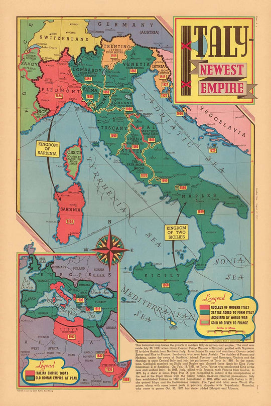
Step into a pivotal moment in world history with “Italy – Newest Empire,” a captivating pictorial map crafted by Edwin L. Sundberg and published on August 27, 1939. Created just days before the outbreak of World War II, this map offers a visually rich and thematically charged exploration of Italy’s imperial ambitions under Benito Mussolini’s fascist regime. Sundberg, renowned for his ability to translate complex geopolitical realities into accessible art, uses vibrant color and intricate illustration to capture both the grandeur and the tension of the era. This map is not only a testament to Italy’s aspirations but also a window into the anxieties and ambitions that shaped Europe on the eve of global conflict.
Intriguingly, an inset map compares Mussolini's new Italian empire to the old Roman Empire.
The map’s artistry is immediately apparent, blending cartographic precision with evocative pictorial elements. Italy sits at the center, surrounded by its Mediterranean neighbors and highlighted colonies in Africa—Libya, Eritrea, and Italian Somaliland—reflecting the country’s aggressive expansionist policies. Major cities such as Rome, Milan, Venice, and Naples are clearly marked, while the Mediterranean and Adriatic Seas are depicted as strategic theaters for Italian power. Sundberg’s use of military symbols, iconic landmarks, and imperial motifs brings to life the fervor of Italian nationalism and the propaganda of the time, making this map a unique artifact of both information and persuasion.
Historically, this map is invaluable for understanding the mindset and motivations that propelled Italy into the Second World War. It visually narrates the transformation of Italy from a regional power to an empire with overseas territories, illustrating routes of conquest and the integration of newly acquired lands like Ethiopia (then known as Abyssinia) into Italian East Africa. The map also places Italy in context with neighboring nations—France, Switzerland, Austria, and Yugoslavia—emphasizing the country’s centrality and the potential flashpoints that would soon ignite the continent. Each detail is a reminder of the precarious balance of power and the role of cartography in shaping public perception.
Beyond its political and military significance, “Italy – Newest Empire” is a masterclass in the art of thematic mapping. Sundberg’s decorative flourishes—classical motifs, banners, and vignettes—evoke the grandeur of ancient Rome while underscoring the modern ambitions of the fascist state. The map’s careful delineation of borders, strategic ports like Genoa and Taranto, and enclaves such as Vatican City and San Marino, reflect a nuanced understanding of Italy’s geography and its cultural complexity. The result is a map that is as informative as it is visually arresting, offering layers of meaning for historians, collectors, and enthusiasts alike.
Owning this map is akin to possessing a piece of living history—a document that encapsulates the hopes, fears, and realities of a world on the brink of war. Whether displayed as a centerpiece in a study or admired for its artistic merit, “Italy – Newest Empire” invites reflection on the forces that have shaped our modern world. It stands as both a cautionary tale and a celebration of the enduring power of maps to capture the spirit of an age.
Places on this map
- Rome
- Milan
- Venice
- Naples
- Florence
- Genoa
- Turin
- Trieste
- Taranto
- Palermo
- Cagliari (Sardinia)
- Addis Ababa (Ethiopia, Italian East Africa)
- Tripoli (Libya)
- Asmara (Eritrea)
- Mogadishu (Italian Somaliland)
- Rhodes (Dodecanese Islands)
- Vatican City
- San Marino
- Sicily
- Sardinia
Notable Features & Landmarks
- Italy prominently depicted at the center, emphasizing its central role in the map’s narrative
- Italian territories and colonies in Africa, such as Libya, Eritrea, and Italian Somaliland, are highlighted
- The island of Sicily and Sardinia are clearly marked
- Neighboring countries such as France, Switzerland, Austria, and Yugoslavia are shown for context
- The Mediterranean Sea is labeled and illustrated as a strategic area for Italian ambitions
- Major Italian cities such as Rome, Milan, Venice, Naples, and Florence are labeled
- Routes of expansion or conquest are indicated, possibly with arrows or lines
- Areas of recent or ongoing conflict, such as Ethiopia (Abyssinia), are depicted as part of the Italian empire
- Borders of Italian possessions are marked with bold lines or color differentiation
- The Alps and mountainous regions are illustrated to show natural boundaries
- The Suez Canal and its strategic importance are indicated
- Key battle sites or areas of recent military action are labeled
- Artistic embellishments such as decorative cartouches or banners with the map’s title
- The Adriatic Sea is labeled, emphasizing Italy’s eastern maritime interests
- The Dodecanese Islands (then under Italian control) are shown
- Italian East Africa, formed from conquered Ethiopian territory, is marked
- Illustrations of Italian aircraft or air routes may be present
- The map uses color to differentiate Italian lands from neighboring countries
- Notations or legends explaining symbols and colors used on the map
- The Vatican City and San Marino are shown as independent enclaves within Italy
- The map may include a timeline or dates of major events
- The map’s artistic border may feature classical Italian motifs
- Important ports such as Genoa, Trieste, and Taranto are labeled
- The map’s artistic style conveys a sense of dynamism and expansion
Historical and design context
- Name of the map: Italy - Newest Empire. August 27, 1939.
- Date created: August 27, 1939, shortly before the outbreak of World War II
- Mapmaker/publisher: Edwin L. Sundberg, a staff artist for the Sunday News
- The map is a pictorial and thematic map, rich in color and illustration, designed to be both informative and visually engaging
- Created at a time when Italy, under Benito Mussolini's fascist regime, was pursuing aggressive expansionist policies and imperial ambitions in Europe and Africa
- Highlights the extent of Italy’s territorial ambitions and recent conquests, reflecting Italian nationalism and imperialism on the eve of World War II
- Provides insight into Italy’s role and aspirations on the world stage, just days before the start of WWII
- Shows Italian colonies in Africa (such as Libya, Eritrea, and Italian Somaliland) and other territorial claims
- Serves as both an informative piece and a subtle commentary on the ambitions and propaganda of the Italian fascist regime
- Combines factual geographic information with artistic embellishments, typical of 1930s pictorial maps
- Captures a moment in pre-WWII history, illustrating the expansionist mindset that contributed to the outbreak of global conflict
- Edwin L. Sundberg was known for creating visually striking and informative maps and illustrations for newspapers, making complex international events accessible to the public
- Maps like this influenced how American readers understood the rapidly changing political landscape in Europe and Africa
- The map’s date coincides with the final days before WWII, highlighting Italy’s alliances and strategic interests
- Reflects widespread concerns about the stability of Europe and the ambitions of totalitarian states
- Today, the map is a valuable artifact for historians studying public opinion, media, and international relations in the late 1930s
Please double check the images to make sure that a specific town or place is shown on this map. You can also get in touch and ask us to check the map for you.
This map looks great at every size, but I always recommend going for a larger size if you have space. That way you can easily make out all of the details.
This map looks amazing at sizes all the way up to 70in (180cm). If you are looking for a larger map, please get in touch.
The model in the listing images is holding the 24x36in (60x90cm) version of this map.
The fifth listing image shows an example of my map personalisation service.
If you’re looking for something slightly different, check out my collection of the best old maps to see if something else catches your eye.
Please contact me to check if a certain location, landmark or feature is shown on this map.
This would make a wonderful birthday, Christmas, Father's Day, work leaving, anniversary or housewarming gift for someone from the areas covered by this map.
This map is available as a giclée print on acid free archival matte paper, or you can buy it framed. The frame is a nice, simple black frame that suits most aesthetics. Please get in touch if you'd like a different frame colour or material. My frames are glazed with super-clear museum-grade acrylic (perspex/acrylite), which is significantly less reflective than glass, safer, and will always arrive in perfect condition.
This map is also available as a float framed canvas, sometimes known as a shadow gap framed canvas or canvas floater. The map is printed on artist's cotton canvas and then stretched over a handmade box frame. We then "float" the canvas inside a wooden frame, which is available in a range of colours (black, dark brown, oak, antique gold and white). This is a wonderful way to present a map without glazing in front. See some examples of float framed canvas maps and explore the differences between my different finishes.
For something truly unique, this map is also available in "Unique 3D", our trademarked process that dramatically transforms the map so that it has a wonderful sense of depth. We combine the original map with detailed topography and elevation data, so that mountains and the terrain really "pop". For more info and examples of 3D maps, check my Unique 3D page.
For most orders, delivery time is about 3 working days. Personalised and customised products take longer, as I have to do the personalisation and send it to you for approval, which usually takes 1 or 2 days.
Please note that very large framed orders usually take longer to make and deliver.
If you need your order to arrive by a certain date, please contact me before you order so that we can find the best way of making sure you get your order in time.
I print and frame maps and artwork in 23 countries around the world. This means your order will be made locally, which cuts down on delivery time and ensures that it won't be damaged during delivery. You'll never pay customs or import duty, and we'll put less CO2 into the air.
All of my maps and art prints are well packaged and sent in a rugged tube if unframed, or surrounded by foam if framed.
I try to send out all orders within 1 or 2 days of receiving your order, though some products (like face masks, mugs and tote bags) can take longer to make.
If you select Express Delivery at checkout your order we will prioritise your order and send it out by 1-day courier (Fedex, DHL, UPS, Parcelforce).
Next Day delivery is also available in some countries (US, UK, Singapore, UAE) but please try to order early in the day so that we can get it sent out on time.
My standard frame is a gallery style black ash hardwood frame. It is simple and quite modern looking. My standard frame is around 20mm (0.8in) wide.
I use super-clear acrylic (perspex/acrylite) for the frame glass. It's lighter and safer than glass - and it looks better, as the reflectivity is lower.
Six standard frame colours are available for free (black, dark brown, dark grey, oak, white and antique gold). Custom framing and mounting/matting is available if you're looking for something else.
Most maps, art and illustrations are also available as a framed canvas. We use matte (not shiny) cotton canvas, stretch it over a sustainably sourced box wood frame, and then 'float' the piece within a wood frame. The end result is quite beautiful, and there's no glazing to get in the way.
All frames are provided "ready to hang", with either a string or brackets on the back. Very large frames will have heavy duty hanging plates and/or a mounting baton. If you have any questions, please get in touch.
See some examples of my framed maps and framed canvas maps.
Alternatively, I can also supply old maps and artwork on canvas, foam board, cotton rag and other materials.
If you want to frame your map or artwork yourself, please read my size guide first.
My maps are extremely high quality reproductions of original maps.
I source original, rare maps from libraries, auction houses and private collections around the world, restore them at my London workshop, and then use specialist giclée inks and printers to create beautiful maps that look even better than the original.
My maps are printed on acid-free archival matte (not glossy) paper that feels very high quality and almost like card. In technical terms the paper weight/thickness is 10mil/200gsm. It's perfect for framing.
I print with Epson ultrachrome giclée UV fade resistant pigment inks - some of the best inks you can find.
I can also make maps on canvas, cotton rag and other exotic materials.
Learn more about The Unique Maps Co.
Map personalisation
If you're looking for the perfect anniversary or housewarming gift, I can personalise your map to make it truly unique. For example, I can add a short message, or highlight an important location, or add your family's coat of arms.
The options are almost infinite. Please see my map personalisation page for some wonderful examples of what's possible.
To order a personalised map, select "personalise your map" before adding it to your basket.
Get in touch if you're looking for more complex customisations and personalisations.
Map ageing
I have been asked hundreds of times over the years by customers if they could buy a map that looks even older.
Well, now you can, by selecting Aged before you add a map to your basket.
All the product photos you see on this page show the map in its Original form. This is what the map looks like today.
If you select Aged, I will age your map by hand, using a special and unique process developed through years of studying old maps, talking to researchers to understand the chemistry of aging paper, and of course... lots of practice!
If you're unsure, stick to the Original colour of the map. If you want something a bit darker and older looking, go for Aged.
If you are not happy with your order for any reason, contact me and I'll get it fixed ASAP, free of charge. Please see my returns and refund policy for more information.
I am very confident you will like your restored map or art print. I have been doing this since 1984. I'm a 5-star Etsy seller. I have sold tens of thousands of maps and art prints and have over 5,000 real 5-star reviews. My work has been featured in interior design magazines, on the BBC, and on the walls of dozens of 5-star hotels.
I use a unique process to restore maps and artwork that is massively time consuming and labour intensive. Hunting down the original maps and illustrations can take months. I use state of the art and eye-wateringly expensive technology to scan and restore them. As a result, I guarantee my maps and art prints are a cut above the rest. I stand by my products and will always make sure you're 100% happy with what you receive.
Almost all of my maps and art prints look amazing at large sizes (200cm, 6.5ft+) and I can frame and deliver them to you as well, via special oversized courier. Contact me to discuss your specific needs.
Or try searching for something!


