


Old Channels between Asinara and Sardinia Nautical Chart by Heather, 1802: Cape Azinara, Castelsardo, Secca di Mezzo
Buy 2, Get 1 More Free
If you add 2 items to your bag, you can add a third product for free. The discount is automatic - no code required.
This is equivalent to 33% off, which will be the largest discount available on my shop this year.
This works for all maps and artwork. You can order 3 of the same thing, or 3 different things.
Custom maps are excluded, as they're too time consuming to make and we'd prefer to take our time rather than rush through a lot of orders.
Contact me if you have any questions.
-
![]() Handmade in the UK (we're based in London)
Handmade in the UK (we're based in London)

-
FREE worldwide delivery in 2-3 days ⓘ
Free delivery in 2-3 days
Your map should be delivered in 2-3 working days with free delivery, worldwide.
We make maps by hand locally in 23 countries, including the UK
![]() . If you're buying a gift for someone in another country, we will make the map locally to them.
. If you're buying a gift for someone in another country, we will make the map locally to them.You will never pay import tax or customs duty.
Express delivery is available at checkout which can reduce the delivery time to 1-2 days.
Please note that personalised maps, and larger framed maps, can take longer to produce and deliver.
If you need your order to arrive by a certain date, contact me and we can discuss your options.
-
Complimentary gifting & design advice
ⓘ
Complimentary gifting & design advice
Available almost 24/7 on WhatsApp and email — we usually reply within minutes. We can help you:
- Choose a perfectly personalised gift
- Send a digital gift preview to the recipient
- Pick the ideal size for your wall
- Select the right finish and frame
Quick, friendly advice so you can order with confidence.
For last minute gifts, consider buying a digital gift card. We have over 5,000 maps and art prints to choose from.
-
90-day returns & 5-year guarantee
ⓘ
90-day returns & 5-year guarantee
Products can be returned within 90 days for a full refund, or exchange for another product.
We are also proud to offer a 5-year quality guarantee on our maps and art, covering defects in materials or workmanship under normal use.
For personalised and custom made items, we may offer you store credit or a non-expiring gift card, as we cannot resell personalised orders.
If you have any questions, get in touch. For more information, see our full returns & exchanges policy.

This is a museum-grade archival print from the original 1802 map — restored in our workshop and made to order on 220gsm archival matte paper or 400gsm artist's cotton canvas with pigment inks.
Professional framing & free personalisation available
1. Choose a size
2. Frame & personalise your map
Make your map unique with framing, hand-drawn customisation, vintage ageing, pop art text, unique 3D styling and more.


Gift message & custom finish

If you want to add a gift message, or a finish (jigsaw, aluminium board, etc.) that is not available here, please request it in the "order note" when you check out.
Every order is custom made, so if you need the size adjusted slightly, or printed on an unusual material, just let us know. We've done thousands of custom orders over the years, so there's (almost) nothing we can't manage.
You can also contact us before you order, if you prefer!

- Handmade locally. No import duty or tax
- FREE worldwide delivery
- 90-day returns & 5-year product guarantee
- Questions? WhatsApp me any time
Own a piece of history
7,000+ 5 star reviews


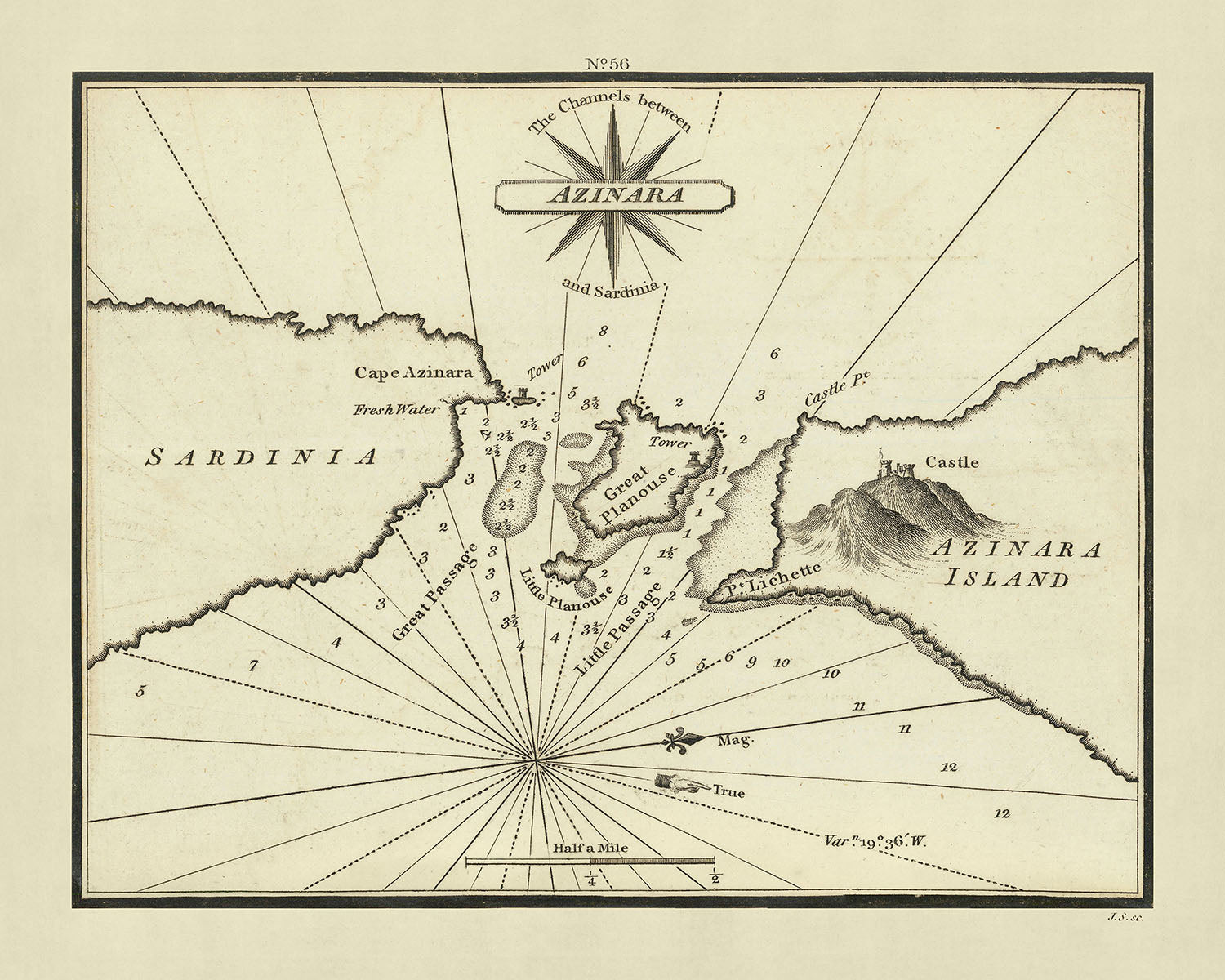
Exploring the Nautical Chart: "The Channels between Azinara and Sardinia"
Dive into the intricacies of maritime navigation with the exquisite 1802 nautical chart, "The Channels between Azinara and Sardinia," crafted by the esteemed British hydrographer William Heather. This chart is not merely a navigational tool but a piece of history, capturing the essence of early 19th-century seafaring. Heather, renowned for his detailed and precise maritime charts, presents a meticulous depiction of the waterways separating the rugged island of Asinara from the majestic shores of Sardinia. The map’s orientation with west at the top and its inclusion of soundings, anchorages, and topographical nuances make it a fascinating study for enthusiasts of maritime history and cartography alike.
Navigational Details and Topographical Features
Heather's chart is a treasure trove of information, detailing the underwater and coastal geography critical for sailors of the time. It includes soundings - measurements of water depth crucial for safe navigation - which are meticulously noted throughout the channels. The chart also marks significant maritime landmarks such as Cape Azinara, the Great and Little Planouse, and various shoals like Secca di Mezzo, Secca di Fuori, and Secca di Dentro, which pose navigational challenges. These features not only aided navigators but now serve as a window into the geographical knowledge and challenges faced by mariners of the 19th century.
Cartographic Rarity and Historical Significance
The rarity of "The Channels between Azinara and Sardinia" adds to its allure. As part of Heather's "New Mediterranean Pilot," this chart represents a rare artifact seldom seen on the market, making it a prized possession for collectors and historians. Published during a period of intense European maritime exploration and naval power, this chart is not just a navigational aid but a historical document that offers insights into the era's maritime strategies, trade routes, and the evolution of nautical chart-making.
Strategic Maritime Locations
This chart is particularly valuable for its strategic depiction of notable locations along the Sardinian and Asinara coastlines. It marks the positions of key navigational points such as the town of Castelsardo, known for its historical significance and picturesque castle, and smaller islands like Isola Piana and Isola dei Porri. These annotations provide a deeper understanding of the area's maritime importance, both from a commercial and military standpoint during a time when Mediterranean dominance was crucial to European powers.
A Collector's Dream and a Historian's Treasure
For collectors, owning a chart like "The Channels between Azinara and Sardinia" is akin to possessing a rare gem. For historians and scholars, it offers an empirical glimpse into the cartographic and navigational practices of the early 1800s, reflecting the meticulous work of William Heather and his contribution to the science of hydrography. This chart is not only a navigational piece but also an artistic representation of maritime geography, rendered with the precision and skill that only a master like Heather could achieve.
Notable Places on This Map
- Cape Azinara
- Great Planouse
- Little Planouse
- Pt Lichette
- Fresh Water
- Tower
- Castle Pt
- Castle
- Green Passage
- Sardinia
- Azinara Island
Notable Features & Landmarks
- The map shows the channels between Asinara and Sardinia, two islands in the Mediterranean Sea.
- The map is a nautical chart, showing coastal features, water depths, and navigational aids.
- The map shows the location of Cape Azinara, a headland on the northern coast of Sardinia.
- The map shows the location of the town of Castelsardo, on the northern coast of Sardinia.
- The map shows the location of the Isola Piana, a small island off the coast of Sardinia.
- The map shows the location of the Isola dei Porri, a small island off the coast of Sardinia.
- The map shows the location of the Secca di Mezzo, a shoal in the channel between Asinara and Sardinia.
- The map shows the location of the Secca di Fuori, a shoal in the channel between Asinara and Sardinia.
- The map shows the location of the Secca di Dentro, a shoal in the channel between Asinara and Sardinia.
Historical and Design Context
- Title: The Channels between Azinara and Sardinia
- Date: 1802
- Mapmaker/publisher: William Heather. Heather was a British hydrographer and publisher who produced a number of charts and books on navigation in the late 18th and early 19th centuries.
- Topics and themes: The map shows the channels between the island of Asinara and Sardinia, including soundings, some topographical features and anchorages.
- Countries and regions: The map shows the island of Asinara, Sardinia, and the surrounding area.
- Design or style: The map is a detailed and accurate representation of the area, and it is an important example of Heather's work.
- Historical significance: The map was published during a time of great interest in exploration and navigation, and it is a valuable historical document that provides a glimpse into the world of seafaring in the early 19th century.
Please double check the images to make sure that a specific town or place is shown on this map. You can also get in touch and ask us to check the map for you.
This map looks great at every size, but I always recommend going for a larger size if you have space. That way you can easily make out all of the details.
This map looks amazing at sizes all the way up to 50in (125cm). If you are looking for a larger map, please get in touch.
The model in the listing images is holding the 16x20in (40x50cm) version of this map.
The fifth listing image shows an example of my map personalisation service.
If you’re looking for something slightly different, check out my collection of the best old maps to see if something else catches your eye.
Please contact me to check if a certain location, landmark or feature is shown on this map.
This would make a wonderful birthday, Christmas, Father's Day, work leaving, anniversary or housewarming gift for someone from the areas covered by this map.
This map is available as a giclée print on acid free archival matte paper, or you can buy it framed. The frame is a nice, simple black frame that suits most aesthetics. Please get in touch if you'd like a different frame colour or material. My frames are glazed with super-clear museum-grade acrylic (perspex/acrylite), which is significantly less reflective than glass, safer, and will always arrive in perfect condition.
This map is also available as a float framed canvas, sometimes known as a shadow gap framed canvas or canvas floater. The map is printed on artist's cotton canvas and then stretched over a handmade box frame. We then "float" the canvas inside a wooden frame, which is available in a range of colours (black, dark brown, oak, antique gold and white). This is a wonderful way to present a map without glazing in front. See some examples of float framed canvas maps and explore the differences between my different finishes.
For something truly unique, this map is also available in "Unique 3D", our trademarked process that dramatically transforms the map so that it has a wonderful sense of depth. We combine the original map with detailed topography and elevation data, so that mountains and the terrain really "pop". For more info and examples of 3D maps, check my Unique 3D page.
For most orders, delivery time is about 3 working days. Personalised and customised products take longer, as I have to do the personalisation and send it to you for approval, which usually takes 1 or 2 days.
Please note that very large framed orders usually take longer to make and deliver.
If you need your order to arrive by a certain date, please contact me before you order so that we can find the best way of making sure you get your order in time.
I print and frame maps and artwork in 23 countries around the world. This means your order will be made locally, which cuts down on delivery time and ensures that it won't be damaged during delivery. You'll never pay customs or import duty, and we'll put less CO2 into the air.
All of my maps and art prints are well packaged and sent in a rugged tube if unframed, or surrounded by foam if framed.
I try to send out all orders within 1 or 2 days of receiving your order, though some products (like face masks, mugs and tote bags) can take longer to make.
If you select Express Delivery at checkout your order we will prioritise your order and send it out by 1-day courier (Fedex, DHL, UPS, Parcelforce).
Next Day delivery is also available in some countries (US, UK, Singapore, UAE) but please try to order early in the day so that we can get it sent out on time.
My standard frame is a gallery style black ash hardwood frame. It is simple and quite modern looking. My standard frame is around 20mm (0.8in) wide.
I use super-clear acrylic (perspex/acrylite) for the frame glass. It's lighter and safer than glass - and it looks better, as the reflectivity is lower.
Six standard frame colours are available for free (black, dark brown, dark grey, oak, white and antique gold). Custom framing and mounting/matting is available if you're looking for something else.
Most maps, art and illustrations are also available as a framed canvas. We use matte (not shiny) cotton canvas, stretch it over a sustainably sourced box wood frame, and then 'float' the piece within a wood frame. The end result is quite beautiful, and there's no glazing to get in the way.
All frames are provided "ready to hang", with either a string or brackets on the back. Very large frames will have heavy duty hanging plates and/or a mounting baton. If you have any questions, please get in touch.
See some examples of my framed maps and framed canvas maps.
Alternatively, I can also supply old maps and artwork on canvas, foam board, cotton rag and other materials.
If you want to frame your map or artwork yourself, please read my size guide first.
My maps are extremely high quality reproductions of original maps.
I source original, rare maps from libraries, auction houses and private collections around the world, restore them at my London workshop, and then use specialist giclée inks and printers to create beautiful maps that look even better than the original.
My maps are printed on acid-free archival matte (not glossy) paper that feels very high quality and almost like card. In technical terms the paper weight/thickness is 10mil/200gsm. It's perfect for framing.
I print with Epson ultrachrome giclée UV fade resistant pigment inks - some of the best inks you can find.
I can also make maps on canvas, cotton rag and other exotic materials.
Learn more about The Unique Maps Co.
Map personalisation
If you're looking for the perfect anniversary or housewarming gift, I can personalise your map to make it truly unique. For example, I can add a short message, or highlight an important location, or add your family's coat of arms.
The options are almost infinite. Please see my map personalisation page for some wonderful examples of what's possible.
To order a personalised map, select "personalise your map" before adding it to your basket.
Get in touch if you're looking for more complex customisations and personalisations.
Map ageing
I have been asked hundreds of times over the years by customers if they could buy a map that looks even older.
Well, now you can, by selecting Aged before you add a map to your basket.
All the product photos you see on this page show the map in its Original form. This is what the map looks like today.
If you select Aged, I will age your map by hand, using a special and unique process developed through years of studying old maps, talking to researchers to understand the chemistry of aging paper, and of course... lots of practice!
If you're unsure, stick to the Original colour of the map. If you want something a bit darker and older looking, go for Aged.
If you are not happy with your order for any reason, contact me and I'll get it fixed ASAP, free of charge. Please see my returns and refund policy for more information.
I am very confident you will like your restored map or art print. I have been doing this since 1984. I'm a 5-star Etsy seller. I have sold tens of thousands of maps and art prints and have over 5,000 real 5-star reviews. My work has been featured in interior design magazines, on the BBC, and on the walls of dozens of 5-star hotels.
I use a unique process to restore maps and artwork that is massively time consuming and labour intensive. Hunting down the original maps and illustrations can take months. I use state of the art and eye-wateringly expensive technology to scan and restore them. As a result, I guarantee my maps and art prints are a cut above the rest. I stand by my products and will always make sure you're 100% happy with what you receive.
Almost all of my maps and art prints look amazing at large sizes (200cm, 6.5ft+) and I can frame and deliver them to you as well, via special oversized courier. Contact me to discuss your specific needs.
Or try searching for something!


