

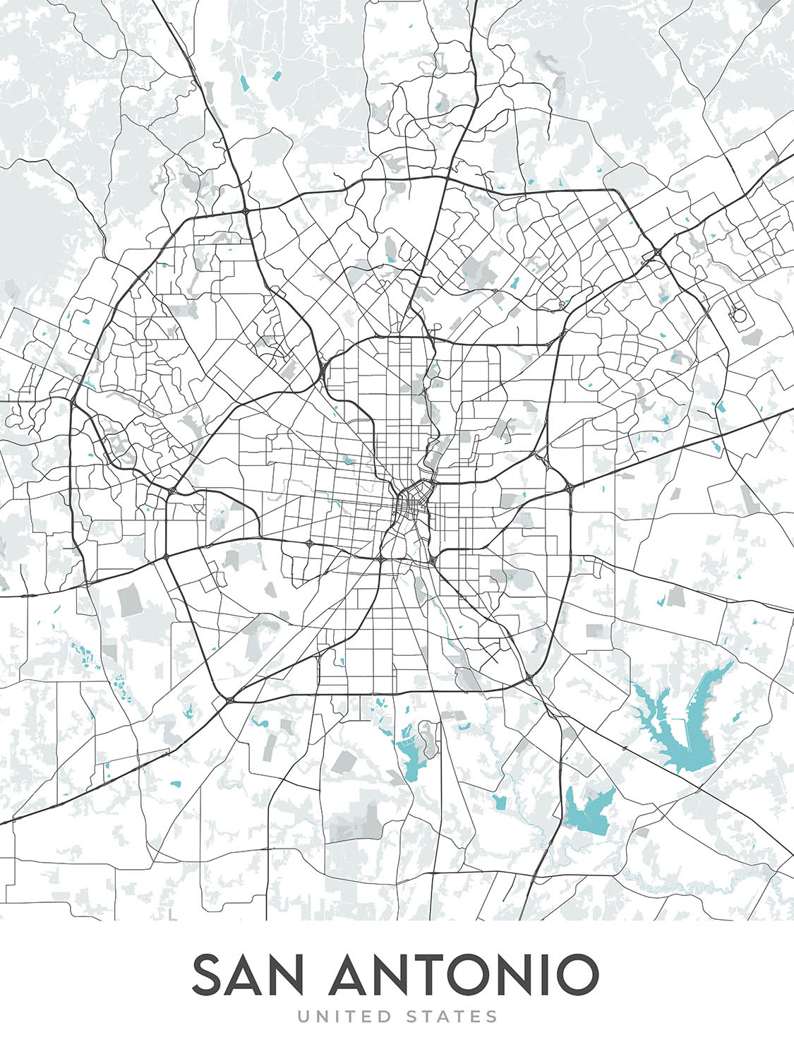
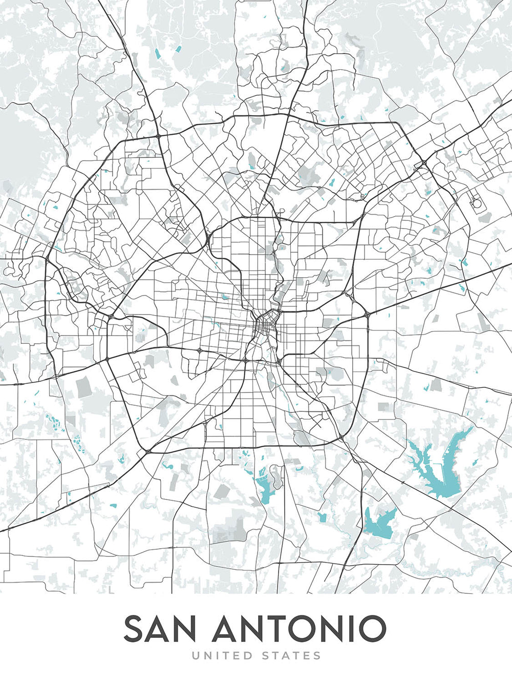
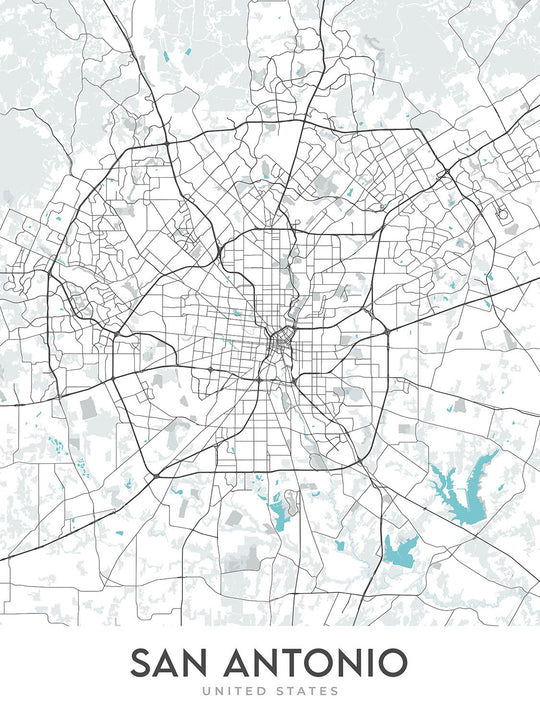


Modern City Map of San Antonio, TX: Alamo, River Walk, AT&T Center, Downtown, I-35
Christmas Express Delivery
You can order up until 10am on December 22 with Express Delivery to receive your order by Christmas.
Unframed products are much more likely to arrive by Christmas. Framed products may arrive on time, but they move more slowly, particularly when couriers are so overloaded with packages.
Personalised orders are unlikely to arrive on time (but if you absolutely must have a personalised product, please contact me and I'll do my best to help!)
Contact me for info on last-minute deliveries.
Spend £250, Save £50 Christmas Express Delivery available
Christmas Express Delivery
You can order up until 10am on December 22 with Express Delivery to receive your order by Christmas.
Unframed products are much more likely to arrive by Christmas. Framed products may arrive on time, but they move more slowly, particularly when couriers are so overloaded with packages.
Personalised orders are unlikely to arrive on time (but if you absolutely must have a personalised product, please contact me and I'll do my best to help!)
Contact me for info on last-minute deliveries.
Spend £250, Save £50

-
![]() Handmade in the UK (we're based in London)
Handmade in the UK (we're based in London)
-
FREE delivery in 3-4 days ⓘ
Free delivery in 3-4 days
Your map should be delivered in 3-4 working days with free delivery, worldwide.
Please use Express Delivery at checkout for Christmas orders. Framed orders may arrive with Express Delivery, but it is not guaranteed.
New for 2025: After you order, you can send a beautiful gift preview by email, if you're worried it won't arrive on time.
We make maps by hand locally in 23 countries, including the UK
![]() . If you're buying a gift for someone in another country, we will make the map locally to them.
. If you're buying a gift for someone in another country, we will make the map locally to them.You will never pay import tax or customs duty.
Check the Christmas delivery guide for order deadlines. Delivery times are starting to slow down, and will continue to slow down towards Christmas.
Express delivery is available at checkout which can reduce the delivery time to 1-2 days.
Please note that personalised maps, and larger framed maps, can take longer to produce and deliver.
If you need your order to arrive by a certain date, contact me and we can discuss your options.
-
FREE gift preview
ⓘ
Digital gift preview
New for 2025: After you complete your order, you can send a beautiful digital preview to the gift recipient. Just provide their email address and we'll do the rest. (Their email address will not be stored or used for any other purpose.)
This is perfect for Christmas gifting, particularly if you're concerned that your order might not arrive in time for Christmas.
-
90 day money back guarantee
ⓘ
90 days to return and refund
Products can be returned within 90 days for a full refund, or exchange for another product.
For personalised and custom made items, we may offer you store credit or a non-expiring gift card, as we cannot resell personalised orders.
If you have any questions, get in touch. For more information, see our full returns & exchanges policy.

My maps are rare, museum-grade, restored old maps sourced from libraries, auction houses and private collections across the globe.
Framing & free personalisation available
1. Select your size
2. Frame & personalise your map
There is limited framing & personalisation capacity available. Order by 10am tomorrow for Christmas delivery.


Gift message & custom finish

If you want to add a gift message, or a finish (jigsaw, aluminium board, etc.) that is not available here, please request it in the "order note" when you check out.
Every order is custom made, so if you need the size adjusted slightly, or printed on an unusual material, just let us know. We've done thousands of custom orders over the years, so there's (almost) nothing we can't manage.
You can also contact us before you order, if you prefer!

- Handmade locally. No import duty or tax
- FREE Delivery by Christmas
- Love it or your money back (90 days)
- Questions? WhatsApp me any time
Own a piece of history
5,000+ 5 star reviews


This map of San Antonio, Texas, is a modern, detailed street map without labels. The map covers a rectangular area that extends approximately 52 miles from top to bottom and 44 miles from left to right. The city of San Antonio is located in the south-central part of Texas and is the seventh-most populous city in the United States. The map focuses on the urban area of San Antonio and includes many of the city's most notable neighborhoods, landmarks, and thoroughfares.
This original creation by The Unique Maps Co. features unique cartography, modern design, and a striking color palette. The map is a beautiful work of art that will add a touch of sophistication to any home or office. The muted colors and clean lines of the map make it easy to read and visually appealing. This map is perfect for anyone who loves San Antonio or is interested in modern cartography.
The map includes many of San Antonio's most famous landmarks, including the Alamo, the AT&T Center, and the River Walk. It also shows the city's major highways and roads, as well as its many neighborhoods. Some of the notable neighborhoods included on the map are Alamo Heights, Downtown, Monte Vista, Olmos Park, and Tobin Hill.
San Antonio is a vibrant city with a rich history and culture. The city is home to a number of missions, including the Alamo, which is a UNESCO World Heritage Site. San Antonio is also home to a number of museums, art galleries, and theaters. The city is a popular tourist destination and offers a variety of attractions for visitors of all ages.
This map of San Antonio is the perfect way to explore the city and discover its many hidden gems. Whether you are a local or a visitor, this map will help you navigate the city and find all of the best that it has to offer.
Neighbourhoods
- Alamo Heights
- Alta Vista
- Balcones Heights
- Beacon Hill
- Castle Hills
- Downtown
- East Side
- Government Hill
- Hollywood Park
- King William
- Lavaca
- Lincoln Heights
- Monte Vista
- Olmos Park
- Pearl
- Tobin Hill
- Uptown
- West Side
- Woodlawn Lake
Towns
- Boerne
- Cibolo
- Converse
- Fair Oaks Ranch
- Helotes
- Kirby
- Live Oak
- Lytle
- New Braunfels
- Schertz
- Selma
- Shavano Park
- Universal City
- Von Ormy
- Windcrest
Major Roads, Routes, Highways
- Interstate 10
- Interstate 35
- Interstate 410
- Loop 1604
- Loop 410
- US Highway 281
- US Highway 87
- US Highway 90
- State Highway 16
- State Highway 20
- State Highway 46
- State Highway 151
- State Highway 1604
- State Highway 211
- State Highway 337
- State Highway 356
- State Highway 37
- State Highway 471
Landmarks
- Alamo
- AT&T Center
- Brackenridge Park
- Fort Sam Houston
- Japanese Tea Garden
- La Cantera Quarry Market
- Mission Concepción
- Mission San Antonio de Valero
- Natural Bridge Caverns
- River Walk
- San Antonio Zoo
- SeaWorld San Antonio
- Six Flags Fiesta Texas
- The Shops at La Cantera
- Tower of the Americas
Please note that streets and places are not labelled on this map. I recommend you double check the images to make sure that a specific town or place is shown on this map, or you can contact me to check if a certain location, landmark or feature is shown on this map.
This map looks great at every size, but I always recommend going for a larger size if you have space. That way you can easily make out all of the details.
Please contact me if you’re looking for sizes that are not available on the shop.
The model in the listing images is holding the 18x24in (45x60cm) version of this map.
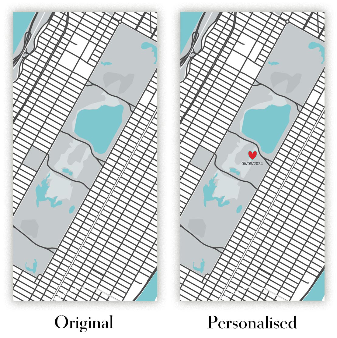
Every map can be personalised or customised, for example if you want to mark your house or street on the map. The fifth listing image shows an example of my map personalisation service.
Every map is available in a range of different colourways and templates, depending on your aesthetic requirements.
If you’re looking for something slightly different, check out my collection of the best old maps to see if something else catches your eye.
This would make a wonderful birthday, Christmas, Father's Day, work leaving, anniversary or housewarming gift for someone from the areas covered by this map.
This map is available as a giclée print on acid free archival matte paper, or you can buy it framed. The frame is a nice, simple black frame that suits most aesthetics. Please get in touch if you'd like a different frame colour or material. My frames are glazed with super-clear museum-grade acrylic (perspex/acrylite), which is significantly less reflective than glass, safer, and will always arrive in perfect condition.
This map is also available as a float framed canvas, sometimes known as a shadow gap framed canvas or canvas floater. The map is printed on artist's cotton canvas and then stretched over a handmade box frame. We then "float" the canvas inside a wooden frame, which is available in a range of colours (black, dark brown, oak, antique gold and white). This is a wonderful way to present a map without glazing in front. See some examples of float framed canvas maps and explore the differences between my different finishes.
For something truly unique, this map is also available in "Unique 3D", our trademarked process that dramatically transforms the map so that it has a wonderful sense of depth. We combine the original map with detailed topography and elevation data, so that mountains and the terrain really "pop". For more info and examples of 3D maps, check my Unique 3D page.
For most orders, delivery time is about 3 working days. Personalised and customised products take longer, as I have to do the personalisation and send it to you for approval, which usually takes 1 or 2 days.
Please note that very large framed orders usually take longer to make and deliver.
If you need your order to arrive by a certain date, please contact me before you order so that we can find the best way of making sure you get your order in time.
I print and frame maps and artwork in 23 countries around the world. This means your order will be made locally, which cuts down on delivery time and ensures that it won't be damaged during delivery. You'll never pay customs or import duty, and we'll put less CO2 into the air.
All of my maps and art prints are well packaged and sent in a rugged tube if unframed, or surrounded by foam if framed.
I try to send out all orders within 1 or 2 days of receiving your order, though some products (like face masks, mugs and tote bags) can take longer to make.
If you select Express Delivery at checkout your order we will prioritise your order and send it out by 1-day courier (Fedex, DHL, UPS, Parcelforce).
Next Day delivery is also available in some countries (US, UK, Singapore, UAE) but please try to order early in the day so that we can get it sent out on time.
My standard frame is a gallery style black ash hardwood frame. It is simple and quite modern looking. My standard frame is around 20mm (0.8in) wide.
I use super-clear acrylic (perspex/acrylite) for the frame glass. It's lighter and safer than glass - and it looks better, as the reflectivity is lower.
Six standard frame colours are available for free (black, dark brown, dark grey, oak, white and antique gold). Custom framing and mounting/matting is available if you're looking for something else.
Most maps, art and illustrations are also available as a framed canvas. We use matte (not shiny) cotton canvas, stretch it over a sustainably sourced box wood frame, and then 'float' the piece within a wood frame. The end result is quite beautiful, and there's no glazing to get in the way.
All frames are provided "ready to hang", with either a string or brackets on the back. Very large frames will have heavy duty hanging plates and/or a mounting baton. If you have any questions, please get in touch.
See some examples of my framed maps and framed canvas maps.
Alternatively, I can also supply old maps and artwork on canvas, foam board, cotton rag and other materials.
If you want to frame your map or artwork yourself, please read my size guide first.
My maps are extremely high quality reproductions of original maps.
I source original, rare maps from libraries, auction houses and private collections around the world, restore them at my London workshop, and then use specialist giclée inks and printers to create beautiful maps that look even better than the original.
My maps are printed on acid-free archival matte (not glossy) paper that feels very high quality and almost like card. In technical terms the paper weight/thickness is 10mil/200gsm. It's perfect for framing.
I print with Epson ultrachrome giclée UV fade resistant pigment inks - some of the best inks you can find.
I can also make maps on canvas, cotton rag and other exotic materials.
Learn more about The Unique Maps Co.
Map personalisation
If you're looking for the perfect anniversary or housewarming gift, I can personalise your map to make it truly unique. For example, I can add a short message, or highlight an important location, or add your family's coat of arms.
The options are almost infinite. Please see my map personalisation page for some wonderful examples of what's possible.
To order a personalised map, select "personalise your map" before adding it to your basket.
Get in touch if you're looking for more complex customisations and personalisations.
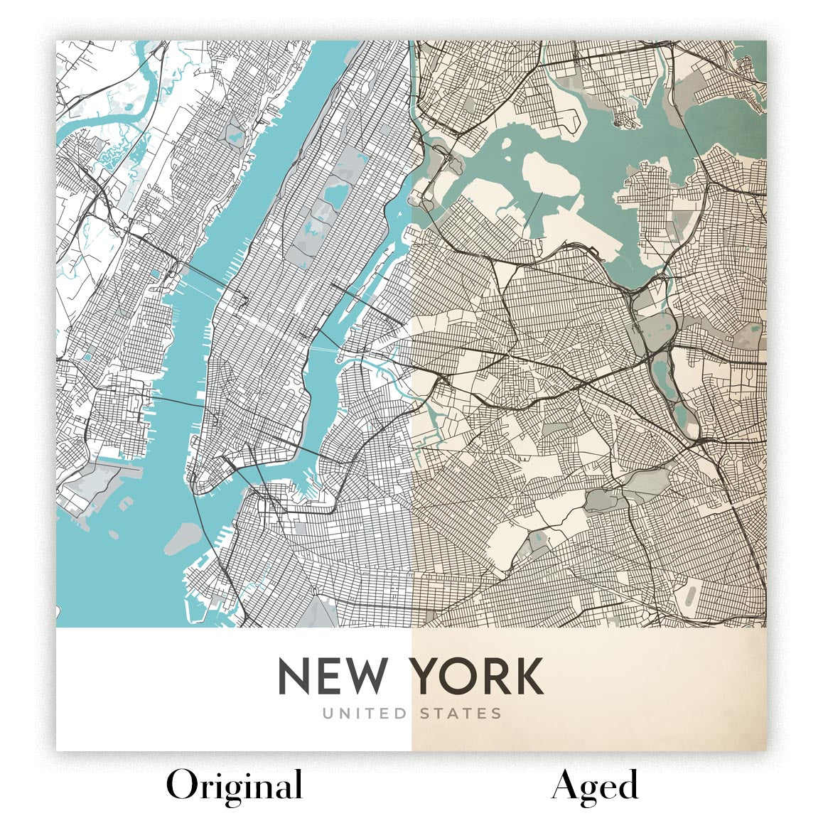
Map ageing
I have been asked hundreds of times over the years by customers if they could buy a map that looks even older.
Well, now you can, by selecting Aged before you add a map to your basket.
All the product photos you see on this page show the map in its Original form. This is what the map looks like today.
If you select Aged, I will age your map by hand, using a special and unique process developed through years of studying old maps, talking to researchers to understand the chemistry of aging paper, and of course... lots of practice!
If you're unsure, stick to the Original colour of the map. If you want something a bit darker and older looking, go for Aged.
If you are not happy with your order for any reason, contact me and I'll get it fixed ASAP, free of charge. Please see my returns and refund policy for more information.
I am very confident you will like your restored map or art print. I have been doing this since 1984. I'm a 5-star Etsy seller. I have sold tens of thousands of maps and art prints and have over 5,000 real 5-star reviews. My work has been featured in interior design magazines, on the BBC, and on the walls of dozens of 5-star hotels.
I use a unique process to restore maps and artwork that is massively time consuming and labour intensive. Hunting down the original maps and illustrations can take months. I use state of the art and eye-wateringly expensive technology to scan and restore them. As a result, I guarantee my maps and art prints are a cut above the rest. I stand by my products and will always make sure you're 100% happy with what you receive.
Almost all of my maps and art prints look amazing at large sizes (200cm, 6.5ft+) and I can frame and deliver them to you as well, via special oversized courier. Contact me to discuss your specific needs.
Or try searching for something!


