


Rare Old Topographic Map of Tasmania by Arrowsmith, 1845: Hobart, Launceston, Derwent R, King & Flinders Is, Lake St Clair
L’offre du collectionneur
Choisissez deux œuvres éligibles et bénéficiez de 20 % de réduction sur les deux. Choisissez-en trois et celle au prix le plus bas est offerte, pour une économie maximale de 33 %.
Associez librement des cartes standard éligibles et des tirages d’art. Aucun code n’est requis ; l’offre est appliquée automatiquement lors du paiement.
Les configurations standard réalisées sur commande sont incluses. Les formats sur mesure, les créations personnalisées et les œuvres commissionnées sont exclus.
Besoin d’une livraison à différentes adresses ? Contactez-nous avant de commander.L’offre du collectionneur
Choisissez deux œuvres éligibles et bénéficiez de 20 % de réduction sur les deux. Choisissez-en trois et celle au prix le plus bas est offerte, pour une économie maximale de 33 %.
Associez librement des cartes standard éligibles et des tirages d’art. Aucun code n’est requis ; l’offre est appliquée automatiquement lors du paiement.
Les configurations standard réalisées sur commande sont incluses. Les formats sur mesure, les créations personnalisées et les œuvres commissionnées sont exclus.
Besoin d’une livraison à différentes adresses ? Contactez-nous avant de commander. Conçu à Londres Fabriqué en the UK
Conçu à Londres • Fabriqué en the UK
Conçu à Londres Fabriqué en the UK
Conçu à Londres • Fabriqué en the UK

Restaurée à partir de la carte originale de 1845 et imprimée en qualité musée. Lire l’histoire de cette carte
Choose your size
Choose your finish


(Plus d’infos)
Message cadeau & finition personnalisée

Si vous souhaitez ajouter un message cadeau, ou une finition (puzzle, panneau en aluminium, etc.) qui n'est pas disponible ici, veuillez le demander dans la "note de commande" lors de votre passage à la caisse.
Chaque commande est fabriquée sur mesure, donc si vous avez besoin d'ajuster légèrement la taille, ou d'imprimer sur un matériau inhabituel, faites-le nous savoir. Nous avons réalisé des milliers de commandes personnalisées au fil des ans, donc il n'y a (presque) rien que nous ne puissions gérer.
Vous pouvez également nous contacter avant de passer votre commande, si vous le souhaitez !

- Fabriqué localement. Livraison sûre
- Sans droits ni frais cachés
- Besoin d’aide ? Appelez-nous ou message WhatsApp
Own a piece of history
8,000+ five-star reviews


Van Diemen's Land is presented here with quiet authority, its title anchoring a composition that balances scientific restraint and painterly grace. Issued...
Continuer la lectureVan Diemen's Land is presented here with quiet authority, its title anchoring a composition that balances scientific restraint and painterly grace. Issued in 1845 within the second edition of Arrowsmith’s New Atlas, the sheet reflects a quarter-century of revision since the first 1825 appearance, its information disciplined by the prime meridian at Greenwich and clarified through a crisp legend and precise scale bar. Hand-colored outlines pick out administrative divisions with clarity, while a lattice of rivers and roads ties coast to interior. Hachures express the muscular topography of the island, from serried ranges to weather-bitten capes, and the surrounding waters are traced with secure, confident coasts punctuated by outlying islands. The result is both a navigational instrument and a historical statement of imperial geographic order.
Aaron Jr. Arrowsmith—heir to the London firm founded by his father—spent more than 25 years distilling the world’s most reliable intelligence into maps and atlases prized by governments, mariners, and emigrants. After 1824 he extended the family’s meticulous standards, drawing on Admiralty charts, colonial surveys, and travelers’ journals to replace conjecture with evidence. His 1845 Van Diemen’s Land exemplifies that method: coastal exactitude joined to an interior increasingly mapped by road-makers, surveyors, and settlers. The plate’s judicious updates register the island’s accelerating transformation, yet its design never overwhelms. Typography is clear, symbols are discriminating, and color serves legibility rather than spectacle—hallmarks of an Arrowsmith production, where synthesis and restraint carry the reader across unfamiliar ground with unforced confidence.
The physical geography of Tasmania unfolds in finely stepped relief. Hachures articulate the mountainous backbone of the west and the broad shoulders of the Central Highlands, their slopes grading toward lake-dotted plateaux and river valleys. The Derwent threads southward past Hobart, while the Tamar leads the eye inland from the northern coast to Launceston; the Mersey and Huon are equally well stated, with smaller tributaries delicately feathered. Lakes Sorell and Crescent punctuate the interior, while Lake St Clair anchors the high country. Around the coasts, headlands and embayments are cleanly drawn, and the outliers of Bass Strait—King Island to the northwest and the Furneaux Group with Flinders Island to the northeast—frame the island within its maritime setting, signaling routes, risks, and resources.
Arrowsmith balances terrain with the living geography of settlement and administration. Hand-colored borders subdivide the colony into recognizable counties and districts, rendering governance legible at a glance. Cities and towns are marked with crisp prominence—Hobart and Launceston foremost, with Devonport, Burnie, and Kingston likewise inscribed—while the road network ties these nodes together in practical skeins. The principal overland artery between Hobart and Launceston is clearly indicated, its branches reaching eastward to coastal townships and westward toward resource-rich country. Ports, anchorages, ferries, and river crossings are signaled with unobtrusive symbols explained in the legend, helping the reader decode movement and connection across an island where sea-lanes, coach roads, and river valleys shaped every economic and social exchange.
Historically, this map sits at a pivotal moment: Van Diemen’s Land, still bearing its penal-era name, was turning toward a broader civic identity that would culminate in the adoption of “Tasmania” a decade later. The 1845 state of knowledge—codified here through Greenwich-referenced longitudes, measured scales, and a disciplined symbology—captures that transition in cartographic form. As a tool, it served administrators, surveyors, and voyagers; as an artifact, it testifies to the British project of knowing and ordering distant lands. Its careful updates across a 25-year span allow one to read change itself—new roads stitched in, districts redefined, settlements brightening into towns—while its elegant economy of line and color ensures the island’s varied character remains the true subject on the page.
Cities and towns on this map
- Hobart (capital and largest city)
- Launceston
- Devonport
- Burnie
- Kingston
Notable Features & Landmarks
- Hand-colored administrative boundaries
- Cities and towns marked prominently
- Major rivers and lakes outlined
- Roads connecting various settlements depicted
- Depiction of islands surrounding Van Diemen's Land
- Hachured relief indicating mountainous regions
- Prime meridian established at Greenwich noted
- Legend or explanatory notes providing essential details on map features
- Scale bar indicating distance measurements
Historical and design context
- Creation Date: 1845
- Mapmaker: Aaron Jr. Arrowsmith — produced detailed maps and atlases for over 25 years, continuing A. Arrowsmith Sr.’s legacy after 1824
- Edition Context: Part of the second edition of “Arrowsmith’s New Atlas” (first published 1825), updated to reflect 25 years of geographical changes
- Geographical Coverage: Focuses on Van Diemen’s Land (now Tasmania) and surrounding waters
- Historical Significance: Captures significant early 19th-century geographical changes and serves as both a navigational tool and historical artifact
Please double check the images to make sure that a specific town or place is shown on this map. You can also get in touch and ask us to check the map for you.
This map looks great at every size, but I always recommend going for a larger size if you have space. That way you can easily make out all of the details.
This map looks amazing at sizes all the way up to 50in (125cm). If you are looking for a larger map, please get in touch.
The model in the listing images is holding the 16x20in (40x50cm) version of this map.
The fifth listing image shows an example of my map personalisation service.
If you’re looking for something slightly different, check out my collection of the best old maps to see if something else catches your eye.
Please contact me to check if a certain location, landmark or feature is shown on this map.
This would make a wonderful birthday, Christmas, Father's Day, work leaving, anniversary or housewarming gift for someone from the areas covered by this map.
This map is available as a giclée print on acid free archival matte paper, or you can buy it framed. The frame is a nice, simple black frame that suits most aesthetics. Please get in touch if you'd like a different frame colour or material. My frames are glazed with super-clear museum-grade acrylic (perspex/acrylite), which is significantly less reflective than glass, safer, and will always arrive in perfect condition.
This map is also available as a float framed canvas, sometimes known as a shadow gap framed canvas or canvas floater. The map is printed on artist's cotton canvas and then stretched over a handmade box frame. We then "float" the canvas inside a wooden frame, which is available in a range of colours (black, dark brown, oak, antique gold and white). This is a wonderful way to present a map without glazing in front. See some examples of float framed canvas maps and explore the differences between my different finishes.
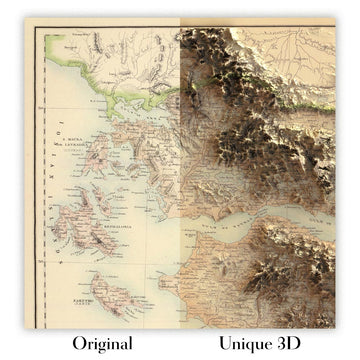
For something truly unique, this map is also available in "Unique 3D", our trademarked process that dramatically transforms the map so that it has a wonderful sense of depth. We combine the original map with detailed topography and elevation data, so that mountains and the terrain really "pop". For more info and examples of 3D maps, check my Unique 3D page.
Van Diemen's Land is presented here with quiet authority, its title anchoring a composition that balances scientific restraint and painterly grace. Issued in 1845 within the second edition of Arrowsmith’s New Atlas, the sheet reflects a quarter-century of revision since the first 1825 appearance, its information disciplined by the prime meridian at Greenwich and clarified through a crisp legend and precise scale bar. Hand-colored outlines pick out administrative divisions with clarity, while a lattice of rivers and roads ties coast to interior. Hachures express the muscular topography of the island, from serried ranges to weather-bitten capes, and the surrounding waters are traced with secure, confident coasts punctuated by outlying islands. The result is both a navigational instrument and a historical statement of imperial geographic order.
Aaron Jr. Arrowsmith—heir to the London firm founded by his father—spent more than 25 years distilling the world’s most reliable intelligence into maps and atlases prized by governments, mariners, and emigrants. After 1824 he extended the family’s meticulous standards, drawing on Admiralty charts, colonial surveys, and travelers’ journals to replace conjecture with evidence. His 1845 Van Diemen’s Land exemplifies that method: coastal exactitude joined to an interior increasingly mapped by road-makers, surveyors, and settlers. The plate’s judicious updates register the island’s accelerating transformation, yet its design never overwhelms. Typography is clear, symbols are discriminating, and color serves legibility rather than spectacle—hallmarks of an Arrowsmith production, where synthesis and restraint carry the reader across unfamiliar ground with unforced confidence.
The physical geography of Tasmania unfolds in finely stepped relief. Hachures articulate the mountainous backbone of the west and the broad shoulders of the Central Highlands, their slopes grading toward lake-dotted plateaux and river valleys. The Derwent threads southward past Hobart, while the Tamar leads the eye inland from the northern coast to Launceston; the Mersey and Huon are equally well stated, with smaller tributaries delicately feathered. Lakes Sorell and Crescent punctuate the interior, while Lake St Clair anchors the high country. Around the coasts, headlands and embayments are cleanly drawn, and the outliers of Bass Strait—King Island to the northwest and the Furneaux Group with Flinders Island to the northeast—frame the island within its maritime setting, signaling routes, risks, and resources.
Arrowsmith balances terrain with the living geography of settlement and administration. Hand-colored borders subdivide the colony into recognizable counties and districts, rendering governance legible at a glance. Cities and towns are marked with crisp prominence—Hobart and Launceston foremost, with Devonport, Burnie, and Kingston likewise inscribed—while the road network ties these nodes together in practical skeins. The principal overland artery between Hobart and Launceston is clearly indicated, its branches reaching eastward to coastal townships and westward toward resource-rich country. Ports, anchorages, ferries, and river crossings are signaled with unobtrusive symbols explained in the legend, helping the reader decode movement and connection across an island where sea-lanes, coach roads, and river valleys shaped every economic and social exchange.
Historically, this map sits at a pivotal moment: Van Diemen’s Land, still bearing its penal-era name, was turning toward a broader civic identity that would culminate in the adoption of “Tasmania” a decade later. The 1845 state of knowledge—codified here through Greenwich-referenced longitudes, measured scales, and a disciplined symbology—captures that transition in cartographic form. As a tool, it served administrators, surveyors, and voyagers; as an artifact, it testifies to the British project of knowing and ordering distant lands. Its careful updates across a 25-year span allow one to read change itself—new roads stitched in, districts redefined, settlements brightening into towns—while its elegant economy of line and color ensures the island’s varied character remains the true subject on the page.
Cities and towns on this map
- Hobart (capital and largest city)
- Launceston
- Devonport
- Burnie
- Kingston
Notable Features & Landmarks
- Hand-colored administrative boundaries
- Cities and towns marked prominently
- Major rivers and lakes outlined
- Roads connecting various settlements depicted
- Depiction of islands surrounding Van Diemen's Land
- Hachured relief indicating mountainous regions
- Prime meridian established at Greenwich noted
- Legend or explanatory notes providing essential details on map features
- Scale bar indicating distance measurements
Historical and design context
- Creation Date: 1845
- Mapmaker: Aaron Jr. Arrowsmith — produced detailed maps and atlases for over 25 years, continuing A. Arrowsmith Sr.’s legacy after 1824
- Edition Context: Part of the second edition of “Arrowsmith’s New Atlas” (first published 1825), updated to reflect 25 years of geographical changes
- Geographical Coverage: Focuses on Van Diemen’s Land (now Tasmania) and surrounding waters
- Historical Significance: Captures significant early 19th-century geographical changes and serves as both a navigational tool and historical artifact
Please double check the images to make sure that a specific town or place is shown on this map. You can also get in touch and ask us to check the map for you.
This map looks great at every size, but I always recommend going for a larger size if you have space. That way you can easily make out all of the details.
This map looks amazing at sizes all the way up to 50in (125cm). If you are looking for a larger map, please get in touch.
The model in the listing images is holding the 16x20in (40x50cm) version of this map.
The fifth listing image shows an example of my map personalisation service.
If you’re looking for something slightly different, check out my collection of the best old maps to see if something else catches your eye.
Please contact me to check if a certain location, landmark or feature is shown on this map.
This would make a wonderful birthday, Christmas, Father's Day, work leaving, anniversary or housewarming gift for someone from the areas covered by this map.
This map is available as a giclée print on acid free archival matte paper, or you can buy it framed. The frame is a nice, simple black frame that suits most aesthetics. Please get in touch if you'd like a different frame colour or material. My frames are glazed with super-clear museum-grade acrylic (perspex/acrylite), which is significantly less reflective than glass, safer, and will always arrive in perfect condition.
This map is also available as a float framed canvas, sometimes known as a shadow gap framed canvas or canvas floater. The map is printed on artist's cotton canvas and then stretched over a handmade box frame. We then "float" the canvas inside a wooden frame, which is available in a range of colours (black, dark brown, oak, antique gold and white). This is a wonderful way to present a map without glazing in front. See some examples of float framed canvas maps and explore the differences between my different finishes.
For something truly unique, this map is also available in "Unique 3D", our trademarked process that dramatically transforms the map so that it has a wonderful sense of depth. We combine the original map with detailed topography and elevation data, so that mountains and the terrain really "pop". For more info and examples of 3D maps, check my Unique 3D page.
Many of our maps and art prints are chosen as thoughtful gifts for homes, offices, studies and meaningful places.
Choose a framed option for the easiest ready-to-hang gift, or choose an unframed print if the recipient may prefer to select their own frame.
We make orders locally in 23 countries around the world, so gifts can often be produced close to the recipient. This helps them arrive faster, travel more safely, and avoid customs or import duty surprises.
- We can deliver directly to the recipient
- Framed pieces arrive ready to hang
- Unframed prints are carefully packed in a strong protective tube
- Almost every order is made locally, for faster, safer gifting
- 90-day returns give the recipient time to decide
If you are not sure what to choose, please contact us. We can help you pick the right map, size, finish or delivery option.
Pour la plupart des commandes, le délai de livraison est d'environ 3 jours ouvrables. Les produits personnalisés et sur mesure prennent plus de temps, car je dois faire la personnalisation et vous l'envoyer pour approbation, ce qui prend généralement 1 ou 2 jours.
Veuillez noter que les grandes commandes encadrées prennent généralement plus de temps à réaliser et à livrer.
Si vous avez besoin que votre commande arrive à une date précise, veuillez me contacter avant de passer votre commande afin que nous puissions trouver le meilleur moyen de nous assurer que vous receviez votre commande à temps.
J'imprime et encadre des cartes et des œuvres d'art dans 23 pays à travers le monde. Cela signifie que votre commande sera réalisée localement, ce qui réduit le temps de livraison et garantit qu'elle ne sera pas endommagée pendant le transport. Vous ne paierez jamais de droits de douane ou d'importation, et nous mettrons moins de CO2 dans l'air.
Toutes mes cartes et impressions artistiques sont bien emballées et envoyées dans un tube robuste si non encadrées, ou entourées de mousse si encadrées.
J'essaie d'envoyer toutes les commandes dans les 1 ou 2 jours suivant la réception de votre commande, bien que certains produits (comme les masques, les mugs et les sacs fourre-tout) puissent prendre plus de temps à réaliser.
Si vous choisissez Livraison Express lors du paiement, nous donnerons la priorité à votre commande et l'enverrons par un service de messagerie de 1 jour (Fedex, DHL, UPS, Parcelforce).
La livraison le lendemain est également disponible dans certains pays (États-Unis, Royaume-Uni, Singapour, Émirats Arabes Unis), mais veuillez essayer de commander tôt dans la journée afin que nous puissions l'envoyer à temps.
Lisez mon guide complet sur la livraison et la production locale
Mon cadre standard est un cadre en bois dur noir de style galerie. Il est simple et a un aspect assez moderne. Mon cadre standard mesure environ 20 mm (0,8 po) de large.
J'utilise de l'acrylique super clair (perspex/acrylite) pour le verre du cadre. C'est plus léger et plus sûr que le verre - et cela a meilleur aspect, car la réflexivité est plus faible.
Six couleurs de cadre standard sont disponibles gratuitement (noir, marron foncé, gris foncé, chêne, blanc et or antique). Des encadrements et montages/matelassages personnalisés sont disponibles si vous recherchez autre chose.
La plupart des cartes, œuvres d'art et illustrations sont également disponibles sous forme de toile encadrée. Nous utilisons une toile en coton mate (non brillante), que nous tendons sur un cadre en bois de boîte provenant de sources durables, puis nous 'flottions' la pièce à l'intérieur d'un cadre en bois. Le résultat final est assez beau, et il n'y a pas de vitrage qui gêne.
Tous les cadres sont fournis "prêts à accrocher", avec soit une corde, soit des supports à l'arrière. Les très grands cadres auront des plaques de suspension lourdes et/ou une latte de montage. Si vous avez des questions, veuillez nous contacter.
Voir quelques exemples de mes cartes encadrées et de cartes en toile encadrées.
Alternativement, je peux également fournir de vieilles cartes et œuvres d'art sur toile, sur panneau en mousse, en coton et d'autres matériaux.
Si vous souhaitez encadrer votre carte ou œuvre d'art vous-même, veuillez lire d'abord mon guide des tailles.
Mes cartes sont des reproductions de cartes originales de très haute qualité.
Je recherche des cartes originales et rares auprès de bibliothèques, de maisons de ventes aux enchères et de collections privées du monde entier, je les restaure dans mon atelier de Londres, puis j'utilise des encres et des imprimantes giclées spécialisées pour créer de magnifiques cartes encore plus belles que l'originale.
Mes cartes sont imprimées sur du papier d’archives mat (non brillant) sans acide qui semble de très haute qualité et ressemble presque à une carte. En termes techniques, le grammage/épaisseur du papier est de 10 mil/200 g/m². C'est parfait pour l'encadrement.
J’imprime avec des encres pigmentaires Epson ultrachrome giclée UV résistantes à la décoloration – certaines des meilleures encres que vous puissiez trouver.
je peux aussi faire cartes sur toile, chiffon en coton et autres matériaux exotiques.
En savoir plus sur Unique Maps Co..
Personnalisation de la carte
Si vous recherchez le cadeau parfait pour un anniversaire ou une pendaison de crémaillère, je peux personnaliser votre carte pour la rendre vraiment unique. Par exemple, je peux ajouter un court message, mettre en évidence un lieu important ou ajouter les armoiries de votre famille.
Les options sont presque infinies. S'il vous plaît voir mon page de personnalisation de la carte pour quelques merveilleux exemples de ce qui est possible.
Pour commander une carte personnalisée, sélectionnez « personnaliser votre carte » avant de l'ajouter à votre panier.
Entrer en contact si vous recherchez des personnalisations et des personnalisations plus complexes.
Vieillissement de la carte
Au fil des ans, des clients m'ont demandé des centaines de fois s'ils pouvaient acheter une carte qui semble uniforme. plus vieux.
Eh bien, vous pouvez désormais le faire en sélectionnant Aged avant d'ajouter une carte à votre panier.
Toutes les photos de produits que vous voyez sur cette page montrent la carte dans sa forme originale. Voilà à quoi ressemble la carte aujourd'hui.
Si vous sélectionnez Vieilli, je vieillirai votre carte à la main, en utilisant un processus spécial et unique développé au cours d'années d'étude de cartes anciennes, de discussions avec des chercheurs pour comprendre la chimie du vieillissement du papier, et bien sûr... beaucoup de pratique !
Si vous n'êtes pas sûr, respectez la couleur originale de la carte. Si vous voulez quelque chose d'un peu plus sombre et plus vieux à la recherche, optez pour Aged.
Si vous n'êtes pas satisfait de votre commande pour une raison quelconque, contactez-moi pour un remboursement sans conditions. Veuillez consulter notre politique de retours et de remboursements pour plus d'informations.
Je suis très confiant que vous aimerez votre carte restaurée ou votre impression artistique. Je fais cela depuis 1984. Je suis un vendeur Etsy 5 étoiles. J'ai vendu des dizaines de milliers de cartes et d'impressions artistiques et j'ai plus de 5 000 vrais avis 5 étoiles.
J'utilise un processus unique pour restaurer des cartes et des œuvres d'art qui est extrêmement chronophage et exigeant en main-d'œuvre. Trouver les cartes et illustrations originales peut prendre des mois. J'utilise une technologie de pointe et incroyablement coûteuse pour les numériser et les restaurer. En conséquence, je garantis que mes cartes et impressions artistiques sont d'une qualité supérieure - c'est pourquoi je peux offrir un remboursement sans conditions.
Presque toutes mes cartes et impressions artistiques ont l'air incroyables en grandes tailles (200 cm, 6,5 pieds+) et je peux également les encadrer et vous les livrer, via un transporteur spécial surdimensionné. Contactez-moi pour discuter de vos besoins spécifiques.
Or try searching for something!


