


Carte picturale de la route aérienne Los Angeles-Kansas City, 1929: Grand Canyon, montagnes Rocheuses, Western Air Express
Livraison pour la fête des Pères
La période de livraison gratuite pour la fête des Pères touche presque à sa fin. Les commandes passées aujourd’hui avec livraison gratuite peuvent encore arriver à temps.
La livraison express est disponible au moment du paiement pour une livraison en 1 à 2 jours, et la livraison le lendemain est disponible dans certains pays pour les commandes passées avant 10 h.
Les commandes personnalisées peuvent prendre un peu plus de temps, car nous préparons une épreuve de design pour votre approbation avant la fabrication et l’expédition de votre commande.
Après votre commande, vous pouvez envoyer un magnifique aperçu cadeau numérique au destinataire. C’est idéal si vous craignez que la commande n’arrive pas à temps pour la fête des Pères.
Veuillez commander dès que possible afin de maximiser vos chances de livraison à temps pour la fête des Pères.
Contactez-nous si vous souhaitez de l’aide pour choisir l’option la plus rapide.
 Conçu à Londres Fabriqué en the UK
Conçu à Londres • Fabriqué en the UK
Conçu à Londres Fabriqué en the UK
Conçu à Londres • Fabriqué en the UK

Choose your size
Choose your finish


(Plus d’infos)
Message cadeau & finition personnalisée

Si vous souhaitez ajouter un message cadeau, ou une finition (puzzle, panneau en aluminium, etc.) qui n'est pas disponible ici, veuillez le demander dans la "note de commande" lors de votre passage à la caisse.
Chaque commande est fabriquée sur mesure, donc si vous avez besoin d'ajuster légèrement la taille, ou d'imprimer sur un matériau inhabituel, faites-le nous savoir. Nous avons réalisé des milliers de commandes personnalisées au fil des ans, donc il n'y a (presque) rien que nous ne puissions gérer.
Vous pouvez également nous contacter avant de passer votre commande, si vous le souhaitez !

- Made locally for fast, safe delivery
- No import duty or hidden fees
- Need advice? Message us on WhatsApp
Own a piece of history
7,000+ 5 star reviews


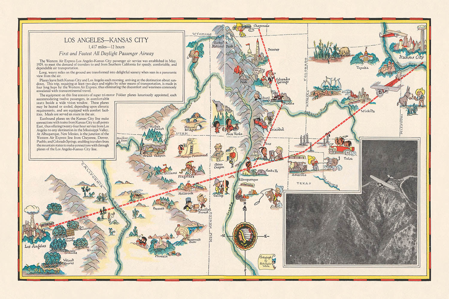
Entrez dans l'âge d'or de l'aviation avec cette remarquable carte picturale de 1929, « Los Angeles-Kansas City », réalisée par la célèbre cartographe Ruth Taylor White pour Western Air Express. Cette carte se dresse comme un vibrant témoignage de l'aube du transport aérien commercial aux États-Unis, commémorant la première ligne de passagers de jour s'étendant sur 1 417 miles de Los Angeles à Kansas City. Plus qu'un simple outil de navigation, cette carte est une célébration du progrès technologique, capturant l'esprit d'innovation et d'aventure qui a défini la fin des années 1920. Elle offre une fenêtre unique sur une époque transformative, où traverser le continent par les airs en seulement 12 heures était rien de moins que révolutionnaire.
L'art de Ruth Taylor White brille à travers chaque détail, alliant cartographie informative et illustration fantaisiste. L'itinéraire est audacieusement tracé à travers le paysage américain, ponctué de charmantes représentations de grandes villes telles que Los Angeles, Albuquerque, Amarillo et Kansas City. En chemin, la carte met en lumière la géographie diversifiée de l'Ouest et du Midwest américains, avec des montagnes, des rivières et des forêts stylisées rendues dans des couleurs vives. Des sites remarquables, y compris le majestueux Grand Canyon et le puissant fleuve Colorado, prennent vie avec des embellissements picturaux délicieux, invitant le spectateur à imaginer les paysages qui attendent les premiers voyageurs aériens.
Ce qui distingue vraiment cette carte, c'est son intégration de thèmes culturels et récréatifs, reflétant l'attrait multifacette des régions qu'elle traverse. Des illustrations de sports d'hiver et d'été, de chasse, de pêche et de l'industrie locale parsèment le paysage, tandis que des scènes de la vie amérindienne et de l'agriculture régionale évoquent la riche tapisserie du patrimoine américain. Ces éléments transforment la carte en un récit visuel de voyage, offrant à la fois des informations pratiques et un récit engageant de découverte. L'inclusion des temps de vol et des distances entre les arrêts souligne encore le double rôle de la carte en tant qu'outil promotionnel et guide fonctionnel pour le passager pionnier.
La signification historique de cette carte ne peut être sous-estimée. Émise à une époque où le voyage aérien était une nouveauté pour la plupart des Américains, elle a été conçue pour inspirer confiance et excitation dans ce nouveau mode de transport. Le texte promotionnel de la carte, la rose des vents ornée du logo en forme de flèche de Western Air Express, et le slogan « Voyagez par air » parlent tous de l'optimisme et de l'ambition de l'époque. C'est un document qui encapsule la rapide modernisation de la nation, ainsi que la vision audacieuse de ceux qui cherchaient à réduire les distances et à relier les villes à travers les cieux.
Les collectionneurs et les passionnés d'histoire apprécieront tous deux l'héritage durable du travail de Ruth Taylor White. Ses cartes sont célébrées non seulement pour leur précision technique mais aussi pour leur capacité à capturer l'imagination. Cette pièce particulière, avec son détail méticuleux et son exubérance joyeuse, se dresse à la fois comme une œuvre d'art et un artefact historique. Elle offre une rare opportunité de posséder un morceau d'histoire de l'aviation—une carte qui a autrefois inspiré les voyageurs à entreprendre un voyage de vitesse, de confort et de découverte à travers le cœur de l'Amérique.
Endroits sur cette carte
- Los Angeles, Californie
- Kansas City, Missouri
- Albuquerque, Nouveau-Mexique
- Winslow, Arizona
- Kingman, Arizona
- Amarillo, Texas
- Wichita, Kansas
- Santa Fe, Nouveau-Mexique
- Grand Canyon (Arizona)
- Fleuve Colorado
- Montagnes Rocheuses
- Désert de Mojave (Californie)
- Montagnes de San Bernardino (Californie)
- Needles, Californie
- Gallup, Nouveau-Mexique
- Tucumcari, Nouveau-Mexique
- Las Vegas, Nouveau-Mexique
- Santa Rosa, Nouveau-Mexique
- Dodge City, Kansas
- Hutchinson, Kansas
Caractéristiques et monuments notables
- La principale route aérienne de Los Angeles à Kansas City est illustrée de manière proéminente.
- Les grandes villes le long de la route sont étiquetées et représentées avec des icônes picturales.
- Le logo de Western Air Express (point de flèche) est présent, renforçant l'image de marque.
- Une rose des vents est incluse, avec le motif de la flèche.
- La route est marquée avec des distances et des temps de vol estimés entre les arrêts clés.
- Des représentations picturales de montagnes, forêts, rivières et terres agricoles sont dispersées le long de la route.
- Des activités récréatives telles que le ski, la chasse et la pêche sont illustrées.
- Des sites industriels et des zones agricoles sont représentés avec des icônes pertinentes (usines, fermes).
- Des monuments notables, comme le Grand Canyon, sont illustrés et étiquetés.
- La carte inclut des illustrations de figures amérindiennes et de scènes culturelles.
- Des rivières comme le fleuve Colorado sont clairement montrées et étiquetées.
- Les montagnes Rocheuses sont représentées de manière stylisée et picturale.
- La carte inclut des illustrations fantaisistes d'animaux et d'activités régionales.
- Les frontières des États sont montrées, avec les noms des États étiquetés.
- Le slogan « Voyager par avion » est inclus dans le message promotionnel.
- La carte est orientée ouest-est, suivant la direction de la route aérienne.
- Le style pictural met en avant à la fois la beauté naturelle et le progrès moderne.
- La carte souligne la nouveauté et l'excitation du voyage aérien à la fin des années 1920.
Contexte historique et de conception
- Nom de la carte : Los Angeles-Kansas City, créée dans le cadre d'une brochure de Western Air Express.
- Date de création : octobre 1929.
- Cartographe : Ruth Taylor White, une cartographe notable connue pour ses cartes picturales et thématiques au début du 20e siècle.
- Éditeur : Western Air Express, une des premières compagnies aériennes commerciales aux États-Unis.
- Produite pour illustrer et promouvoir les premières routes aériennes passagers entre Los Angeles et Kansas City.
- Commémore le lancement de la première et la plus rapide voie aérienne passagers entièrement diurne, reflétant la croissance rapide et l'innovation dans l'aviation commerciale à la fin des années 1920.
- Contexte de la brochure : Cette carte était l'une des quatre cartes de route picturales à double page incluses dans une brochure de voyage lithographiée, qui présentait également des routes de San Francisco à Los Angeles, de Los Angeles à Tijuana/Agua Caliente et de Los Angeles à Salt Lake City.
- Style de la carte : Thématique et picturale, avec un relief montré de manière picturale ; les monuments, forêts, rivières, montagnes et sites récréatifs sont illustrés dans un style coloré et engageant.
- Éléments de design : Comprend une rose des vents avec un logo de flèche, renforçant l'esprit pionnier de la compagnie aérienne.
- Thèmes représentés : Routes de voyage aérien, temps et distances de vol, caractéristiques géographiques (montagnes, rivières, forêts), activités récréatives, sites industriels et lieux d'intérêt.
- Distance et temps de voyage : La route couvre 1 417 miles et peut être parcourue en 12 heures, un accomplissement significatif pour l'époque.
- Focus promotionnel : Met l'accent sur la vitesse, le confort et la fiabilité du voyage aérien, visant à attirer de nouveaux passagers vers l'aviation commerciale.
- Signification historique : Sert de témoignage aux débuts de l'aviation commerciale et au développement des réseaux de transport aérien aux États-Unis.
- Contexte culturel : Reflète l'optimisme et l'esprit d'innovation des années 1920, ainsi que l'importance croissante du tourisme et des voyages.
- Approche artistique : Utilise des illustrations colorées et de style cartoon pour rendre la carte accessible et attrayante pour le public.
- Notable pour : L'intégration d'informations pratiques sur les voyages avec des éléments artistiques et promotionnels.
- Public : Ciblé vers les voyageurs aériens potentiels, les touristes et le grand public intéressé par les transports modernes.
- Héritage : Les cartes de Ruth Taylor White sont désormais considérées comme des documents historiques précieux et collectionnables.
Veuillez vérifier les images pour vous assurer qu'une ville ou un lieu spécifique est représenté sur cette carte. Vous pouvez également nous contacter et nous demander de vérifier la carte pour vous.
Cette carte est magnifique à toutes les tailles, mais je recommande toujours d'opter pour une taille plus grande si vous avez de l'espace. Cela vous permettra de distinguer facilement tous les détails.
Cette carte est incroyable à des tailles allant jusqu'à 70in (180cm). Si vous recherchez une carte plus grande, veuillez nous contacter.
Le modèle dans les images de la liste tient la version 24x36in (60x90cm) de cette carte.
La cinquième image de la liste montre un exemple de mon service de personnalisation de carte.
Si vous recherchez quelque chose de légèrement différent, consultez ma collection des meilleures anciennes cartes pour voir si quelque chose d'autre attire votre attention.
Veuillez me contacter pour vérifier si un certain emplacement, monument ou caractéristique est représenté sur cette carte.
Cela ferait un merveilleux cadeau d'anniversaire, de Noël, de la fête des pères, de départ au travail, d'anniversaire de mariage ou de pendaison de crémaillère pour quelqu'un des régions couvertes par cette carte.
Cette carte est disponible en tant qu'impression giclée sur papier mat d'archives sans acide, ou vous pouvez l'acheter encadrée. Le cadre est un joli cadre noir simple qui convient à la plupart des esthétiques. Veuillez nous contacter si vous souhaitez une couleur ou un matériau de cadre différent. Mes cadres sont en verre acrylique super clair de qualité muséale (perspex/acrylite), qui est significativement moins réfléchissant que le verre, plus sûr, et arrivera toujours en parfait état.
This map is also available as a float framed canvas, sometimes known as a shadow gap framed canvas or canvas floater. The map is printed on artist's cotton canvas and then stretched over a handmade box frame. We then "float" the canvas inside a wooden frame, which is available in a range of colours (black, dark brown, oak, antique gold and white). This is a wonderful way to present a map without glazing in front. See some examples of float framed canvas maps and explore the differences between my different finishes.
For something truly unique, this map is also available in "Unique 3D", our trademarked process that dramatically transforms the map so that it has a wonderful sense of depth. We combine the original map with detailed topography and elevation data, so that mountains and the terrain really "pop". For more info and examples of 3D maps, check my Unique 3D page.
Many of our maps and art prints are chosen as thoughtful gifts for homes, offices, studies and meaningful places.
Choose a framed option for the easiest ready-to-hang gift, or choose an unframed print if the recipient may prefer to select their own frame.
We make orders locally in 23 countries around the world, so gifts can often be produced close to the recipient. This helps them arrive faster, travel more safely, and avoid customs or import duty surprises.
- We can deliver directly to the recipient
- Framed pieces arrive ready to hang
- Unframed prints are carefully packed in a strong protective tube
- Almost every order is made locally, for faster, safer gifting
- 90-day returns give the recipient time to decide
If you are not sure what to choose, please contact us. We can help you pick the right map, size, finish or delivery option.
Pour la plupart des commandes, le délai de livraison est d'environ 3 jours ouvrables. Les produits personnalisés et sur mesure prennent plus de temps, car je dois faire la personnalisation et vous l'envoyer pour approbation, ce qui prend généralement 1 ou 2 jours.
Veuillez noter que les grandes commandes encadrées prennent généralement plus de temps à réaliser et à livrer.
Si vous avez besoin que votre commande arrive à une date précise, veuillez me contacter avant de passer votre commande afin que nous puissions trouver le meilleur moyen de nous assurer que vous receviez votre commande à temps.
J'imprime et encadre des cartes et des œuvres d'art dans 23 pays à travers le monde. Cela signifie que votre commande sera réalisée localement, ce qui réduit le temps de livraison et garantit qu'elle ne sera pas endommagée pendant le transport. Vous ne paierez jamais de droits de douane ou d'importation, et nous mettrons moins de CO2 dans l'air.
Toutes mes cartes et impressions artistiques sont bien emballées et envoyées dans un tube robuste si non encadrées, ou entourées de mousse si encadrées.
J'essaie d'envoyer toutes les commandes dans les 1 ou 2 jours suivant la réception de votre commande, bien que certains produits (comme les masques, les mugs et les sacs fourre-tout) puissent prendre plus de temps à réaliser.
Si vous choisissez Livraison Express lors du paiement, nous donnerons la priorité à votre commande et l'enverrons par un service de messagerie de 1 jour (Fedex, DHL, UPS, Parcelforce).
La livraison le lendemain est également disponible dans certains pays (États-Unis, Royaume-Uni, Singapour, Émirats Arabes Unis), mais veuillez essayer de commander tôt dans la journée afin que nous puissions l'envoyer à temps.
Lisez mon guide complet sur la livraison et la production locale
Mon cadre standard est un cadre en bois dur noir de style galerie. Il est simple et a un aspect assez moderne. Mon cadre standard mesure environ 20 mm (0,8 po) de large.
J'utilise de l'acrylique super clair (perspex/acrylite) pour le verre du cadre. C'est plus léger et plus sûr que le verre - et cela a meilleur aspect, car la réflexivité est plus faible.
Six couleurs de cadre standard sont disponibles gratuitement (noir, marron foncé, gris foncé, chêne, blanc et or antique). Des encadrements et montages/matelassages personnalisés sont disponibles si vous recherchez autre chose.
La plupart des cartes, œuvres d'art et illustrations sont également disponibles sous forme de toile encadrée. Nous utilisons une toile en coton mate (non brillante), que nous tendons sur un cadre en bois de boîte provenant de sources durables, puis nous 'flottions' la pièce à l'intérieur d'un cadre en bois. Le résultat final est assez beau, et il n'y a pas de vitrage qui gêne.
Tous les cadres sont fournis "prêts à accrocher", avec soit une corde, soit des supports à l'arrière. Les très grands cadres auront des plaques de suspension lourdes et/ou une latte de montage. Si vous avez des questions, veuillez nous contacter.
Voir quelques exemples de mes cartes encadrées et de cartes en toile encadrées.
Alternativement, je peux également fournir de vieilles cartes et œuvres d'art sur toile, sur panneau en mousse, en coton et d'autres matériaux.
Si vous souhaitez encadrer votre carte ou œuvre d'art vous-même, veuillez lire d'abord mon guide des tailles.
Mes cartes sont des reproductions de cartes originales de très haute qualité.
Je recherche des cartes originales et rares auprès de bibliothèques, de maisons de ventes aux enchères et de collections privées du monde entier, je les restaure dans mon atelier de Londres, puis j'utilise des encres et des imprimantes giclées spécialisées pour créer de magnifiques cartes encore plus belles que l'originale.
Mes cartes sont imprimées sur du papier d’archives mat (non brillant) sans acide qui semble de très haute qualité et ressemble presque à une carte. En termes techniques, le grammage/épaisseur du papier est de 10 mil/200 g/m². C'est parfait pour l'encadrement.
J’imprime avec des encres pigmentaires Epson ultrachrome giclée UV résistantes à la décoloration – certaines des meilleures encres que vous puissiez trouver.
je peux aussi faire cartes sur toile, chiffon en coton et autres matériaux exotiques.
En savoir plus sur Unique Maps Co..
Personnalisation de la carte
Si vous recherchez le cadeau parfait pour un anniversaire ou une pendaison de crémaillère, je peux personnaliser votre carte pour la rendre vraiment unique. Par exemple, je peux ajouter un court message, mettre en évidence un lieu important ou ajouter les armoiries de votre famille.
Les options sont presque infinies. S'il vous plaît voir mon page de personnalisation de la carte pour quelques merveilleux exemples de ce qui est possible.
Pour commander une carte personnalisée, sélectionnez « personnaliser votre carte » avant de l'ajouter à votre panier.
Entrer en contact si vous recherchez des personnalisations et des personnalisations plus complexes.
Vieillissement de la carte
Au fil des ans, des clients m'ont demandé des centaines de fois s'ils pouvaient acheter une carte qui semble uniforme. plus vieux.
Eh bien, vous pouvez désormais le faire en sélectionnant Aged avant d'ajouter une carte à votre panier.
Toutes les photos de produits que vous voyez sur cette page montrent la carte dans sa forme originale. Voilà à quoi ressemble la carte aujourd'hui.
Si vous sélectionnez Vieilli, je vieillirai votre carte à la main, en utilisant un processus spécial et unique développé au cours d'années d'étude de cartes anciennes, de discussions avec des chercheurs pour comprendre la chimie du vieillissement du papier, et bien sûr... beaucoup de pratique !
Si vous n'êtes pas sûr, respectez la couleur originale de la carte. Si vous voulez quelque chose d'un peu plus sombre et plus vieux à la recherche, optez pour Aged.
Si vous n'êtes pas satisfait de votre commande pour une raison quelconque, contactez-moi pour un remboursement sans conditions. Veuillez consulter notre politique de retours et de remboursements pour plus d'informations.
Je suis très confiant que vous aimerez votre carte restaurée ou votre impression artistique. Je fais cela depuis 1984. Je suis un vendeur Etsy 5 étoiles. J'ai vendu des dizaines de milliers de cartes et d'impressions artistiques et j'ai plus de 5 000 vrais avis 5 étoiles.
J'utilise un processus unique pour restaurer des cartes et des œuvres d'art qui est extrêmement chronophage et exigeant en main-d'œuvre. Trouver les cartes et illustrations originales peut prendre des mois. J'utilise une technologie de pointe et incroyablement coûteuse pour les numériser et les restaurer. En conséquence, je garantis que mes cartes et impressions artistiques sont d'une qualité supérieure - c'est pourquoi je peux offrir un remboursement sans conditions.
Presque toutes mes cartes et impressions artistiques ont l'air incroyables en grandes tailles (200 cm, 6,5 pieds+) et je peux également les encadrer et vous les livrer, via un transporteur spécial surdimensionné. Contactez-moi pour discuter de vos besoins spécifiques.
Or try searching for something!


