


Ancienne carte du nord de l'Amérique du Sud par Tallis, 1851: Venezuela, Colombie, Équateur, Guyanes, Panama
L’offre du collectionneur
Choisissez deux œuvres éligibles et bénéficiez de 20 % de réduction sur les deux. Choisissez-en trois et celle au prix le plus bas est offerte, pour une économie maximale de 33 %.
Associez librement des cartes standard éligibles et des tirages d’art. Aucun code n’est requis ; l’offre est appliquée automatiquement lors du paiement.
Les configurations standard réalisées sur commande sont incluses. Les formats sur mesure, les créations personnalisées et les œuvres commissionnées sont exclus.
Besoin d’une livraison à différentes adresses ? Contactez-nous avant de commander.L’offre du collectionneur
Choisissez deux œuvres éligibles et bénéficiez de 20 % de réduction sur les deux. Choisissez-en trois et celle au prix le plus bas est offerte, pour une économie maximale de 33 %.
Associez librement des cartes standard éligibles et des tirages d’art. Aucun code n’est requis ; l’offre est appliquée automatiquement lors du paiement.
Les configurations standard réalisées sur commande sont incluses. Les formats sur mesure, les créations personnalisées et les œuvres commissionnées sont exclus.
Besoin d’une livraison à différentes adresses ? Contactez-nous avant de commander. Conçu à Londres Fabriqué en the UK
Conçu à Londres • Fabriqué en the UK
Conçu à Londres Fabriqué en the UK
Conçu à Londres • Fabriqué en the UK

Restaurée à partir de la carte originale de 1851 et imprimée en qualité musée. Lire l’histoire de cette carte
Choose your size
Choose your finish


(Plus d’infos)
Message cadeau & finition personnalisée

Si vous souhaitez ajouter un message cadeau, ou une finition (puzzle, panneau en aluminium, etc.) qui n'est pas disponible ici, veuillez le demander dans la "note de commande" lors de votre passage à la caisse.
Chaque commande est fabriquée sur mesure, donc si vous avez besoin d'ajuster légèrement la taille, ou d'imprimer sur un matériau inhabituel, faites-le nous savoir. Nous avons réalisé des milliers de commandes personnalisées au fil des ans, donc il n'y a (presque) rien que nous ne puissions gérer.
Vous pouvez également nous contacter avant de passer votre commande, si vous le souhaitez !

- Fabriqué localement. Livraison sûre
- Sans droits ni frais cachés
- Besoin d’aide ? Appelez-nous ou message WhatsApp
Own a piece of history
8,000+ five-star reviews


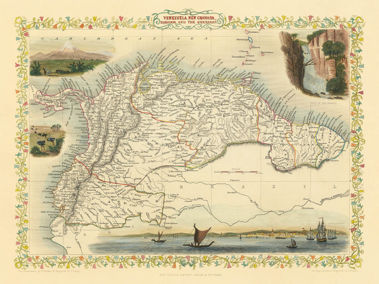
Entrez dans le cœur vibrant de l'Amérique du Sud du 19ème siècle avec la carte exquise de John Tallis de 1851, intitulée...
Continuer la lectureEntrez dans le cœur vibrant de l'Amérique du Sud du 19ème siècle avec la carte exquise de John Tallis de 1851, intitulée à l'origine « Venezuela, Nouvelle Grenade, Équateur et les Guyanes. » Cette œuvre magistrale offre une fenêtre captivante sur une région à la croisée de l'héritage colonial et des identités nationales émergentes. La carte de Tallis se dresse comme un témoignage de la fascination de l'époque pour l'exploration et la découverte, capturant les contours géopolitiques du Venezuela, de la Colombie (alors Nouvelle Grenade), de l'Équateur et des Guyanes — englobant la Guyane moderne, le Suriname et la Guyane française. L'art de la carte n'est égalé que par son importance historique, offrant aux collectionneurs et aux connaisseurs un aperçu rare des frontières et des noms de lieux qui ont défini une époque.
John Tallis, reconnu comme l'un des derniers grands cartographes décoratifs, a imprégné ses œuvres à la fois de précision scientifique et de flair artistique. Gravée pour l'illustre Atlas illustré de R. Montgomery Martin, cette carte est un exemple parfait de l'engagement de Tallis envers le détail et la beauté. Son style distinctif est évident dans les bordures ornées et l'inclusion de vignettes — chacune un tableau miniature capturant l'esprit des terres représentées. Les cartes de Tallis sont célébrées non seulement pour leur précision cartographique mais aussi pour leur capacité à évoquer l'émerveillement et la romance des lieux lointains.
Un point fort de cette carte est sa représentation complexe des merveilles naturelles et des points de repère de la région. Les majestueuses montagnes des Andes s'étendent sur le bord occidental, couronnées par le volcan Chimborazo enneigé en Équateur — un sujet favori des explorateurs et des naturalistes de l'époque. La carte retrace également le parcours de rivières légendaires telles que l'Orénoque, l'Amazone et la Magdalena, chacune étant une bouée de sauvetage pour le commerce, la culture et la biodiversité. Le long des côtes des Caraïbes et du Pacifique, les côtes méticuleusement rendues laissent entrevoir l'importance maritime stratégique de la région.
Tout aussi captivantes sont les vignettes qui ornent les marges de la carte, offrant un voyage visuel à travers les paysages et les cultures du nord de l'Amérique du Sud. Parmi celles-ci, le port animé de Paramaribo au Suriname, les chutes dramatiques de Bagota (les chutes de Tequendama près de Bogotá), et des scènes de faune indigène se distinguent, chacune rendue avec un souci tant de précision que de charme artistique. Ces illustrations transportent le spectateur à une époque où l'Amérique du Sud était une terre de beauté sauvage et de possibilités infinies.
Les frontières politiques détaillées de la carte et ses riches caractéristiques topographiques sont complétées par son annotation minutieuse des principales villes et villages — dont beaucoup ont depuis évolué en certains des centres urbains les plus dynamiques du continent. De Caracas et Bogotá à Quito et Georgetown, les établissements cartographiés ici sont des points de repère de l'histoire et de la culture sud-américaines. Pour le collectionneur exigeant, cette carte est plus qu'un simple enregistrement géographique ; c'est une célébration de l'art, de l'ambition et de l'attrait durable de l'exploration dans une époque charnière.
Villes et villages sur cette carte
- Venezuela :
- Caracas
- Maracaibo
- Valencia
- Barquisimeto
- Mérida
- Cumaná
- Barcelone
- Angostura (maintenant Ciudad Bolívar)
- Colombie (Nouvelle Grenade) :
- Bogotá
- Medellín
- Carthagène
- Cali
- Popayán
- Santa Marta
- Pasto
- Équateur :
- Quito
- Guayaquil
- Cuenca
- Guyane, Suriname, Guyane française (les Guyanes) :
- Georgetown (Guyane)
- Paramaribo (Suriname)
- Cayenne (Guyane française)
Caractéristiques et monuments notables
- Illustrations et vignettes, y compris :
- Paramaribo (Suriname)
- Chimborazo (volcan en Équateur)
- Chutes de Bagota (Chutes de Tequendama près de Bogotá, Colombie)
- Représentations d'animaux indigènes propres à la région
- Mer des Caraïbes
- Océan Pacifique
- Rivière Orénoque
- Rivière Amazone
- Rivière Magdalena
- Montagnes des Andes, y compris Chimborazo
- Frontières politiques clairement délimitées du Venezuela, de la Nouvelle-Grenade (Colombie), de l'Équateur et des Guyanes (Guyana, Suriname, Guyane française)
- Bordure décorative encadrant la carte
- Représentation détaillée de la côte
Contexte historique et de conception
- Créé en 1851 par John Tallis, l'un des derniers grands cartographes décoratifs du 19ème siècle
- Gravé pour l'Atlas illustré de R. Montgomery Martin
- Combine les frontières politiques avec les caractéristiques géographiques physiques, telles que les montagnes, les rivières et les côtes
- Comprend des vignettes détaillées illustrant des scènes locales, des monuments et la faune
- Réflète l'influence coloniale et les divisions territoriales de l'Amérique du Sud au milieu du 19ème siècle
- Caractéristique du style décoratif de Tallis, avec des motifs de bordure complexes et des vignettes artistiques
- Offre des aperçus historiques sur les frontières géopolitiques et les conventions de nommage de l'époque
Veuillez vérifier les images pour vous assurer qu'une ville ou un lieu spécifique est montré sur cette carte. Vous pouvez également nous contacter et nous demander de vérifier la carte pour vous.
Cette carte a fière allure à toutes les tailles, mais je recommande toujours d'opter pour une taille plus grande si vous avez de l'espace. De cette façon, vous pouvez facilement distinguer tous les détails.
Cette carte est incroyable à des tailles allant jusqu'à 50 pouces (125 cm). Si vous recherchez une carte plus grande, veuillez nous contacter.
Le modèle dans les images de la liste tient la version 18x24 pouces (45x60 cm) de cette carte.
La cinquième image de la liste montre un exemple de mon service de personnalisation de carte.
Si vous recherchez quelque chose de légèrement différent, consultez ma collection des meilleures anciennes cartes pour voir si quelque chose d'autre attire votre attention.
Veuillez me contacter pour vérifier si un certain emplacement, monument ou caractéristique est montré sur cette carte.
Cela ferait un merveilleux cadeau d'anniversaire, de Noël, pour la fête des pères, de départ au travail, d'anniversaire de mariage ou de pendaison de crémaillère pour quelqu'un des zones couvertes par cette carte.
Cette carte est disponible en tant qu'impression giclée sur papier mat d'archivage sans acide, ou vous pouvez l'acheter encadrée. Le cadre est un joli cadre noir simple qui convient à la plupart des esthétiques. Veuillez nous contacter si vous souhaitez une couleur ou un matériau de cadre différent. Mes cadres sont vitrées avec un acrylique de musée super clair (perspex/acrylite), qui est significativement moins réfléchissant que le verre, plus sûr, et arrivera toujours en parfait état.
This map is also available as a float framed canvas, sometimes known as a shadow gap framed canvas or canvas floater. The map is printed on artist's cotton canvas and then stretched over a handmade box frame. We then "float" the canvas inside a wooden frame, which is available in a range of colours (black, dark brown, oak, antique gold and white). This is a wonderful way to present a map without glazing in front. See some examples of float framed canvas maps and explore the differences between my different finishes.
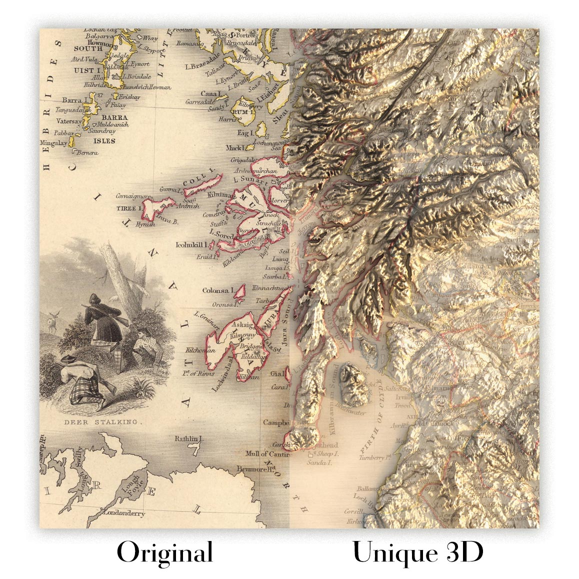
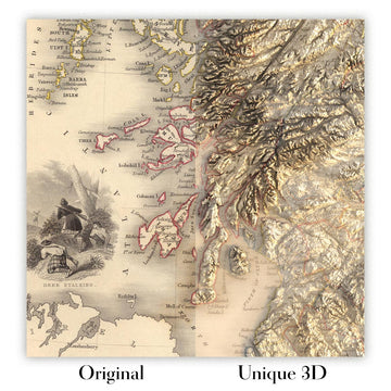
For something truly unique, this map is also available in "Unique 3D", our trademarked process that dramatically transforms the map so that it has a wonderful sense of depth. We combine the original map with detailed topography and elevation data, so that mountains and the terrain really "pop". For more info and examples of 3D maps, check my Unique 3D page.
Entrez dans le cœur vibrant de l'Amérique du Sud du 19ème siècle avec la carte exquise de John Tallis de 1851, intitulée à l'origine « Venezuela, Nouvelle Grenade, Équateur et les Guyanes. » Cette œuvre magistrale offre une fenêtre captivante sur une région à la croisée de l'héritage colonial et des identités nationales émergentes. La carte de Tallis se dresse comme un témoignage de la fascination de l'époque pour l'exploration et la découverte, capturant les contours géopolitiques du Venezuela, de la Colombie (alors Nouvelle Grenade), de l'Équateur et des Guyanes — englobant la Guyane moderne, le Suriname et la Guyane française. L'art de la carte n'est égalé que par son importance historique, offrant aux collectionneurs et aux connaisseurs un aperçu rare des frontières et des noms de lieux qui ont défini une époque.
John Tallis, reconnu comme l'un des derniers grands cartographes décoratifs, a imprégné ses œuvres à la fois de précision scientifique et de flair artistique. Gravée pour l'illustre Atlas illustré de R. Montgomery Martin, cette carte est un exemple parfait de l'engagement de Tallis envers le détail et la beauté. Son style distinctif est évident dans les bordures ornées et l'inclusion de vignettes — chacune un tableau miniature capturant l'esprit des terres représentées. Les cartes de Tallis sont célébrées non seulement pour leur précision cartographique mais aussi pour leur capacité à évoquer l'émerveillement et la romance des lieux lointains.
Un point fort de cette carte est sa représentation complexe des merveilles naturelles et des points de repère de la région. Les majestueuses montagnes des Andes s'étendent sur le bord occidental, couronnées par le volcan Chimborazo enneigé en Équateur — un sujet favori des explorateurs et des naturalistes de l'époque. La carte retrace également le parcours de rivières légendaires telles que l'Orénoque, l'Amazone et la Magdalena, chacune étant une bouée de sauvetage pour le commerce, la culture et la biodiversité. Le long des côtes des Caraïbes et du Pacifique, les côtes méticuleusement rendues laissent entrevoir l'importance maritime stratégique de la région.
Tout aussi captivantes sont les vignettes qui ornent les marges de la carte, offrant un voyage visuel à travers les paysages et les cultures du nord de l'Amérique du Sud. Parmi celles-ci, le port animé de Paramaribo au Suriname, les chutes dramatiques de Bagota (les chutes de Tequendama près de Bogotá), et des scènes de faune indigène se distinguent, chacune rendue avec un souci tant de précision que de charme artistique. Ces illustrations transportent le spectateur à une époque où l'Amérique du Sud était une terre de beauté sauvage et de possibilités infinies.
Les frontières politiques détaillées de la carte et ses riches caractéristiques topographiques sont complétées par son annotation minutieuse des principales villes et villages — dont beaucoup ont depuis évolué en certains des centres urbains les plus dynamiques du continent. De Caracas et Bogotá à Quito et Georgetown, les établissements cartographiés ici sont des points de repère de l'histoire et de la culture sud-américaines. Pour le collectionneur exigeant, cette carte est plus qu'un simple enregistrement géographique ; c'est une célébration de l'art, de l'ambition et de l'attrait durable de l'exploration dans une époque charnière.
Villes et villages sur cette carte
- Venezuela :
- Caracas
- Maracaibo
- Valencia
- Barquisimeto
- Mérida
- Cumaná
- Barcelone
- Angostura (maintenant Ciudad Bolívar)
- Colombie (Nouvelle Grenade) :
- Bogotá
- Medellín
- Carthagène
- Cali
- Popayán
- Santa Marta
- Pasto
- Équateur :
- Quito
- Guayaquil
- Cuenca
- Guyane, Suriname, Guyane française (les Guyanes) :
- Georgetown (Guyane)
- Paramaribo (Suriname)
- Cayenne (Guyane française)
Caractéristiques et monuments notables
- Illustrations et vignettes, y compris :
- Paramaribo (Suriname)
- Chimborazo (volcan en Équateur)
- Chutes de Bagota (Chutes de Tequendama près de Bogotá, Colombie)
- Représentations d'animaux indigènes propres à la région
- Mer des Caraïbes
- Océan Pacifique
- Rivière Orénoque
- Rivière Amazone
- Rivière Magdalena
- Montagnes des Andes, y compris Chimborazo
- Frontières politiques clairement délimitées du Venezuela, de la Nouvelle-Grenade (Colombie), de l'Équateur et des Guyanes (Guyana, Suriname, Guyane française)
- Bordure décorative encadrant la carte
- Représentation détaillée de la côte
Contexte historique et de conception
- Créé en 1851 par John Tallis, l'un des derniers grands cartographes décoratifs du 19ème siècle
- Gravé pour l'Atlas illustré de R. Montgomery Martin
- Combine les frontières politiques avec les caractéristiques géographiques physiques, telles que les montagnes, les rivières et les côtes
- Comprend des vignettes détaillées illustrant des scènes locales, des monuments et la faune
- Réflète l'influence coloniale et les divisions territoriales de l'Amérique du Sud au milieu du 19ème siècle
- Caractéristique du style décoratif de Tallis, avec des motifs de bordure complexes et des vignettes artistiques
- Offre des aperçus historiques sur les frontières géopolitiques et les conventions de nommage de l'époque
Veuillez vérifier les images pour vous assurer qu'une ville ou un lieu spécifique est montré sur cette carte. Vous pouvez également nous contacter et nous demander de vérifier la carte pour vous.
Cette carte a fière allure à toutes les tailles, mais je recommande toujours d'opter pour une taille plus grande si vous avez de l'espace. De cette façon, vous pouvez facilement distinguer tous les détails.
Cette carte est incroyable à des tailles allant jusqu'à 50 pouces (125 cm). Si vous recherchez une carte plus grande, veuillez nous contacter.
Le modèle dans les images de la liste tient la version 18x24 pouces (45x60 cm) de cette carte.
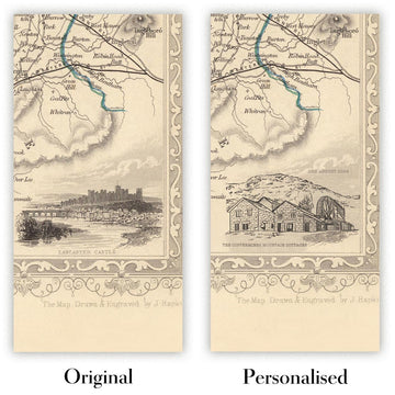
La cinquième image de la liste montre un exemple de mon service de personnalisation de carte.
Si vous recherchez quelque chose de légèrement différent, consultez ma collection des meilleures anciennes cartes pour voir si quelque chose d'autre attire votre attention.
Veuillez me contacter pour vérifier si un certain emplacement, monument ou caractéristique est montré sur cette carte.
Cela ferait un merveilleux cadeau d'anniversaire, de Noël, pour la fête des pères, de départ au travail, d'anniversaire de mariage ou de pendaison de crémaillère pour quelqu'un des zones couvertes par cette carte.
Cette carte est disponible en tant qu'impression giclée sur papier mat d'archivage sans acide, ou vous pouvez l'acheter encadrée. Le cadre est un joli cadre noir simple qui convient à la plupart des esthétiques. Veuillez nous contacter si vous souhaitez une couleur ou un matériau de cadre différent. Mes cadres sont vitrées avec un acrylique de musée super clair (perspex/acrylite), qui est significativement moins réfléchissant que le verre, plus sûr, et arrivera toujours en parfait état.
This map is also available as a float framed canvas, sometimes known as a shadow gap framed canvas or canvas floater. The map is printed on artist's cotton canvas and then stretched over a handmade box frame. We then "float" the canvas inside a wooden frame, which is available in a range of colours (black, dark brown, oak, antique gold and white). This is a wonderful way to present a map without glazing in front. See some examples of float framed canvas maps and explore the differences between my different finishes.
For something truly unique, this map is also available in "Unique 3D", our trademarked process that dramatically transforms the map so that it has a wonderful sense of depth. We combine the original map with detailed topography and elevation data, so that mountains and the terrain really "pop". For more info and examples of 3D maps, check my Unique 3D page.
Many of our maps and art prints are chosen as thoughtful gifts for homes, offices, studies and meaningful places.
Choose a framed option for the easiest ready-to-hang gift, or choose an unframed print if the recipient may prefer to select their own frame.
We make orders locally in 23 countries around the world, so gifts can often be produced close to the recipient. This helps them arrive faster, travel more safely, and avoid customs or import duty surprises.
- We can deliver directly to the recipient
- Framed pieces arrive ready to hang
- Unframed prints are carefully packed in a strong protective tube
- Almost every order is made locally, for faster, safer gifting
- 90-day returns give the recipient time to decide
If you are not sure what to choose, please contact us. We can help you pick the right map, size, finish or delivery option.
Pour la plupart des commandes, le délai de livraison est d'environ 3 jours ouvrables. Les produits personnalisés et sur mesure prennent plus de temps, car je dois faire la personnalisation et vous l'envoyer pour approbation, ce qui prend généralement 1 ou 2 jours.
Veuillez noter que les grandes commandes encadrées prennent généralement plus de temps à réaliser et à livrer.
Si vous avez besoin que votre commande arrive à une date précise, veuillez me contacter avant de passer votre commande afin que nous puissions trouver le meilleur moyen de nous assurer que vous receviez votre commande à temps.
J'imprime et encadre des cartes et des œuvres d'art dans 23 pays à travers le monde. Cela signifie que votre commande sera réalisée localement, ce qui réduit le temps de livraison et garantit qu'elle ne sera pas endommagée pendant le transport. Vous ne paierez jamais de droits de douane ou d'importation, et nous mettrons moins de CO2 dans l'air.
Toutes mes cartes et impressions artistiques sont bien emballées et envoyées dans un tube robuste si non encadrées, ou entourées de mousse si encadrées.
J'essaie d'envoyer toutes les commandes dans les 1 ou 2 jours suivant la réception de votre commande, bien que certains produits (comme les masques, les mugs et les sacs fourre-tout) puissent prendre plus de temps à réaliser.
Si vous choisissez Livraison Express lors du paiement, nous donnerons la priorité à votre commande et l'enverrons par un service de messagerie de 1 jour (Fedex, DHL, UPS, Parcelforce).
La livraison le lendemain est également disponible dans certains pays (États-Unis, Royaume-Uni, Singapour, Émirats Arabes Unis), mais veuillez essayer de commander tôt dans la journée afin que nous puissions l'envoyer à temps.
Lisez mon guide complet sur la livraison et la production locale
Mon cadre standard est un cadre en bois dur noir de style galerie. Il est simple et a un aspect assez moderne. Mon cadre standard mesure environ 20 mm (0,8 po) de large.
J'utilise de l'acrylique super clair (perspex/acrylite) pour le verre du cadre. C'est plus léger et plus sûr que le verre - et cela a meilleur aspect, car la réflexivité est plus faible.
Six couleurs de cadre standard sont disponibles gratuitement (noir, marron foncé, gris foncé, chêne, blanc et or antique). Des encadrements et montages/matelassages personnalisés sont disponibles si vous recherchez autre chose.
La plupart des cartes, œuvres d'art et illustrations sont également disponibles sous forme de toile encadrée. Nous utilisons une toile en coton mate (non brillante), que nous tendons sur un cadre en bois de boîte provenant de sources durables, puis nous 'flottions' la pièce à l'intérieur d'un cadre en bois. Le résultat final est assez beau, et il n'y a pas de vitrage qui gêne.
Tous les cadres sont fournis "prêts à accrocher", avec soit une corde, soit des supports à l'arrière. Les très grands cadres auront des plaques de suspension lourdes et/ou une latte de montage. Si vous avez des questions, veuillez nous contacter.
Voir quelques exemples de mes cartes encadrées et de cartes en toile encadrées.
Alternativement, je peux également fournir de vieilles cartes et œuvres d'art sur toile, sur panneau en mousse, en coton et d'autres matériaux.
Si vous souhaitez encadrer votre carte ou œuvre d'art vous-même, veuillez lire d'abord mon guide des tailles.
Mes cartes sont des reproductions de cartes originales de très haute qualité.
Je recherche des cartes originales et rares auprès de bibliothèques, de maisons de ventes aux enchères et de collections privées du monde entier, je les restaure dans mon atelier de Londres, puis j'utilise des encres et des imprimantes giclées spécialisées pour créer de magnifiques cartes encore plus belles que l'originale.
Mes cartes sont imprimées sur du papier d’archives mat (non brillant) sans acide qui semble de très haute qualité et ressemble presque à une carte. En termes techniques, le grammage/épaisseur du papier est de 10 mil/200 g/m². C'est parfait pour l'encadrement.
J’imprime avec des encres pigmentaires Epson ultrachrome giclée UV résistantes à la décoloration – certaines des meilleures encres que vous puissiez trouver.
je peux aussi faire cartes sur toile, chiffon en coton et autres matériaux exotiques.
En savoir plus sur Unique Maps Co..
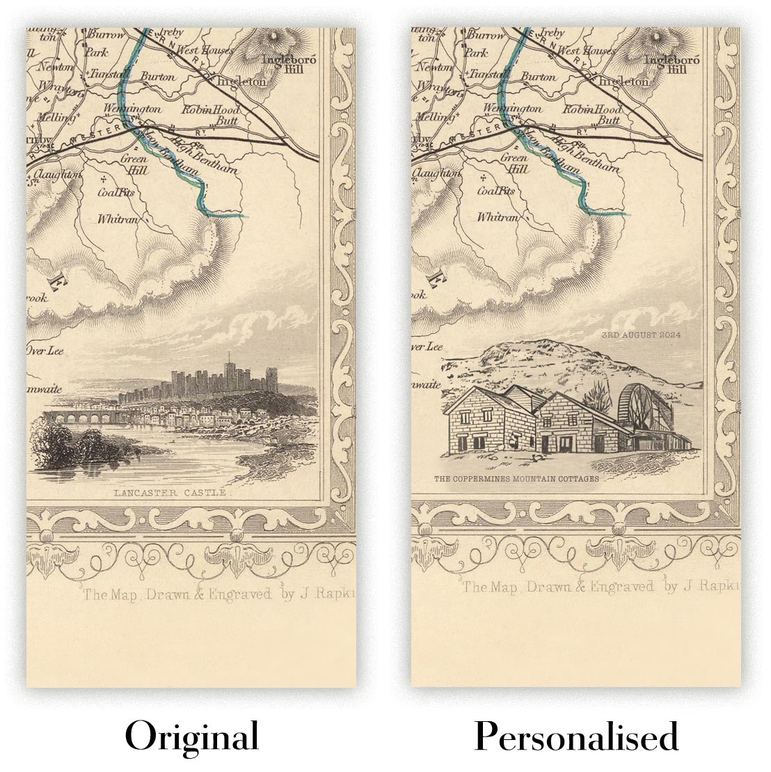
Personnalisation de la carte
Si vous recherchez le cadeau parfait pour un anniversaire ou une pendaison de crémaillère, je peux personnaliser votre carte pour la rendre vraiment unique. Par exemple, je peux ajouter un court message, mettre en évidence un lieu important ou ajouter les armoiries de votre famille.
Les options sont presque infinies. S'il vous plaît voir mon page de personnalisation de la carte pour quelques merveilleux exemples de ce qui est possible.
Pour commander une carte personnalisée, sélectionnez « personnaliser votre carte » avant de l'ajouter à votre panier.
Entrer en contact si vous recherchez des personnalisations et des personnalisations plus complexes.
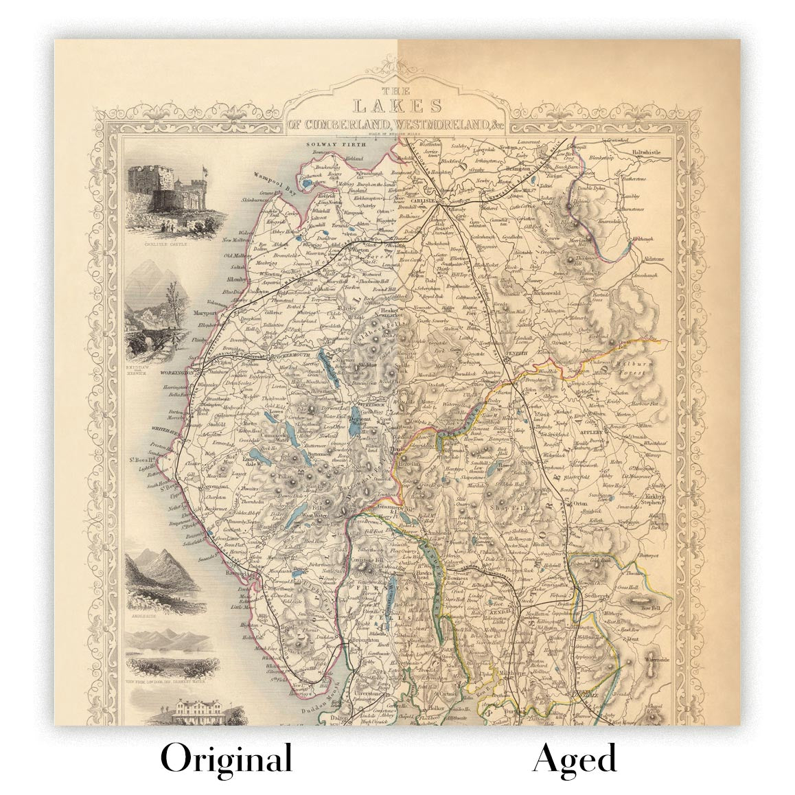
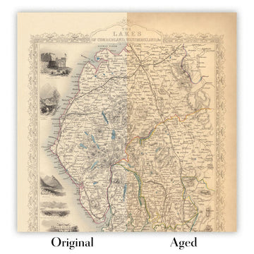
Vieillissement de la carte
Au fil des ans, des clients m'ont demandé des centaines de fois s'ils pouvaient acheter une carte qui semble uniforme. plus vieux.
Eh bien, vous pouvez désormais le faire en sélectionnant Aged avant d'ajouter une carte à votre panier.
Toutes les photos de produits que vous voyez sur cette page montrent la carte dans sa forme originale. Voilà à quoi ressemble la carte aujourd'hui.
Si vous sélectionnez Vieilli, je vieillirai votre carte à la main, en utilisant un processus spécial et unique développé au cours d'années d'étude de cartes anciennes, de discussions avec des chercheurs pour comprendre la chimie du vieillissement du papier, et bien sûr... beaucoup de pratique !
Si vous n'êtes pas sûr, respectez la couleur originale de la carte. Si vous voulez quelque chose d'un peu plus sombre et plus vieux à la recherche, optez pour Aged.
Si vous n'êtes pas satisfait de votre commande pour une raison quelconque, contactez-moi pour un remboursement sans conditions. Veuillez consulter notre politique de retours et de remboursements pour plus d'informations.
Je suis très confiant que vous aimerez votre carte restaurée ou votre impression artistique. Je fais cela depuis 1984. Je suis un vendeur Etsy 5 étoiles. J'ai vendu des dizaines de milliers de cartes et d'impressions artistiques et j'ai plus de 5 000 vrais avis 5 étoiles.
J'utilise un processus unique pour restaurer des cartes et des œuvres d'art qui est extrêmement chronophage et exigeant en main-d'œuvre. Trouver les cartes et illustrations originales peut prendre des mois. J'utilise une technologie de pointe et incroyablement coûteuse pour les numériser et les restaurer. En conséquence, je garantis que mes cartes et impressions artistiques sont d'une qualité supérieure - c'est pourquoi je peux offrir un remboursement sans conditions.
Presque toutes mes cartes et impressions artistiques ont l'air incroyables en grandes tailles (200 cm, 6,5 pieds+) et je peux également les encadrer et vous les livrer, via un transporteur spécial surdimensionné. Contactez-moi pour discuter de vos besoins spécifiques.
Or try searching for something!


