


Ancienne carte Bird's Eye d'Elbląg, Pologne, 1725: murs fortifiés, routes maritimes, églises, paysage rural
L’offre du collectionneur
Choisissez deux œuvres éligibles et bénéficiez de 20 % de réduction sur les deux. Choisissez-en trois et celle au prix le plus bas est offerte, pour une économie maximale de 33 %.
Associez librement des cartes standard éligibles et des tirages d’art. Aucun code n’est requis ; l’offre est appliquée automatiquement lors du paiement.
Les configurations standard réalisées sur commande sont incluses. Les formats sur mesure, les créations personnalisées et les œuvres commissionnées sont exclus.
Besoin d’une livraison à différentes adresses ? Contactez-nous avant de commander.L’offre du collectionneur
Choisissez deux œuvres éligibles et bénéficiez de 20 % de réduction sur les deux. Choisissez-en trois et celle au prix le plus bas est offerte, pour une économie maximale de 33 %.
Associez librement des cartes standard éligibles et des tirages d’art. Aucun code n’est requis ; l’offre est appliquée automatiquement lors du paiement.
Les configurations standard réalisées sur commande sont incluses. Les formats sur mesure, les créations personnalisées et les œuvres commissionnées sont exclus.
Besoin d’une livraison à différentes adresses ? Contactez-nous avant de commander. Conçu à Londres Fabriqué en the UK
Conçu à Londres • Fabriqué en the UK
Conçu à Londres Fabriqué en the UK
Conçu à Londres • Fabriqué en the UK

Restaurée à partir de la carte originale de 1725 et imprimée en qualité musée. Lire l’histoire de cette carte
Choose your size
Choose your finish


(Plus d’infos)
Message cadeau & finition personnalisée

Si vous souhaitez ajouter un message cadeau, ou une finition (puzzle, panneau en aluminium, etc.) qui n'est pas disponible ici, veuillez le demander dans la "note de commande" lors de votre passage à la caisse.
Chaque commande est fabriquée sur mesure, donc si vous avez besoin d'ajuster légèrement la taille, ou d'imprimer sur un matériau inhabituel, faites-le nous savoir. Nous avons réalisé des milliers de commandes personnalisées au fil des ans, donc il n'y a (presque) rien que nous ne puissions gérer.
Vous pouvez également nous contacter avant de passer votre commande, si vous le souhaitez !

- Fabriqué localement. Livraison sûre
- Sans droits ni frais cachés
- Besoin d’aide ? Appelez-nous ou message WhatsApp
Own a piece of history
8,000+ five-star reviews


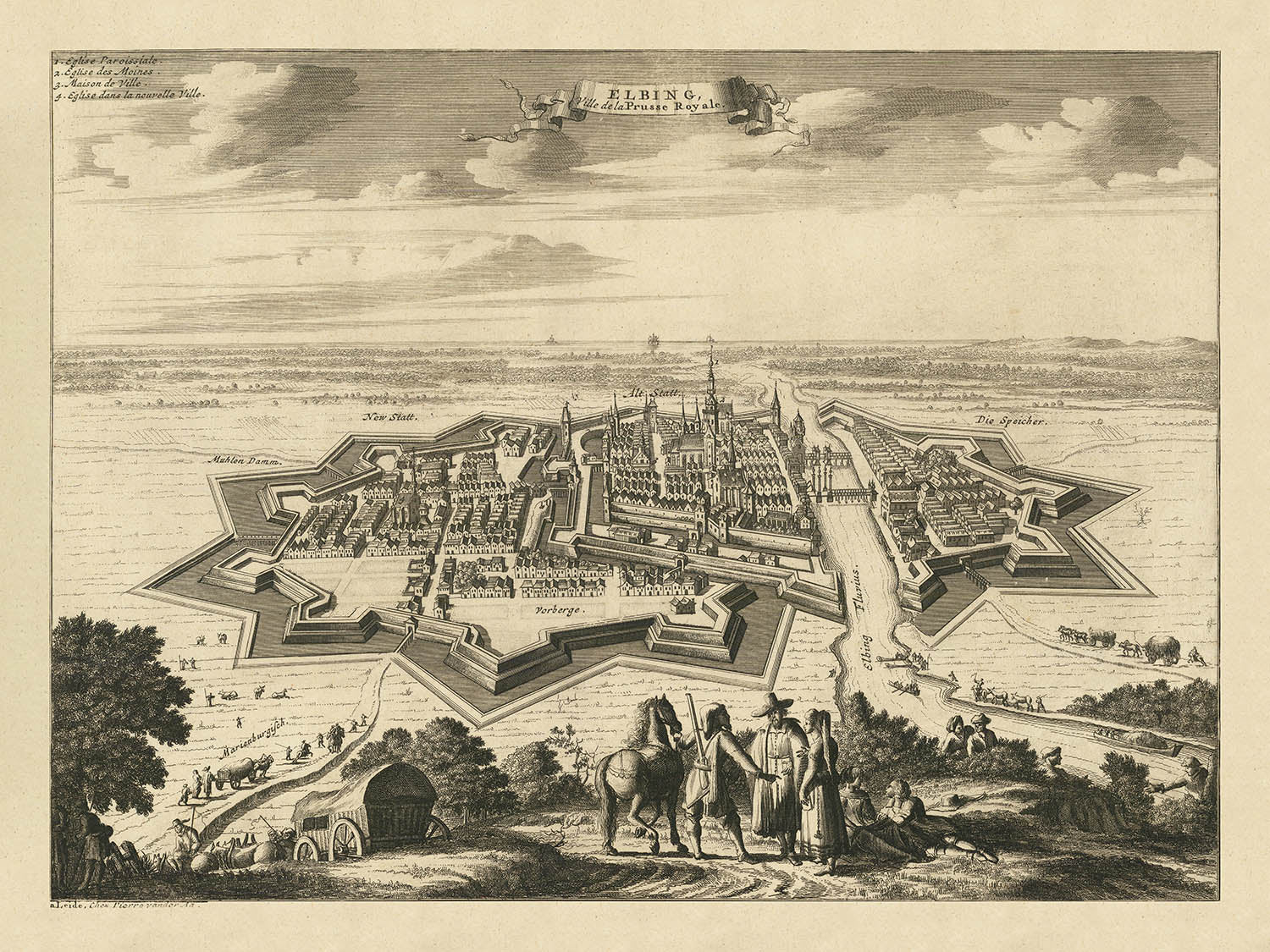
Entrez dans le passé légendaire de l'Europe du Nord avec "Elbing, Ville de la Prusse Royale," une magnifique vue aérienne d'Elbląg de...
Continuer la lectureEntrez dans le passé légendaire de l'Europe du Nord avec "Elbing, Ville de la Prusse Royale," une magnifique vue aérienne d'Elbląg de 1725—historiquement connu sous le nom d'Elbing—réalisée par le célèbre cartographe néerlandais Pieter van der Aa. Cette carte remarquable capture la ville fortifiée dans des détails époustouflants, offrant un rare aperçu du paysage urbain et architectural de la Prusse Royale au début du XVIIIe siècle. Le titre français original, élégamment affiché dans un cartouche décoratif, établit immédiatement le ton pour une pièce qui est autant une œuvre d'art qu'un document historique.
L'importance stratégique d'Elbląg en tant que centre commercial et bastion fortifié est illustrée de manière vivante dans cette carte. Les murs de la ville et les bastions méticuleusement rendus témoignent de son rôle en tant que rempart défensif, tandis que les voies navigables animées et les navires représentés sur la rivière soulignent ses connexions maritimes. Le plan de la ville prend vie grâce à la représentation soignée des églises, des tours et des bâtiments densément regroupés, tous nichés dans l'étreinte de robustes fortifications. Le paysage rural environnant, agrémenté de champs et de végétation verdoyante, encadre la ville et laisse entrevoir la richesse agricole qui soutenait sa prospérité.
Un des aspects les plus captivants de cette carte est sa capacité à transporter le spectateur dans les rythmes quotidiens d'Elbląg au XVIIIe siècle. La présence de figures costumées au premier plan ajoute une dimension humaine vivante, offrant un aperçu des modes et de la vie sociale de l'époque. Les voies navigables—artères du commerce et de la communication—sont peuplées de bateaux et de navires, soulignant le commerce dynamique de la ville et son rôle central dans la région baltique. Le rendu détaillé des monuments architecturaux invite à une inspection plus attentive, récompensant le spectateur avec un sentiment de découverte et de connexion au tissu historique de la ville.
Pieter van der Aa, le maître derrière cette carte, était célébré pour sa précision, son art et sa capacité à capturer l'essence des villes européennes à l'apogée de leur importance historique. Ses œuvres sont prisées par les collectionneurs et les historiens pour leur mélange d'exactitude et de finesse décorative. Dans cette carte, l'habileté de van der Aa est évidente non seulement dans le rendu technique des fortifications et du cœur urbain d'Elbląg, mais aussi dans les embellissements imaginatifs qui font vivre la scène. Son point de vue unique offre à la fois un enregistrement pratique et une vision romancée d'une ville à la croisée du commerce, de la culture et du conflit.
Pour les amateurs d'histoire cartographique, "Elbing, Ville de la Prusse Royale" se dresse comme un témoignage de l'attrait durable des cartes de ville. Elle encapsule la grandeur et la complexité d'un grand centre urbain de la Prusse Royale, capturant à la fois sa forme physique et son esprit historique. Que ce soit admirée pour sa beauté artistique, sa valeur documentaire, ou son évocation d'une époque révolue, cette carte est une pièce maîtresse pour toute collection—une invitation à explorer l'interaction complexe de la géographie, de l'histoire et de l'effort humain qui a façonné les villes de l'Europe moderne précoce.
Rues et routes sur cette carte
- Aucune rue ou route n'est clairement étiquetée ou lisible sur cette image de carte. Par conséquent, cette section ne peut pas être complétée.
Caractéristiques et monuments notables
- Murs de ville fortifiés et bastions clairement représentés
- Représentation détaillée des bâtiments de la ville, des églises et des tours
- Voies navigables et canaux proéminents traversant et entourant la ville
- Cartouche décorative en ruban avec le titre "Elbing, Ville de la Prusse Royale"
- Figures costumées représentées au premier plan, ajoutant un contexte décoratif et culturel
- Paysage rural environnant, champs et végétation clairement illustrés
- Bateaux et navires représentés sur les voies navigables, indiquant l'importance maritime et commerciale de la ville
Contexte historique et de design
- Créé en 1725 par Pieter van der Aa, un éditeur et cartographe néerlandais notable connu pour ses vues de villes détaillées et ses cartes au début du XVIIIe siècle
- Représente la ville d'Elbląg (Elbing), située dans le nord de la Pologne, dans la région historique de la Prusse Royale
- La carte est une vue d'oiseau picturale, offrant une représentation détaillée et artistique de l'agencement de la ville, des fortifications et du paysage environnant
- Met en avant la nature fortifiée de la ville, soulignant son importance stratégique et défensive
- Elbląg était historiquement important en tant que ville commerçante au sein de la Prusse Royale, faisant partie de la République des Deux Nations à l'époque
- Inclut des éléments décoratifs tels qu'une cartouche en ruban et des figures costumées au premier plan, typiques du style détaillé et ornemental de Pieter van der Aa
Veuillez vérifier les images pour vous assurer qu'une ville ou un lieu spécifique est montré sur cette carte. Vous pouvez également nous contacter et nous demander de vérifier la carte pour vous.
Cette carte a l'air superbe à toutes les tailles, mais je recommande toujours d'opter pour une taille plus grande si vous avez de l'espace. De cette façon, vous pouvez facilement distinguer tous les détails.
Cette carte a l'air incroyable à des tailles allant jusqu'à 50in (125cm). Si vous recherchez une carte plus grande, veuillez nous contacter.
Le modèle sur les images de la liste tient la version de cette carte en 18x24in (45x60cm).
La cinquième image de la liste montre un exemple de mon service de personnalisation de carte.
Si vous recherchez quelque chose de légèrement différent, consultez ma collection des meilleures anciennes cartes pour voir si quelque chose d'autre attire votre attention.
Veuillez me contacter pour vérifier si un certain emplacement, monument ou caractéristique est montré sur cette carte.
Cela ferait un merveilleux cadeau d'anniversaire, de Noël, pour la fête des pères, pour un départ au travail, un anniversaire de mariage ou une pendaison de crémaillère pour quelqu'un des régions couvertes par cette carte.
Cette carte est disponible en tant qu'impression giclée sur papier mat d'archivage sans acide, ou vous pouvez l'acheter encadrée. Le cadre est un joli cadre noir simple qui convient à la plupart des esthétiques. Veuillez nous contacter si vous souhaitez une couleur ou un matériau de cadre différent. Mes cadres sont en verre acrylique super clair de qualité musée (perspex/acrylite), qui est significativement moins réfléchissant que le verre, plus sûr, et arrivera toujours en parfait état.
This map is also available as a float framed canvas, sometimes known as a shadow gap framed canvas or canvas floater. The map is printed on artist's cotton canvas and then stretched over a handmade box frame. We then "float" the canvas inside a wooden frame, which is available in a range of colours (black, dark brown, oak, antique gold and white). This is a wonderful way to present a map without glazing in front. See some examples of float framed canvas maps and explore the differences between my different finishes.
For something truly unique, this map is also available in "Unique 3D", our trademarked process that dramatically transforms the map so that it has a wonderful sense of depth. We combine the original map with detailed topography and elevation data, so that mountains and the terrain really "pop". For more info and examples of 3D maps, check my Unique 3D page.
Entrez dans le passé légendaire de l'Europe du Nord avec "Elbing, Ville de la Prusse Royale," une magnifique vue aérienne d'Elbląg de 1725—historiquement connu sous le nom d'Elbing—réalisée par le célèbre cartographe néerlandais Pieter van der Aa. Cette carte remarquable capture la ville fortifiée dans des détails époustouflants, offrant un rare aperçu du paysage urbain et architectural de la Prusse Royale au début du XVIIIe siècle. Le titre français original, élégamment affiché dans un cartouche décoratif, établit immédiatement le ton pour une pièce qui est autant une œuvre d'art qu'un document historique.
L'importance stratégique d'Elbląg en tant que centre commercial et bastion fortifié est illustrée de manière vivante dans cette carte. Les murs de la ville et les bastions méticuleusement rendus témoignent de son rôle en tant que rempart défensif, tandis que les voies navigables animées et les navires représentés sur la rivière soulignent ses connexions maritimes. Le plan de la ville prend vie grâce à la représentation soignée des églises, des tours et des bâtiments densément regroupés, tous nichés dans l'étreinte de robustes fortifications. Le paysage rural environnant, agrémenté de champs et de végétation verdoyante, encadre la ville et laisse entrevoir la richesse agricole qui soutenait sa prospérité.
Un des aspects les plus captivants de cette carte est sa capacité à transporter le spectateur dans les rythmes quotidiens d'Elbląg au XVIIIe siècle. La présence de figures costumées au premier plan ajoute une dimension humaine vivante, offrant un aperçu des modes et de la vie sociale de l'époque. Les voies navigables—artères du commerce et de la communication—sont peuplées de bateaux et de navires, soulignant le commerce dynamique de la ville et son rôle central dans la région baltique. Le rendu détaillé des monuments architecturaux invite à une inspection plus attentive, récompensant le spectateur avec un sentiment de découverte et de connexion au tissu historique de la ville.
Pieter van der Aa, le maître derrière cette carte, était célébré pour sa précision, son art et sa capacité à capturer l'essence des villes européennes à l'apogée de leur importance historique. Ses œuvres sont prisées par les collectionneurs et les historiens pour leur mélange d'exactitude et de finesse décorative. Dans cette carte, l'habileté de van der Aa est évidente non seulement dans le rendu technique des fortifications et du cœur urbain d'Elbląg, mais aussi dans les embellissements imaginatifs qui font vivre la scène. Son point de vue unique offre à la fois un enregistrement pratique et une vision romancée d'une ville à la croisée du commerce, de la culture et du conflit.
Pour les amateurs d'histoire cartographique, "Elbing, Ville de la Prusse Royale" se dresse comme un témoignage de l'attrait durable des cartes de ville. Elle encapsule la grandeur et la complexité d'un grand centre urbain de la Prusse Royale, capturant à la fois sa forme physique et son esprit historique. Que ce soit admirée pour sa beauté artistique, sa valeur documentaire, ou son évocation d'une époque révolue, cette carte est une pièce maîtresse pour toute collection—une invitation à explorer l'interaction complexe de la géographie, de l'histoire et de l'effort humain qui a façonné les villes de l'Europe moderne précoce.
Rues et routes sur cette carte
- Aucune rue ou route n'est clairement étiquetée ou lisible sur cette image de carte. Par conséquent, cette section ne peut pas être complétée.
Caractéristiques et monuments notables
- Murs de ville fortifiés et bastions clairement représentés
- Représentation détaillée des bâtiments de la ville, des églises et des tours
- Voies navigables et canaux proéminents traversant et entourant la ville
- Cartouche décorative en ruban avec le titre "Elbing, Ville de la Prusse Royale"
- Figures costumées représentées au premier plan, ajoutant un contexte décoratif et culturel
- Paysage rural environnant, champs et végétation clairement illustrés
- Bateaux et navires représentés sur les voies navigables, indiquant l'importance maritime et commerciale de la ville
Contexte historique et de design
- Créé en 1725 par Pieter van der Aa, un éditeur et cartographe néerlandais notable connu pour ses vues de villes détaillées et ses cartes au début du XVIIIe siècle
- Représente la ville d'Elbląg (Elbing), située dans le nord de la Pologne, dans la région historique de la Prusse Royale
- La carte est une vue d'oiseau picturale, offrant une représentation détaillée et artistique de l'agencement de la ville, des fortifications et du paysage environnant
- Met en avant la nature fortifiée de la ville, soulignant son importance stratégique et défensive
- Elbląg était historiquement important en tant que ville commerçante au sein de la Prusse Royale, faisant partie de la République des Deux Nations à l'époque
- Inclut des éléments décoratifs tels qu'une cartouche en ruban et des figures costumées au premier plan, typiques du style détaillé et ornemental de Pieter van der Aa
Veuillez vérifier les images pour vous assurer qu'une ville ou un lieu spécifique est montré sur cette carte. Vous pouvez également nous contacter et nous demander de vérifier la carte pour vous.
Cette carte a l'air superbe à toutes les tailles, mais je recommande toujours d'opter pour une taille plus grande si vous avez de l'espace. De cette façon, vous pouvez facilement distinguer tous les détails.
Cette carte a l'air incroyable à des tailles allant jusqu'à 50in (125cm). Si vous recherchez une carte plus grande, veuillez nous contacter.
Le modèle sur les images de la liste tient la version de cette carte en 18x24in (45x60cm).
La cinquième image de la liste montre un exemple de mon service de personnalisation de carte.
Si vous recherchez quelque chose de légèrement différent, consultez ma collection des meilleures anciennes cartes pour voir si quelque chose d'autre attire votre attention.
Veuillez me contacter pour vérifier si un certain emplacement, monument ou caractéristique est montré sur cette carte.
Cela ferait un merveilleux cadeau d'anniversaire, de Noël, pour la fête des pères, pour un départ au travail, un anniversaire de mariage ou une pendaison de crémaillère pour quelqu'un des régions couvertes par cette carte.
Cette carte est disponible en tant qu'impression giclée sur papier mat d'archivage sans acide, ou vous pouvez l'acheter encadrée. Le cadre est un joli cadre noir simple qui convient à la plupart des esthétiques. Veuillez nous contacter si vous souhaitez une couleur ou un matériau de cadre différent. Mes cadres sont en verre acrylique super clair de qualité musée (perspex/acrylite), qui est significativement moins réfléchissant que le verre, plus sûr, et arrivera toujours en parfait état.
This map is also available as a float framed canvas, sometimes known as a shadow gap framed canvas or canvas floater. The map is printed on artist's cotton canvas and then stretched over a handmade box frame. We then "float" the canvas inside a wooden frame, which is available in a range of colours (black, dark brown, oak, antique gold and white). This is a wonderful way to present a map without glazing in front. See some examples of float framed canvas maps and explore the differences between my different finishes.
For something truly unique, this map is also available in "Unique 3D", our trademarked process that dramatically transforms the map so that it has a wonderful sense of depth. We combine the original map with detailed topography and elevation data, so that mountains and the terrain really "pop". For more info and examples of 3D maps, check my Unique 3D page.
Many of our maps and art prints are chosen as thoughtful gifts for homes, offices, studies and meaningful places.
Choose a framed option for the easiest ready-to-hang gift, or choose an unframed print if the recipient may prefer to select their own frame.
We make orders locally in 23 countries around the world, so gifts can often be produced close to the recipient. This helps them arrive faster, travel more safely, and avoid customs or import duty surprises.
- We can deliver directly to the recipient
- Framed pieces arrive ready to hang
- Unframed prints are carefully packed in a strong protective tube
- Almost every order is made locally, for faster, safer gifting
- 90-day returns give the recipient time to decide
If you are not sure what to choose, please contact us. We can help you pick the right map, size, finish or delivery option.
Pour la plupart des commandes, le délai de livraison est d'environ 3 jours ouvrables. Les produits personnalisés et sur mesure prennent plus de temps, car je dois faire la personnalisation et vous l'envoyer pour approbation, ce qui prend généralement 1 ou 2 jours.
Veuillez noter que les grandes commandes encadrées prennent généralement plus de temps à réaliser et à livrer.
Si vous avez besoin que votre commande arrive à une date précise, veuillez me contacter avant de passer votre commande afin que nous puissions trouver le meilleur moyen de nous assurer que vous receviez votre commande à temps.
J'imprime et encadre des cartes et des œuvres d'art dans 23 pays à travers le monde. Cela signifie que votre commande sera réalisée localement, ce qui réduit le temps de livraison et garantit qu'elle ne sera pas endommagée pendant le transport. Vous ne paierez jamais de droits de douane ou d'importation, et nous mettrons moins de CO2 dans l'air.
Toutes mes cartes et impressions artistiques sont bien emballées et envoyées dans un tube robuste si non encadrées, ou entourées de mousse si encadrées.
J'essaie d'envoyer toutes les commandes dans les 1 ou 2 jours suivant la réception de votre commande, bien que certains produits (comme les masques, les mugs et les sacs fourre-tout) puissent prendre plus de temps à réaliser.
Si vous choisissez Livraison Express lors du paiement, nous donnerons la priorité à votre commande et l'enverrons par un service de messagerie de 1 jour (Fedex, DHL, UPS, Parcelforce).
La livraison le lendemain est également disponible dans certains pays (États-Unis, Royaume-Uni, Singapour, Émirats Arabes Unis), mais veuillez essayer de commander tôt dans la journée afin que nous puissions l'envoyer à temps.
Lisez mon guide complet sur la livraison et la production locale
Mon cadre standard est un cadre en bois dur noir de style galerie. Il est simple et a un aspect assez moderne. Mon cadre standard mesure environ 20 mm (0,8 po) de large.
J'utilise de l'acrylique super clair (perspex/acrylite) pour le verre du cadre. C'est plus léger et plus sûr que le verre - et cela a meilleur aspect, car la réflexivité est plus faible.
Six couleurs de cadre standard sont disponibles gratuitement (noir, marron foncé, gris foncé, chêne, blanc et or antique). Des encadrements et montages/matelassages personnalisés sont disponibles si vous recherchez autre chose.
La plupart des cartes, œuvres d'art et illustrations sont également disponibles sous forme de toile encadrée. Nous utilisons une toile en coton mate (non brillante), que nous tendons sur un cadre en bois de boîte provenant de sources durables, puis nous 'flottions' la pièce à l'intérieur d'un cadre en bois. Le résultat final est assez beau, et il n'y a pas de vitrage qui gêne.
Tous les cadres sont fournis "prêts à accrocher", avec soit une corde, soit des supports à l'arrière. Les très grands cadres auront des plaques de suspension lourdes et/ou une latte de montage. Si vous avez des questions, veuillez nous contacter.
Voir quelques exemples de mes cartes encadrées et de cartes en toile encadrées.
Alternativement, je peux également fournir de vieilles cartes et œuvres d'art sur toile, sur panneau en mousse, en coton et d'autres matériaux.
Si vous souhaitez encadrer votre carte ou œuvre d'art vous-même, veuillez lire d'abord mon guide des tailles.
Mes cartes sont des reproductions de cartes originales de très haute qualité.
Je recherche des cartes originales et rares auprès de bibliothèques, de maisons de ventes aux enchères et de collections privées du monde entier, je les restaure dans mon atelier de Londres, puis j'utilise des encres et des imprimantes giclées spécialisées pour créer de magnifiques cartes encore plus belles que l'originale.
Mes cartes sont imprimées sur du papier d’archives mat (non brillant) sans acide qui semble de très haute qualité et ressemble presque à une carte. En termes techniques, le grammage/épaisseur du papier est de 10 mil/200 g/m². C'est parfait pour l'encadrement.
J’imprime avec des encres pigmentaires Epson ultrachrome giclée UV résistantes à la décoloration – certaines des meilleures encres que vous puissiez trouver.
je peux aussi faire cartes sur toile, chiffon en coton et autres matériaux exotiques.
En savoir plus sur Unique Maps Co..
Personnalisation de la carte
Si vous recherchez le cadeau parfait pour un anniversaire ou une pendaison de crémaillère, je peux personnaliser votre carte pour la rendre vraiment unique. Par exemple, je peux ajouter un court message, mettre en évidence un lieu important ou ajouter les armoiries de votre famille.
Les options sont presque infinies. S'il vous plaît voir mon page de personnalisation de la carte pour quelques merveilleux exemples de ce qui est possible.
Pour commander une carte personnalisée, sélectionnez « personnaliser votre carte » avant de l'ajouter à votre panier.
Entrer en contact si vous recherchez des personnalisations et des personnalisations plus complexes.
Vieillissement de la carte
Au fil des ans, des clients m'ont demandé des centaines de fois s'ils pouvaient acheter une carte qui semble uniforme. plus vieux.
Eh bien, vous pouvez désormais le faire en sélectionnant Aged avant d'ajouter une carte à votre panier.
Toutes les photos de produits que vous voyez sur cette page montrent la carte dans sa forme originale. Voilà à quoi ressemble la carte aujourd'hui.
Si vous sélectionnez Vieilli, je vieillirai votre carte à la main, en utilisant un processus spécial et unique développé au cours d'années d'étude de cartes anciennes, de discussions avec des chercheurs pour comprendre la chimie du vieillissement du papier, et bien sûr... beaucoup de pratique !
Si vous n'êtes pas sûr, respectez la couleur originale de la carte. Si vous voulez quelque chose d'un peu plus sombre et plus vieux à la recherche, optez pour Aged.
Si vous n'êtes pas satisfait de votre commande pour une raison quelconque, contactez-moi pour un remboursement sans conditions. Veuillez consulter notre politique de retours et de remboursements pour plus d'informations.
Je suis très confiant que vous aimerez votre carte restaurée ou votre impression artistique. Je fais cela depuis 1984. Je suis un vendeur Etsy 5 étoiles. J'ai vendu des dizaines de milliers de cartes et d'impressions artistiques et j'ai plus de 5 000 vrais avis 5 étoiles.
J'utilise un processus unique pour restaurer des cartes et des œuvres d'art qui est extrêmement chronophage et exigeant en main-d'œuvre. Trouver les cartes et illustrations originales peut prendre des mois. J'utilise une technologie de pointe et incroyablement coûteuse pour les numériser et les restaurer. En conséquence, je garantis que mes cartes et impressions artistiques sont d'une qualité supérieure - c'est pourquoi je peux offrir un remboursement sans conditions.
Presque toutes mes cartes et impressions artistiques ont l'air incroyables en grandes tailles (200 cm, 6,5 pieds+) et je peux également les encadrer et vous les livrer, via un transporteur spécial surdimensionné. Contactez-moi pour discuter de vos besoins spécifiques.
Or try searching for something!


